LOGS FOR JANUARY 1948
https://s3.amazonaws.com/NARAprodstorage/opastorage/live/50/5479/38547950/content/dc-metro/rg-026/559642/2017-01/storis-wmec-38-1948/storis-wmec-38-1948_0001.JPG
https://s3.amazonaws.com/NARAprodstorage/opastorage/live/50/5479/38547950/content/dc-metro/rg-026/559642/2017-01/storis-wmec-38-1948/storis-wmec-38-1948_0002.JPG
https://s3.amazonaws.com/NARAprodstorage/opastorage/live/50/5479/38547950/content/dc-metro/rg-026/559642/2017-01/storis-wmec-38-1948/storis-wmec-38-1948_0003.JPG
https://s3.amazonaws.com/NARAprodstorage/opastorage/live/50/5479/38547950/content/dc-metro/rg-026/559642/2017-01/storis-wmec-38-1948/storis-wmec-38-1948_0004.JPG
https://s3.amazonaws.com/NARAprodstorage/opastorage/live/50/5479/38547950/content/dc-metro/rg-026/559642/2017-01/storis-wmec-38-1948/storis-wmec-38-1948_0005.JPG
1 January 1948
At/From ???
Lat 39.2, Long -76.57
Noon: CG Yard, Curtis Bay MD
https://s3.amazonaws.com/NARAprodstorage/opastorage/live/50/5479/38547950/content/dc-metro/rg-026/559642/2017-01/storis-wmec-38-1948/storis-wmec-38-1948_0006.JPG
2 January 1948
At/From ???
Lat 39.2, Long -76.57
Noon: CG Yard, Curtis Bay MD
https://s3.amazonaws.com/NARAprodstorage/opastorage/live/50/5479/38547950/content/dc-metro/rg-026/559642/2017-01/storis-wmec-38-1948/storis-wmec-38-1948_0007.JPG
3 January 1948
At/From ???
Lat 39.2, Long -76.57
Noon: CG Yard, Curtis Bay MD
https://s3.amazonaws.com/NARAprodstorage/opastorage/live/50/5479/38547950/content/dc-metro/rg-026/559642/2017-01/storis-wmec-38-1948/storis-wmec-38-1948_0008.JPG
4 January 1948
At/From ???
Lat 39.2, Long -76.57
Noon: CG Yard, Curtis Bay MD
https://s3.amazonaws.com/NARAprodstorage/opastorage/live/50/5479/38547950/content/dc-metro/rg-026/559642/2017-01/storis-wmec-38-1948/storis-wmec-38-1948_0009.JPG
5 January 1948
At/From ???
Lat 39.2, Long -76.57
Noon: CG Yard, Curtis Bay MD
https://s3.amazonaws.com/NARAprodstorage/opastorage/live/50/5479/38547950/content/dc-metro/rg-026/559642/2017-01/storis-wmec-38-1948/storis-wmec-38-1948_0010.JPG
6 January 1948
At/From ???
Lat 39.2, Long -76.57
Noon: CG Yard, Curtis Bay MD
https://s3.amazonaws.com/NARAprodstorage/opastorage/live/50/5479/38547950/content/dc-metro/rg-026/559642/2017-01/storis-wmec-38-1948/storis-wmec-38-1948_0011.JPG
7 January 1948
At/From ???
Lat 39.2, Long -76.57
Noon: CG Yard, Curtis Bay MD
https://s3.amazonaws.com/NARAprodstorage/opastorage/live/50/5479/38547950/content/dc-metro/rg-026/559642/2017-01/storis-wmec-38-1948/storis-wmec-38-1948_0012.JPG
8 January 1948
At/From ???
Lat 39.2, Long -76.57
Noon: CG Yard, Curtis Bay MD
https://s3.amazonaws.com/NARAprodstorage/opastorage/live/50/5479/38547950/content/dc-metro/rg-026/559642/2017-01/storis-wmec-38-1948/storis-wmec-38-1948_0013.JPG
9 January 1948
At/From ???
Lat 39.2, Long -76.57
Noon: CG Yard, Curtis Bay MD
https://s3.amazonaws.com/NARAprodstorage/opastorage/live/50/5479/38547950/content/dc-metro/rg-026/559642/2017-01/storis-wmec-38-1948/storis-wmec-38-1948_0014.JPG
10 January 1948
At/From ???
Lat 39.2, Long -76.57
Noon: CG Yard, Curtis Bay MD
https://s3.amazonaws.com/NARAprodstorage/opastorage/live/50/5479/38547950/content/dc-metro/rg-026/559642/2017-01/storis-wmec-38-1948/storis-wmec-38-1948_0015.JPG
11 January 1948
At/From ???
Lat 39.2, Long -76.57
Noon: CG Yard, Curtis Bay MD
https://s3.amazonaws.com/NARAprodstorage/opastorage/live/50/5479/38547950/content/dc-metro/rg-026/559642/2017-01/storis-wmec-38-1948/storis-wmec-38-1948_0016.JPG
12 January 1948
At/From ???
Lat 39.2, Long -76.57
Noon: CG Yard, Curtis Bay MD
https://s3.amazonaws.com/NARAprodstorage/opastorage/live/50/5479/38547950/content/dc-metro/rg-026/559642/2017-01/storis-wmec-38-1948/storis-wmec-38-1948_0017.JPG
13 January 1948
At/From ???
Lat 39.2, Long -76.57
Noon: CG Yard, Curtis Bay MD
https://s3.amazonaws.com/NARAprodstorage/opastorage/live/50/5479/38547950/content/dc-metro/rg-026/559642/2017-01/storis-wmec-38-1948/storis-wmec-38-1948_0018.JPG
14 January 1948
At/From ???
Lat 39.2, Long -76.57
Noon: CG Yard, Curtis Bay MD
https://s3.amazonaws.com/NARAprodstorage/opastorage/live/50/5479/38547950/content/dc-metro/rg-026/559642/2017-01/storis-wmec-38-1948/storis-wmec-38-1948_0019.JPG
15 January 1948
At/From ???
Lat 39.2, Long -76.57
Noon: CG Yard, Curtis Bay MD
https://s3.amazonaws.com/NARAprodstorage/opastorage/live/50/5479/38547950/content/dc-metro/rg-026/559642/2017-01/storis-wmec-38-1948/storis-wmec-38-1948_0020.JPG
16 January 1948
At/From ???
Lat 39.2, Long -76.57
Noon: CG Yard, Curtis Bay MD
https://s3.amazonaws.com/NARAprodstorage/opastorage/live/50/5479/38547950/content/dc-metro/rg-026/559642/2017-01/storis-wmec-38-1948/storis-wmec-38-1948_0021.JPG
17 January 1948
At/From ???
Lat 39.2, Long -76.57
Noon: CG Yard, Curtis Bay MD
https://s3.amazonaws.com/NARAprodstorage/opastorage/live/50/5479/38547950/content/dc-metro/rg-026/559642/2017-01/storis-wmec-38-1948/storis-wmec-38-1948_0022.JPG
18 January 1948
At/From ???
Lat 39.2, Long -76.57
Noon: CG Yard, Curtis Bay MD
https://s3.amazonaws.com/NARAprodstorage/opastorage/live/50/5479/38547950/content/dc-metro/rg-026/559642/2017-01/storis-wmec-38-1948/storis-wmec-38-1948_0023.JPG
19 January 1948
At/From ???
Lat 39.2, Long -76.57
Noon: CG Yard, Curtis Bay MD
https://s3.amazonaws.com/NARAprodstorage/opastorage/live/50/5479/38547950/content/dc-metro/rg-026/559642/2017-01/storis-wmec-38-1948/storis-wmec-38-1948_0024.JPG
20 January 1948
At/From ???
Lat 39.2, Long -76.57
Noon: CG Yard, Curtis Bay MD
https://s3.amazonaws.com/NARAprodstorage/opastorage/live/50/5479/38547950/content/dc-metro/rg-026/559642/2017-01/storis-wmec-38-1948/storis-wmec-38-1948_0025.JPG
21 January 1948
At/From ???
Lat 39.2, Long -76.57
Noon: CG Yard, Curtis Bay MD
https://s3.amazonaws.com/NARAprodstorage/opastorage/live/50/5479/38547950/content/dc-metro/rg-026/559642/2017-01/storis-wmec-38-1948/storis-wmec-38-1948_0026.JPG
22 January 1948
At/From ???
Lat 39.2, Long -76.57
Noon: CG Yard, Curtis Bay MD
https://s3.amazonaws.com/NARAprodstorage/opastorage/live/50/5479/38547950/content/dc-metro/rg-026/559642/2017-01/storis-wmec-38-1948/storis-wmec-38-1948_0027.JPG
23 January 1948
At/From ???
Lat 39.2, Long -76.57
Noon: CG Yard, Curtis Bay MD
https://s3.amazonaws.com/NARAprodstorage/opastorage/live/50/5479/38547950/content/dc-metro/rg-026/559642/2017-01/storis-wmec-38-1948/storis-wmec-38-1948_0028.JPG
24 January 1948
At/From ???
Lat 39.2, Long -76.57
Noon: CG Yard, Curtis Bay MD
https://s3.amazonaws.com/NARAprodstorage/opastorage/live/50/5479/38547950/content/dc-metro/rg-026/559642/2017-01/storis-wmec-38-1948/storis-wmec-38-1948_0029.JPG
25 January 1948
At/From ???
Lat 39.2, Long -76.57
Noon: CG Yard, Curtis Bay MD
https://s3.amazonaws.com/NARAprodstorage/opastorage/live/50/5479/38547950/content/dc-metro/rg-026/559642/2017-01/storis-wmec-38-1948/storis-wmec-38-1948_0030.JPG
26 January 1948
At/From ???
Lat 39.2, Long -76.57
Noon: CG Yard, Curtis Bay MD
https://s3.amazonaws.com/NARAprodstorage/opastorage/live/50/5479/38547950/content/dc-metro/rg-026/559642/2017-01/storis-wmec-38-1948/storis-wmec-38-1948_0031.JPG
27 January 1948
At/From ???
Lat 39.2, Long -76.57
Noon: CG Yard, Curtis Bay MD
https://s3.amazonaws.com/NARAprodstorage/opastorage/live/50/5479/38547950/content/dc-metro/rg-026/559642/2017-01/storis-wmec-38-1948/storis-wmec-38-1948_0032.JPG
28 January 1948
At/From ???
Lat 39.2, Long -76.57
Noon: CG Yard, Curtis Bay MD
https://s3.amazonaws.com/NARAprodstorage/opastorage/live/50/5479/38547950/content/dc-metro/rg-026/559642/2017-01/storis-wmec-38-1948/storis-wmec-38-1948_0033.JPG
29 January 1948
At/From ???
Lat 39.2, Long -76.57
Noon: CG Yard, Curtis Bay MD
https://s3.amazonaws.com/NARAprodstorage/opastorage/live/50/5479/38547950/content/dc-metro/rg-026/559642/2017-01/storis-wmec-38-1948/storis-wmec-38-1948_0034.JPG
30 January 1948
At/From ???
Lat 39.2, Long -76.57
Noon: CG Yard, Curtis Bay MD
https://s3.amazonaws.com/NARAprodstorage/opastorage/live/50/5479/38547950/content/dc-metro/rg-026/559642/2017-01/storis-wmec-38-1948/storis-wmec-38-1948_0035.JPG
https://s3.amazonaws.com/NARAprodstorage/opastorage/live/50/5479/38547950/content/dc-metro/rg-026/559642/2017-01/storis-wmec-38-1948/storis-wmec-38-1948_0036.JPG
31 January 1948
At/From ???
Lat 39.2, Long -76.57
Noon: CG Yard, Curtis Bay MD
LOGS FOR FEBRUARY 1948
https://s3.amazonaws.com/NARAprodstorage/opastorage/live/50/5479/38547950/content/dc-metro/rg-026/559642/2017-01/storis-wmec-38-1948/storis-wmec-38-1948_0037.JPG
https://s3.amazonaws.com/NARAprodstorage/opastorage/live/50/5479/38547950/content/dc-metro/rg-026/559642/2017-01/storis-wmec-38-1948/storis-wmec-38-1948_0038.JPG
https://s3.amazonaws.com/NARAprodstorage/opastorage/live/50/5479/38547950/content/dc-metro/rg-026/559642/2017-01/storis-wmec-38-1948/storis-wmec-38-1948_0039.JPG
https://s3.amazonaws.com/NARAprodstorage/opastorage/live/50/5479/38547950/content/dc-metro/rg-026/559642/2017-01/storis-wmec-38-1948/storis-wmec-38-1948_0040.JPG
https://s3.amazonaws.com/NARAprodstorage/opastorage/live/50/5479/38547950/content/dc-metro/rg-026/559642/2017-01/storis-wmec-38-1948/storis-wmec-38-1948_0041.JPG
1 February 1948
At/From ???
Lat 39.2, Long -76.57
Noon: CG Yard, Curtis Bay MD
https://s3.amazonaws.com/NARAprodstorage/opastorage/live/50/5479/38547950/content/dc-metro/rg-026/559642/2017-01/storis-wmec-38-1948/storis-wmec-38-1948_0042.JPG
2 February 1948
At/From ???
Lat 39.27, Long -76.57
08.14:
10.43: Moored Std. Oil Dock
13.35:
15.20: cc 090. 1535 cc 012.
16.15: Bell Buoy 3 close aboard to port. cc 049.
17.14: Buoy 5 close aboard cc 049. 1733 Anchored. Brgs Pooles North
Range Front 315, Rocky Pt 106, Worton Pt 178
Noon: Standard Oil Dock, Baltimore
https://s3.amazonaws.com/NARAprodstorage/opastorage/live/50/5479/38547950/content/dc-metro/rg-026/559642/2017-01/storis-wmec-38-1948/storis-wmec-38-1948_0043.JPG
3 February 1948
At/From ???
Lat 39.39, Long -76.07
00.00: Anchored in Chesapeake Bay at the mouth of Bush river. Brgs
Lower Range Light 315T, Rocky Pt, 106, Worton Point 178.
07.06: Proceeding up channel enroute to Chesapeake and Delaware
Canal.
08.00: Underway in ice standing up Chesapeake Bay
10.05: Abeam Wroth Pt distant one mi to stbd. Standing by to assist
...
11.10: Underway cc 225 to assist convoy through ice. 1130 Took sttion
one mile forward of convoy, engaged in ice breaking.
12.30: 1230 cc 229.
13.05: cc 205. 1320 cc 195. 1326 cc 186.
15.08: cc 192. 1530 175.
17.30: Anchored in Area 4 Baltimore Harbor. Brgs Dundalk Acre Beacon
20.5T, Fort Carroll Light 142.5T, Sollers Pt Mooring 047T.
Noon: Off George Pt. C&D Canal Approaches
https://s3.amazonaws.com/NARAprodstorage/opastorage/live/50/5479/38547950/content/dc-metro/rg-026/559642/2017-01/storis-wmec-38-1948/storis-wmec-38-1948_0044.JPG
https://s3.amazonaws.com/NARAprodstorage/opastorage/live/50/5479/38547950/content/dc-metro/rg-026/559642/2017-01/storis-wmec-38-1948/storis-wmec-38-1948_0045.JPG
4 February 1948
At/From ???
Lat 39.2, Long -76.5
Noon: Anchored General Anchorage No 4 off Sparrows Point. Brgs
Dundalk Aero Beacon 020.5T, Fort Carrol Lt 142, Sollers Pt Mooring
047
06.55:
08.15: Craig Hill Channel Buoy 8C brg 000T dist 1000 yds.
10.07: Craighill Channel Buoy 6C close aboard to stbd, cc 000T. 1053
Close aboard Cutoff Channel buoy 5K, cc 025.
11.15: Engaged in rendering ice breaking assistance to Esso Delivery
#7 and F. M. Latrode enroute Baltimore Harbor in convoy.
11.44: Close aboard Brewetop Channel Buoy 3G cc var. 1158 Secured
assitance to Esso Delivery #7 and F. M Latrobe.
12.18: Proceeding to Vicinity Cove Point.
13.39: cc 164. 1355 cc 193
15.32: cc 177
16.52: Departed Sharps Is Lighted Buoy on course 356T
19.45: cc 013T
Noon: Bermerton Channel, Baltimore
20.20: Bloody Point Bar Lt abeam to stbd dist 11/2 mi.
22.52: Sandy Pt Lt abeam to port dist 1000 yds, cc 344T
23.40: Craighill Channel Lighted buoy 1C close aboard to port, cc v,
assisting tug and tow through ice.
20.00: Underway as before escorting tug and tow through ice.
https://s3.amazonaws.com/NARAprodstorage/opastorage/live/50/5479/38547950/content/dc-metro/rg-026/559642/2017-01/storis-wmec-38-1948/storis-wmec-38-1948_0046.JPG
https://s3.amazonaws.com/NARAprodstorage/opastorage/live/50/5479/38547950/content/dc-metro/rg-026/559642/2017-01/storis-wmec-38-1948/storis-wmec-38-1948_0047.JPG
5 February 1948
At/From ???
Lat 39.26, Long -76.55
00.00: Underway on course 344T escorting tug and brch through the
ice.
00.30: Craig Hill Channel Lt 1c close about cc var to break tug and
tow out of the ice.
04.40: Broke tug and tow out of ice. 0450 proceeding up channel
breaking ice for tug and tow.
08.00: Underway crse 292T escorting tug and tow through ice. 0829
Clear of ice field section. secured ice breaking assistance.
08.17: Channel buoy 4M close abord to stbd, cc 321T. 0834 abeam Fort
Carrol Lt dist 500 yds. 0845 Hove to in anchorage area 2.
11.15: Underway enroute anchorage 5. 1130 anchored. Brgs Quarantine
Station Tank, leading Point 184T, Church Spire, Brooklyn 281T,
Wagner's Pt Tank 307.5
12.58: Underway down Baltimore Harbor.
14.48: Sandy Point Lt abeam to stbd
17.05: Anchored in Naval Anchorage off Annapolis Harbor. Brgs
Southern Radio Town Greenbury Pt 305T Thomas Pt Shoal Lt 190T Sandy
Pt Lt 027T, Greenbury Pt Shoal Lt 291T.
Noon: Curtis Bay
0030 Crag Hill Channel LT 1c close aboard
https://s3.amazonaws.com/NARAprodstorage/opastorage/live/50/5479/38547950/content/dc-metro/rg-026/559642/2017-01/storis-wmec-38-1948/storis-wmec-38-1948_0048.JPG
https://s3.amazonaws.com/NARAprodstorage/opastorage/live/50/5479/38547950/content/dc-metro/rg-026/559642/2017-01/storis-wmec-38-1948/storis-wmec-38-1948_0049.JPG
6 February 1948
At/From ???
Lat 39.5, Long -75.93
06.55: Underway cc var
07.23: Sandy Pt Lt abeam to port dist 1/2 mi. cc 027T. 0755 cc 012T
08.05: Upper Chesapeake Bay light bell buoy #2 abeam to stbd dist 500
yds. 0818
08.18: Upper Swan Pt lighted bell buoy #4 close aboard to stbd, cc
44. 0828 Upper Swan Pt lighted bell buoy #6 close aboard to stbd cc
15.
09.17: Upper Chesapeake Channel lighted bell buoy #5 close aboard to
port cc 49. 0950 Shadd Battery Channel light buoy #1 close aboard to
port, cc 058.
10.41: Howell Pt Channel light buoy #3 close aboard to port cc 042T
11.43: Arnold Pt Lt brg 180T dist 800 yds cc 046. 1155 Maneuvering
off Hylands Pt to turn for swd heading.
12.35: Completed turn, headed out Elk River at Town's Pt Buoy #2,
laying to.
13.57: Underway cc 226 assisting CGC Chinook to break ice
14.27: Overtook barge ice bound in the channel off Turkey Pt.
15.00:
Noon: Off Hyland Point Elk River
15.00: Beaking ice
16.08: Grove Pt abeam to port 1,000 yds cc 246. 1640 Horwell Pt Lt
abeam to port one half mile, cc 238T.
17.30: Worton Pt abeam to port. 1745 Upper Chesapeake Buoy#5 abeam
close aboard to stbd cc 195.
19.00: Stopped by ice Tolchester Beach Lt brg 040T and Upper
Chesapeake Middle Ground Lighted bell buoy brg 196.
20.00: Hove to in heavy ice as before. 2002 Underway assisting M.L.
Sylvia through ice; steering various courses at various speeds to
clear ice field.
20.30: cc 224
21.02: Abeam B ermerton Channel Extension buoy #1, dist 1000 yds to
port. 2112 Buoy close aboard to port, cc 360T. 2120 Anchored off
Bermerton CHannel extension. Brgs Craighill Channel Range Lt 300,
Swan Pt Lt "M: 105T
09.17: Upper Chesapeake Channel lighted bell buoy #5 close aboard to
port cc 49. 0950 Shad Battery Channel light buoy #1 close aboard to
port, cc 058.
1143 : Arnold Pt Lt brg 180T dist 800 yds cc 046. 1155 Maneuvering
off Hylands Pt to turn for swd heading.
1427 Off Turkey Point
21.02: Abeam Brewerton Channel Extension buoy #1, dist 1000 yds to
port. 2112 Buoy close aboard to port, cc 360T. 2120 Anchored off
Brewerton Channel extension. Brgs Craighill Channel Range Lt 300,
Swan Pt Lt ""M"" 105T
Swan Point brg 105 degs. True 1 mile
https://s3.amazonaws.com/NARAprodstorage/opastorage/live/50/5479/38547950/content/dc-metro/rg-026/559642/2017-01/storis-wmec-38-1948/storis-wmec-38-1948_0050.JPG
7 February 1948
At/From ???
Lat 39.17, Long -76.31
06.57:
07.28: Tolchester Lt abeam one half mile to stbd. 0749 anchored. 1000
yds NNE of Upper Chesapeake Channel Lighted Bell Buoy #1
09.20: Anchor aweigh. 0925 Close aboard Upper Chesapeake Bay buoy #6
to stbd cc 049. 0928 came about, cc 229. 0932 Tolchester Beah Light
beacon brg 175 dist 1000 yds, cc 224. 1032 Anchored off Bremerton
Channel Extension brgs Swan Pt Tower A 124, Swan Pt Tower B 070,
Craig Hill Channel Front range 285T.
https://s3.amazonaws.com/NARAprodstorage/opastorage/live/50/5479/38547950/content/dc-metro/rg-026/559642/2017-01/storis-wmec-38-1948/storis-wmec-38-1948_0051.JPG
https://s3.amazonaws.com/NARAprodstorage/opastorage/live/50/5479/38547950/content/dc-metro/rg-026/559642/2017-01/storis-wmec-38-1948/storis-wmec-38-1948_0052.JPG
8 February 1948
At/From ???
Lat 39.45, Long -76
09.00: Underway in ice cc 044.
09.21: cc 015. 0926 Tolchester Beach lighted beacon abeam to stbd
dist 1500 yds.
10.18: Shad Battery Shoal Channel buoy #1 close aboard to port cc
058T. 1048 Howell Pt Channel buoy #1 close aboard to port cc 065.
11.06: Grove Neck Channel buo #1 close abard to stbd.
11.10: Drifting in ice. 1118 Underway maneuvering to assist tug and
tow in ice. 1156 Assisting M.L. Sylvia in ice
12.45: Passed cable to Sylvia who was stuck in the ice.
13.00: Proceeded leading all ships.
15.03: Entered Chesapeake and Delaware Canal.
18.37: Moored one half mi E or Reedy Point Bridge.
11.06: Grove Neck Channel buoy #1 close abard to stbd.
https://s3.amazonaws.com/NARAprodstorage/opastorage/live/50/5479/38547950/content/dc-metro/rg-026/559642/2017-01/storis-wmec-38-1948/storis-wmec-38-1948_0053.JPG
9 February 1948
At/From ???
Lat 39.54, Long -75.58
12.52: Underway to break ice for tugs and barge.
14.40: Proceeding west in the Chesapeake and Delaware Canal on
various courses and speeds
16.33: Left escorted ships off Courthouse Point. Proceeding west to
break ships out of ice off Grove Neck.
17.08: Passed stuck vessels and again at 1738.
17.48: Abeam Grove Neck, reversed course heading eastward.
18.30: cc 042
19.25: Abeam Arnold's Point. 1943 cc 046.
20.01: Steering various courses and speeds breaking the ice.
20.45: Dropped tow. Proceeded to mooring dolphin one mile west of
Chesapeake City.
https://s3.amazonaws.com/NARAprodstorage/opastorage/live/50/5479/38547950/content/dc-metro/rg-026/559642/2017-01/storis-wmec-38-1948/storis-wmec-38-1948_0054.JPG
10 February 1948
At/From ???
Lat 39.45, Long -76
08.52: Vessel enroute to the westerly end of C&D Canal
12.53: Dropped tow to break ice in channel
13.27: Abeam of Grove Pt Neck turned around and proceeded up the
channel.
13.37: Freed the W.A. Weber from the ice.
17.35: Moored to dolphin one mile west of Chesapeake City.
11.40: Turkey Pt abeam to stbd
https://s3.amazonaws.com/NARAprodstorage/opastorage/live/50/5479/38547950/content/dc-metro/rg-026/559642/2017-01/storis-wmec-38-1948/storis-wmec-38-1948_0055.JPG
11 February 1948
At/From ???
Lat 39.42, Long -76.03
08.00: Underway, proceeding eastward. 0815 Tug helps turn vessal at
ferry crossing Chesapeake City. 0837 Completed turn, proceeding
westward.
0900-1200: In ice standing westward in C&D Canal.
10.30: Turkey Pt abeam to stbd.
12.01: cc 246. 1250 cc 238.
13.07: cc 228. 1320 Stopped. 1329 cc 195
14.11: Tolchester Beach Lt abearm to port cc 224. 1429 cc 265
15.10: Craigheill Channel Buoy 6C abeam to port, entered channel of
Baltimore Harbor.
17.00: Maneuvering to turn in C.G. Yard Basin, Curtis Bay. 1725
Moored Berth 3C
20.00: Berth 3C Yard
14.11: Tolchester Beach Lt abeam to port cc 224. 1429 cc 265
https://s3.amazonaws.com/NARAprodstorage/opastorage/live/50/5479/38547950/content/dc-metro/rg-026/559642/2017-01/storis-wmec-38-1948/storis-wmec-38-1948_0056.JPG
https://s3.amazonaws.com/NARAprodstorage/opastorage/live/50/5479/38547950/content/dc-metro/rg-026/559642/2017-01/storis-wmec-38-1948/storis-wmec-38-1948_0057.JPG
12 February 1948
At/From ???
Lat 39.2, Long -76.57
Noon: CG Yard, Curtis Bay MD
https://s3.amazonaws.com/NARAprodstorage/opastorage/live/50/5479/38547950/content/dc-metro/rg-026/559642/2017-01/storis-wmec-38-1948/storis-wmec-38-1948_0058.JPG
https://s3.amazonaws.com/NARAprodstorage/opastorage/live/50/5479/38547950/content/dc-metro/rg-026/559642/2017-01/storis-wmec-38-1948/storis-wmec-38-1948_0059.JPG
13 February 1948
At/From ???
Lat 39.2, Long -76.57
13.30: Craighill Channel buoy #8C close aboard to port. 1333 cc 90.
1348 Uper Chesapeake Bay lighted buoy #1 close aboard to stbd cc
000T.
14.15: Maneuvering to identify biuoys. 1425 Close aboard Baltimore
North Channel light buoy #1, cc 44T.
15.11: Upper Chesapeake Middle Ground buoy #7 close aboard to stbd cc
15T. 1532 Upper Chesapeake Bay #6 close aboard to port cc 45. 1540
Worton Pt Shoal buoy #4W close aboard to stbd cc 035. 1558 Plum Pt
Shoal buoy #6P brg 325T dist 400 yds cc 049. 115 Aground on South
Shad Battery shoal.
12.05: Standing down Baltimore Harbor Approaches enroute ice breaking
operations in Upper Chesapeake Bay.
Noon: CG Yard, Curtis Bay MD
15.11: Upper Chesapeake Middle Ground buoy #7 close aboard to stbd cc
15T. 1532 Upper Chesapeake Bay #6 close aboard to port cc 45. 1540
Worton Pt Shoal buoy #4W close aboard to stbd cc 035. 1558 Plum Pt
Shoal buoy #6P brg 325T dist 400 yds cc 049. 1552 Aground on South
Shad Battery shoal.
https://s3.amazonaws.com/NARAprodstorage/opastorage/live/50/5479/38547950/content/dc-metro/rg-026/559642/2017-01/storis-wmec-38-1948/storis-wmec-38-1948_0060.JPG
https://s3.amazonaws.com/NARAprodstorage/opastorage/live/50/5479/38547950/content/dc-metro/rg-026/559642/2017-01/storis-wmec-38-1948/storis-wmec-38-1948_0061.JPG
14 February 1948
At/From ???
Lat 39.44, Long -76
10.35: Ship afloat. 1047 Cast of towing hawser. Proceeding eastbound.
11.30: Grove Neck abeam to stbd.
12.02: Turkey Pt abeam to port brg 304.5 dist 1300 yds. 1216 Arnold
Pt Channel buoy #2 close aboard to stbd, cc 046. 1238 Abeam Old Town
Pt Wharf stand up canal.
13.21: Maneuvering to turn in Ferry Basin, Chesapeake City. 1330
completed turn.
14.00: Abeam Welch Pt 200 yds to stbd.
14.00: Various vessels stuck in ice abeam Sandy Pt. 1420 Underway
with Franklin in tow to return to escort others to clear water.
15.25: Arnold Pt Channel buoy #4 close aboard to port
17.43: Shad Battery Channel Buoy #2 close aboar to port.
18.05: Dropped tanker Franklin off Worton Point in clear water.
18.24: cc 195
Noon: Off Turkey Point C&D Canal
NW
3
30.03
36
bc
ST
5
18.35: Tolchester Lt abeam to stbd. 1837 cc 224. 1841 Flashing White
7 Buoy abeam to port. Maneuvering on various courses and speeds
approaching anchorage.
19.36: Anchored. Brgs Swan Pt Tower "A" 110 Tolchester
Beach Fixed Lt, 050, Craighill Channel Range Lt 295.
https://s3.amazonaws.com/NARAprodstorage/opastorage/live/50/5479/38547950/content/dc-metro/rg-026/559642/2017-01/storis-wmec-38-1948/storis-wmec-38-1948_0062.JPG
https://s3.amazonaws.com/NARAprodstorage/opastorage/live/50/5479/38547950/content/dc-metro/rg-026/559642/2017-01/storis-wmec-38-1948/storis-wmec-38-1948_0063.JPG
15 February 1948
At/From ???
Lat 39.51, Long -75.89
07.04: cc 58. 0730 cc 015.
10.30: Passed vessels stuck in the ice.
11.05: Completed turning at ferry crossing Chesapeake City. 1130
Alongside M.L. Sylvia. 1135 Commenced towing.
12.38: Old Town Pt bell buoy #2 close aboard to port.
13.18: Arnold Pt Channel buoy @2 close aboard to port, cc 222.
14.17: Howell Pt Channel buoy #3 close aboard to stbd cc 246. 1442
Shad Battery Shoal Channel buoy #5 close aboard to stbd.
15.04: Shad B ettrery Shoal Channel buoy #2 close aboard to port, cc
229. 1524 dropped tow. came about, standing up Shad Battery Shoal
Channel. 1543 Shad Battery Shoal Channel buoy #2 close aboard to
stbc, cc 58.
16.02: cc var entering C&D Canal.
17.43: Moored to dolphin one mile west of Chesapeake City.
13.18: Arnold Pt Channel buoy #2 close aboard to port, cc 222.
15.04: Shad Battrery Shoal Channel buoy #2 close aboard to port, cc
229. 1524 dropped tow. came about, standing up Shad Battery Shoal
Channel. 1543 Shad Battery Shoal Channel buoy #2 close aboard to
stbc, cc 58.
https://s3.amazonaws.com/NARAprodstorage/opastorage/live/50/5479/38547950/content/dc-metro/rg-026/559642/2017-01/storis-wmec-38-1948/storis-wmec-38-1948_0064.JPG
https://s3.amazonaws.com/NARAprodstorage/opastorage/live/50/5479/38547950/content/dc-metro/rg-026/559642/2017-01/storis-wmec-38-1948/storis-wmec-38-1948_0065.JPG
16 February 1948
At/From ???
Lat 39.49, Long -75.93
07.01: Underway, standing east. 0720 Coming about in ferry channel.
0724 standing west. 0735 Hove to alongside mooring dolphin.
07.57:
09.27: Abeam Courthouse Pt.
10.27: Abeam Turkey Pt. 1050 released tow. 1051 came to.
11.13: Came about, cc 42. 1142 Arnold Pt abeam cc 46.
12.01: Old Town Pt abeam to stbd cc var. 1240 Hove to in Canal at
Chesapeake City.
13.02: Turning in Ferry channel. 1307 standing Westward.1315 Hove to
off Chesapeake City.
14.15:
15.07: Courthouse Pt abeam to port. 1553 Standing west in canal
through ice.
17.22: Cst off tow off Grove Neck. 1738 underway to Chesapeake City.
19.23: Moored one mi west of Chesapeake City
17.22: Cast off tow off Grove Neck. 1738 underway to Chesapeake City.
https://s3.amazonaws.com/NARAprodstorage/opastorage/live/50/5479/38547950/content/dc-metro/rg-026/559642/2017-01/storis-wmec-38-1948/storis-wmec-38-1948_0066.JPG
17 February 1948
At/From ???
Lat 39.53, Long -75.83
Noon: Moored, Chesapeake City C&D Canal
https://s3.amazonaws.com/NARAprodstorage/opastorage/live/50/5479/38547950/content/dc-metro/rg-026/559642/2017-01/storis-wmec-38-1948/storis-wmec-38-1948_0067.JPG
18 February 1948
At/From ???
Lat 39.5, Long -75.92
07.49: Underway to Chesapeake City to come about.
08.02: 0802 coming about. 0810 cc westward.
10.40: Came about, cc 042.
11.02: Abeam Turkey Pt. 1155 Abeam Old Town Point.
12.45: Standing east in canal assisteing in ice as required.
13.12: Maneuvering to assist Interstate 11, eastbound, icebound.
14.10: Moored. Chesapeake City.
https://s3.amazonaws.com/NARAprodstorage/opastorage/live/50/5479/38547950/content/dc-metro/rg-026/559642/2017-01/storis-wmec-38-1948/storis-wmec-38-1948_0068.JPG
https://s3.amazonaws.com/NARAprodstorage/opastorage/live/50/5479/38547950/content/dc-metro/rg-026/559642/2017-01/storis-wmec-38-1948/storis-wmec-38-1948_0069.JPG
19 February 1948
At/From ???
Lat 39.5, Long -75.93
08.38: Underway, cc westward
09.20: Abeam Courthouse Pt.
10.15: Abeam Turkey Pt. 1035 Cast off tow off Grove Neck. 1040 came
about cc eastward.
12.05: Hove to off Hylands Pt.
12.50: Underway cc east
13.17: Courthouse Pt abeam to stbd dist 300 yds. 1357 Moored to
dolphin, Chesapeake City.
14.36: Underay standing west. 1453 Welch t abeam to stbd dist 300
yds. 1458 Courthouse Pt abeam to port dist 800 yds.
15.33: Abeam Arnold Pt to port dist 600 yds, coming about. 1535 cc
eastbound.
16.05: Old Town Pt abeam to stbc. 1655 Mooded one mi west of
Chesapeake City.
16.05: Old Town Pt abeam to stbc. 1655 Moored one mi west of
Chesapeake City.
https://s3.amazonaws.com/NARAprodstorage/opastorage/live/50/5479/38547950/content/dc-metro/rg-026/559642/2017-01/storis-wmec-38-1948/storis-wmec-38-1948_0070.JPG
20 February 1948
At/From ???
Lat 39.2, Long -76.57
06.47: Underway, cc westward
08.08: Howell Pt abeam to port.
09.04: Abeam Tolchester Beach Light beacon. 0924 Upper Swan Pt
lighted buoy #4 close aboard to port. 0950 Upper Chesapeake lighted
buoy #1 close aboard to port.
10.15: Standing up Baltimore Harbor. 1042 Seven Foot Knoll Lt abeam
to stbd.
1.40: Standing up Curtis Bay Channel
12.02: Moored Pier 3BC Coast Guard Yard, Curtis Bay
https://s3.amazonaws.com/NARAprodstorage/opastorage/live/50/5479/38547950/content/dc-metro/rg-026/559642/2017-01/storis-wmec-38-1948/storis-wmec-38-1948_0071.JPG
21 February 1948
At/From ???
Lat 39.2, Long -76.57
Noon: CG Yard, Curtis Bay MD
https://s3.amazonaws.com/NARAprodstorage/opastorage/live/50/5479/38547950/content/dc-metro/rg-026/559642/2017-01/storis-wmec-38-1948/storis-wmec-38-1948_0072.JPG
22 February 1948
At/From ???
Lat 39.2, Long -76.57
Noon: CG Yard, Curtis Bay MD
https://s3.amazonaws.com/NARAprodstorage/opastorage/live/50/5479/38547950/content/dc-metro/rg-026/559642/2017-01/storis-wmec-38-1948/storis-wmec-38-1948_0073.JPG
23 February 1948
At/From ???
Lat 39.2, Long -76.57
Noon: CG Yard, Curtis Bay MD
https://s3.amazonaws.com/NARAprodstorage/opastorage/live/50/5479/38547950/content/dc-metro/rg-026/559642/2017-01/storis-wmec-38-1948/storis-wmec-38-1948_0074.JPG
24 February 1948
At/From ???
Lat 39.2, Long -76.57
Noon: CG Yard, Curtis Bay MD
https://s3.amazonaws.com/NARAprodstorage/opastorage/live/50/5479/38547950/content/dc-metro/rg-026/559642/2017-01/storis-wmec-38-1948/storis-wmec-38-1948_0075.JPG
25 February 1948
At/From ???
Lat 39.2, Long -76.57
Noon: CG Yard, Curtis Bay MD
https://s3.amazonaws.com/NARAprodstorage/opastorage/live/50/5479/38547950/content/dc-metro/rg-026/559642/2017-01/storis-wmec-38-1948/storis-wmec-38-1948_0076.JPG
26 February 1948
At/From ???
Lat 39.2, Long -76.57
Noon: CG Yard, Curtis Bay MD
https://s3.amazonaws.com/NARAprodstorage/opastorage/live/50/5479/38547950/content/dc-metro/rg-026/559642/2017-01/storis-wmec-38-1948/storis-wmec-38-1948_0077.JPG
27 February 1948
At/From ???
Lat 39.2, Long -76.57
Noon: CG Yard, Curtis Bay MD
https://s3.amazonaws.com/NARAprodstorage/opastorage/live/50/5479/38547950/content/dc-metro/rg-026/559642/2017-01/storis-wmec-38-1948/storis-wmec-38-1948_0078.JPG
28 February 1948
At/From ???
Lat 39.2, Long -76.57
Noon: CG Yard, Curtis Bay MD
https://s3.amazonaws.com/NARAprodstorage/opastorage/live/50/5479/38547950/content/dc-metro/rg-026/559642/2017-01/storis-wmec-38-1948/storis-wmec-38-1948_0079.JPG
29 February 1948
At/From ???
Lat 39.2, Long -76.57
Noon: CG Yard, Curtis Bay MD
https://s3.amazonaws.com/NARAprodstorage/opastorage/live/50/5479/38547950/content/dc-metro/rg-026/559642/2017-01/storis-wmec-38-1948/storis-wmec-38-1948_0080.JPG
https://s3.amazonaws.com/NARAprodstorage/opastorage/live/50/5479/38547950/content/dc-metro/rg-026/559642/2017-01/storis-wmec-38-1948/storis-wmec-38-1948_0081.JPG
LOGS FOR MARCH 1948
https://s3.amazonaws.com/NARAprodstorage/opastorage/live/50/5479/38547950/content/dc-metro/rg-026/559642/2017-01/storis-wmec-38-1948/storis-wmec-38-1948_0082.JPG
https://s3.amazonaws.com/NARAprodstorage/opastorage/live/50/5479/38547950/content/dc-metro/rg-026/559642/2017-01/storis-wmec-38-1948/storis-wmec-38-1948_0083.JPG
https://s3.amazonaws.com/NARAprodstorage/opastorage/live/50/5479/38547950/content/dc-metro/rg-026/559642/2017-01/storis-wmec-38-1948/storis-wmec-38-1948_0084.JPG
https://s3.amazonaws.com/NARAprodstorage/opastorage/live/50/5479/38547950/content/dc-metro/rg-026/559642/2017-01/storis-wmec-38-1948/storis-wmec-38-1948_0085.JPG
https://s3.amazonaws.com/NARAprodstorage/opastorage/live/50/5479/38547950/content/dc-metro/rg-026/559642/2017-01/storis-wmec-38-1948/storis-wmec-38-1948_0086.JPG
1 March 1948
At/From ???
Lat 39.2, Long -76.57
Noon: CG Yard, Curtis Bay MD
https://s3.amazonaws.com/NARAprodstorage/opastorage/live/50/5479/38547950/content/dc-metro/rg-026/559642/2017-01/storis-wmec-38-1948/storis-wmec-38-1948_0087.JPG
2 March 1948
At/From ???
Lat 39.2, Long -76.57
Noon: CG Yard, Curtis Bay MD
https://s3.amazonaws.com/NARAprodstorage/opastorage/live/50/5479/38547950/content/dc-metro/rg-026/559642/2017-01/storis-wmec-38-1948/storis-wmec-38-1948_0088.JPG
3 March 1948
At/From ???
Lat 39.2, Long -76.57
Noon: CG Yard, Curtis Bay MD
https://s3.amazonaws.com/NARAprodstorage/opastorage/live/50/5479/38547950/content/dc-metro/rg-026/559642/2017-01/storis-wmec-38-1948/storis-wmec-38-1948_0089.JPG
4 March 1948
At/From ???
Lat 39.2, Long -76.57
Noon: CG Yard, Curtis Bay MD
https://s3.amazonaws.com/NARAprodstorage/opastorage/live/50/5479/38547950/content/dc-metro/rg-026/559642/2017-01/storis-wmec-38-1948/storis-wmec-38-1948_0090.JPG
5 March 1948
At/From ???
Lat 39.2, Long -76.57
Noon: CG Yard, Curtis Bay MD
https://s3.amazonaws.com/NARAprodstorage/opastorage/live/50/5479/38547950/content/dc-metro/rg-026/559642/2017-01/storis-wmec-38-1948/storis-wmec-38-1948_0091.JPG
6 March 1948
At/From ???
Lat 39.2, Long -76.57
Noon: CG Yard, Curtis Bay MD
https://s3.amazonaws.com/NARAprodstorage/opastorage/live/50/5479/38547950/content/dc-metro/rg-026/559642/2017-01/storis-wmec-38-1948/storis-wmec-38-1948_0092.JPG
7 March 1948
At/From ???
Lat 39.2, Long -76.57
Noon: CG Yard, Curtis Bay MD
https://s3.amazonaws.com/NARAprodstorage/opastorage/live/50/5479/38547950/content/dc-metro/rg-026/559642/2017-01/storis-wmec-38-1948/storis-wmec-38-1948_0093.JPG
8 March 1948
At/From ???
Lat 39.2, Long -76.57
Noon: CG Yard, Curtis Bay MD
https://s3.amazonaws.com/NARAprodstorage/opastorage/live/50/5479/38547950/content/dc-metro/rg-026/559642/2017-01/storis-wmec-38-1948/storis-wmec-38-1948_0094.JPG
9 March 1948
At/From ???
Lat 39.2, Long -76.57
Noon: CG Yard, Curtis Bay MD
https://s3.amazonaws.com/NARAprodstorage/opastorage/live/50/5479/38547950/content/dc-metro/rg-026/559642/2017-01/storis-wmec-38-1948/storis-wmec-38-1948_0095.JPG
10 March 1948
At/From ???
Lat 39.2, Long -76.57
Noon: CG Yard, Curtis Bay MD
https://s3.amazonaws.com/NARAprodstorage/opastorage/live/50/5479/38547950/content/dc-metro/rg-026/559642/2017-01/storis-wmec-38-1948/storis-wmec-38-1948_0096.JPG
11 March 1948
At/From ???
Lat 39.2, Long -76.57
Noon: CG Yard, Curtis Bay MD
https://s3.amazonaws.com/NARAprodstorage/opastorage/live/50/5479/38547950/content/dc-metro/rg-026/559642/2017-01/storis-wmec-38-1948/storis-wmec-38-1948_0097.JPG
12 March 1948
At/From ???
Lat 39.2, Long -76.57
Noon: CG Yard, Curtis Bay MD
https://s3.amazonaws.com/NARAprodstorage/opastorage/live/50/5479/38547950/content/dc-metro/rg-026/559642/2017-01/storis-wmec-38-1948/storis-wmec-38-1948_0098.JPG
13 March 1948
At/From ???
Lat 39.2, Long -76.57
Noon: CG Yard, Curtis Bay MD
https://s3.amazonaws.com/NARAprodstorage/opastorage/live/50/5479/38547950/content/dc-metro/rg-026/559642/2017-01/storis-wmec-38-1948/storis-wmec-38-1948_0099.JPG
14 March 1948
At/From ???
Lat 39.2, Long -76.57
Noon: CG Yard, Curtis Bay MD
https://s3.amazonaws.com/NARAprodstorage/opastorage/live/50/5479/38547950/content/dc-metro/rg-026/559642/2017-01/storis-wmec-38-1948/storis-wmec-38-1948_0100.JPG
15 March 1948
At/From ???
Lat 39.2, Long -76.57
Noon: CG Yard, Curtis Bay MD
https://s3.amazonaws.com/NARAprodstorage/opastorage/live/50/5479/38547950/content/dc-metro/rg-026/559642/2017-01/storis-wmec-38-1948/storis-wmec-38-1948_0101.JPG
16 March 1948
At/From ???
Lat 39.2, Long -76.57
Noon: CG Yard, Curtis Bay MD
https://s3.amazonaws.com/NARAprodstorage/opastorage/live/50/5479/38547950/content/dc-metro/rg-026/559642/2017-01/storis-wmec-38-1948/storis-wmec-38-1948_0102.JPG
17 March 1948
At/From ???
Lat 39.2, Long -76.57
Noon: CG Yard, Curtis Bay MD
https://s3.amazonaws.com/NARAprodstorage/opastorage/live/50/5479/38547950/content/dc-metro/rg-026/559642/2017-01/storis-wmec-38-1948/storis-wmec-38-1948_0103.JPG
18 March 1948
At/From ???
Lat 39.2, Long -76.57
Noon: CG Yard, Curtis Bay MD
https://s3.amazonaws.com/NARAprodstorage/opastorage/live/50/5479/38547950/content/dc-metro/rg-026/559642/2017-01/storis-wmec-38-1948/storis-wmec-38-1948_0104.JPG
19 March 1948
At/From ???
Lat 39.2, Long -76.57
Noon: CG Yard, Curtis Bay MD
https://s3.amazonaws.com/NARAprodstorage/opastorage/live/50/5479/38547950/content/dc-metro/rg-026/559642/2017-01/storis-wmec-38-1948/storis-wmec-38-1948_0105.JPG
20 March 1948
At/From ???
Lat 39.2, Long -76.57
Noon: CG Yard, Curtis Bay MD
https://s3.amazonaws.com/NARAprodstorage/opastorage/live/50/5479/38547950/content/dc-metro/rg-026/559642/2017-01/storis-wmec-38-1948/storis-wmec-38-1948_0106.JPG
21 March 1948
At/From ???
Lat 39.2, Long -76.57
Noon: CG Yard, Curtis Bay MD
https://s3.amazonaws.com/NARAprodstorage/opastorage/live/50/5479/38547950/content/dc-metro/rg-026/559642/2017-01/storis-wmec-38-1948/storis-wmec-38-1948_0107.JPG
22 March 1948
At/From ???
Lat 39.2, Long -76.57
Noon: CG Yard, Curtis Bay MD
https://s3.amazonaws.com/NARAprodstorage/opastorage/live/50/5479/38547950/content/dc-metro/rg-026/559642/2017-01/storis-wmec-38-1948/storis-wmec-38-1948_0108.JPG
23 March 1948
At/From ???
Lat 39.2, Long -76.57
Noon: CG Yard, Curtis Bay MD
https://s3.amazonaws.com/NARAprodstorage/opastorage/live/50/5479/38547950/content/dc-metro/rg-026/559642/2017-01/storis-wmec-38-1948/storis-wmec-38-1948_0109.JPG
24 March 1948
At/From ???
Lat 39.2, Long -76.57
Noon: CG Yard, Curtis Bay MD
https://s3.amazonaws.com/NARAprodstorage/opastorage/live/50/5479/38547950/content/dc-metro/rg-026/559642/2017-01/storis-wmec-38-1948/storis-wmec-38-1948_0110.JPG
25 March 1948
At/From ???
Lat 39.2, Long -76.57
Noon: CG Yard, Curtis Bay MD
https://s3.amazonaws.com/NARAprodstorage/opastorage/live/50/5479/38547950/content/dc-metro/rg-026/559642/2017-01/storis-wmec-38-1948/storis-wmec-38-1948_0111.JPG
26 March 1948
At/From ???
Lat 39.2, Long -76.57
Noon: CG Yard, Curtis Bay MD
https://s3.amazonaws.com/NARAprodstorage/opastorage/live/50/5479/38547950/content/dc-metro/rg-026/559642/2017-01/storis-wmec-38-1948/storis-wmec-38-1948_0112.JPG
27 March 1948
At/From ???
Lat 39.2, Long -76.57
Noon: CG Yard, Curtis Bay MD
https://s3.amazonaws.com/NARAprodstorage/opastorage/live/50/5479/38547950/content/dc-metro/rg-026/559642/2017-01/storis-wmec-38-1948/storis-wmec-38-1948_0113.JPG
28 March 1948
At/From ???
Lat 39.2, Long -76.57
Noon: CG Yard, Curtis Bay MD
https://s3.amazonaws.com/NARAprodstorage/opastorage/live/50/5479/38547950/content/dc-metro/rg-026/559642/2017-01/storis-wmec-38-1948/storis-wmec-38-1948_0114.JPG
29 March 1948
At/From ???
Lat 39.2, Long -76.57
Noon: CG Yard, Curtis Bay MD
https://s3.amazonaws.com/NARAprodstorage/opastorage/live/50/5479/38547950/content/dc-metro/rg-026/559642/2017-01/storis-wmec-38-1948/storis-wmec-38-1948_0115.JPG
30 March 1948
At/From ???
Lat 39.2, Long -76.57
Noon: CG Yard, Curtis Bay MD
https://s3.amazonaws.com/NARAprodstorage/opastorage/live/50/5479/38547950/content/dc-metro/rg-026/559642/2017-01/storis-wmec-38-1948/storis-wmec-38-1948_0116.JPG
31 March 1948
At/From ???
Lat 39.2, Long -76.57
Noon: CG Yard, Curtis Bay MD
https://s3.amazonaws.com/NARAprodstorage/opastorage/live/50/5479/38547950/content/dc-metro/rg-026/559642/2017-01/storis-wmec-38-1948/storis-wmec-38-1948_0117.JPG
https://s3.amazonaws.com/NARAprodstorage/opastorage/live/50/5479/38547950/content/dc-metro/rg-026/559642/2017-01/storis-wmec-38-1948/storis-wmec-38-1948_0118.JPG
LOGS FOR APRIL 1948
https://s3.amazonaws.com/NARAprodstorage/opastorage/live/50/5479/38547950/content/dc-metro/rg-026/559642/2017-01/storis-wmec-38-1948/storis-wmec-38-1948_0119.JPG
https://s3.amazonaws.com/NARAprodstorage/opastorage/live/50/5479/38547950/content/dc-metro/rg-026/559642/2017-01/storis-wmec-38-1948/storis-wmec-38-1948_0120.JPG
https://s3.amazonaws.com/NARAprodstorage/opastorage/live/50/5479/38547950/content/dc-metro/rg-026/559642/2017-01/storis-wmec-38-1948/storis-wmec-38-1948_0121.JPG
https://s3.amazonaws.com/NARAprodstorage/opastorage/live/50/5479/38547950/content/dc-metro/rg-026/559642/2017-01/storis-wmec-38-1948/storis-wmec-38-1948_0122.JPG
https://s3.amazonaws.com/NARAprodstorage/opastorage/live/50/5479/38547950/content/dc-metro/rg-026/559642/2017-01/storis-wmec-38-1948/storis-wmec-38-1948_0123.JPG
1 April 1948
At/From ???
Lat 39.2, Long -76.57
Noon: CG Yard, Curtis Bay MD
https://s3.amazonaws.com/NARAprodstorage/opastorage/live/50/5479/38547950/content/dc-metro/rg-026/559642/2017-01/storis-wmec-38-1948/storis-wmec-38-1948_0124.JPG
2 April 1948
At/From ???
Lat 39.2, Long -76.57
Noon: CG Yard, Curtis Bay MD
https://s3.amazonaws.com/NARAprodstorage/opastorage/live/50/5479/38547950/content/dc-metro/rg-026/559642/2017-01/storis-wmec-38-1948/storis-wmec-38-1948_0125.JPG
3 April 1948
At/From ???
Lat 39.2, Long -76.57
Noon: CG Yard, Curtis Bay MD
https://s3.amazonaws.com/NARAprodstorage/opastorage/live/50/5479/38547950/content/dc-metro/rg-026/559642/2017-01/storis-wmec-38-1948/storis-wmec-38-1948_0126.JPG
4 April 1948
At/From ???
Lat 39.2, Long -76.57
Noon: CG Yard, Curtis Bay MD
https://s3.amazonaws.com/NARAprodstorage/opastorage/live/50/5479/38547950/content/dc-metro/rg-026/559642/2017-01/storis-wmec-38-1948/storis-wmec-38-1948_0127.JPG
5 April 1948
At/From ???
Lat 39.2, Long -76.57
Noon: CG Yard, Curtis Bay MD
https://s3.amazonaws.com/NARAprodstorage/opastorage/live/50/5479/38547950/content/dc-metro/rg-026/559642/2017-01/storis-wmec-38-1948/storis-wmec-38-1948_0128.JPG
6 April 1948
At/From ???
Lat 39.2, Long -76.57
Noon: CG Yard, Curtis Bay MD
https://s3.amazonaws.com/NARAprodstorage/opastorage/live/50/5479/38547950/content/dc-metro/rg-026/559642/2017-01/storis-wmec-38-1948/storis-wmec-38-1948_0129.JPG
7 April 1948
At/From ???
Lat 39.2, Long -76.57
Noon: CG Yard, Curtis Bay MD
https://s3.amazonaws.com/NARAprodstorage/opastorage/live/50/5479/38547950/content/dc-metro/rg-026/559642/2017-01/storis-wmec-38-1948/storis-wmec-38-1948_0130.JPG
8 April 1948
At/From ???
Lat 39.2, Long -76.57
Noon: CG Yard, Curtis Bay MD
https://s3.amazonaws.com/NARAprodstorage/opastorage/live/50/5479/38547950/content/dc-metro/rg-026/559642/2017-01/storis-wmec-38-1948/storis-wmec-38-1948_0131.JPG
9 April 1948
At/From ???
Lat 39.2, Long -76.57
Noon: CG Yard, Curtis Bay MD
https://s3.amazonaws.com/NARAprodstorage/opastorage/live/50/5479/38547950/content/dc-metro/rg-026/559642/2017-01/storis-wmec-38-1948/storis-wmec-38-1948_0132.JPG
10 April 1948
At/From ???
Lat 39.2, Long -76.57
Noon: CG Yard, Curtis Bay MD
https://s3.amazonaws.com/NARAprodstorage/opastorage/live/50/5479/38547950/content/dc-metro/rg-026/559642/2017-01/storis-wmec-38-1948/storis-wmec-38-1948_0133.JPG
11 April 1948
At/From ???
Lat 39.2, Long -76.57
Noon: CG Yard, Curtis Bay MD
https://s3.amazonaws.com/NARAprodstorage/opastorage/live/50/5479/38547950/content/dc-metro/rg-026/559642/2017-01/storis-wmec-38-1948/storis-wmec-38-1948_0134.JPG
12 April 1948
At/From ???
Lat 39.2, Long -76.57
Noon: CG Yard, Curtis Bay MD
https://s3.amazonaws.com/NARAprodstorage/opastorage/live/50/5479/38547950/content/dc-metro/rg-026/559642/2017-01/storis-wmec-38-1948/storis-wmec-38-1948_0135.JPG
13 April 1948
At/From ???
Lat 39.2, Long -76.57
Noon: CG Yard, Curtis Bay MD
https://s3.amazonaws.com/NARAprodstorage/opastorage/live/50/5479/38547950/content/dc-metro/rg-026/559642/2017-01/storis-wmec-38-1948/storis-wmec-38-1948_0136.JPG
14 April 1948
At/From ???
Lat 39.2, Long -76.57
Noon: CG Yard, Curtis Bay MD
https://s3.amazonaws.com/NARAprodstorage/opastorage/live/50/5479/38547950/content/dc-metro/rg-026/559642/2017-01/storis-wmec-38-1948/storis-wmec-38-1948_0137.JPG
15 April 1948
At/From ???
Lat 39.2, Long -76.57
Noon: CG Yard, Curtis Bay MD
https://s3.amazonaws.com/NARAprodstorage/opastorage/live/50/5479/38547950/content/dc-metro/rg-026/559642/2017-01/storis-wmec-38-1948/storis-wmec-38-1948_0138.JPG
16 April 1948
At/From ???
Lat 39.2, Long -76.57
Noon: CG Yard, Curtis Bay MD
https://s3.amazonaws.com/NARAprodstorage/opastorage/live/50/5479/38547950/content/dc-metro/rg-026/559642/2017-01/storis-wmec-38-1948/storis-wmec-38-1948_0139.JPG
17 April 1948
At/From ???
Lat 39.2, Long -76.57
Noon: CG Yard, Curtis Bay MD
https://s3.amazonaws.com/NARAprodstorage/opastorage/live/50/5479/38547950/content/dc-metro/rg-026/559642/2017-01/storis-wmec-38-1948/storis-wmec-38-1948_0140.JPG
18 April 1948
At/From ???
Lat 39.2, Long -76.57
Noon: CG Yard, Curtis Bay MD
https://s3.amazonaws.com/NARAprodstorage/opastorage/live/50/5479/38547950/content/dc-metro/rg-026/559642/2017-01/storis-wmec-38-1948/storis-wmec-38-1948_0141.JPG
19 April 1948
At/From ???
Lat 39.2, Long -76.57
Noon: CG Yard, Curtis Bay MD
https://s3.amazonaws.com/NARAprodstorage/opastorage/live/50/5479/38547950/content/dc-metro/rg-026/559642/2017-01/storis-wmec-38-1948/storis-wmec-38-1948_0142.JPG
20 April 1948
At/From ???
Lat 39.2, Long -76.57
Noon: CG Yard, Curtis Bay MD
https://s3.amazonaws.com/NARAprodstorage/opastorage/live/50/5479/38547950/content/dc-metro/rg-026/559642/2017-01/storis-wmec-38-1948/storis-wmec-38-1948_0143.JPG
21 April 1948
At/From ???
Lat 39.2, Long -76.57
Noon: CG Yard, Curtis Bay MD
https://s3.amazonaws.com/NARAprodstorage/opastorage/live/50/5479/38547950/content/dc-metro/rg-026/559642/2017-01/storis-wmec-38-1948/storis-wmec-38-1948_0144.JPG
22 April 1948
At/From ???
Lat 39.2, Long -76.57
Noon: CG Yard, Curtis Bay MD
https://s3.amazonaws.com/NARAprodstorage/opastorage/live/50/5479/38547950/content/dc-metro/rg-026/559642/2017-01/storis-wmec-38-1948/storis-wmec-38-1948_0145.JPG
23 April 1948
At/From ???
Lat 39.2, Long -76.57
Noon: CG Yard, Curtis Bay MD
https://s3.amazonaws.com/NARAprodstorage/opastorage/live/50/5479/38547950/content/dc-metro/rg-026/559642/2017-01/storis-wmec-38-1948/storis-wmec-38-1948_0146.JPG
24 April 1948
At/From ???
Lat 39.2, Long -76.57
Noon: CG Yard, Curtis Bay MD
https://s3.amazonaws.com/NARAprodstorage/opastorage/live/50/5479/38547950/content/dc-metro/rg-026/559642/2017-01/storis-wmec-38-1948/storis-wmec-38-1948_0147.JPG
25 April 1948
At/From ???
Lat 39.2, Long -76.57
Noon: CG Yard, Curtis Bay MD
https://s3.amazonaws.com/NARAprodstorage/opastorage/live/50/5479/38547950/content/dc-metro/rg-026/559642/2017-01/storis-wmec-38-1948/storis-wmec-38-1948_0148.JPG
26 April 1948
At/From ???
Lat 39.2, Long -76.57
Noon: CG Yard, Curtis Bay MD
https://s3.amazonaws.com/NARAprodstorage/opastorage/live/50/5479/38547950/content/dc-metro/rg-026/559642/2017-01/storis-wmec-38-1948/storis-wmec-38-1948_0149.JPG
27 April 1948
At/From ???
Lat 39.2, Long -76.57
Noon: CG Yard, Curtis Bay MD
https://s3.amazonaws.com/NARAprodstorage/opastorage/live/50/5479/38547950/content/dc-metro/rg-026/559642/2017-01/storis-wmec-38-1948/storis-wmec-38-1948_0150.JPG
28 April 1948
At/From ???
Lat 39.2, Long -76.57
Noon: CG Yard, Curtis Bay MD
https://s3.amazonaws.com/NARAprodstorage/opastorage/live/50/5479/38547950/content/dc-metro/rg-026/559642/2017-01/storis-wmec-38-1948/storis-wmec-38-1948_0151.JPG
29 April 1948
At/From ???
Lat 39.2, Long -76.57
Noon: CG Yard, Curtis Bay MD
https://s3.amazonaws.com/NARAprodstorage/opastorage/live/50/5479/38547950/content/dc-metro/rg-026/559642/2017-01/storis-wmec-38-1948/storis-wmec-38-1948_0152.JPG
30 April 1948
At/From ???
Lat 39.2, Long -76.57
Noon: CG Yard, Curtis Bay MD
https://s3.amazonaws.com/NARAprodstorage/opastorage/live/50/5479/38547950/content/dc-metro/rg-026/559642/2017-01/storis-wmec-38-1948/storis-wmec-38-1948_0153.JPG
https://s3.amazonaws.com/NARAprodstorage/opastorage/live/50/5479/38547950/content/dc-metro/rg-026/559642/2017-01/storis-wmec-38-1948/storis-wmec-38-1948_0154.JPG
LOGS FOR MAY 1948
https://s3.amazonaws.com/NARAprodstorage/opastorage/live/50/5479/38547950/content/dc-metro/rg-026/559642/2017-01/storis-wmec-38-1948/storis-wmec-38-1948_0155.JPG
https://s3.amazonaws.com/NARAprodstorage/opastorage/live/50/5479/38547950/content/dc-metro/rg-026/559642/2017-01/storis-wmec-38-1948/storis-wmec-38-1948_0156.JPG
https://s3.amazonaws.com/NARAprodstorage/opastorage/live/50/5479/38547950/content/dc-metro/rg-026/559642/2017-01/storis-wmec-38-1948/storis-wmec-38-1948_0157.JPG
https://s3.amazonaws.com/NARAprodstorage/opastorage/live/50/5479/38547950/content/dc-metro/rg-026/559642/2017-01/storis-wmec-38-1948/storis-wmec-38-1948_0158.JPG
https://s3.amazonaws.com/NARAprodstorage/opastorage/live/50/5479/38547950/content/dc-metro/rg-026/559642/2017-01/storis-wmec-38-1948/storis-wmec-38-1948_0159.JPG
1 May 1948
At/From ???
Lat 39.2, Long -76.57
Noon: CG Yard, Curtis Bay MD
https://s3.amazonaws.com/NARAprodstorage/opastorage/live/50/5479/38547950/content/dc-metro/rg-026/559642/2017-01/storis-wmec-38-1948/storis-wmec-38-1948_0160.JPG
2 May 1948
At/From ???
Lat 39.2, Long -76.57
Noon: CG Yard, Curtis Bay MD
https://s3.amazonaws.com/NARAprodstorage/opastorage/live/50/5479/38547950/content/dc-metro/rg-026/559642/2017-01/storis-wmec-38-1948/storis-wmec-38-1948_0161.JPG
3 May 1948
At/From ???
Lat 39.2, Long -76.57
Noon: CG Yard, Curtis Bay MD
https://s3.amazonaws.com/NARAprodstorage/opastorage/live/50/5479/38547950/content/dc-metro/rg-026/559642/2017-01/storis-wmec-38-1948/storis-wmec-38-1948_0162.JPG
4 May 1948
At/From ???
Lat 39.2, Long -76.57
Noon: CG Yard, Curtis Bay MD
https://s3.amazonaws.com/NARAprodstorage/opastorage/live/50/5479/38547950/content/dc-metro/rg-026/559642/2017-01/storis-wmec-38-1948/storis-wmec-38-1948_0163.JPG
5 May 1948
At/From ???
Lat 39.2, Long -76.57
Noon: CG Yard, Curtis Bay MD
https://s3.amazonaws.com/NARAprodstorage/opastorage/live/50/5479/38547950/content/dc-metro/rg-026/559642/2017-01/storis-wmec-38-1948/storis-wmec-38-1948_0164.JPG
6 May 1948
At/From ???
Lat 39.2, Long -76.57
Noon: CG Yard, Curtis Bay MD
https://s3.amazonaws.com/NARAprodstorage/opastorage/live/50/5479/38547950/content/dc-metro/rg-026/559642/2017-01/storis-wmec-38-1948/storis-wmec-38-1948_0165.JPG
7 May 1948
At/From ???
Lat 39.2, Long -76.57
Noon: CG Yard, Curtis Bay MD
https://s3.amazonaws.com/NARAprodstorage/opastorage/live/50/5479/38547950/content/dc-metro/rg-026/559642/2017-01/storis-wmec-38-1948/storis-wmec-38-1948_0166.JPG
8 May 1948
At/From ???
Lat 39.2, Long -76.57
Noon: CG Yard, Curtis Bay MD
https://s3.amazonaws.com/NARAprodstorage/opastorage/live/50/5479/38547950/content/dc-metro/rg-026/559642/2017-01/storis-wmec-38-1948/storis-wmec-38-1948_0167.JPG
9 May 1948
At/From ???
Lat 39.2, Long -76.57
Noon: CG Yard, Curtis Bay MD
https://s3.amazonaws.com/NARAprodstorage/opastorage/live/50/5479/38547950/content/dc-metro/rg-026/559642/2017-01/storis-wmec-38-1948/storis-wmec-38-1948_0168.JPG
10 May 1948
At/From ???
Lat 39.2, Long -76.57
Noon: CG Yard, Curtis Bay MD
https://s3.amazonaws.com/NARAprodstorage/opastorage/live/50/5479/38547950/content/dc-metro/rg-026/559642/2017-01/storis-wmec-38-1948/storis-wmec-38-1948_0169.JPG
11 May 1948
At/From ???
Lat 39.2, Long -76.57
Noon: CG Yard, Curtis Bay MD
https://s3.amazonaws.com/NARAprodstorage/opastorage/live/50/5479/38547950/content/dc-metro/rg-026/559642/2017-01/storis-wmec-38-1948/storis-wmec-38-1948_0170.JPG
12 May 1948
At/From ???
Lat 39.2, Long -76.57
Noon: CG Yard, Curtis Bay MD
https://s3.amazonaws.com/NARAprodstorage/opastorage/live/50/5479/38547950/content/dc-metro/rg-026/559642/2017-01/storis-wmec-38-1948/storis-wmec-38-1948_0171.JPG
13 May 1948
At/From ???
Lat 39.2, Long -76.57
Noon: CG Yard, Curtis Bay MD
https://s3.amazonaws.com/NARAprodstorage/opastorage/live/50/5479/38547950/content/dc-metro/rg-026/559642/2017-01/storis-wmec-38-1948/storis-wmec-38-1948_0172.JPG
14 May 1948
At/From ???
Lat 39.2, Long -76.57
Noon: CG Yard, Curtis Bay MD
https://s3.amazonaws.com/NARAprodstorage/opastorage/live/50/5479/38547950/content/dc-metro/rg-026/559642/2017-01/storis-wmec-38-1948/storis-wmec-38-1948_0173.JPG
15 May 1948
At/From ???
Lat 39.2, Long -76.57
Noon: CG Yard, Curtis Bay MD
https://s3.amazonaws.com/NARAprodstorage/opastorage/live/50/5479/38547950/content/dc-metro/rg-026/559642/2017-01/storis-wmec-38-1948/storis-wmec-38-1948_0174.JPG
16 May 1948
At/From ???
Lat 39.2, Long -76.57
Noon: CG Yard, Curtis Bay MD
https://s3.amazonaws.com/NARAprodstorage/opastorage/live/50/5479/38547950/content/dc-metro/rg-026/559642/2017-01/storis-wmec-38-1948/storis-wmec-38-1948_0175.JPG
17 May 1948
At/From ???
Lat 39.2, Long -76.57
Noon: CG Yard, Curtis Bay MD
https://s3.amazonaws.com/NARAprodstorage/opastorage/live/50/5479/38547950/content/dc-metro/rg-026/559642/2017-01/storis-wmec-38-1948/storis-wmec-38-1948_0176.JPG
18 May 1948
At/From ???
Lat 39.2, Long -76.57
Noon: CG Yard, Curtis Bay MD
https://s3.amazonaws.com/NARAprodstorage/opastorage/live/50/5479/38547950/content/dc-metro/rg-026/559642/2017-01/storis-wmec-38-1948/storis-wmec-38-1948_0177.JPG
19 May 1948
At/From ???
Lat 39.2, Long -76.57
Noon: CG Yard, Curtis Bay MD
https://s3.amazonaws.com/NARAprodstorage/opastorage/live/50/5479/38547950/content/dc-metro/rg-026/559642/2017-01/storis-wmec-38-1948/storis-wmec-38-1948_0178.JPG
20 May 1948
At/From ???
Lat 39.2, Long -76.57
Noon: CG Yard, Curtis Bay MD
https://s3.amazonaws.com/NARAprodstorage/opastorage/live/50/5479/38547950/content/dc-metro/rg-026/559642/2017-01/storis-wmec-38-1948/storis-wmec-38-1948_0179.JPG
21 May 1948
At/From ???
Lat 39.2, Long -76.57
Noon: CG Yard, Curtis Bay MD
https://s3.amazonaws.com/NARAprodstorage/opastorage/live/50/5479/38547950/content/dc-metro/rg-026/559642/2017-01/storis-wmec-38-1948/storis-wmec-38-1948_0180.JPG
22 May 1948
At/From ???
Lat 39.2, Long -76.57
Noon: CG Yard, Curtis Bay MD
https://s3.amazonaws.com/NARAprodstorage/opastorage/live/50/5479/38547950/content/dc-metro/rg-026/559642/2017-01/storis-wmec-38-1948/storis-wmec-38-1948_0181.JPG
23 May 1948
At/From ???
Lat 39.2, Long -76.57
Noon: CG Yard, Curtis Bay MD
https://s3.amazonaws.com/NARAprodstorage/opastorage/live/50/5479/38547950/content/dc-metro/rg-026/559642/2017-01/storis-wmec-38-1948/storis-wmec-38-1948_0182.JPG
24 May 1948
At/From ???
Lat 39.2, Long -76.57
Noon: CG Yard, Curtis Bay MD
https://s3.amazonaws.com/NARAprodstorage/opastorage/live/50/5479/38547950/content/dc-metro/rg-026/559642/2017-01/storis-wmec-38-1948/storis-wmec-38-1948_0183.JPG
25 May 1948
At/From ???
Lat 39.2, Long -76.57
Noon: CG Yard, Curtis Bay MD
https://s3.amazonaws.com/NARAprodstorage/opastorage/live/50/5479/38547950/content/dc-metro/rg-026/559642/2017-01/storis-wmec-38-1948/storis-wmec-38-1948_0184.JPG
26 May 1948
At/From ???
Lat 39.2, Long -76.57
Noon: CG Yard, Curtis Bay MD
https://s3.amazonaws.com/NARAprodstorage/opastorage/live/50/5479/38547950/content/dc-metro/rg-026/559642/2017-01/storis-wmec-38-1948/storis-wmec-38-1948_0185.JPG
27 May 1948
At/From ???
Lat 39.2, Long -76.57
Noon: CG Yard, Curtis Bay MD
https://s3.amazonaws.com/NARAprodstorage/opastorage/live/50/5479/38547950/content/dc-metro/rg-026/559642/2017-01/storis-wmec-38-1948/storis-wmec-38-1948_0186.JPG
28 May 1948
At/From ???
Lat 39.2, Long -76.57
Noon: CG Yard, Curtis Bay MD
https://s3.amazonaws.com/NARAprodstorage/opastorage/live/50/5479/38547950/content/dc-metro/rg-026/559642/2017-01/storis-wmec-38-1948/storis-wmec-38-1948_0187.JPG
29 May 1948
At/From ???
Lat 39.2, Long -76.57
Noon: CG Yard, Curtis Bay MD
https://s3.amazonaws.com/NARAprodstorage/opastorage/live/50/5479/38547950/content/dc-metro/rg-026/559642/2017-01/storis-wmec-38-1948/storis-wmec-38-1948_0188.JPG
30 May 1948
At/From ???
Lat 39.2, Long -76.57
Noon: CG Yard, Curtis Bay MD
https://s3.amazonaws.com/NARAprodstorage/opastorage/live/50/5479/38547950/content/dc-metro/rg-026/559642/2017-01/storis-wmec-38-1948/storis-wmec-38-1948_0189.JPG
31 May 1948
At/From ???
Lat 39.2, Long -76.57
Noon: CG Yard, Curtis Bay MD
https://s3.amazonaws.com/NARAprodstorage/opastorage/live/50/5479/38547950/content/dc-metro/rg-026/559642/2017-01/storis-wmec-38-1948/storis-wmec-38-1948_0190.JPG
LOGS FOR JUNE 1948
https://s3.amazonaws.com/NARAprodstorage/opastorage/live/50/5479/38547950/content/dc-metro/rg-026/559642/2017-01/storis-wmec-38-1948/storis-wmec-38-1948_0191.JPG
https://s3.amazonaws.com/NARAprodstorage/opastorage/live/50/5479/38547950/content/dc-metro/rg-026/559642/2017-01/storis-wmec-38-1948/storis-wmec-38-1948_0192.JPG
https://s3.amazonaws.com/NARAprodstorage/opastorage/live/50/5479/38547950/content/dc-metro/rg-026/559642/2017-01/storis-wmec-38-1948/storis-wmec-38-1948_0193.JPG
https://s3.amazonaws.com/NARAprodstorage/opastorage/live/50/5479/38547950/content/dc-metro/rg-026/559642/2017-01/storis-wmec-38-1948/storis-wmec-38-1948_0194.JPG
https://s3.amazonaws.com/NARAprodstorage/opastorage/live/50/5479/38547950/content/dc-metro/rg-026/559642/2017-01/storis-wmec-38-1948/storis-wmec-38-1948_0195.JPG
https://s3.amazonaws.com/NARAprodstorage/opastorage/live/50/5479/38547950/content/dc-metro/rg-026/559642/2017-01/storis-wmec-38-1948/storis-wmec-38-1948_0196.JPG
1 June 1948
At/From ???
Lat 39.2, Long -76.57
Noon: CG Yard, Curtis Bay MD
https://s3.amazonaws.com/NARAprodstorage/opastorage/live/50/5479/38547950/content/dc-metro/rg-026/559642/2017-01/storis-wmec-38-1948/storis-wmec-38-1948_0197.JPG
2 June 1948
At/From ???
Lat 39.2, Long -76.57
Noon: CG Yard, Curtis Bay MD
https://s3.amazonaws.com/NARAprodstorage/opastorage/live/50/5479/38547950/content/dc-metro/rg-026/559642/2017-01/storis-wmec-38-1948/storis-wmec-38-1948_0198.JPG
3 June 1948
At/From ???
Lat 39.2, Long -76.57
Noon: CG Yard, Curtis Bay MD
https://s3.amazonaws.com/NARAprodstorage/opastorage/live/50/5479/38547950/content/dc-metro/rg-026/559642/2017-01/storis-wmec-38-1948/storis-wmec-38-1948_0199.JPG
4 June 1948
At/From ???
Lat 39.2, Long -76.57
Noon: CG Yard, Curtis Bay MD
https://s3.amazonaws.com/NARAprodstorage/opastorage/live/50/5479/38547950/content/dc-metro/rg-026/559642/2017-01/storis-wmec-38-1948/storis-wmec-38-1948_0200.JPG
5 June 1948
At/From ???
Lat 39.2, Long -76.57
Noon: CG Yard, Curtis Bay MD
https://s3.amazonaws.com/NARAprodstorage/opastorage/live/50/5479/38547950/content/dc-metro/rg-026/559642/2017-01/storis-wmec-38-1948/storis-wmec-38-1948_0201.JPG
6 June 1948
At/From ???
Lat 39.2, Long -76.57
Noon: CG Yard, Curtis Bay MD
https://s3.amazonaws.com/NARAprodstorage/opastorage/live/50/5479/38547950/content/dc-metro/rg-026/559642/2017-01/storis-wmec-38-1948/storis-wmec-38-1948_0202.JPG
7 June 1948
At/From ???
Lat 39.2, Long -76.57
Noon: CG Yard, Curtis Bay MD
https://s3.amazonaws.com/NARAprodstorage/opastorage/live/50/5479/38547950/content/dc-metro/rg-026/559642/2017-01/storis-wmec-38-1948/storis-wmec-38-1948_0203.JPG
8 June 1948
At/From ???
Lat 39.2, Long -76.57
Noon: CG Yard, Curtis Bay MD
https://s3.amazonaws.com/NARAprodstorage/opastorage/live/50/5479/38547950/content/dc-metro/rg-026/559642/2017-01/storis-wmec-38-1948/storis-wmec-38-1948_0204.JPG
9 June 1948
At/From ???
Lat 39.2, Long -76.57
Noon: CG Yard, Curtis Bay MD
https://s3.amazonaws.com/NARAprodstorage/opastorage/live/50/5479/38547950/content/dc-metro/rg-026/559642/2017-01/storis-wmec-38-1948/storis-wmec-38-1948_0205.JPG
10 June 1948
At/From ???
Lat 39.2, Long -76.57
Noon: CG Yard, Curtis Bay MD
https://s3.amazonaws.com/NARAprodstorage/opastorage/live/50/5479/38547950/content/dc-metro/rg-026/559642/2017-01/storis-wmec-38-1948/storis-wmec-38-1948_0206.JPG
11 June 1948
At/From ???
Lat 39.2, Long -76.57
Noon: CG Yard, Curtis Bay MD
https://s3.amazonaws.com/NARAprodstorage/opastorage/live/50/5479/38547950/content/dc-metro/rg-026/559642/2017-01/storis-wmec-38-1948/storis-wmec-38-1948_0207.JPG
12 June 1948
At/From ???
Lat 39.2, Long -76.57
Noon: CG Yard, Curtis Bay MD
https://s3.amazonaws.com/NARAprodstorage/opastorage/live/50/5479/38547950/content/dc-metro/rg-026/559642/2017-01/storis-wmec-38-1948/storis-wmec-38-1948_0208.JPG
13 June 1948
At/From ???
Lat 39.2, Long -76.57
Noon: CG Yard, Curtis Bay MD
https://s3.amazonaws.com/NARAprodstorage/opastorage/live/50/5479/38547950/content/dc-metro/rg-026/559642/2017-01/storis-wmec-38-1948/storis-wmec-38-1948_0209.JPG
14 June 1948
At/From ???
Lat 39.2, Long -76.57
Noon: CG Yard, Curtis Bay MD
https://s3.amazonaws.com/NARAprodstorage/opastorage/live/50/5479/38547950/content/dc-metro/rg-026/559642/2017-01/storis-wmec-38-1948/storis-wmec-38-1948_0210.JPG
15 June 1948
At/From ???
Lat 39.2, Long -76.57
Noon: CG Yard, Curtis Bay MD
https://s3.amazonaws.com/NARAprodstorage/opastorage/live/50/5479/38547950/content/dc-metro/rg-026/559642/2017-01/storis-wmec-38-1948/storis-wmec-38-1948_0211.JPG
16 June 1948
At/From ???
Lat 39.2, Long -76.57
Noon: CG Yard, Curtis Bay MD
https://s3.amazonaws.com/NARAprodstorage/opastorage/live/50/5479/38547950/content/dc-metro/rg-026/559642/2017-01/storis-wmec-38-1948/storis-wmec-38-1948_0212.JPG
17 June 1948
At/From ???
Lat 39.2, Long -76.57
Noon: CG Yard, Curtis Bay MD
https://s3.amazonaws.com/NARAprodstorage/opastorage/live/50/5479/38547950/content/dc-metro/rg-026/559642/2017-01/storis-wmec-38-1948/storis-wmec-38-1948_0213.JPG
18 June 1948
At/From ???
Lat 39.2, Long -76.57
Noon: CG Yard, Curtis Bay MD
https://s3.amazonaws.com/NARAprodstorage/opastorage/live/50/5479/38547950/content/dc-metro/rg-026/559642/2017-01/storis-wmec-38-1948/storis-wmec-38-1948_0214.JPG
19 June 1948
At/From ???
Lat 39.2, Long -76.57
Noon: CG Yard, Curtis Bay MD
https://s3.amazonaws.com/NARAprodstorage/opastorage/live/50/5479/38547950/content/dc-metro/rg-026/559642/2017-01/storis-wmec-38-1948/storis-wmec-38-1948_0215.JPG
20 June 1948
At/From ???
Lat 39.2, Long -76.57
Noon: CG Yard, Curtis Bay MD
https://s3.amazonaws.com/NARAprodstorage/opastorage/live/50/5479/38547950/content/dc-metro/rg-026/559642/2017-01/storis-wmec-38-1948/storis-wmec-38-1948_0216.JPG
21 June 1948
At/From ???
Lat 39.2, Long -76.57
Noon: CG Yard, Curtis Bay MD
https://s3.amazonaws.com/NARAprodstorage/opastorage/live/50/5479/38547950/content/dc-metro/rg-026/559642/2017-01/storis-wmec-38-1948/storis-wmec-38-1948_0217.JPG
22 June 1948
At/From ???
Lat 39.2, Long -76.57
Noon: CG Yard, Curtis Bay MD
https://s3.amazonaws.com/NARAprodstorage/opastorage/live/50/5479/38547950/content/dc-metro/rg-026/559642/2017-01/storis-wmec-38-1948/storis-wmec-38-1948_0218.JPG
23 June 1948
At/From ???
Lat 39.2, Long -76.57
Noon: CG Yard, Curtis Bay MD
https://s3.amazonaws.com/NARAprodstorage/opastorage/live/50/5479/38547950/content/dc-metro/rg-026/559642/2017-01/storis-wmec-38-1948/storis-wmec-38-1948_0219.JPG
24 June 1948
At/From ???
Lat 39.2, Long -76.57
Noon: CG Yard, Curtis Bay MD
https://s3.amazonaws.com/NARAprodstorage/opastorage/live/50/5479/38547950/content/dc-metro/rg-026/559642/2017-01/storis-wmec-38-1948/storis-wmec-38-1948_0220.JPG
25 June 1948
At/From ???
Lat 39.2, Long -76.57
Noon: CG Yard, Curtis Bay MD
https://s3.amazonaws.com/NARAprodstorage/opastorage/live/50/5479/38547950/content/dc-metro/rg-026/559642/2017-01/storis-wmec-38-1948/storis-wmec-38-1948_0221.JPG
26 June 1948
At/From ???
Lat 39.2, Long -76.57
Noon: CG Yard, Curtis Bay MD
https://s3.amazonaws.com/NARAprodstorage/opastorage/live/50/5479/38547950/content/dc-metro/rg-026/559642/2017-01/storis-wmec-38-1948/storis-wmec-38-1948_0222.JPG
27 June 1948
At/From ???
Lat 39.2, Long -76.57
Noon: CG Yard, Curtis Bay MD
https://s3.amazonaws.com/NARAprodstorage/opastorage/live/50/5479/38547950/content/dc-metro/rg-026/559642/2017-01/storis-wmec-38-1948/storis-wmec-38-1948_0223.JPG
28 June 1948
At/From ???
Lat 39.2, Long -76.57
Noon: CG Yard, Curtis Bay MD
https://s3.amazonaws.com/NARAprodstorage/opastorage/live/50/5479/38547950/content/dc-metro/rg-026/559642/2017-01/storis-wmec-38-1948/storis-wmec-38-1948_0224.JPG
29 June 1948
At/From ???
Lat 39.2, Long -76.57
Noon: CG Yard, Curtis Bay MD
https://s3.amazonaws.com/NARAprodstorage/opastorage/live/50/5479/38547950/content/dc-metro/rg-026/559642/2017-01/storis-wmec-38-1948/storis-wmec-38-1948_0225.JPG
30 June 1948
At/From ???
Lat 39.2, Long -76.57
Noon: CG Yard, Curtis Bay MD
https://s3.amazonaws.com/NARAprodstorage/opastorage/live/50/5479/38547950/content/dc-metro/rg-026/559642/2017-01/storis-wmec-38-1948/storis-wmec-38-1948_0226.JPG
LOGS FOR JULY 1948
https://s3.amazonaws.com/NARAprodstorage/opastorage/live/50/5479/38547950/content/dc-metro/rg-026/559642/2017-01/storis-wmec-38-1948/storis-wmec-38-1948_0227.JPG
https://s3.amazonaws.com/NARAprodstorage/opastorage/live/50/5479/38547950/content/dc-metro/rg-026/559642/2017-01/storis-wmec-38-1948/storis-wmec-38-1948_0228.JPG
https://s3.amazonaws.com/NARAprodstorage/opastorage/live/50/5479/38547950/content/dc-metro/rg-026/559642/2017-01/storis-wmec-38-1948/storis-wmec-38-1948_0229.JPG
https://s3.amazonaws.com/NARAprodstorage/opastorage/live/50/5479/38547950/content/dc-metro/rg-026/559642/2017-01/storis-wmec-38-1948/storis-wmec-38-1948_0230.JPG
https://s3.amazonaws.com/NARAprodstorage/opastorage/live/50/5479/38547950/content/dc-metro/rg-026/559642/2017-01/storis-wmec-38-1948/storis-wmec-38-1948_0231.JPG
1 July 1948
At/From ???
Lat 39.2, Long -76.57
Noon: CG Yard, Curtis Bay MD
https://s3.amazonaws.com/NARAprodstorage/opastorage/live/50/5479/38547950/content/dc-metro/rg-026/559642/2017-01/storis-wmec-38-1948/storis-wmec-38-1948_0232.JPG
2 July 1948
At/From ???
Lat 39.2, Long -76.57
Noon: CG Yard, Curtis Bay MD
https://s3.amazonaws.com/NARAprodstorage/opastorage/live/50/5479/38547950/content/dc-metro/rg-026/559642/2017-01/storis-wmec-38-1948/storis-wmec-38-1948_0233.JPG
3 July 1948
At/From ???
Lat 39.2, Long -76.57
Noon: CG Yard, Curtis Bay MD
https://s3.amazonaws.com/NARAprodstorage/opastorage/live/50/5479/38547950/content/dc-metro/rg-026/559642/2017-01/storis-wmec-38-1948/storis-wmec-38-1948_0234.JPG
4 July 1948
At/From ???
Lat 39.2, Long -76.57
Noon: CG Yard, Curtis Bay MD
https://s3.amazonaws.com/NARAprodstorage/opastorage/live/50/5479/38547950/content/dc-metro/rg-026/559642/2017-01/storis-wmec-38-1948/storis-wmec-38-1948_0235.JPG
5 July 1948
At/From ???
Lat 39.2, Long -76.57
Noon: CG Yard, Curtis Bay MD
https://s3.amazonaws.com/NARAprodstorage/opastorage/live/50/5479/38547950/content/dc-metro/rg-026/559642/2017-01/storis-wmec-38-1948/storis-wmec-38-1948_0236.JPG
6 July 1948
At/From ???
Lat 39.2, Long -76.57
Noon: CG Yard, Curtis Bay MD
https://s3.amazonaws.com/NARAprodstorage/opastorage/live/50/5479/38547950/content/dc-metro/rg-026/559642/2017-01/storis-wmec-38-1948/storis-wmec-38-1948_0237.JPG
7 July 1948
At/From ???
Lat 39.2, Long -76.57
Noon: CG Yard, Curtis Bay MD
https://s3.amazonaws.com/NARAprodstorage/opastorage/live/50/5479/38547950/content/dc-metro/rg-026/559642/2017-01/storis-wmec-38-1948/storis-wmec-38-1948_0238.JPG
8 July 1948
At/From ???
Lat 39.2, Long -76.57
Noon: CG Yard, Curtis Bay MD
https://s3.amazonaws.com/NARAprodstorage/opastorage/live/50/5479/38547950/content/dc-metro/rg-026/559642/2017-01/storis-wmec-38-1948/storis-wmec-38-1948_0239.JPG
9 July 1948
At/From ???
Lat 39.2, Long -76.57
Noon: CG Yard, Curtis Bay MD
https://s3.amazonaws.com/NARAprodstorage/opastorage/live/50/5479/38547950/content/dc-metro/rg-026/559642/2017-01/storis-wmec-38-1948/storis-wmec-38-1948_0240.JPG
10 July 1948
At/From ???
Lat 39.2, Long -76.57
Noon: CG Yard, Curtis Bay MD
https://s3.amazonaws.com/NARAprodstorage/opastorage/live/50/5479/38547950/content/dc-metro/rg-026/559642/2017-01/storis-wmec-38-1948/storis-wmec-38-1948_0241.JPG
11 July 1948
At/From ???
Lat 39.2, Long -76.57
Noon: CG Yard, Curtis Bay MD
https://s3.amazonaws.com/NARAprodstorage/opastorage/live/50/5479/38547950/content/dc-metro/rg-026/559642/2017-01/storis-wmec-38-1948/storis-wmec-38-1948_0242.JPG
12 July 1948
At/From ???
Lat 39.2, Long -76.57
Noon: CG Yard, Curtis Bay MD
https://s3.amazonaws.com/NARAprodstorage/opastorage/live/50/5479/38547950/content/dc-metro/rg-026/559642/2017-01/storis-wmec-38-1948/storis-wmec-38-1948_0243.JPG
13 July 1948
At/From ???
Lat 39.2, Long -76.57
Noon: CG Yard, Curtis Bay MD
https://s3.amazonaws.com/NARAprodstorage/opastorage/live/50/5479/38547950/content/dc-metro/rg-026/559642/2017-01/storis-wmec-38-1948/storis-wmec-38-1948_0244.JPG
14 July 1948
At/From ???
Lat 39.2, Long -76.57
Noon: CG Yard, Curtis Bay MD
https://s3.amazonaws.com/NARAprodstorage/opastorage/live/50/5479/38547950/content/dc-metro/rg-026/559642/2017-01/storis-wmec-38-1948/storis-wmec-38-1948_0245.JPG
15 July 1948
At/From ???
Lat 39.2, Long -76.57
Noon: CG Yard, Curtis Bay MD
https://s3.amazonaws.com/NARAprodstorage/opastorage/live/50/5479/38547950/content/dc-metro/rg-026/559642/2017-01/storis-wmec-38-1948/storis-wmec-38-1948_0246.JPG
16 July 1948
At/From ???
Lat 39.2, Long -76.57
Noon: CG Yard, Curtis Bay MD
https://s3.amazonaws.com/NARAprodstorage/opastorage/live/50/5479/38547950/content/dc-metro/rg-026/559642/2017-01/storis-wmec-38-1948/storis-wmec-38-1948_0247.JPG
17 July 1948
At/From ???
Lat 39.2, Long -76.57
Noon: CG Yard, Curtis Bay MD
https://s3.amazonaws.com/NARAprodstorage/opastorage/live/50/5479/38547950/content/dc-metro/rg-026/559642/2017-01/storis-wmec-38-1948/storis-wmec-38-1948_0248.JPG
18 July 1948
At/From ???
Lat 39.2, Long -76.57
Noon: CG Yard, Curtis Bay MD
https://s3.amazonaws.com/NARAprodstorage/opastorage/live/50/5479/38547950/content/dc-metro/rg-026/559642/2017-01/storis-wmec-38-1948/storis-wmec-38-1948_0249.JPG
19 July 1948
At/From ???
Lat 39.2, Long -76.57
Noon: CG Yard, Curtis Bay MD
https://s3.amazonaws.com/NARAprodstorage/opastorage/live/50/5479/38547950/content/dc-metro/rg-026/559642/2017-01/storis-wmec-38-1948/storis-wmec-38-1948_0250.JPG
20 July 1948
At/From ???
Lat 39.2, Long -76.57
Noon: CG Yard, Curtis Bay MD
https://s3.amazonaws.com/NARAprodstorage/opastorage/live/50/5479/38547950/content/dc-metro/rg-026/559642/2017-01/storis-wmec-38-1948/storis-wmec-38-1948_0251.JPG
21 July 1948
At/From ???
Lat 39.2, Long -76.57
Noon: CG Yard, Curtis Bay MD
https://s3.amazonaws.com/NARAprodstorage/opastorage/live/50/5479/38547950/content/dc-metro/rg-026/559642/2017-01/storis-wmec-38-1948/storis-wmec-38-1948_0252.JPG
22 July 1948
At/From ???
Lat 39.2, Long -76.57
Noon: CG Yard, Curtis Bay MD
https://s3.amazonaws.com/NARAprodstorage/opastorage/live/50/5479/38547950/content/dc-metro/rg-026/559642/2017-01/storis-wmec-38-1948/storis-wmec-38-1948_0253.JPG
23 July 1948
At/From ???
Lat 39.2, Long -76.57
Noon: CG Yard, Curtis Bay MD
https://s3.amazonaws.com/NARAprodstorage/opastorage/live/50/5479/38547950/content/dc-metro/rg-026/559642/2017-01/storis-wmec-38-1948/storis-wmec-38-1948_0254.JPG
24 July 1948
At/From ???
Lat 39.2, Long -76.57
Noon: CG Yard, Curtis Bay MD
https://s3.amazonaws.com/NARAprodstorage/opastorage/live/50/5479/38547950/content/dc-metro/rg-026/559642/2017-01/storis-wmec-38-1948/storis-wmec-38-1948_0255.JPG
25 July 1948
At/From ???
Lat 39.2, Long -76.57
Noon: CG Yard, Curtis Bay MD
https://s3.amazonaws.com/NARAprodstorage/opastorage/live/50/5479/38547950/content/dc-metro/rg-026/559642/2017-01/storis-wmec-38-1948/storis-wmec-38-1948_0256.JPG
26 July 1948
At/From ???
Lat 39.2, Long -76.57
Noon: CG Yard, Curtis Bay MD
https://s3.amazonaws.com/NARAprodstorage/opastorage/live/50/5479/38547950/content/dc-metro/rg-026/559642/2017-01/storis-wmec-38-1948/storis-wmec-38-1948_0257.JPG
27 July 1948
At/From ???
Lat 39.2, Long -76.57
Noon: CG Yard, Curtis Bay MD
https://s3.amazonaws.com/NARAprodstorage/opastorage/live/50/5479/38547950/content/dc-metro/rg-026/559642/2017-01/storis-wmec-38-1948/storis-wmec-38-1948_0258.JPG
28 July 1948
At/From ???
Lat 39.2, Long -76.57
Noon: CG Yard, Curtis Bay MD
https://s3.amazonaws.com/NARAprodstorage/opastorage/live/50/5479/38547950/content/dc-metro/rg-026/559642/2017-01/storis-wmec-38-1948/storis-wmec-38-1948_0259.JPG
29 July 1948
At/From ???
Lat 39.2, Long -76.57
Noon: CG Yard, Curtis Bay MD
https://s3.amazonaws.com/NARAprodstorage/opastorage/live/50/5479/38547950/content/dc-metro/rg-026/559642/2017-01/storis-wmec-38-1948/storis-wmec-38-1948_0260.JPG
30 July 1948
At/From ???
Lat 39.2, Long -76.57
Noon: CG Yard, Curtis Bay MD
https://s3.amazonaws.com/NARAprodstorage/opastorage/live/50/5479/38547950/content/dc-metro/rg-026/559642/2017-01/storis-wmec-38-1948/storis-wmec-38-1948_0261.JPG
31 July 1948
At/From ???
Lat 39.2, Long -76.57
Noon: CG Yard, Curtis Bay MD
https://s3.amazonaws.com/NARAprodstorage/opastorage/live/50/5479/38547950/content/dc-metro/rg-026/559642/2017-01/storis-wmec-38-1948/storis-wmec-38-1948_0262.JPG
LOGS FOR AUGUST 1948
https://s3.amazonaws.com/NARAprodstorage/opastorage/live/50/5479/38547950/content/dc-metro/rg-026/559642/2017-01/storis-wmec-38-1948/storis-wmec-38-1948_0263.JPG
https://s3.amazonaws.com/NARAprodstorage/opastorage/live/50/5479/38547950/content/dc-metro/rg-026/559642/2017-01/storis-wmec-38-1948/storis-wmec-38-1948_0264.JPG
https://s3.amazonaws.com/NARAprodstorage/opastorage/live/50/5479/38547950/content/dc-metro/rg-026/559642/2017-01/storis-wmec-38-1948/storis-wmec-38-1948_0265.JPG
https://s3.amazonaws.com/NARAprodstorage/opastorage/live/50/5479/38547950/content/dc-metro/rg-026/559642/2017-01/storis-wmec-38-1948/storis-wmec-38-1948_0266.JPG
https://s3.amazonaws.com/NARAprodstorage/opastorage/live/50/5479/38547950/content/dc-metro/rg-026/559642/2017-01/storis-wmec-38-1948/storis-wmec-38-1948_0267.JPG
1 August 1948
At/From ???
Lat 39.2, Long -76.57
Noon: CG Yard, Curtis Bay MD
https://s3.amazonaws.com/NARAprodstorage/opastorage/live/50/5479/38547950/content/dc-metro/rg-026/559642/2017-01/storis-wmec-38-1948/storis-wmec-38-1948_0268.JPG
2 August 1948
At/From ???
Lat 39.2, Long -76.57
Noon: CG Yard, Curtis Bay MD
https://s3.amazonaws.com/NARAprodstorage/opastorage/live/50/5479/38547950/content/dc-metro/rg-026/559642/2017-01/storis-wmec-38-1948/storis-wmec-38-1948_0269.JPG
3 August 1948
At/From ???
Lat 39.2, Long -76.57
Noon: CG Yard, Curtis Bay MD
https://s3.amazonaws.com/NARAprodstorage/opastorage/live/50/5479/38547950/content/dc-metro/rg-026/559642/2017-01/storis-wmec-38-1948/storis-wmec-38-1948_0270.JPG
4 August 1948
At/From ???
Lat 39.2, Long -76.57
Noon: CG Yard, Curtis Bay MD
https://s3.amazonaws.com/NARAprodstorage/opastorage/live/50/5479/38547950/content/dc-metro/rg-026/559642/2017-01/storis-wmec-38-1948/storis-wmec-38-1948_0271.JPG
5 August 1948
At/From ???
Lat 39.2, Long -76.57
Noon: CG Yard, Curtis Bay MD
https://s3.amazonaws.com/NARAprodstorage/opastorage/live/50/5479/38547950/content/dc-metro/rg-026/559642/2017-01/storis-wmec-38-1948/storis-wmec-38-1948_0272.JPG
6 August 1948
At/From ???
Lat 39.2, Long -76.57
Noon: CG Yard, Curtis Bay MD
https://s3.amazonaws.com/NARAprodstorage/opastorage/live/50/5479/38547950/content/dc-metro/rg-026/559642/2017-01/storis-wmec-38-1948/storis-wmec-38-1948_0273.JPG
7 August 1948
At/From ???
Lat 39.2, Long -76.57
Noon: CG Yard, Curtis Bay MD
https://s3.amazonaws.com/NARAprodstorage/opastorage/live/50/5479/38547950/content/dc-metro/rg-026/559642/2017-01/storis-wmec-38-1948/storis-wmec-38-1948_0274.JPG
8 August 1948
At/From ???
Lat 39.2, Long -76.57
Noon: CG Yard, Curtis Bay MD
https://s3.amazonaws.com/NARAprodstorage/opastorage/live/50/5479/38547950/content/dc-metro/rg-026/559642/2017-01/storis-wmec-38-1948/storis-wmec-38-1948_0275.JPG
9 August 1948
At/From ???
Lat 39.2, Long -76.57
Noon: CG Yard, Curtis Bay MD
https://s3.amazonaws.com/NARAprodstorage/opastorage/live/50/5479/38547950/content/dc-metro/rg-026/559642/2017-01/storis-wmec-38-1948/storis-wmec-38-1948_0276.JPG
10 August 1948
At/From ???
Lat 39.2, Long -76.57
Noon: CG Yard, Curtis Bay MD
https://s3.amazonaws.com/NARAprodstorage/opastorage/live/50/5479/38547950/content/dc-metro/rg-026/559642/2017-01/storis-wmec-38-1948/storis-wmec-38-1948_0277.JPG
11 August 1948
At/From ???
Lat 39.2, Long -76.57
Noon: CG Yard, Curtis Bay MD
https://s3.amazonaws.com/NARAprodstorage/opastorage/live/50/5479/38547950/content/dc-metro/rg-026/559642/2017-01/storis-wmec-38-1948/storis-wmec-38-1948_0278.JPG
12 August 1948
At/From ???
Lat 39.2, Long -76.57
Noon: CG Yard, Curtis Bay MD
https://s3.amazonaws.com/NARAprodstorage/opastorage/live/50/5479/38547950/content/dc-metro/rg-026/559642/2017-01/storis-wmec-38-1948/storis-wmec-38-1948_0279.JPG
13 August 1948
At/From ???
Lat 39.2, Long -76.57
Noon: CG Yard, Curtis Bay MD
https://s3.amazonaws.com/NARAprodstorage/opastorage/live/50/5479/38547950/content/dc-metro/rg-026/559642/2017-01/storis-wmec-38-1948/storis-wmec-38-1948_0280.JPG
14 August 1948
At/From ???
Lat 39.2, Long -76.57
Noon: CG Yard, Curtis Bay MD
https://s3.amazonaws.com/NARAprodstorage/opastorage/live/50/5479/38547950/content/dc-metro/rg-026/559642/2017-01/storis-wmec-38-1948/storis-wmec-38-1948_0281.JPG
15 August 1948
At/From ???
Lat 39.2, Long -76.57
Noon: CG Yard, Curtis Bay MD
https://s3.amazonaws.com/NARAprodstorage/opastorage/live/50/5479/38547950/content/dc-metro/rg-026/559642/2017-01/storis-wmec-38-1948/storis-wmec-38-1948_0282.JPG
16 August 1948
At/From ???
Lat 39.2, Long -76.57
Noon: CG Yard, Curtis Bay MD
https://s3.amazonaws.com/NARAprodstorage/opastorage/live/50/5479/38547950/content/dc-metro/rg-026/559642/2017-01/storis-wmec-38-1948/storis-wmec-38-1948_0283.JPG
17 August 1948
At/From ???
Lat 39.2, Long -76.57
Noon: CG Yard, Curtis Bay MD
https://s3.amazonaws.com/NARAprodstorage/opastorage/live/50/5479/38547950/content/dc-metro/rg-026/559642/2017-01/storis-wmec-38-1948/storis-wmec-38-1948_0284.JPG
18 August 1948
At/From ???
Lat 39.2, Long -76.57
Noon: CG Yard, Curtis Bay MD
https://s3.amazonaws.com/NARAprodstorage/opastorage/live/50/5479/38547950/content/dc-metro/rg-026/559642/2017-01/storis-wmec-38-1948/storis-wmec-38-1948_0285.JPG
19 August 1948
At/From ???
Lat 39.2, Long -76.57
Noon: CG Yard, Curtis Bay MD
https://s3.amazonaws.com/NARAprodstorage/opastorage/live/50/5479/38547950/content/dc-metro/rg-026/559642/2017-01/storis-wmec-38-1948/storis-wmec-38-1948_0286.JPG
20 August 1948
At/From ???
Lat 39.2, Long -76.57
Noon: CG Yard, Curtis Bay MD
https://s3.amazonaws.com/NARAprodstorage/opastorage/live/50/5479/38547950/content/dc-metro/rg-026/559642/2017-01/storis-wmec-38-1948/storis-wmec-38-1948_0287.JPG
21 August 1948
At/From ???
Lat 39.2, Long -76.57
Noon: CG Yard, Curtis Bay MD
https://s3.amazonaws.com/NARAprodstorage/opastorage/live/50/5479/38547950/content/dc-metro/rg-026/559642/2017-01/storis-wmec-38-1948/storis-wmec-38-1948_0288.JPG
22 August 1948
At/From ???
Lat 39.2, Long -76.57
Noon: CG Yard, Curtis Bay MD
https://s3.amazonaws.com/NARAprodstorage/opastorage/live/50/5479/38547950/content/dc-metro/rg-026/559642/2017-01/storis-wmec-38-1948/storis-wmec-38-1948_0289.JPG
23 August 1948
At/From ???
Lat 39.2, Long -76.57
Noon: CG Yard, Curtis Bay MD
https://s3.amazonaws.com/NARAprodstorage/opastorage/live/50/5479/38547950/content/dc-metro/rg-026/559642/2017-01/storis-wmec-38-1948/storis-wmec-38-1948_0290.JPG
24 August 1948
At/From ???
Lat 39.2, Long -76.57
Noon: CG Yard, Curtis Bay MD
https://s3.amazonaws.com/NARAprodstorage/opastorage/live/50/5479/38547950/content/dc-metro/rg-026/559642/2017-01/storis-wmec-38-1948/storis-wmec-38-1948_0291.JPG
25 August 1948
At/From ???
Lat 39.2, Long -76.57
Noon: CG Yard, Curtis Bay MD
https://s3.amazonaws.com/NARAprodstorage/opastorage/live/50/5479/38547950/content/dc-metro/rg-026/559642/2017-01/storis-wmec-38-1948/storis-wmec-38-1948_0292.JPG
26 August 1948
At/From ???
Lat 39.2, Long -76.57
Noon: CG Yard, Curtis Bay MD
https://s3.amazonaws.com/NARAprodstorage/opastorage/live/50/5479/38547950/content/dc-metro/rg-026/559642/2017-01/storis-wmec-38-1948/storis-wmec-38-1948_0293.JPG
27 August 1948
At/From ???
Lat 39.2, Long -76.57
0400-2400: The logkeeper writes his pressures one inch too high. I
entered the values as 30.nn not 31.nn.
Noon: CG Yard, Curtis Bay MD
0400-24.00: The logkeeper writes his pressures one inch too high. I
entered the values as 30.nn not 31.nn.
https://s3.amazonaws.com/NARAprodstorage/opastorage/live/50/5479/38547950/content/dc-metro/rg-026/559642/2017-01/storis-wmec-38-1948/storis-wmec-38-1948_0294.JPG
28 August 1948
At/From ???
Lat 39.2, Long -76.57
Noon: CG Yard, Curtis Bay MD
https://s3.amazonaws.com/NARAprodstorage/opastorage/live/50/5479/38547950/content/dc-metro/rg-026/559642/2017-01/storis-wmec-38-1948/storis-wmec-38-1948_0295.JPG
29 August 1948
At/From ???
Lat 39.2, Long -76.57
Noon: CG Yard, Curtis Bay MD
https://s3.amazonaws.com/NARAprodstorage/opastorage/live/50/5479/38547950/content/dc-metro/rg-026/559642/2017-01/storis-wmec-38-1948/storis-wmec-38-1948_0296.JPG
30 August 1948
At/From ???
Lat 39.2, Long -76.57
Noon: CG Yard, Curtis Bay MD
https://s3.amazonaws.com/NARAprodstorage/opastorage/live/50/5479/38547950/content/dc-metro/rg-026/559642/2017-01/storis-wmec-38-1948/storis-wmec-38-1948_0297.JPG
31 August 1948
At/From ???
Lat 39.2, Long -76.57
Noon: CG Yard, Curtis Bay MD
https://s3.amazonaws.com/NARAprodstorage/opastorage/live/50/5479/38547950/content/dc-metro/rg-026/559642/2017-01/storis-wmec-38-1948/storis-wmec-38-1948_0298.JPG
LOGS FOR SEPTEMBER 1948
https://s3.amazonaws.com/NARAprodstorage/opastorage/live/50/5479/38547950/content/dc-metro/rg-026/559642/2017-01/storis-wmec-38-1948/storis-wmec-38-1948_0299.JPG
https://s3.amazonaws.com/NARAprodstorage/opastorage/live/50/5479/38547950/content/dc-metro/rg-026/559642/2017-01/storis-wmec-38-1948/storis-wmec-38-1948_0300.JPG
https://s3.amazonaws.com/NARAprodstorage/opastorage/live/50/5479/38547950/content/dc-metro/rg-026/559642/2017-01/storis-wmec-38-1948/storis-wmec-38-1948_0301.JPG
https://s3.amazonaws.com/NARAprodstorage/opastorage/live/50/5479/38547950/content/dc-metro/rg-026/559642/2017-01/storis-wmec-38-1948/storis-wmec-38-1948_0302.JPG
https://s3.amazonaws.com/NARAprodstorage/opastorage/live/50/5479/38547950/content/dc-metro/rg-026/559642/2017-01/storis-wmec-38-1948/storis-wmec-38-1948_0303.JPG
1 September 1948
At/From ???
Lat 39.2, Long -76.57
Noon: CG Yard, Curtis Bay MD
https://s3.amazonaws.com/NARAprodstorage/opastorage/live/50/5479/38547950/content/dc-metro/rg-026/559642/2017-01/storis-wmec-38-1948/storis-wmec-38-1948_0304.JPG
2 September 1948
At/From ???
Lat 39.2, Long -76.57
Noon: CG Yard, Curtis Bay MD
https://s3.amazonaws.com/NARAprodstorage/opastorage/live/50/5479/38547950/content/dc-metro/rg-026/559642/2017-01/storis-wmec-38-1948/storis-wmec-38-1948_0305.JPG
3 September 1948
At/From ???
Lat 39.2, Long -76.57
Noon: CG Yard, Curtis Bay MD
https://s3.amazonaws.com/NARAprodstorage/opastorage/live/50/5479/38547950/content/dc-metro/rg-026/559642/2017-01/storis-wmec-38-1948/storis-wmec-38-1948_0306.JPG
4 September 1948
At/From ???
Lat 39.2, Long -76.57
Noon: CG Yard, Curtis Bay MD
https://s3.amazonaws.com/NARAprodstorage/opastorage/live/50/5479/38547950/content/dc-metro/rg-026/559642/2017-01/storis-wmec-38-1948/storis-wmec-38-1948_0307.JPG
5 September 1948
At/From ???
Lat 39.2, Long -76.57
Noon: CG Yard, Curtis Bay MD
https://s3.amazonaws.com/NARAprodstorage/opastorage/live/50/5479/38547950/content/dc-metro/rg-026/559642/2017-01/storis-wmec-38-1948/storis-wmec-38-1948_0308.JPG
6 September 1948
At/From ???
Lat 39.2, Long -76.57
Noon: CG Yard, Curtis Bay MD
https://s3.amazonaws.com/NARAprodstorage/opastorage/live/50/5479/38547950/content/dc-metro/rg-026/559642/2017-01/storis-wmec-38-1948/storis-wmec-38-1948_0309.JPG
7 September 1948
At/From ???
Lat 39.2, Long -76.57
Noon: CG Yard, Curtis Bay MD
https://s3.amazonaws.com/NARAprodstorage/opastorage/live/50/5479/38547950/content/dc-metro/rg-026/559642/2017-01/storis-wmec-38-1948/storis-wmec-38-1948_0310.JPG
8 September 1948
At/From ???
Lat 39.2, Long -76.57
Noon: CG Yard, Curtis Bay MD
https://s3.amazonaws.com/NARAprodstorage/opastorage/live/50/5479/38547950/content/dc-metro/rg-026/559642/2017-01/storis-wmec-38-1948/storis-wmec-38-1948_0311.JPG
9 September 1948
At/From ???
Lat 39.2, Long -76.57
Noon: CG Yard, Curtis Bay MD
https://s3.amazonaws.com/NARAprodstorage/opastorage/live/50/5479/38547950/content/dc-metro/rg-026/559642/2017-01/storis-wmec-38-1948/storis-wmec-38-1948_0312.JPG
10 September 1948
At/From ???
Lat 39.2, Long -76.57
Noon: CG Yard, Curtis Bay MD
https://s3.amazonaws.com/NARAprodstorage/opastorage/live/50/5479/38547950/content/dc-metro/rg-026/559642/2017-01/storis-wmec-38-1948/storis-wmec-38-1948_0313.JPG
11 September 1948
At/From ???
Lat 39.2, Long -76.57
Noon: CG Yard, Curtis Bay MD
https://s3.amazonaws.com/NARAprodstorage/opastorage/live/50/5479/38547950/content/dc-metro/rg-026/559642/2017-01/storis-wmec-38-1948/storis-wmec-38-1948_0314.JPG
12 September 1948
At/From ???
Lat 39.2, Long -76.57
Noon: CG Yard, Curtis Bay MD
https://s3.amazonaws.com/NARAprodstorage/opastorage/live/50/5479/38547950/content/dc-metro/rg-026/559642/2017-01/storis-wmec-38-1948/storis-wmec-38-1948_0315.JPG
13 September 1948
At/From ???
Lat 39.2, Long -76.57
Noon: CG Yard, Curtis Bay MD
https://s3.amazonaws.com/NARAprodstorage/opastorage/live/50/5479/38547950/content/dc-metro/rg-026/559642/2017-01/storis-wmec-38-1948/storis-wmec-38-1948_0316.JPG
14 September 1948
At/From ???
Lat 39.2, Long -76.57
Noon: CG Yard, Curtis Bay MD
https://s3.amazonaws.com/NARAprodstorage/opastorage/live/50/5479/38547950/content/dc-metro/rg-026/559642/2017-01/storis-wmec-38-1948/storis-wmec-38-1948_0317.JPG
15 September 1948
At/From ???
Lat 39.2, Long -76.57
Noon: CG Yard, Curtis Bay MD
https://s3.amazonaws.com/NARAprodstorage/opastorage/live/50/5479/38547950/content/dc-metro/rg-026/559642/2017-01/storis-wmec-38-1948/storis-wmec-38-1948_0318.JPG
16 September 1948
At/From ???
Lat 39.2, Long -76.57
Noon: CG Yard, Curtis Bay MD
10.03: Underway for sea trials. 1015 Passing through Stahl Point
Bridge. 1020 Passing Pennington Avenue bridge. 1050 Entering Fort
McHenry Channel. 1059 For McHenry Carrol Lt close abeam to port.
11.10: Entering Bremerton Channel.
12.05: Channel Buoy 5C close aboard cc 100. 1231 cc 268. 1232
reversed. 1233 cc var proceeding into Baltimore Harbor.
14.42: Moored Berth 4A Pier 3, USCG Yard, Curtis Bay
10.03: Underway for sea trials. 1015 Passing through Stahl Point
Bridge. 1020 Passing Pennington Avenue bridge. 1050 Entering Fort
McHenry Channel. 1059 Fort McHenry Carrol Lt close abeam to port.
11.10: Entering Bewerton Channel.
https://s3.amazonaws.com/NARAprodstorage/opastorage/live/50/5479/38547950/content/dc-metro/rg-026/559642/2017-01/storis-wmec-38-1948/storis-wmec-38-1948_0319.JPG
17 September 1948
At/From ???
Lat 39.2, Long -76.57
Noon: CG Yard, Curtis Bay MD
https://s3.amazonaws.com/NARAprodstorage/opastorage/live/50/5479/38547950/content/dc-metro/rg-026/559642/2017-01/storis-wmec-38-1948/storis-wmec-38-1948_0320.JPG
18 September 1948
At/From ???
Lat 39.2, Long -76.57
Noon: CG Yard, Curtis Bay MD
https://s3.amazonaws.com/NARAprodstorage/opastorage/live/50/5479/38547950/content/dc-metro/rg-026/559642/2017-01/storis-wmec-38-1948/storis-wmec-38-1948_0321.JPG
19 September 1948
At/From ???
Lat 39.2, Long -76.57
Noon: CG Yard, Curtis Bay MD
https://s3.amazonaws.com/NARAprodstorage/opastorage/live/50/5479/38547950/content/dc-metro/rg-026/559642/2017-01/storis-wmec-38-1948/storis-wmec-38-1948_0322.JPG
20 September 1948
At/From ???
Lat 39.2, Long -76.57
Noon: CG Yard, Curtis Bay MD
https://s3.amazonaws.com/NARAprodstorage/opastorage/live/50/5479/38547950/content/dc-metro/rg-026/559642/2017-01/storis-wmec-38-1948/storis-wmec-38-1948_0323.JPG
21 September 1948
At/From ???
Lat 39.2, Long -76.57
Noon: CG Yard, Curtis Bay MD
https://s3.amazonaws.com/NARAprodstorage/opastorage/live/50/5479/38547950/content/dc-metro/rg-026/559642/2017-01/storis-wmec-38-1948/storis-wmec-38-1948_0324.JPG
22 September 1948
At/From ???
Lat 39.2, Long -76.57
Noon: CG Yard, Curtis Bay MD
https://s3.amazonaws.com/NARAprodstorage/opastorage/live/50/5479/38547950/content/dc-metro/rg-026/559642/2017-01/storis-wmec-38-1948/storis-wmec-38-1948_0325.JPG
23 September 1948
At/From ???
Lat 39.2, Long -76.57
Noon: CG Yard, Curtis Bay MD
https://s3.amazonaws.com/NARAprodstorage/opastorage/live/50/5479/38547950/content/dc-metro/rg-026/559642/2017-01/storis-wmec-38-1948/storis-wmec-38-1948_0326.JPG
24 September 1948
At/From ???
Lat 39.2, Long -76.57
Noon: CG Yard, Curtis Bay MD
https://s3.amazonaws.com/NARAprodstorage/opastorage/live/50/5479/38547950/content/dc-metro/rg-026/559642/2017-01/storis-wmec-38-1948/storis-wmec-38-1948_0327.JPG
https://s3.amazonaws.com/NARAprodstorage/opastorage/live/50/5479/38547950/content/dc-metro/rg-026/559642/2017-01/storis-wmec-38-1948/storis-wmec-38-1948_0328.JPG
25 September 1948
At/From ???
Lat 39.2, Long -76.57
12.56:
14.25: Red Bell Buoy 12B close aboard to port, cc 115. 1438 cc 111.
15.45: Seven Foot Knoo Lt abeam to port dist 400 yds.
15.20: cc 150
16.26: Baltimore Lt abeam to stbd, 600 yds cc 165. 1643 Sandy Pt Lt
abeam to stbd dist 1000yds, cc 194.
17.21: Thomas Pt Shoal Lt abeam to stbd dist 1.3 mi.
18.10: Channel Buoy 20A abeam to port dist 800 yds cc 177t.
Noon: CG Yard, Curtis Bay MD
19.25: Channel Buoy 18A abem to port cc 160.
20.29: Cove Pt Lt abeam 1400 yds cc 166.
22.13: 2213 Hoopers Is Lt abeam to port 3 mi.
23.15: Point NO Point Lt abeam to stbd one mile cc 161. 2355 Point
Lookout Lt abeam to stbc 4 mi
24.00: Retarded clock on hour to Zone Five time.
23.15: Point No Point Lt abeam to stbd one mile cc 161. 2355 Point
Lookout Lt abeam to stbd 4 mi
https://s3.amazonaws.com/NARAprodstorage/opastorage/live/50/5479/38547950/content/dc-metro/rg-026/559642/2017-01/storis-wmec-38-1948/storis-wmec-38-1948_0329.JPG
26 September 1948
At/From ???
Lat 36.82, Long -76.29
00.25: cc 181 Smith Pt Lt abeam to stbd.
01.19: Tangier Is Shoal Lump Lighted Bell Buoy 12TL close aboard to
stbd.
02.48: Windmill Pt Lt abeam to stbd dist 31/8 mi
03.00: Rappahannock Spit Lighted Bell Buoy close aboard to port.
04.30: Wolf Trap Lt abeam to stbd dist 1 mi.
05.51: cc 173
06.26: cc 223. 0650 Entering Thimble Shoal Channel with channel buoy
10 close aboard to port
07.07: Thimble Shoal Lt abeam to stbd dist 900 uds. 0725 Old Point
Comfort LH abeam to stbd, dist 1200 yds. 0737 Entering Norfolk Harbor
Channel, cc var
08.17: Cn Buoy #23 close abeam to port. 0828 Spar Buoy #30 close
abeam to stbd. 0852 Moored Pier Two, CG Bas, Berkley
Noon: CG Base, Berkley VA
https://s3.amazonaws.com/NARAprodstorage/opastorage/live/50/5479/38547950/content/dc-metro/rg-026/559642/2017-01/storis-wmec-38-1948/storis-wmec-38-1948_0330.JPG
27 September 1948
At/From ???
Lat 36.82, Long -76.29
Noon: CG Base, Berkley VA
https://s3.amazonaws.com/NARAprodstorage/opastorage/live/50/5479/38547950/content/dc-metro/rg-026/559642/2017-01/storis-wmec-38-1948/storis-wmec-38-1948_0331.JPG
28 September 1948
At/From ???
Lat 37.17, Long -76.17
08.09: Underway enroute Chesapeake Bay.
09.14: cc 003. 0937 cc var. 0957 Fort Wool close abeam to stbd.
10.21: Thimble Shoals Lt close abeam to port. 1041 Buoy #10 close
abeam to stbd, cc 45.
11.03: Buoy SL FI W close abeam to stybd cc 000T
12.25: York Spit Channel Buoy 1 abeam to stbd, dist 400 yds. 1233 cc
15.
13.00: Standardization trials cc var and speeds in York Spit Channel
16.45: Secured from standardization trials
17.20: Anchored. Brgs York Spit Channel Buoy #9 244.5; Old Plantation
Flats Lt 127, Quick Flashng Red Buoy #10 023.
11.03: Buoy SL FI W close abeam to stbd cc 000T
https://s3.amazonaws.com/NARAprodstorage/opastorage/live/50/5479/38547950/content/dc-metro/rg-026/559642/2017-01/storis-wmec-38-1948/storis-wmec-38-1948_0332.JPG
https://s3.amazonaws.com/NARAprodstorage/opastorage/live/50/5479/38547950/content/dc-metro/rg-026/559642/2017-01/storis-wmec-38-1948/storis-wmec-38-1948_0333.JPG
29 September 1948
At/From ???
Lat 37.23, Long -76.13
07.59: Underway cc 235 Enroute to York Spit Channl to continue
standardization runs
08.27: York Spit Channel Buoy 6 close abeam to port commenced runs cc
var
14.32: Buoy #8 close aboard to port cc 185. 1437 cc 50. 1442 cc
55.1448 cc 45.
15.26: Anchored off Cape Charles brgs Cherry Stone Flats Buoy 019,
Old Plantation Flats 125, New Point Comfort Lt 285 York Spit Channel
Buoy #10, 233, York Spit Lt 247.
https://s3.amazonaws.com/NARAprodstorage/opastorage/live/50/5479/38547950/content/dc-metro/rg-026/559642/2017-01/storis-wmec-38-1948/storis-wmec-38-1948_0334.JPG
https://s3.amazonaws.com/NARAprodstorage/opastorage/live/50/5479/38547950/content/dc-metro/rg-026/559642/2017-01/storis-wmec-38-1948/storis-wmec-38-1948_0335.JPG
30 September 1948
At/From ???
Lat 37.25, Long -76.09
13.54: Underway cc 198.
15.10: Horse Shoe Crossing LBB (S-L FW) to stbd dist 1000 yds, cc
180. 1533 cc 182. 1540 cc 198. Thimble Shoals Approached LBB (S-L FW)
close aboard to port.
16.08: Anchored. Brgs Cottage Park Radio Tower 226, Little Creek
Beacon 151.5, Crumps Bank Buoy 2A 047
15.10: Horse Shoe Crossing LBB (S-L FW) to stbd dist 1000 yds, cc
180. 1533 cc 182. 1540 cc 198. Thimble Shoals Approached LBB
https://s3.amazonaws.com/NARAprodstorage/opastorage/live/50/5479/38547950/content/dc-metro/rg-026/559642/2017-01/storis-wmec-38-1948/storis-wmec-38-1948_0336.JPG
LOGS FOR OCTOBER 1948
https://s3.amazonaws.com/NARAprodstorage/opastorage/live/50/5479/38547950/content/dc-metro/rg-026/559642/2017-01/storis-wmec-38-1948/storis-wmec-38-1948_0337.JPG
https://s3.amazonaws.com/NARAprodstorage/opastorage/live/50/5479/38547950/content/dc-metro/rg-026/559642/2017-01/storis-wmec-38-1948/storis-wmec-38-1948_0338.JPG
https://s3.amazonaws.com/NARAprodstorage/opastorage/live/50/5479/38547950/content/dc-metro/rg-026/559642/2017-01/storis-wmec-38-1948/storis-wmec-38-1948_0339.JPG
https://s3.amazonaws.com/NARAprodstorage/opastorage/live/50/5479/38547950/content/dc-metro/rg-026/559642/2017-01/storis-wmec-38-1948/storis-wmec-38-1948_0340.JPG
https://s3.amazonaws.com/NARAprodstorage/opastorage/live/50/5479/38547950/content/dc-metro/rg-026/559642/2017-01/storis-wmec-38-1948/storis-wmec-38-1948_0341.JPG
1 October 1948
At/From ???
Lat 36.95, Long -76.18
12.27:
16.06: USCG Pier 2 Berkley VA.
https://s3.amazonaws.com/NARAprodstorage/opastorage/live/50/5479/38547950/content/dc-metro/rg-026/559642/2017-01/storis-wmec-38-1948/storis-wmec-38-1948_0342.JPG
2 October 1948
At/From ???
Lat 36.82, Long -76.29
Noon: CG Base, Berkley VA
https://s3.amazonaws.com/NARAprodstorage/opastorage/live/50/5479/38547950/content/dc-metro/rg-026/559642/2017-01/storis-wmec-38-1948/storis-wmec-38-1948_0343.JPG
3 October 1948
At/From ???
Lat 36.82, Long -76.29
Noon: CG Base, Berkley VA
https://s3.amazonaws.com/NARAprodstorage/opastorage/live/50/5479/38547950/content/dc-metro/rg-026/559642/2017-01/storis-wmec-38-1948/storis-wmec-38-1948_0344.JPG
https://s3.amazonaws.com/NARAprodstorage/opastorage/live/50/5479/38547950/content/dc-metro/rg-026/559642/2017-01/storis-wmec-38-1948/storis-wmec-38-1948_0345.JPG
4 October 1948
At/From ???
Lat 36.95, Long -76.18
Noon: CG Base, Berkley VA
1056 Fort Wool close abeam
1207 Anchored off Little Creek
https://s3.amazonaws.com/NARAprodstorage/opastorage/live/50/5479/38547950/content/dc-metro/rg-026/559642/2017-01/storis-wmec-38-1948/storis-wmec-38-1948_0346.JPG
5 October 1948
At/From ???
Lat 36.82, Long -76.29
Noon: CG Base, Berkley VA
https://s3.amazonaws.com/NARAprodstorage/opastorage/live/50/5479/38547950/content/dc-metro/rg-026/559642/2017-01/storis-wmec-38-1948/storis-wmec-38-1948_0347.JPG
https://s3.amazonaws.com/NARAprodstorage/opastorage/live/50/5479/38547950/content/dc-metro/rg-026/559642/2017-01/storis-wmec-38-1948/storis-wmec-38-1948_0348.JPG
6 October 1948
At/From ???
Lat 36.82, Long -76.29
Noon: CG Base, Berkley VA
12.33: Underway to Newport News Middle Ground.
13.50: Maneurvering ESE of Middle Ground.
14.20: Proceeding cc var to Sewell Point VA
15.22: Proceeding toYork Spit Channel and Cape Charles VA
16.08: Trimble Shoals BB #10 close aboard to stbd. 1618 HOrse Shoe
Crossing BB close abeam to stbd.
17.03: York Spit Channel approach BB #12 close abeam to port.
18.08: Anchored off Cape Charles.
18.08: On bearings PLantation Flats LT 119.5, York SPit Channel BB
#9, 248.5, Cheery Stone Flats LBB #10 018.5
15.22: Proceeding to York Spit Channel and Cape Charles VA
16.08: Thimble Shoals BB #10 close aboard to stbd. 1618 Horse Shoe
Crossing BB close abeam to stbd.
https://s3.amazonaws.com/NARAprodstorage/opastorage/live/50/5479/38547950/content/dc-metro/rg-026/559642/2017-01/storis-wmec-38-1948/storis-wmec-38-1948_0349.JPG
https://s3.amazonaws.com/NARAprodstorage/opastorage/live/50/5479/38547950/content/dc-metro/rg-026/559642/2017-01/storis-wmec-38-1948/storis-wmec-38-1948_0350.JPG
7 October 1948
At/From ???
Lat 37, Long -76.3
08.36: cc 135 enroute Hampton Roads area.
09.00: cc var. 0955 cc 191
10.47: Entered Thimble Shoads Channel
11.00: Thimble Shoals Lt close abeam to stbd. 1138 Fort Wool abeam to
port, cc 230
12.25: Entered Newport News Middleground. 1230 cc var.
14.20: IN Newport News Channel, proceeding to anchorage D, NOrfolk
Harbor. 1440 Newport News Channel BB 1 close aboard stbd.
15.28: Anchore anchorage D Norfolk Harbor bearings Thimble Shoal Lt
056, Newport News Middleground Lt 282 Hampton Roads anchorage F-1
010.5
10.47: Entered Thimble Shoals Channel
14.20: In Newport News Channel, proceeding to anchorage D, NOrfolk
Harbor. 1440 Newport News Channel BB 1 close aboard stbd.
15.28: Anchored anchorage D Norfolk Harbor bearings Thimble Shoal Lt
056, Newport News Middleground Lt 282 Hampton Roads anchorage F-1
010.5
https://s3.amazonaws.com/NARAprodstorage/opastorage/live/50/5479/38547950/content/dc-metro/rg-026/559642/2017-01/storis-wmec-38-1948/storis-wmec-38-1948_0351.JPG
8 October 1948
At/From ???
Lat 36.82, Long -76.29
09.57:
10.48: Craney Is abeam to stbd
11.25: CG Yard, Berkely
Noon: CG Base, Berkley VA
https://s3.amazonaws.com/NARAprodstorage/opastorage/live/50/5479/38547950/content/dc-metro/rg-026/559642/2017-01/storis-wmec-38-1948/storis-wmec-38-1948_0352.JPG
9 October 1948
At/From ???
Lat 36.82, Long -76.29
Noon: CG Base, Berkley VA
https://s3.amazonaws.com/NARAprodstorage/opastorage/live/50/5479/38547950/content/dc-metro/rg-026/559642/2017-01/storis-wmec-38-1948/storis-wmec-38-1948_0353.JPG
10 October 1948
At/From ???
Lat 36.82, Long -76.29
Noon: CG Base, Berkley VA
https://s3.amazonaws.com/NARAprodstorage/opastorage/live/50/5479/38547950/content/dc-metro/rg-026/559642/2017-01/storis-wmec-38-1948/storis-wmec-38-1948_0354.JPG
11 October 1948
At/From ???
Lat 36.82, Long -76.29
Noon: CG Base, Berkley VA
https://s3.amazonaws.com/NARAprodstorage/opastorage/live/50/5479/38547950/content/dc-metro/rg-026/559642/2017-01/storis-wmec-38-1948/storis-wmec-38-1948_0355.JPG
https://s3.amazonaws.com/NARAprodstorage/opastorage/live/50/5479/38547950/content/dc-metro/rg-026/559642/2017-01/storis-wmec-38-1948/storis-wmec-38-1948_0356.JPG
12 October 1948
At/From ???
Lat 36.82, Long -76.29
Noon: CG Base, Berkley VA
https://s3.amazonaws.com/NARAprodstorage/opastorage/live/50/5479/38547950/content/dc-metro/rg-026/559642/2017-01/storis-wmec-38-1948/storis-wmec-38-1948_0357.JPG
https://s3.amazonaws.com/NARAprodstorage/opastorage/live/50/5479/38547950/content/dc-metro/rg-026/559642/2017-01/storis-wmec-38-1948/storis-wmec-38-1948_0358.JPG
13 October 1948
At/From ???
Lat 36.88, Long -76.34
10.00: Underway to US Naval FUel Docks
11.35: Moored Pier C Craney Is
14.52:
15.36: Norfolk Harbor Channel Buoy close aboard to port. 1547 Fort
Wool abeam to stbd cc 72.
16.06: Thimble Shoal Lt abeam to port dist 1300 yds. 1620 cc 108.
17.20: Cape Henry Lt abeam to stbd, cc 124.
18.07: Chesapeake Bay LWB 2 CB close aboard to port cc 161.
Noon: Craney Is
20.35: Currituck Lt abeam to stbd 8.5 mi.
21.28: FL W Bell #6 close abeam to stbd cc 165
23.19: FL W BB #8 close aeam to stbd. 2347 Bodie Is Lt abeam to stbd
7.2 mi
https://s3.amazonaws.com/NARAprodstorage/opastorage/live/50/5479/38547950/content/dc-metro/rg-026/559642/2017-01/storis-wmec-38-1948/storis-wmec-38-1948_0359.JPG
14 October 1948
At/From ???
Lat 33.9, Long -75.03
01.17: Wimble Shoal LWB #10 cloase aboard to port. 0120 cc 180.
03.04: Cape Hatteras Lt abeam to stbd, dist 11 mi. 0320 cc 182
04.15: Diamond Shoal LS brg 335 dist 1 mi, cc 175
07.00: cc 180
https://s3.amazonaws.com/NARAprodstorage/opastorage/live/50/5479/38547950/content/dc-metro/rg-026/559642/2017-01/storis-wmec-38-1948/storis-wmec-38-1948_0360.JPG
15 October 1948
At/From ???
Lat 29, Long -74.7
https://s3.amazonaws.com/NARAprodstorage/opastorage/live/50/5479/38547950/content/dc-metro/rg-026/559642/2017-01/storis-wmec-38-1948/storis-wmec-38-1948_0361.JPG
16 October 1948
At/From ???
Lat 24.25, Long -74.25
12.20: San Salvador Is brg 245. 1230 cc 188
17.45: Crooked Is brg 170 dist 16 mi
19.00: Bird Rock Lt abeam to port dist 4.8 mi
20.35: Fortune Island abeam to port 6 mi. cc 168.
22.49: Castle Island LT abeam to port 3.2 mi
19.00: Bird Rock Lt abeam to port dist 4.8 mi
https://s3.amazonaws.com/NARAprodstorage/opastorage/live/50/5479/38547950/content/dc-metro/rg-026/559642/2017-01/storis-wmec-38-1948/storis-wmec-38-1948_0362.JPG
17 October 1948
At/From ???
Lat 19.75, Long -74.25
06.30: Cape Maysi, Cuba brg 190 dist 21 mi
09.00: Cape Maysi Lt abeam to stbd 7.8 mi. 0928 cc 207 with Cape
Maysi Lt bnrg 293T dist 9 mi
10.08: cc 208
19.33: Navassa Is Lt abeam to stbd dist 2.3 mi
https://s3.amazonaws.com/NARAprodstorage/opastorage/live/50/5479/38547950/content/dc-metro/rg-026/559642/2017-01/storis-wmec-38-1948/storis-wmec-38-1948_0363.JPG
18 October 1948
At/From ???
Lat 15.53, Long -76.53
https://s3.amazonaws.com/NARAprodstorage/opastorage/live/50/5479/38547950/content/dc-metro/rg-026/559642/2017-01/storis-wmec-38-1948/storis-wmec-38-1948_0364.JPG
19 October 1948
At/From ???
Lat 11.88, Long -78.52
https://s3.amazonaws.com/NARAprodstorage/opastorage/live/50/5479/38547950/content/dc-metro/rg-026/559642/2017-01/storis-wmec-38-1948/storis-wmec-38-1948_0365.JPG
20 October 1948
At/From ???
Lat 9.37, Long -79.89
01.35: cc 218
02.10: cc 28
03.02: cc 235. 0322 cc 218
05.37: Isla Grande Lt abeam to port cc 223. 650 cc 227.
07.55: cc var to Coco Solo Harbor
08.34: Moored Pier 3B Coco Solo, Panama
Noon: Coco Solo Harbor
05.37: Isla Grande Lt abeam to port cc 223.
0650 cc 227
https://s3.amazonaws.com/NARAprodstorage/opastorage/live/50/5479/38547950/content/dc-metro/rg-026/559642/2017-01/storis-wmec-38-1948/storis-wmec-38-1948_0366.JPG
21 October 1948
At/From ???
Lat 9.37, Long -79.89
Noon: Pier 3B Coco Solo, Panama
https://s3.amazonaws.com/NARAprodstorage/opastorage/live/50/5479/38547950/content/dc-metro/rg-026/559642/2017-01/storis-wmec-38-1948/storis-wmec-38-1948_0367.JPG
22 October 1948
At/From ???
Lat 9.37, Long -79.89
Noon: Pier 3B Coco Solo, Panama
https://s3.amazonaws.com/NARAprodstorage/opastorage/live/50/5479/38547950/content/dc-metro/rg-026/559642/2017-01/storis-wmec-38-1948/storis-wmec-38-1948_0368.JPG
23 October 1948
At/From ???
Lat 9.1, Long -79.68
05.34: Underway, cc var out of Limon Bay.
05.58: Laying to inside Colon Breakwater to await pilot.
07.10: Underway cc var
08.44: Entered Gatun Locks.
09.26: Departed Gatun Locks.
13.15: Entered Pedro Miguel Locks. 1341 Departed locks. 1355 Entered
Miraflores Locks
14.32: Departed Miraflores Locks standing out of Balboa Harbor Main
Channel.
15.42: Balboa Harbor Channel Entrance LB #1 abeam to port dist 300
yds set course 155.
17.26: Isla Bona Lt abeam to stbd, dist 2 mi cc 198
20.43: cc 025, Isla Bona brg 016 dist 14.3
https://s3.amazonaws.com/NARAprodstorage/opastorage/live/50/5479/38547950/content/dc-metro/rg-026/559642/2017-01/storis-wmec-38-1948/storis-wmec-38-1948_0369.JPG
24 October 1948
At/From ???
Lat 7.32, Long -80.03
21.34: Isla Jicarita Lt abeam to stbd five mi.
00.00: cc 30. 0010 cc 25. 0055 Isla Bona Lt abeam to post dist 3.5
mi. 0059 cc 015.
02.24: Taboguilla Is Lt brg 289 cc 335. 0237 cc var.
03.30: Balboa Channel Entrance Buoy BW1 close aboard to port cc 155.
0336 cc 153.
09.00: Taboguilla Is Lt brg 270 cc 198.
05.14: Isla Bona Lt abeam to stbd dist 2.3 mi
11.06: cc 228
12.47: cc 267
20.58: cc 297
24.00: Retarded clocks one hour.
00.00: cc 30. 0010 cc 25. 0055 Isla Bona Lt abeam to port dist 3.5
mi. 0059 cc 015.
https://s3.amazonaws.com/NARAprodstorage/opastorage/live/50/5479/38547950/content/dc-metro/rg-026/559642/2017-01/storis-wmec-38-1948/storis-wmec-38-1948_0370.JPG
25 October 1948
At/From ???
Lat 8.42, Long -84.43
https://s3.amazonaws.com/NARAprodstorage/opastorage/live/50/5479/38547950/content/dc-metro/rg-026/559642/2017-01/storis-wmec-38-1948/storis-wmec-38-1948_0371.JPG
26 October 1948
At/From ???
Lat 10.42, Long -88.67
https://s3.amazonaws.com/NARAprodstorage/opastorage/live/50/5479/38547950/content/dc-metro/rg-026/559642/2017-01/storis-wmec-38-1948/storis-wmec-38-1948_0372.JPG
27 October 1948
At/From ???
Lat 12.63, Long -92.93
https://s3.amazonaws.com/NARAprodstorage/opastorage/live/50/5479/38547950/content/dc-metro/rg-026/559642/2017-01/storis-wmec-38-1948/storis-wmec-38-1948_0373.JPG
28 October 1948
At/From ???
Lat 14.68, Long -97.27
20.00: Retarded ship's colcks one hour. Keeping zone plus seven time.
https://s3.amazonaws.com/NARAprodstorage/opastorage/live/50/5479/38547950/content/dc-metro/rg-026/559642/2017-01/storis-wmec-38-1948/storis-wmec-38-1948_0374.JPG
29 October 1948
At/From ???
Lat 16.78, Long -101.62
08.00: cc 300
https://s3.amazonaws.com/NARAprodstorage/opastorage/live/50/5479/38547950/content/dc-metro/rg-026/559642/2017-01/storis-wmec-38-1948/storis-wmec-38-1948_0375.JPG
30 October 1948
At/From ???
Lat 18.97, Long -105.83
1.90: cc 310
22.00: cc 315
https://s3.amazonaws.com/NARAprodstorage/opastorage/live/50/5479/38547950/content/dc-metro/rg-026/559642/2017-01/storis-wmec-38-1948/storis-wmec-38-1948_0376.JPG
https://s3.amazonaws.com/NARAprodstorage/opastorage/live/50/5479/38547950/content/dc-metro/rg-026/559642/2017-01/storis-wmec-38-1948/storis-wmec-38-1948_0377.JPG
31 October 1948
At/From ???
Lat 21.97, Long -109.6
08.00: cc 320
17.16: cc 315
7
LOGS FOR NOVEMBER 1948
https://s3.amazonaws.com/NARAprodstorage/opastorage/live/50/5479/38547950/content/dc-metro/rg-026/559642/2017-01/storis-wmec-38-1948/storis-wmec-38-1948_0378.JPG
https://s3.amazonaws.com/NARAprodstorage/opastorage/live/50/5479/38547950/content/dc-metro/rg-026/559642/2017-01/storis-wmec-38-1948/storis-wmec-38-1948_0379.JPG
https://s3.amazonaws.com/NARAprodstorage/opastorage/live/50/5479/38547950/content/dc-metro/rg-026/559642/2017-01/storis-wmec-38-1948/storis-wmec-38-1948_0380.JPG
https://s3.amazonaws.com/NARAprodstorage/opastorage/live/50/5479/38547950/content/dc-metro/rg-026/559642/2017-01/storis-wmec-38-1948/storis-wmec-38-1948_0381.JPG
https://s3.amazonaws.com/NARAprodstorage/opastorage/live/50/5479/38547950/content/dc-metro/rg-026/559642/2017-01/storis-wmec-38-1948/storis-wmec-38-1948_0382.JPG
1 November 1948
At/From ???
Lat 25.33, Long -113.22
04.00: Ship's clocks retarded one hour. Set zone plus eight time.
03.10: Point Tosco LT abeam to stbd dist 15 mi. (Cabo Tosco)
https://s3.amazonaws.com/NARAprodstorage/opastorage/live/50/5479/38547950/content/dc-metro/rg-026/559642/2017-01/storis-wmec-38-1948/storis-wmec-38-1948_0383.JPG
2 November 1948
At/From ???
Lat 28.93, Long -116.72
04.05: cc 326
10.57: cc 325
13.15: cc 326
https://s3.amazonaws.com/NARAprodstorage/opastorage/live/50/5479/38547950/content/dc-metro/rg-026/559642/2017-01/storis-wmec-38-1948/storis-wmec-38-1948_0384.JPG
3 November 1948
At/From ???
Lat 32.8, Long -119.78
23.24: cc 335
https://s3.amazonaws.com/NARAprodstorage/opastorage/live/50/5479/38547950/content/dc-metro/rg-026/559642/2017-01/storis-wmec-38-1948/storis-wmec-38-1948_0385.JPG
4 November 1948
At/From ???
Lat 35.62, Long -121.55
03.48: Pt Arguello Lt abeam to stbd dist 12 mi
13.45: cc 330
16.42: Pt Sur Lt brg 60 dist 31/4 mi cc 336
https://s3.amazonaws.com/NARAprodstorage/opastorage/live/50/5479/38547950/content/dc-metro/rg-026/559642/2017-01/storis-wmec-38-1948/storis-wmec-38-1948_0386.JPG
5 November 1948
At/From ???
Lat 37.78, Long -122.25
01.43: cc 330
03.05: cc 336
04.45: San Francisco LS brg 025 dist 41/4 mi cc 156.
05.15: cc 038
06.30: cc var. 0655 passing under Golden Gate Bridge.
08.31: Moored Government Is, Alameda
10.00: Advanced ship's clock on hour to 1100. Keeping zone plus seven
time.
Noon: C.G. Base Alameda
https://s3.amazonaws.com/NARAprodstorage/opastorage/live/50/5479/38547950/content/dc-metro/rg-026/559642/2017-01/storis-wmec-38-1948/storis-wmec-38-1948_0387.JPG
6 November 1948
At/From ???
Lat 37.78, Long -122.25
Noon: C.G. Base Alameda
https://s3.amazonaws.com/NARAprodstorage/opastorage/live/50/5479/38547950/content/dc-metro/rg-026/559642/2017-01/storis-wmec-38-1948/storis-wmec-38-1948_0388.JPG
7 November 1948
At/From ???
Lat 37.78, Long -122.25
Noon: C.G. Base Alameda
https://s3.amazonaws.com/NARAprodstorage/opastorage/live/50/5479/38547950/content/dc-metro/rg-026/559642/2017-01/storis-wmec-38-1948/storis-wmec-38-1948_0389.JPG
8 November 1948
At/From ???
Lat 37.78, Long -122.25
Noon: C.G. Base Alameda
https://s3.amazonaws.com/NARAprodstorage/opastorage/live/50/5479/38547950/content/dc-metro/rg-026/559642/2017-01/storis-wmec-38-1948/storis-wmec-38-1948_0390.JPG
9 November 1948
At/From ???
Lat 37.8, Long -122.36
12.00: Retarded ship's clocks one hour to 1100, keeping zone plus
eight time.
11.13: Maneuvering to pick up boat #1
11.32: Standing various courses up Oakland Estuary
12.20: Alcatraz Is Lt abeam to stbd dist 3/4 mi.1232 Passing under
Golden Gate Bridge. cc 249
13.01: cc 299
15.02: Pt Reyes LT brg 45 dist 1.6 mi cc 327
20.55: cc 340
Noon: C.G. Base Alameda
https://s3.amazonaws.com/NARAprodstorage/opastorage/live/50/5479/38547950/content/dc-metro/rg-026/559642/2017-01/storis-wmec-38-1948/storis-wmec-38-1948_0391.JPG
10 November 1948
At/From ???
Lat 41.5, Long -124.67
05.07: Blunts Reef LS brg 80 dist 15 mi cc 356
2.34: Cape Blanco abeam to stbd 10 mi cc 000T
https://s3.amazonaws.com/NARAprodstorage/opastorage/live/50/5479/38547950/content/dc-metro/rg-026/559642/2017-01/storis-wmec-38-1948/storis-wmec-38-1948_0392.JPG
11 November 1948
At/From ???
Lat 45.3, Long -124.8
323.40: cc 355
2340 cc 355
https://s3.amazonaws.com/NARAprodstorage/opastorage/live/50/5479/38547950/content/dc-metro/rg-026/559642/2017-01/storis-wmec-38-1948/storis-wmec-38-1948_0393.JPG
12 November 1948
At/From ???
Lat 48.13, Long -122.68
02.42: Umatiall LS brg 055 dist 2 mi cc 013.
03.30: cc 003. 0350 cc 013
04.15: Cape Flattery LT brg 145 dist 2.7 mi cc 101
11.45: cc 135
12.07: Marrowstone Pt Lt brg 235 dist 1.0 mi, cc var.
14.52: West Point Lt abeam to port dist 0.4 mi cc var
15.52: Moored CG moorings West Seattle.
02.42: Umatilla LS brg 055 dist 2 mi cc 013.
https://s3.amazonaws.com/NARAprodstorage/opastorage/live/50/5479/38547950/content/dc-metro/rg-026/559642/2017-01/storis-wmec-38-1948/storis-wmec-38-1948_0394.JPG
13 November 1948
At/From ???
Lat 47.61, Long -122.36
Noon: C.G. Moorings, West Seattle
https://s3.amazonaws.com/NARAprodstorage/opastorage/live/50/5479/38547950/content/dc-metro/rg-026/559642/2017-01/storis-wmec-38-1948/storis-wmec-38-1948_0395.JPG
14 November 1948
At/From ???
Lat 47.61, Long -122.36
Noon: C.G. Moorings, West Seattle
https://s3.amazonaws.com/NARAprodstorage/opastorage/live/50/5479/38547950/content/dc-metro/rg-026/559642/2017-01/storis-wmec-38-1948/storis-wmec-38-1948_0396.JPG
15 November 1948
At/From ???
Lat 47.61, Long -122.36
13.06: Underway to CG Operating Base, Seattle. 1242 West Pt Lt abeam
1/4 mi to stbd. 1354 Shilshole Bay LBB close aboard to port
14.17: Entered Governmetn Locks. 1430 Departed locks. 1440 turning in
Salmon Bay. 1451 Moored
Noon: C.G. Moorings, West Seattle
13.06: Underway to CG Operating Base, Seattle. 1342 West Pt Lt abeam
1/4 mi to stbd. 1354 Shilshole Bay LBB close aboard to port
https://s3.amazonaws.com/NARAprodstorage/opastorage/live/50/5479/38547950/content/dc-metro/rg-026/559642/2017-01/storis-wmec-38-1948/storis-wmec-38-1948_0397.JPG
https://s3.amazonaws.com/NARAprodstorage/opastorage/live/50/5479/38547950/content/dc-metro/rg-026/559642/2017-01/storis-wmec-38-1948/storis-wmec-38-1948_0398.JPG
16 November 1948
At/From ???
Lat 47.66, Long -122.38
Noon: C.G. Operating Base, Seattle
https://s3.amazonaws.com/NARAprodstorage/opastorage/live/50/5479/38547950/content/dc-metro/rg-026/559642/2017-01/storis-wmec-38-1948/storis-wmec-38-1948_0399.JPG
17 November 1948
At/From ???
Lat 47.66, Long -122.38
12.20: Underway cc var enroute Pier 91. 1235 Entered Government
Locks. 1251 Departed locks.
13.55: Weat Point Lt abeam to port dist 0.4 mi.
14.22: Moored Berth 00G Pier 91 Naval Supply Depot Seattle
Noon: C.G. Operating Base, Seattle
13.55: West Point Lt abeam to port dist 0.4 mi.
https://s3.amazonaws.com/NARAprodstorage/opastorage/live/50/5479/38547950/content/dc-metro/rg-026/559642/2017-01/storis-wmec-38-1948/storis-wmec-38-1948_0400.JPG
18 November 1948
At/From ???
Lat 47.63, Long -122.38
Noon: Pier 91, Seattle
https://s3.amazonaws.com/NARAprodstorage/opastorage/live/50/5479/38547950/content/dc-metro/rg-026/559642/2017-01/storis-wmec-38-1948/storis-wmec-38-1948_0401.JPG
19 November 1948
At/From ???
Lat 47.63, Long -122.38
Noon: Pier 91, Seattle
https://s3.amazonaws.com/NARAprodstorage/opastorage/live/50/5479/38547950/content/dc-metro/rg-026/559642/2017-01/storis-wmec-38-1948/storis-wmec-38-1948_0402.JPG
20 November 1948
At/From ???
Lat 47.63, Long -122.38
Noon: Pier 91, Seattle
https://s3.amazonaws.com/NARAprodstorage/opastorage/live/50/5479/38547950/content/dc-metro/rg-026/559642/2017-01/storis-wmec-38-1948/storis-wmec-38-1948_0403.JPG
21 November 1948
At/From ???
Lat 47.63, Long -122.38
Noon: Pier 91, Seattle
https://s3.amazonaws.com/NARAprodstorage/opastorage/live/50/5479/38547950/content/dc-metro/rg-026/559642/2017-01/storis-wmec-38-1948/storis-wmec-38-1948_0404.JPG
https://s3.amazonaws.com/NARAprodstorage/opastorage/live/50/5479/38547950/content/dc-metro/rg-026/559642/2017-01/storis-wmec-38-1948/storis-wmec-38-1948_0405.JPG
22 November 1948
At/From ???
Lat 47.63, Long -122.38
Noon: Pier 91, Seattle
https://s3.amazonaws.com/NARAprodstorage/opastorage/live/50/5479/38547950/content/dc-metro/rg-026/559642/2017-01/storis-wmec-38-1948/storis-wmec-38-1948_0406.JPG
23 November 1948
At/From ???
Lat 47.63, Long -122.38
Noon: Pier 91, Seattle
https://s3.amazonaws.com/NARAprodstorage/opastorage/live/50/5479/38547950/content/dc-metro/rg-026/559642/2017-01/storis-wmec-38-1948/storis-wmec-38-1948_0407.JPG
24 November 1948
At/From ???
Lat 47.63, Long -122.38
Noon: Pier 91, Seattle
https://s3.amazonaws.com/NARAprodstorage/opastorage/live/50/5479/38547950/content/dc-metro/rg-026/559642/2017-01/storis-wmec-38-1948/storis-wmec-38-1948_0408.JPG
25 November 1948
At/From ???
Lat 47.63, Long -122.38
Noon: Pier 91, Seattle
https://s3.amazonaws.com/NARAprodstorage/opastorage/live/50/5479/38547950/content/dc-metro/rg-026/559642/2017-01/storis-wmec-38-1948/storis-wmec-38-1948_0409.JPG
26 November 1948
At/From ???
Lat 47.63, Long -122.38
Noon: Pier 91, Seattle
https://s3.amazonaws.com/NARAprodstorage/opastorage/live/50/5479/38547950/content/dc-metro/rg-026/559642/2017-01/storis-wmec-38-1948/storis-wmec-38-1948_0410.JPG
27 November 1948
At/From ???
Lat 47.63, Long -122.38
Noon: Pier 91, Seattle
https://s3.amazonaws.com/NARAprodstorage/opastorage/live/50/5479/38547950/content/dc-metro/rg-026/559642/2017-01/storis-wmec-38-1948/storis-wmec-38-1948_0411.JPG
28 November 1948
At/From ???
Lat 47.63, Long -122.38
Noon: Pier 91, Seattle
https://s3.amazonaws.com/NARAprodstorage/opastorage/live/50/5479/38547950/content/dc-metro/rg-026/559642/2017-01/storis-wmec-38-1948/storis-wmec-38-1948_0412.JPG
https://s3.amazonaws.com/NARAprodstorage/opastorage/live/50/5479/38547950/content/dc-metro/rg-026/559642/2017-01/storis-wmec-38-1948/storis-wmec-38-1948_0413.JPG
29 November 1948
At/From ???
Lat 47.63, Long -122.38
Noon: Pier 91, Seattle
https://s3.amazonaws.com/NARAprodstorage/opastorage/live/50/5479/38547950/content/dc-metro/rg-026/559642/2017-01/storis-wmec-38-1948/storis-wmec-38-1948_0414.JPG
30 November 1948
At/From ???
Lat 47.63, Long -122.38
Noon: Pier 91, Seattle
https://s3.amazonaws.com/NARAprodstorage/opastorage/live/50/5479/38547950/content/dc-metro/rg-026/559642/2017-01/storis-wmec-38-1948/storis-wmec-38-1948_0415.JPG
LOGS FOR DECEMBER 1948
https://s3.amazonaws.com/NARAprodstorage/opastorage/live/50/5479/38547950/content/dc-metro/rg-026/559642/2017-01/storis-wmec-38-1948/storis-wmec-38-1948_0416.JPG
https://s3.amazonaws.com/NARAprodstorage/opastorage/live/50/5479/38547950/content/dc-metro/rg-026/559642/2017-01/storis-wmec-38-1948/storis-wmec-38-1948_0417.JPG
https://s3.amazonaws.com/NARAprodstorage/opastorage/live/50/5479/38547950/content/dc-metro/rg-026/559642/2017-01/storis-wmec-38-1948/storis-wmec-38-1948_0418.JPG
https://s3.amazonaws.com/NARAprodstorage/opastorage/live/50/5479/38547950/content/dc-metro/rg-026/559642/2017-01/storis-wmec-38-1948/storis-wmec-38-1948_0419.JPG
https://s3.amazonaws.com/NARAprodstorage/opastorage/live/50/5479/38547950/content/dc-metro/rg-026/559642/2017-01/storis-wmec-38-1948/storis-wmec-38-1948_0420.JPG
1 December 1948
At/From ???
Lat 47.63, Long -122.38
Noon: Pier 91, Seattle
https://s3.amazonaws.com/NARAprodstorage/opastorage/live/50/5479/38547950/content/dc-metro/rg-026/559642/2017-01/storis-wmec-38-1948/storis-wmec-38-1948_0421.JPG
https://s3.amazonaws.com/NARAprodstorage/opastorage/live/50/5479/38547950/content/dc-metro/rg-026/559642/2017-01/storis-wmec-38-1948/storis-wmec-38-1948_0422.JPG
2 December 1948
At/From ???
Lat 47.63, Long -122.38
Noon: Pier 91, Seattle
https://s3.amazonaws.com/NARAprodstorage/opastorage/live/50/5479/38547950/content/dc-metro/rg-026/559642/2017-01/storis-wmec-38-1948/storis-wmec-38-1948_0423.JPG
https://s3.amazonaws.com/NARAprodstorage/opastorage/live/50/5479/38547950/content/dc-metro/rg-026/559642/2017-01/storis-wmec-38-1948/storis-wmec-38-1948_0424.JPG
https://s3.amazonaws.com/NARAprodstorage/opastorage/live/50/5479/38547950/content/dc-metro/rg-026/559642/2017-01/storis-wmec-38-1948/storis-wmec-38-1948_0425.JPG
3 December 1948
At/From ???
Lat 47.63, Long -122.38
Noon: Pier 91, Seattle
13.37: Underway, standing into Elliot Bay from berth
https://s3.amazonaws.com/NARAprodstorage/opastorage/live/50/5479/38547950/content/dc-metro/rg-026/559642/2017-01/storis-wmec-38-1948/storis-wmec-38-1948_0426.JPG
https://s3.amazonaws.com/NARAprodstorage/opastorage/live/50/5479/38547950/content/dc-metro/rg-026/559642/2017-01/storis-wmec-38-1948/storis-wmec-38-1948_0427.JPG
4 December 1948
At/From ???
Lat 50.1, Long -125.29
Noon: Duncan Bay, B.C.
09.53: Anchored in Duncan Bay B.C.
13.02: Anchore away, underway on various courses and speed standing
out of Duncan Bay.
https://s3.amazonaws.com/NARAprodstorage/opastorage/live/50/5479/38547950/content/dc-metro/rg-026/559642/2017-01/storis-wmec-38-1948/storis-wmec-38-1948_0428.JPG
https://s3.amazonaws.com/NARAprodstorage/opastorage/live/50/5479/38547950/content/dc-metro/rg-026/559642/2017-01/storis-wmec-38-1948/storis-wmec-38-1948_0429.JPG
5 December 1948
At/From ???
Lat 52.67, Long -128.54
02.37: Canoe Rocks might refer to Canoe Cove, 51.46681, -127.87743
05.07: KEIPIE PT should refer to KELPIE PT
22.46: Not sure if Langar Island, there is a Langara Island nearby,
but it doesn't seem to be in the right place
https://s3.amazonaws.com/NARAprodstorage/opastorage/live/50/5479/38547950/content/dc-metro/rg-026/559642/2017-01/storis-wmec-38-1948/storis-wmec-38-1948_0430.JPG
https://s3.amazonaws.com/NARAprodstorage/opastorage/live/50/5479/38547950/content/dc-metro/rg-026/559642/2017-01/storis-wmec-38-1948/storis-wmec-38-1948_0431.JPG
6 December 1948
At/From ???
Lat 55.34, Long -131.65
Noon: CG Base Ketchikan
08.11: Moored starboard side to BERTH S344, C.G. DOCK, KETCHIKAN,
ALASKA.
https://s3.amazonaws.com/NARAprodstorage/opastorage/live/50/5479/38547950/content/dc-metro/rg-026/559642/2017-01/storis-wmec-38-1948/storis-wmec-38-1948_0432.JPG
7 December 1948
At/From ???
Lat 55.34, Long -131.65
Noon: CG Base Ketchikan
https://s3.amazonaws.com/NARAprodstorage/opastorage/live/50/5479/38547950/content/dc-metro/rg-026/559642/2017-01/storis-wmec-38-1948/storis-wmec-38-1948_0433.JPG
8 December 1948
At/From ???
Lat 55.8, Long -132.45
08.07: unmooews and underway on various courses and speeds standing
out of Tongas Narrows enroute Juneau, Alaska
https://s3.amazonaws.com/NARAprodstorage/opastorage/live/50/5479/38547950/content/dc-metro/rg-026/559642/2017-01/storis-wmec-38-1948/storis-wmec-38-1948_0434.JPG
https://s3.amazonaws.com/NARAprodstorage/opastorage/live/50/5479/38547950/content/dc-metro/rg-026/559642/2017-01/storis-wmec-38-1948/storis-wmec-38-1948_0435.JPG
9 December 1948
At/From ???
Lat 58.29, Long -134.4
10.04: moored starboard side to Alaska Transportation Company Dock,
Juneau, Alaska.
Noon: Juneau
https://s3.amazonaws.com/NARAprodstorage/opastorage/live/50/5479/38547950/content/dc-metro/rg-026/559642/2017-01/storis-wmec-38-1948/storis-wmec-38-1948_0436.JPG
10 December 1948
At/From ???
Lat 58.29, Long -134.4
18.47: Underway on various courses and speeds standing out of
GASTINEAU CHANNEL, enroute to OLIVER INLET
20.16: Anchored off OLIVER INLET, ADMIRALTY ISLAND ALASKA
Noon: Juneau
https://s3.amazonaws.com/NARAprodstorage/opastorage/live/50/5479/38547950/content/dc-metro/rg-026/559642/2017-01/storis-wmec-38-1948/storis-wmec-38-1948_0437.JPG
https://s3.amazonaws.com/NARAprodstorage/opastorage/live/50/5479/38547950/content/dc-metro/rg-026/559642/2017-01/storis-wmec-38-1948/storis-wmec-38-1948_0438.JPG
11 December 1948
At/From ???
Lat 58.21, Long -134.5
Noon: Saginaw Channel, Alaska
07.00: Anchors aweigh. Underway steering various courses and speeds
entering GASTINEAU CHANNEL enroute to JUNEAU ALASKA.
09.10: Anchored off Juneau, Alaska in Gastineau Channel in seventeen
(17) fathoms of water
09.57: Weighed anchor, underway on various courses and speeds
standing out of Gastineau Channel enroute Haines, Alaska
18.31: TALSAMI ISLAND refers to TALSANI ISLAND
19.58: Moored portside to PORT CHICKOOT DOCK, HAINES ALASKA
21.08: Unmoored and underway on various courses and speeds standing
out of Portage Bay, Alaska.
https://s3.amazonaws.com/NARAprodstorage/opastorage/live/50/5479/38547950/content/dc-metro/rg-026/559642/2017-01/storis-wmec-38-1948/storis-wmec-38-1948_0439.JPG
12 December 1948
At/From ???
Lat 58.29, Long -134.4
Noon: Juneau
04.46: Moored starboard side to ALASKA TRANSPORTATION DOCK, JUNEAU
ALASKA.
https://s3.amazonaws.com/NARAprodstorage/opastorage/live/50/5479/38547950/content/dc-metro/rg-026/559642/2017-01/storis-wmec-38-1948/storis-wmec-38-1948_0440.JPG
13 December 1948
At/From ???
Lat 58.29, Long -134.4
Noon: Juneau
https://s3.amazonaws.com/NARAprodstorage/opastorage/live/50/5479/38547950/content/dc-metro/rg-026/559642/2017-01/storis-wmec-38-1948/storis-wmec-38-1948_0441.JPG
14 December 1948
At/From ???
Lat 58.29, Long -134.4
Noon: Juneau
https://s3.amazonaws.com/NARAprodstorage/opastorage/live/50/5479/38547950/content/dc-metro/rg-026/559642/2017-01/storis-wmec-38-1948/storis-wmec-38-1948_0442.JPG
15 December 1948
At/From ???
Lat 58.29, Long -134.4
Noon: Juneau
https://s3.amazonaws.com/NARAprodstorage/opastorage/live/50/5479/38547950/content/dc-metro/rg-026/559642/2017-01/storis-wmec-38-1948/storis-wmec-38-1948_0443.JPG
16 December 1948
At/From ???
Lat 58.29, Long -134.4
Noon: Juneau
https://s3.amazonaws.com/NARAprodstorage/opastorage/live/50/5479/38547950/content/dc-metro/rg-026/559642/2017-01/storis-wmec-38-1948/storis-wmec-38-1948_0444.JPG
17 December 1948
At/From ???
Lat 58.29, Long -134.4
Noon: Juneau
https://s3.amazonaws.com/NARAprodstorage/opastorage/live/50/5479/38547950/content/dc-metro/rg-026/559642/2017-01/storis-wmec-38-1948/storis-wmec-38-1948_0445.JPG
18 December 1948
At/From ???
Lat 58.29, Long -134.4
Noon: Juneau
https://s3.amazonaws.com/NARAprodstorage/opastorage/live/50/5479/38547950/content/dc-metro/rg-026/559642/2017-01/storis-wmec-38-1948/storis-wmec-38-1948_0446.JPG
19 December 1948
At/From ???
Lat 58.29, Long -134.4
Noon: Juneau
https://s3.amazonaws.com/NARAprodstorage/opastorage/live/50/5479/38547950/content/dc-metro/rg-026/559642/2017-01/storis-wmec-38-1948/storis-wmec-38-1948_0447.JPG
20 December 1948
At/From ???
Lat 58.29, Long -134.4
Noon: Juneau
https://s3.amazonaws.com/NARAprodstorage/opastorage/live/50/5479/38547950/content/dc-metro/rg-026/559642/2017-01/storis-wmec-38-1948/storis-wmec-38-1948_0448.JPG
21 December 1948
At/From ???
Lat 58.29, Long -134.4
Noon: Juneau
https://s3.amazonaws.com/NARAprodstorage/opastorage/live/50/5479/38547950/content/dc-metro/rg-026/559642/2017-01/storis-wmec-38-1948/storis-wmec-38-1948_0449.JPG
https://s3.amazonaws.com/NARAprodstorage/opastorage/live/50/5479/38547950/content/dc-metro/rg-026/559642/2017-01/storis-wmec-38-1948/storis-wmec-38-1948_0450.JPG
22 December 1948
At/From ???
Lat 58.29, Long -134.4
Noon: Juneau
13.45: Underway standing out Gastineau Channel on mid channel courses
at various speeds enroute Cape Spencer.
https://s3.amazonaws.com/NARAprodstorage/opastorage/live/50/5479/38547950/content/dc-metro/rg-026/559642/2017-01/storis-wmec-38-1948/storis-wmec-38-1948_0451.JPG
23 December 1948
At/From ???
Lat 58.42, Long -137.38
Noon: Juneau
https://s3.amazonaws.com/NARAprodstorage/opastorage/live/50/5479/38547950/content/dc-metro/rg-026/559642/2017-01/storis-wmec-38-1948/storis-wmec-38-1948_0452.JPG
24 December 1948
At/From ???
Lat 58.22, Long -134.26
13.17: Moored starboard side to Mine Dock, Juneau, Alaska
https://s3.amazonaws.com/NARAprodstorage/opastorage/live/50/5479/38547950/content/dc-metro/rg-026/559642/2017-01/storis-wmec-38-1948/storis-wmec-38-1948_0453.JPG
25 December 1948
At/From ???
Lat 58.29, Long -134.4
Noon: Juneau
https://s3.amazonaws.com/NARAprodstorage/opastorage/live/50/5479/38547950/content/dc-metro/rg-026/559642/2017-01/storis-wmec-38-1948/storis-wmec-38-1948_0454.JPG
26 December 1948
At/From ???
Lat 58.29, Long -134.4
Noon: Juneau
https://s3.amazonaws.com/NARAprodstorage/opastorage/live/50/5479/38547950/content/dc-metro/rg-026/559642/2017-01/storis-wmec-38-1948/storis-wmec-38-1948_0455.JPG
27 December 1948
At/From ???
Lat 58.29, Long -134.4
Noon: Juneau
https://s3.amazonaws.com/NARAprodstorage/opastorage/live/50/5479/38547950/content/dc-metro/rg-026/559642/2017-01/storis-wmec-38-1948/storis-wmec-38-1948_0456.JPG
28 December 1948
At/From ???
Lat 58.29, Long -134.4
Noon: Juneau
https://s3.amazonaws.com/NARAprodstorage/opastorage/live/50/5479/38547950/content/dc-metro/rg-026/559642/2017-01/storis-wmec-38-1948/storis-wmec-38-1948_0457.JPG
29 December 1948
At/From ???
Lat 58.29, Long -134.4
Noon: Juneau
https://s3.amazonaws.com/NARAprodstorage/opastorage/live/50/5479/38547950/content/dc-metro/rg-026/559642/2017-01/storis-wmec-38-1948/storis-wmec-38-1948_0458.JPG
30 December 1948
At/From ???
Lat 58.29, Long -134.4
Noon: Juneau
https://s3.amazonaws.com/NARAprodstorage/opastorage/live/50/5479/38547950/content/dc-metro/rg-026/559642/2017-01/storis-wmec-38-1948/storis-wmec-38-1948_0459.JPG
31 December 1948
At/From ???
Lat 58.29, Long -134.4
Noon: Juneau
https://s3.amazonaws.com/NARAprodstorage/opastorage/live/50/5479/38547950/content/dc-metro/rg-026/559642/2017-01/storis-wmec-38-1948/storis-wmec-38-1948_0460.JPG
LOGS FOR JANUARY 1949
https://s3.amazonaws.com/NARAprodstorage/opastorage/live/51/5479/38547951/content/dc-metro/rg-026/559642/2017-01/storis-wmec-38-1949/storis-wmec-38-1949_0001.JPG
https://s3.amazonaws.com/NARAprodstorage/opastorage/live/51/5479/38547951/content/dc-metro/rg-026/559642/2017-01/storis-wmec-38-1949/storis-wmec-38-1949_0002.JPG
https://s3.amazonaws.com/NARAprodstorage/opastorage/live/51/5479/38547951/content/dc-metro/rg-026/559642/2017-01/storis-wmec-38-1949/storis-wmec-38-1949_0003.JPG
https://s3.amazonaws.com/NARAprodstorage/opastorage/live/51/5479/38547951/content/dc-metro/rg-026/559642/2017-01/storis-wmec-38-1949/storis-wmec-38-1949_0004.JPG
https://s3.amazonaws.com/NARAprodstorage/opastorage/live/51/5479/38547951/content/dc-metro/rg-026/559642/2017-01/storis-wmec-38-1949/storis-wmec-38-1949_0005.JPG
1 January 1949
At/From ???
Lat 58.29, Long -134.4
Juneau
https://s3.amazonaws.com/NARAprodstorage/opastorage/live/51/5479/38547951/content/dc-metro/rg-026/559642/2017-01/storis-wmec-38-1949/storis-wmec-38-1949_0006.JPG
2 January 1949
At/From ???
Lat 58.29, Long -134.4
https://s3.amazonaws.com/NARAprodstorage/opastorage/live/51/5479/38547951/content/dc-metro/rg-026/559642/2017-01/storis-wmec-38-1949/storis-wmec-38-1949_0007.JPG
3 January 1949
At/From ???
Lat 58.29, Long -134.4
https://s3.amazonaws.com/NARAprodstorage/opastorage/live/51/5479/38547951/content/dc-metro/rg-026/559642/2017-01/storis-wmec-38-1949/storis-wmec-38-1949_0008.JPG
4 January 1949
At/From ???
Lat 58.29, Long -134.4
https://s3.amazonaws.com/NARAprodstorage/opastorage/live/51/5479/38547951/content/dc-metro/rg-026/559642/2017-01/storis-wmec-38-1949/storis-wmec-38-1949_0009.JPG
https://s3.amazonaws.com/NARAprodstorage/opastorage/live/51/5479/38547951/content/dc-metro/rg-026/559642/2017-01/storis-wmec-38-1949/storis-wmec-38-1949_0010.JPG
https://s3.amazonaws.com/NARAprodstorage/opastorage/live/51/5479/38547951/content/dc-metro/rg-026/559642/2017-01/storis-wmec-38-1949/storis-wmec-38-1949_0011.JPG
5 January 1949
At/From ???
Lat 59.45, Long -135.33
00.11: underway, standing out Gastinau Channel at various speeds on
mid channel courses, enroute Skagway, Alaska
01.10: Marion Island should be Marmion Island
10.13: Moored starboard side to Alaska Communication System Dock,
Skagway, Alaska.
Skagway
https://s3.amazonaws.com/NARAprodstorage/opastorage/live/51/5479/38547951/content/dc-metro/rg-026/559642/2017-01/storis-wmec-38-1949/storis-wmec-38-1949_0012.JPG
https://s3.amazonaws.com/NARAprodstorage/opastorage/live/51/5479/38547951/content/dc-metro/rg-026/559642/2017-01/storis-wmec-38-1949/storis-wmec-38-1949_0013.JPG
6 January 1949
At/From ???
Lat 58.54, Long -134.93
06.40: Underway on various courses and speeds out of TAYIA INLET
enroute to JUNEU ALASKA.
15.40: Moored starboard side to Alaska ~uncan Mining Company Dock,
Juneau, Alaska
https://s3.amazonaws.com/NARAprodstorage/opastorage/live/51/5479/38547951/content/dc-metro/rg-026/559642/2017-01/storis-wmec-38-1949/storis-wmec-38-1949_0014.JPG
https://s3.amazonaws.com/NARAprodstorage/opastorage/live/51/5479/38547951/content/dc-metro/rg-026/559642/2017-01/storis-wmec-38-1949/storis-wmec-38-1949_0015.JPG
7 January 1949
At/From ???
Lat 58.29, Long -134.4
https://s3.amazonaws.com/NARAprodstorage/opastorage/live/51/5479/38547951/content/dc-metro/rg-026/559642/2017-01/storis-wmec-38-1949/storis-wmec-38-1949_0016.JPG
8 January 1949
At/From ???
Lat 58.29, Long -134.4
https://s3.amazonaws.com/NARAprodstorage/opastorage/live/51/5479/38547951/content/dc-metro/rg-026/559642/2017-01/storis-wmec-38-1949/storis-wmec-38-1949_0017.JPG
9 January 1949
At/From ???
Lat 58.29, Long -134.4
https://s3.amazonaws.com/NARAprodstorage/opastorage/live/51/5479/38547951/content/dc-metro/rg-026/559642/2017-01/storis-wmec-38-1949/storis-wmec-38-1949_0018.JPG
https://s3.amazonaws.com/NARAprodstorage/opastorage/live/51/5479/38547951/content/dc-metro/rg-026/559642/2017-01/storis-wmec-38-1949/storis-wmec-38-1949_0019.JPG
10 January 1949
At/From ???
Lat 58.29, Long -134.4
https://s3.amazonaws.com/NARAprodstorage/opastorage/live/51/5479/38547951/content/dc-metro/rg-026/559642/2017-01/storis-wmec-38-1949/storis-wmec-38-1949_0020.JPG
https://s3.amazonaws.com/NARAprodstorage/opastorage/live/51/5479/38547951/content/dc-metro/rg-026/559642/2017-01/storis-wmec-38-1949/storis-wmec-38-1949_0021.JPG
11 January 1949
At/From ???
Lat 58.29, Long -134.4
15.12: Underway on various courses and speeds enroute to assist CAA
vessel "P-6" off POINT COUVERDEN, Alaska.
https://s3.amazonaws.com/NARAprodstorage/opastorage/live/51/5479/38547951/content/dc-metro/rg-026/559642/2017-01/storis-wmec-38-1949/storis-wmec-38-1949_0022.JPG
https://s3.amazonaws.com/NARAprodstorage/opastorage/live/51/5479/38547951/content/dc-metro/rg-026/559642/2017-01/storis-wmec-38-1949/storis-wmec-38-1949_0023.JPG
12 January 1949
At/From ???
Lat 58.29, Long -134.4
10.13: Anchored in JUNEAU HARBOR with 45 fathoms to the starboard
anchor on the following two bearings: JUNEAU BOAT HARBOR SOUTH
ENTRANCE LIGHT 181.5 (t). LAWSON CREEK BAR LIGHT 297.5.
https://s3.amazonaws.com/NARAprodstorage/opastorage/live/51/5479/38547951/content/dc-metro/rg-026/559642/2017-01/storis-wmec-38-1949/storis-wmec-38-1949_0024.JPG
13 January 1949
At/From ???
Lat 58.29, Long -134.4
https://s3.amazonaws.com/NARAprodstorage/opastorage/live/51/5479/38547951/content/dc-metro/rg-026/559642/2017-01/storis-wmec-38-1949/storis-wmec-38-1949_0025.JPG
14 January 1949
At/From ???
Lat 58.29, Long -134.4
https://s3.amazonaws.com/NARAprodstorage/opastorage/live/51/5479/38547951/content/dc-metro/rg-026/559642/2017-01/storis-wmec-38-1949/storis-wmec-38-1949_0026.JPG
15 January 1949
At/From ???
Lat 58.29, Long -134.4
https://s3.amazonaws.com/NARAprodstorage/opastorage/live/51/5479/38547951/content/dc-metro/rg-026/559642/2017-01/storis-wmec-38-1949/storis-wmec-38-1949_0027.JPG
16 January 1949
At/From ???
Lat 58.29, Long -134.4
https://s3.amazonaws.com/NARAprodstorage/opastorage/live/51/5479/38547951/content/dc-metro/rg-026/559642/2017-01/storis-wmec-38-1949/storis-wmec-38-1949_0028.JPG
https://s3.amazonaws.com/NARAprodstorage/opastorage/live/51/5479/38547951/content/dc-metro/rg-026/559642/2017-01/storis-wmec-38-1949/storis-wmec-38-1949_0029.JPG
17 January 1949
At/From ???
Lat 58.29, Long -134.4
https://s3.amazonaws.com/NARAprodstorage/opastorage/live/51/5479/38547951/content/dc-metro/rg-026/559642/2017-01/storis-wmec-38-1949/storis-wmec-38-1949_0030.JPG
18 January 1949
At/From ???
Lat 58.29, Long -134.4
https://s3.amazonaws.com/NARAprodstorage/opastorage/live/51/5479/38547951/content/dc-metro/rg-026/559642/2017-01/storis-wmec-38-1949/storis-wmec-38-1949_0031.JPG
19 January 1949
At/From ???
Lat 58.25, Long -134.65
09.35: Unmoored and underway on various courses and speeds standing
out of Juneau harbor enroute Middle Point to search for small boat
reported adrift.
21.42: Moored starboard side to Alaska Juneau Mine Dock, Juneau,
Alaska
https://s3.amazonaws.com/NARAprodstorage/opastorage/live/51/5479/38547951/content/dc-metro/rg-026/559642/2017-01/storis-wmec-38-1949/storis-wmec-38-1949_0032.JPG
https://s3.amazonaws.com/NARAprodstorage/opastorage/live/51/5479/38547951/content/dc-metro/rg-026/559642/2017-01/storis-wmec-38-1949/storis-wmec-38-1949_0033.JPG
20 January 1949
At/From ???
Lat 58.29, Long -134.4
https://s3.amazonaws.com/NARAprodstorage/opastorage/live/51/5479/38547951/content/dc-metro/rg-026/559642/2017-01/storis-wmec-38-1949/storis-wmec-38-1949_0034.JPG
21 January 1949
At/From ???
Lat 58.29, Long -134.4
https://s3.amazonaws.com/NARAprodstorage/opastorage/live/51/5479/38547951/content/dc-metro/rg-026/559642/2017-01/storis-wmec-38-1949/storis-wmec-38-1949_0035.JPG
22 January 1949
At/From ???
Lat 58.25, Long -134.65
09.58: Unmoored ad underway on various courses and speeds standing
out of Juneau Harbor enroute Gustineau, Alaska.
19.46: Moored starboard side to Alaska Juneau Mine Dock, Juneau,
Alaska.
https://s3.amazonaws.com/NARAprodstorage/opastorage/live/51/5479/38547951/content/dc-metro/rg-026/559642/2017-01/storis-wmec-38-1949/storis-wmec-38-1949_0036.JPG
23 January 1949
At/From ???
Lat 58.29, Long -134.4
https://s3.amazonaws.com/NARAprodstorage/opastorage/live/51/5479/38547951/content/dc-metro/rg-026/559642/2017-01/storis-wmec-38-1949/storis-wmec-38-1949_0037.JPG
24 January 1949
At/From ???
Lat 58.29, Long -134.4
https://s3.amazonaws.com/NARAprodstorage/opastorage/live/51/5479/38547951/content/dc-metro/rg-026/559642/2017-01/storis-wmec-38-1949/storis-wmec-38-1949_0038.JPG
25 January 1949
At/From ???
Lat 58.29, Long -134.4
https://s3.amazonaws.com/NARAprodstorage/opastorage/live/51/5479/38547951/content/dc-metro/rg-026/559642/2017-01/storis-wmec-38-1949/storis-wmec-38-1949_0039.JPG
26 January 1949
At/From ???
Lat 58.29, Long -134.4
https://s3.amazonaws.com/NARAprodstorage/opastorage/live/51/5479/38547951/content/dc-metro/rg-026/559642/2017-01/storis-wmec-38-1949/storis-wmec-38-1949_0040.JPG
27 January 1949
At/From ???
Lat 58.29, Long -134.4
https://s3.amazonaws.com/NARAprodstorage/opastorage/live/51/5479/38547951/content/dc-metro/rg-026/559642/2017-01/storis-wmec-38-1949/storis-wmec-38-1949_0041.JPG
28 January 1949
At/From ???
Lat 58.29, Long -134.4
https://s3.amazonaws.com/NARAprodstorage/opastorage/live/51/5479/38547951/content/dc-metro/rg-026/559642/2017-01/storis-wmec-38-1949/storis-wmec-38-1949_0042.JPG
29 January 1949
At/From ???
Lat 58.29, Long -134.4
https://s3.amazonaws.com/NARAprodstorage/opastorage/live/51/5479/38547951/content/dc-metro/rg-026/559642/2017-01/storis-wmec-38-1949/storis-wmec-38-1949_0043.JPG
30 January 1949
At/From ???
Lat 58.29, Long -134.4
https://s3.amazonaws.com/NARAprodstorage/opastorage/live/51/5479/38547951/content/dc-metro/rg-026/559642/2017-01/storis-wmec-38-1949/storis-wmec-38-1949_0044.JPG
31 January 1949
At/From ???
Lat 58.29, Long -134.4
https://s3.amazonaws.com/NARAprodstorage/opastorage/live/51/5479/38547951/content/dc-metro/rg-026/559642/2017-01/storis-wmec-38-1949/storis-wmec-38-1949_0045.JPG
https://s3.amazonaws.com/NARAprodstorage/opastorage/live/51/5479/38547951/content/dc-metro/rg-026/559642/2017-01/storis-wmec-38-1949/storis-wmec-38-1949_0046.JPG
LOGS FOR FEBRUARY 1949
https://s3.amazonaws.com/NARAprodstorage/opastorage/live/51/5479/38547951/content/dc-metro/rg-026/559642/2017-01/storis-wmec-38-1949/storis-wmec-38-1949_0047.JPG
https://s3.amazonaws.com/NARAprodstorage/opastorage/live/51/5479/38547951/content/dc-metro/rg-026/559642/2017-01/storis-wmec-38-1949/storis-wmec-38-1949_0048.JPG
https://s3.amazonaws.com/NARAprodstorage/opastorage/live/51/5479/38547951/content/dc-metro/rg-026/559642/2017-01/storis-wmec-38-1949/storis-wmec-38-1949_0049.JPG
https://s3.amazonaws.com/NARAprodstorage/opastorage/live/51/5479/38547951/content/dc-metro/rg-026/559642/2017-01/storis-wmec-38-1949/storis-wmec-38-1949_0050.JPG
https://s3.amazonaws.com/NARAprodstorage/opastorage/live/51/5479/38547951/content/dc-metro/rg-026/559642/2017-01/storis-wmec-38-1949/storis-wmec-38-1949_0051.JPG
1 February 1949
At/From ???
Lat 58.29, Long -134.4
https://s3.amazonaws.com/NARAprodstorage/opastorage/live/51/5479/38547951/content/dc-metro/rg-026/559642/2017-01/storis-wmec-38-1949/storis-wmec-38-1949_0052.JPG
https://s3.amazonaws.com/NARAprodstorage/opastorage/live/51/5479/38547951/content/dc-metro/rg-026/559642/2017-01/storis-wmec-38-1949/storis-wmec-38-1949_0053.JPG
2 February 1949
At/From ???
Lat 58.29, Long -134.4
https://s3.amazonaws.com/NARAprodstorage/opastorage/live/51/5479/38547951/content/dc-metro/rg-026/559642/2017-01/storis-wmec-38-1949/storis-wmec-38-1949_0054.JPG
3 February 1949
At/From ???
Lat 58.29, Long -134.4
https://s3.amazonaws.com/NARAprodstorage/opastorage/live/51/5479/38547951/content/dc-metro/rg-026/559642/2017-01/storis-wmec-38-1949/storis-wmec-38-1949_0055.JPG
4 February 1949
At/From ???
Lat 58.29, Long -134.4
https://s3.amazonaws.com/NARAprodstorage/opastorage/live/51/5479/38547951/content/dc-metro/rg-026/559642/2017-01/storis-wmec-38-1949/storis-wmec-38-1949_0056.JPG
5 February 1949
At/From ???
Lat 58.29, Long -134.4
https://s3.amazonaws.com/NARAprodstorage/opastorage/live/51/5479/38547951/content/dc-metro/rg-026/559642/2017-01/storis-wmec-38-1949/storis-wmec-38-1949_0057.JPG
6 February 1949
At/From ???
Lat 58.29, Long -134.4
https://s3.amazonaws.com/NARAprodstorage/opastorage/live/51/5479/38547951/content/dc-metro/rg-026/559642/2017-01/storis-wmec-38-1949/storis-wmec-38-1949_0058.JPG
7 February 1949
At/From ???
Lat 58.29, Long -134.4
https://s3.amazonaws.com/NARAprodstorage/opastorage/live/51/5479/38547951/content/dc-metro/rg-026/559642/2017-01/storis-wmec-38-1949/storis-wmec-38-1949_0059.JPG
8 February 1949
At/From ???
Lat 58.29, Long -134.4
https://s3.amazonaws.com/NARAprodstorage/opastorage/live/51/5479/38547951/content/dc-metro/rg-026/559642/2017-01/storis-wmec-38-1949/storis-wmec-38-1949_0060.JPG
9 February 1949
At/From ???
Lat 58.29, Long -134.4
https://s3.amazonaws.com/NARAprodstorage/opastorage/live/51/5479/38547951/content/dc-metro/rg-026/559642/2017-01/storis-wmec-38-1949/storis-wmec-38-1949_0061.JPG
10 February 1949
At/From ???
Lat 58.29, Long -134.4
https://s3.amazonaws.com/NARAprodstorage/opastorage/live/51/5479/38547951/content/dc-metro/rg-026/559642/2017-01/storis-wmec-38-1949/storis-wmec-38-1949_0062.JPG
11 February 1949
At/From ???
Lat 58.29, Long -134.4
https://s3.amazonaws.com/NARAprodstorage/opastorage/live/51/5479/38547951/content/dc-metro/rg-026/559642/2017-01/storis-wmec-38-1949/storis-wmec-38-1949_0063.JPG
12 February 1949
At/From ???
Lat 58.29, Long -134.4
https://s3.amazonaws.com/NARAprodstorage/opastorage/live/51/5479/38547951/content/dc-metro/rg-026/559642/2017-01/storis-wmec-38-1949/storis-wmec-38-1949_0064.JPG
13 February 1949
At/From ???
Lat 58.29, Long -134.4
https://s3.amazonaws.com/NARAprodstorage/opastorage/live/51/5479/38547951/content/dc-metro/rg-026/559642/2017-01/storis-wmec-38-1949/storis-wmec-38-1949_0065.JPG
14 February 1949
At/From ???
Lat 58.29, Long -134.4
https://s3.amazonaws.com/NARAprodstorage/opastorage/live/51/5479/38547951/content/dc-metro/rg-026/559642/2017-01/storis-wmec-38-1949/storis-wmec-38-1949_0066.JPG
15 February 1949
At/From ???
Lat 58.29, Long -134.4
https://s3.amazonaws.com/NARAprodstorage/opastorage/live/51/5479/38547951/content/dc-metro/rg-026/559642/2017-01/storis-wmec-38-1949/storis-wmec-38-1949_0067.JPG
16 February 1949
At/From ???
Lat 58.29, Long -134.4
https://s3.amazonaws.com/NARAprodstorage/opastorage/live/51/5479/38547951/content/dc-metro/rg-026/559642/2017-01/storis-wmec-38-1949/storis-wmec-38-1949_0068.JPG
17 February 1949
At/From ???
Lat 58.29, Long -134.4
https://s3.amazonaws.com/NARAprodstorage/opastorage/live/51/5479/38547951/content/dc-metro/rg-026/559642/2017-01/storis-wmec-38-1949/storis-wmec-38-1949_0069.JPG
18 February 1949
At/From ???
Lat 58.29, Long -134.4
https://s3.amazonaws.com/NARAprodstorage/opastorage/live/51/5479/38547951/content/dc-metro/rg-026/559642/2017-01/storis-wmec-38-1949/storis-wmec-38-1949_0070.JPG
https://s3.amazonaws.com/NARAprodstorage/opastorage/live/51/5479/38547951/content/dc-metro/rg-026/559642/2017-01/storis-wmec-38-1949/storis-wmec-38-1949_0071.JPG
19 February 1949
At/From ???
Lat 58.41, Long -134.94
07.59: Unmoored and underway standing out of Juneau Harbor on various
courses and speeds enroute servicing various light stations.
18.20: anchored off Point Gustavus, in Icy Passage, Alaska
https://s3.amazonaws.com/NARAprodstorage/opastorage/live/51/5479/38547951/content/dc-metro/rg-026/559642/2017-01/storis-wmec-38-1949/storis-wmec-38-1949_0072.JPG
https://s3.amazonaws.com/NARAprodstorage/opastorage/live/51/5479/38547951/content/dc-metro/rg-026/559642/2017-01/storis-wmec-38-1949/storis-wmec-38-1949_0073.JPG
20 February 1949
At/From ???
Lat 58.2, Long -136.57
07.40: Underway, standing out of anchorage into Icy Strait enroute
Cape Spencer.
https://s3.amazonaws.com/NARAprodstorage/opastorage/live/51/5479/38547951/content/dc-metro/rg-026/559642/2017-01/storis-wmec-38-1949/storis-wmec-38-1949_0074.JPG
https://s3.amazonaws.com/NARAprodstorage/opastorage/live/51/5479/38547951/content/dc-metro/rg-026/559642/2017-01/storis-wmec-38-1949/storis-wmec-38-1949_0075.JPG
21 February 1949
At/From ???
Lat 58.29, Long -134.4
00.01: Moored port side to.
https://s3.amazonaws.com/NARAprodstorage/opastorage/live/51/5479/38547951/content/dc-metro/rg-026/559642/2017-01/storis-wmec-38-1949/storis-wmec-38-1949_0076.JPG
22 February 1949
At/From ???
Lat 58.29, Long -134.4
https://s3.amazonaws.com/NARAprodstorage/opastorage/live/51/5479/38547951/content/dc-metro/rg-026/559642/2017-01/storis-wmec-38-1949/storis-wmec-38-1949_0077.JPG
23 February 1949
At/From ???
Lat 58.29, Long -134.4
https://s3.amazonaws.com/NARAprodstorage/opastorage/live/51/5479/38547951/content/dc-metro/rg-026/559642/2017-01/storis-wmec-38-1949/storis-wmec-38-1949_0078.JPG
24 February 1949
At/From ???
Lat 58.29, Long -134.4
https://s3.amazonaws.com/NARAprodstorage/opastorage/live/51/5479/38547951/content/dc-metro/rg-026/559642/2017-01/storis-wmec-38-1949/storis-wmec-38-1949_0079.JPG
25 February 1949
At/From ???
Lat 58.29, Long -134.4
https://s3.amazonaws.com/NARAprodstorage/opastorage/live/51/5479/38547951/content/dc-metro/rg-026/559642/2017-01/storis-wmec-38-1949/storis-wmec-38-1949_0080.JPG
26 February 1949
At/From ???
Lat 58.29, Long -134.4
https://s3.amazonaws.com/NARAprodstorage/opastorage/live/51/5479/38547951/content/dc-metro/rg-026/559642/2017-01/storis-wmec-38-1949/storis-wmec-38-1949_0081.JPG
27 February 1949
At/From ???
Lat 58.29, Long -134.4
https://s3.amazonaws.com/NARAprodstorage/opastorage/live/51/5479/38547951/content/dc-metro/rg-026/559642/2017-01/storis-wmec-38-1949/storis-wmec-38-1949_0082.JPG
28 February 1949
At/From ???
Lat 58.29, Long -134.4
https://s3.amazonaws.com/NARAprodstorage/opastorage/live/51/5479/38547951/content/dc-metro/rg-026/559642/2017-01/storis-wmec-38-1949/storis-wmec-38-1949_0083.JPG
LOGS FOR MARCH 1949
https://s3.amazonaws.com/NARAprodstorage/opastorage/live/51/5479/38547951/content/dc-metro/rg-026/559642/2017-01/storis-wmec-38-1949/storis-wmec-38-1949_0084.JPG
https://s3.amazonaws.com/NARAprodstorage/opastorage/live/51/5479/38547951/content/dc-metro/rg-026/559642/2017-01/storis-wmec-38-1949/storis-wmec-38-1949_0085.JPG
https://s3.amazonaws.com/NARAprodstorage/opastorage/live/51/5479/38547951/content/dc-metro/rg-026/559642/2017-01/storis-wmec-38-1949/storis-wmec-38-1949_0086.JPG
https://s3.amazonaws.com/NARAprodstorage/opastorage/live/51/5479/38547951/content/dc-metro/rg-026/559642/2017-01/storis-wmec-38-1949/storis-wmec-38-1949_0087.JPG
https://s3.amazonaws.com/NARAprodstorage/opastorage/live/51/5479/38547951/content/dc-metro/rg-026/559642/2017-01/storis-wmec-38-1949/storis-wmec-38-1949_0088.JPG
1 March 1949
At/From ???
Lat 58.29, Long -134.4
https://s3.amazonaws.com/NARAprodstorage/opastorage/live/51/5479/38547951/content/dc-metro/rg-026/559642/2017-01/storis-wmec-38-1949/storis-wmec-38-1949_0089.JPG
https://s3.amazonaws.com/NARAprodstorage/opastorage/live/51/5479/38547951/content/dc-metro/rg-026/559642/2017-01/storis-wmec-38-1949/storis-wmec-38-1949_0090.JPG
2 March 1949
At/From ???
Lat 58.29, Long -134.4
https://s3.amazonaws.com/NARAprodstorage/opastorage/live/51/5479/38547951/content/dc-metro/rg-026/559642/2017-01/storis-wmec-38-1949/storis-wmec-38-1949_0091.JPG
3 March 1949
At/From ???
Lat 58.29, Long -134.4
https://s3.amazonaws.com/NARAprodstorage/opastorage/live/51/5479/38547951/content/dc-metro/rg-026/559642/2017-01/storis-wmec-38-1949/storis-wmec-38-1949_0092.JPG
4 March 1949
At/From ???
Lat 58.29, Long -134.4
https://s3.amazonaws.com/NARAprodstorage/opastorage/live/51/5479/38547951/content/dc-metro/rg-026/559642/2017-01/storis-wmec-38-1949/storis-wmec-38-1949_0093.JPG
5 March 1949
At/From ???
Lat 58.29, Long -134.4
https://s3.amazonaws.com/NARAprodstorage/opastorage/live/51/5479/38547951/content/dc-metro/rg-026/559642/2017-01/storis-wmec-38-1949/storis-wmec-38-1949_0094.JPG
6 March 1949
At/From ???
Lat 58.29, Long -134.4
https://s3.amazonaws.com/NARAprodstorage/opastorage/live/51/5479/38547951/content/dc-metro/rg-026/559642/2017-01/storis-wmec-38-1949/storis-wmec-38-1949_0095.JPG
https://s3.amazonaws.com/NARAprodstorage/opastorage/live/51/5479/38547951/content/dc-metro/rg-026/559642/2017-01/storis-wmec-38-1949/storis-wmec-38-1949_0096.JPG
7 March 1949
At/From ???
Lat 58.42, Long -134.96
08.27:
12.09: underway for Sentinel Island, Alaska
14.06: underway enroute Edred Rock Light Station.
18.23: Underway on various courses and speeds conforming to LYNN
CANAL enroute to SENTINEL ISLAND.
20.38: Underway steering mid-channel courses in Lynn Canal
21.45: Underway in Saginaw channel steering mid-channel courses at 12
notches, 172 rpm, enroute Juneau, Alaska
https://s3.amazonaws.com/NARAprodstorage/opastorage/live/51/5479/38547951/content/dc-metro/rg-026/559642/2017-01/storis-wmec-38-1949/storis-wmec-38-1949_0097.JPG
8 March 1949
At/From ???
Lat 58.29, Long -134.4
01.01: moored starboard side to Alaska Juneau Gold Mine Dock, Juneau,
Alaska.
https://s3.amazonaws.com/NARAprodstorage/opastorage/live/51/5479/38547951/content/dc-metro/rg-026/559642/2017-01/storis-wmec-38-1949/storis-wmec-38-1949_0098.JPG
9 March 1949
At/From ???
Lat 58.29, Long -134.4
https://s3.amazonaws.com/NARAprodstorage/opastorage/live/51/5479/38547951/content/dc-metro/rg-026/559642/2017-01/storis-wmec-38-1949/storis-wmec-38-1949_0099.JPG
10 March 1949
At/From ???
Lat 58.29, Long -134.4
https://s3.amazonaws.com/NARAprodstorage/opastorage/live/51/5479/38547951/content/dc-metro/rg-026/559642/2017-01/storis-wmec-38-1949/storis-wmec-38-1949_0100.JPG
11 March 1949
At/From ???
Lat 58.29, Long -134.4
https://s3.amazonaws.com/NARAprodstorage/opastorage/live/51/5479/38547951/content/dc-metro/rg-026/559642/2017-01/storis-wmec-38-1949/storis-wmec-38-1949_0101.JPG
12 March 1949
At/From ???
Lat 58.29, Long -134.4
https://s3.amazonaws.com/NARAprodstorage/opastorage/live/51/5479/38547951/content/dc-metro/rg-026/559642/2017-01/storis-wmec-38-1949/storis-wmec-38-1949_0102.JPG
13 March 1949
At/From ???
Lat 58.29, Long -134.4
https://s3.amazonaws.com/NARAprodstorage/opastorage/live/51/5479/38547951/content/dc-metro/rg-026/559642/2017-01/storis-wmec-38-1949/storis-wmec-38-1949_0103.JPG
14 March 1949
At/From ???
Lat 58.29, Long -134.4
https://s3.amazonaws.com/NARAprodstorage/opastorage/live/51/5479/38547951/content/dc-metro/rg-026/559642/2017-01/storis-wmec-38-1949/storis-wmec-38-1949_0104.JPG
15 March 1949
At/From ???
Lat 58.29, Long -134.4
https://s3.amazonaws.com/NARAprodstorage/opastorage/live/51/5479/38547951/content/dc-metro/rg-026/559642/2017-01/storis-wmec-38-1949/storis-wmec-38-1949_0105.JPG
16 March 1949
At/From ???
Lat 58.29, Long -134.4
16.31: Underway on various courses and speed standing down GASTINEAU
CHANNEL.
https://s3.amazonaws.com/NARAprodstorage/opastorage/live/51/5479/38547951/content/dc-metro/rg-026/559642/2017-01/storis-wmec-38-1949/storis-wmec-38-1949_0106.JPG
https://s3.amazonaws.com/NARAprodstorage/opastorage/live/51/5479/38547951/content/dc-metro/rg-026/559642/2017-01/storis-wmec-38-1949/storis-wmec-38-1949_0107.JPG
17 March 1949
At/From ???
Lat 58.97, Long -135.2
09.50: Underway on various courses at 8 ~otches for Haines, Alaska
10.34: Underway in Lynn Canal on mid-channel courses at 12 ~otches,
172 rpm, for Juneau, Alaska, mission having been completed.
17.40: Moored starboard side to ALASKA JUNEAU MINE DOCK. Juneau
Alaska.
https://s3.amazonaws.com/NARAprodstorage/opastorage/live/51/5479/38547951/content/dc-metro/rg-026/559642/2017-01/storis-wmec-38-1949/storis-wmec-38-1949_0108.JPG
18 March 1949
At/From ???
Lat 58.29, Long -134.4
https://s3.amazonaws.com/NARAprodstorage/opastorage/live/51/5479/38547951/content/dc-metro/rg-026/559642/2017-01/storis-wmec-38-1949/storis-wmec-38-1949_0109.JPG
19 March 1949
At/From ???
Lat 58.29, Long -134.4
https://s3.amazonaws.com/NARAprodstorage/opastorage/live/51/5479/38547951/content/dc-metro/rg-026/559642/2017-01/storis-wmec-38-1949/storis-wmec-38-1949_0110.JPG
20 March 1949
At/From ???
Lat 58.29, Long -134.4
https://s3.amazonaws.com/NARAprodstorage/opastorage/live/51/5479/38547951/content/dc-metro/rg-026/559642/2017-01/storis-wmec-38-1949/storis-wmec-38-1949_0111.JPG
https://s3.amazonaws.com/NARAprodstorage/opastorage/live/51/5479/38547951/content/dc-metro/rg-026/559642/2017-01/storis-wmec-38-1949/storis-wmec-38-1949_0112.JPG
21 March 1949
At/From ???
Lat 58.42, Long -134.95
19.06: Moored starboard side to ALASKA COMMUNICATION SYSTEM DOCK,
Skagway Alaska
https://s3.amazonaws.com/NARAprodstorage/opastorage/live/51/5479/38547951/content/dc-metro/rg-026/559642/2017-01/storis-wmec-38-1949/storis-wmec-38-1949_0113.JPG
22 March 1949
At/From ???
Lat 58.42, Long -134.95
05.30: Underway on various courses and speeds standing down TAYIA
INLET conforming to the channel.
15.41: moored starboard side to Alaska Juneau Gold Mine Company Dock,
Juneau, Alaska
https://s3.amazonaws.com/NARAprodstorage/opastorage/live/51/5479/38547951/content/dc-metro/rg-026/559642/2017-01/storis-wmec-38-1949/storis-wmec-38-1949_0114.JPG
23 March 1949
At/From ???
Lat 58.29, Long -134.4
https://s3.amazonaws.com/NARAprodstorage/opastorage/live/51/5479/38547951/content/dc-metro/rg-026/559642/2017-01/storis-wmec-38-1949/storis-wmec-38-1949_0115.JPG
24 March 1949
At/From ???
Lat 58.29, Long -134.4
https://s3.amazonaws.com/NARAprodstorage/opastorage/live/51/5479/38547951/content/dc-metro/rg-026/559642/2017-01/storis-wmec-38-1949/storis-wmec-38-1949_0116.JPG
https://s3.amazonaws.com/NARAprodstorage/opastorage/live/51/5479/38547951/content/dc-metro/rg-026/559642/2017-01/storis-wmec-38-1949/storis-wmec-38-1949_0117.JPG
25 March 1949
At/From ???
Lat 58.29, Long -134.4
https://s3.amazonaws.com/NARAprodstorage/opastorage/live/51/5479/38547951/content/dc-metro/rg-026/559642/2017-01/storis-wmec-38-1949/storis-wmec-38-1949_0118.JPG
26 March 1949
At/From ???
Lat 58.29, Long -134.4
https://s3.amazonaws.com/NARAprodstorage/opastorage/live/51/5479/38547951/content/dc-metro/rg-026/559642/2017-01/storis-wmec-38-1949/storis-wmec-38-1949_0119.JPG
27 March 1949
At/From ???
Lat 58.29, Long -134.4
https://s3.amazonaws.com/NARAprodstorage/opastorage/live/51/5479/38547951/content/dc-metro/rg-026/559642/2017-01/storis-wmec-38-1949/storis-wmec-38-1949_0120.JPG
https://s3.amazonaws.com/NARAprodstorage/opastorage/live/51/5479/38547951/content/dc-metro/rg-026/559642/2017-01/storis-wmec-38-1949/storis-wmec-38-1949_0121.JPG
28 March 1949
At/From ???
Lat 59.04, Long -135.24
00.03: underway on various courses and speeds standing out Gastineau
Channel on mid channel courses
12.53: This is in the 0000-0400 report, time should probably be 0053
08.22: Moored starboard side to Port Chilkoot Terminal Dock, Haines,
Alaska
10.43: Unmoored and underway on various courses and speeds standing
out of Portage Bay enroute Juneau, Alaska.
18.42: Moored starboard side to ALASKA STEAMSHIP DOCK, Juneau Alaska.
https://s3.amazonaws.com/NARAprodstorage/opastorage/live/51/5479/38547951/content/dc-metro/rg-026/559642/2017-01/storis-wmec-38-1949/storis-wmec-38-1949_0122.JPG
29 March 1949
At/From ???
Lat 58.29, Long -134.4
https://s3.amazonaws.com/NARAprodstorage/opastorage/live/51/5479/38547951/content/dc-metro/rg-026/559642/2017-01/storis-wmec-38-1949/storis-wmec-38-1949_0123.JPG
30 March 1949
At/From ???
Lat 58.29, Long -134.4
https://s3.amazonaws.com/NARAprodstorage/opastorage/live/51/5479/38547951/content/dc-metro/rg-026/559642/2017-01/storis-wmec-38-1949/storis-wmec-38-1949_0124.JPG
31 March 1949
At/From ???
Lat 58.29, Long -134.4
https://s3.amazonaws.com/NARAprodstorage/opastorage/live/51/5479/38547951/content/dc-metro/rg-026/559642/2017-01/storis-wmec-38-1949/storis-wmec-38-1949_0125.JPG
LOGS FOR APRIL 1949
https://s3.amazonaws.com/NARAprodstorage/opastorage/live/51/5479/38547951/content/dc-metro/rg-026/559642/2017-01/storis-wmec-38-1949/storis-wmec-38-1949_0126.JPG
https://s3.amazonaws.com/NARAprodstorage/opastorage/live/51/5479/38547951/content/dc-metro/rg-026/559642/2017-01/storis-wmec-38-1949/storis-wmec-38-1949_0127.JPG
https://s3.amazonaws.com/NARAprodstorage/opastorage/live/51/5479/38547951/content/dc-metro/rg-026/559642/2017-01/storis-wmec-38-1949/storis-wmec-38-1949_0128.JPG
https://s3.amazonaws.com/NARAprodstorage/opastorage/live/51/5479/38547951/content/dc-metro/rg-026/559642/2017-01/storis-wmec-38-1949/storis-wmec-38-1949_0129.JPG
https://s3.amazonaws.com/NARAprodstorage/opastorage/live/51/5479/38547951/content/dc-metro/rg-026/559642/2017-01/storis-wmec-38-1949/storis-wmec-38-1949_0130.JPG
1 April 1949
At/From ???
Lat 58.29, Long -134.4
Noon: Juneau
https://s3.amazonaws.com/NARAprodstorage/opastorage/live/51/5479/38547951/content/dc-metro/rg-026/559642/2017-01/storis-wmec-38-1949/storis-wmec-38-1949_0131.JPG
2 April 1949
At/From ???
Lat 58.29, Long -134.4
Noon: Juneau
https://s3.amazonaws.com/NARAprodstorage/opastorage/live/51/5479/38547951/content/dc-metro/rg-026/559642/2017-01/storis-wmec-38-1949/storis-wmec-38-1949_0132.JPG
3 April 1949
At/From ???
Lat 58.29, Long -134.4
https://s3.amazonaws.com/NARAprodstorage/opastorage/live/51/5479/38547951/content/dc-metro/rg-026/559642/2017-01/storis-wmec-38-1949/storis-wmec-38-1949_0133.JPG
https://s3.amazonaws.com/NARAprodstorage/opastorage/live/51/5479/38547951/content/dc-metro/rg-026/559642/2017-01/storis-wmec-38-1949/storis-wmec-38-1949_0134.JPG
4 April 1949
At/From ???
Lat 58.29, Long -134.4
https://s3.amazonaws.com/NARAprodstorage/opastorage/live/51/5479/38547951/content/dc-metro/rg-026/559642/2017-01/storis-wmec-38-1949/storis-wmec-38-1949_0135.JPG
https://s3.amazonaws.com/NARAprodstorage/opastorage/live/51/5479/38547951/content/dc-metro/rg-026/559642/2017-01/storis-wmec-38-1949/storis-wmec-38-1949_0136.JPG
5 April 1949
At/From ???
Lat 58.42, Long -134.95
11.40: Hove to, off Pt. Retreat Light Station.
13.40: Hove to off south end SENTINEL ISLAND
14.13: Underway enroute to ELDRED ROCK on various courses and speeds
conforming to the channel.
16.46: hove to off Eldred Rock Light Station.
17.15: underway on course 178T, 178 (pgc), speed 12 notches on two
generators, enroute Cape Spencer.
https://s3.amazonaws.com/NARAprodstorage/opastorage/live/51/5479/38547951/content/dc-metro/rg-026/559642/2017-01/storis-wmec-38-1949/storis-wmec-38-1949_0137.JPG
https://s3.amazonaws.com/NARAprodstorage/opastorage/live/51/5479/38547951/content/dc-metro/rg-026/559642/2017-01/storis-wmec-38-1949/storis-wmec-38-1949_0138.JPG
6 April 1949
At/From ???
Lat 58.15, Long -135.25
17.34: Hove to, off Cape Spencer Light Station.
https://s3.amazonaws.com/NARAprodstorage/opastorage/live/51/5479/38547951/content/dc-metro/rg-026/559642/2017-01/storis-wmec-38-1949/storis-wmec-38-1949_0139.JPG
7 April 1949
At/From ???
Lat 58.29, Long -134.4
10.25: Moored starboard side to Alaska Juneau Gold Mining Company
docks, Juneau, Alaska.
https://s3.amazonaws.com/NARAprodstorage/opastorage/live/51/5479/38547951/content/dc-metro/rg-026/559642/2017-01/storis-wmec-38-1949/storis-wmec-38-1949_0140.JPG
8 April 1949
At/From ???
Lat 58.29, Long -134.4
https://s3.amazonaws.com/NARAprodstorage/opastorage/live/51/5479/38547951/content/dc-metro/rg-026/559642/2017-01/storis-wmec-38-1949/storis-wmec-38-1949_0141.JPG
9 April 1949
At/From ???
Lat 58.29, Long -134.4
https://s3.amazonaws.com/NARAprodstorage/opastorage/live/51/5479/38547951/content/dc-metro/rg-026/559642/2017-01/storis-wmec-38-1949/storis-wmec-38-1949_0142.JPG
10 April 1949
At/From ???
Lat 58.29, Long -134.4
https://s3.amazonaws.com/NARAprodstorage/opastorage/live/51/5479/38547951/content/dc-metro/rg-026/559642/2017-01/storis-wmec-38-1949/storis-wmec-38-1949_0143.JPG
11 April 1949
At/From ???
Lat 58.29, Long -134.4
https://s3.amazonaws.com/NARAprodstorage/opastorage/live/51/5479/38547951/content/dc-metro/rg-026/559642/2017-01/storis-wmec-38-1949/storis-wmec-38-1949_0144.JPG
12 April 1949
At/From ???
Lat 58.29, Long -134.4
https://s3.amazonaws.com/NARAprodstorage/opastorage/live/51/5479/38547951/content/dc-metro/rg-026/559642/2017-01/storis-wmec-38-1949/storis-wmec-38-1949_0145.JPG
13 April 1949
At/From ???
Lat 58.29, Long -134.4
https://s3.amazonaws.com/NARAprodstorage/opastorage/live/51/5479/38547951/content/dc-metro/rg-026/559642/2017-01/storis-wmec-38-1949/storis-wmec-38-1949_0146.JPG
14 April 1949
At/From ???
Lat 58.29, Long -134.4
https://s3.amazonaws.com/NARAprodstorage/opastorage/live/51/5479/38547951/content/dc-metro/rg-026/559642/2017-01/storis-wmec-38-1949/storis-wmec-38-1949_0147.JPG
15 April 1949
At/From ???
Lat 58.29, Long -134.4
https://s3.amazonaws.com/NARAprodstorage/opastorage/live/51/5479/38547951/content/dc-metro/rg-026/559642/2017-01/storis-wmec-38-1949/storis-wmec-38-1949_0148.JPG
16 April 1949
At/From ???
Lat 58.29, Long -134.4
https://s3.amazonaws.com/NARAprodstorage/opastorage/live/51/5479/38547951/content/dc-metro/rg-026/559642/2017-01/storis-wmec-38-1949/storis-wmec-38-1949_0149.JPG
17 April 1949
At/From ???
Lat 58.29, Long -134.4
https://s3.amazonaws.com/NARAprodstorage/opastorage/live/51/5479/38547951/content/dc-metro/rg-026/559642/2017-01/storis-wmec-38-1949/storis-wmec-38-1949_0150.JPG
18 April 1949
At/From ???
Lat 58.29, Long -134.4
https://s3.amazonaws.com/NARAprodstorage/opastorage/live/51/5479/38547951/content/dc-metro/rg-026/559642/2017-01/storis-wmec-38-1949/storis-wmec-38-1949_0151.JPG
19 April 1949
At/From ???
Lat 58.29, Long -134.4
https://s3.amazonaws.com/NARAprodstorage/opastorage/live/51/5479/38547951/content/dc-metro/rg-026/559642/2017-01/storis-wmec-38-1949/storis-wmec-38-1949_0152.JPG
https://s3.amazonaws.com/NARAprodstorage/opastorage/live/51/5479/38547951/content/dc-metro/rg-026/559642/2017-01/storis-wmec-38-1949/storis-wmec-38-1949_0153.JPG
20 April 1949
At/From ???
Lat 58.33, Long -135
07.58: Underway on various mid channel courses and speeds standing
out Gastineau Channel on routine Light Station supply run.
11.00: Hove to off POINT RETREAT.
11.28: Underway on various courses and speeds in LYNN CANAL enroute
to CAPE SPENCER LIGHT STATION.
https://s3.amazonaws.com/NARAprodstorage/opastorage/live/51/5479/38547951/content/dc-metro/rg-026/559642/2017-01/storis-wmec-38-1949/storis-wmec-38-1949_0154.JPG
21 April 1949
At/From ???
Lat 58.24, Long -134.64
14.01: Moored starboard side to Alaska Juneau Mine Dock Juneau,
Alaska
https://s3.amazonaws.com/NARAprodstorage/opastorage/live/51/5479/38547951/content/dc-metro/rg-026/559642/2017-01/storis-wmec-38-1949/storis-wmec-38-1949_0155.JPG
22 April 1949
At/From ???
Lat 58.29, Long -134.4
https://s3.amazonaws.com/NARAprodstorage/opastorage/live/51/5479/38547951/content/dc-metro/rg-026/559642/2017-01/storis-wmec-38-1949/storis-wmec-38-1949_0156.JPG
23 April 1949
At/From ???
Lat 58.29, Long -134.4
https://s3.amazonaws.com/NARAprodstorage/opastorage/live/51/5479/38547951/content/dc-metro/rg-026/559642/2017-01/storis-wmec-38-1949/storis-wmec-38-1949_0157.JPG
https://s3.amazonaws.com/NARAprodstorage/opastorage/live/51/5479/38547951/content/dc-metro/rg-026/559642/2017-01/storis-wmec-38-1949/storis-wmec-38-1949_0158.JPG
24 April 1949
At/From ???
Lat 57.67, Long -133.78
08.02: Underway standing down Gastineau Channel enroute Ketchikan,
Alaska.
https://s3.amazonaws.com/NARAprodstorage/opastorage/live/51/5479/38547951/content/dc-metro/rg-026/559642/2017-01/storis-wmec-38-1949/storis-wmec-38-1949_0159.JPG
https://s3.amazonaws.com/NARAprodstorage/opastorage/live/51/5479/38547951/content/dc-metro/rg-026/559642/2017-01/storis-wmec-38-1949/storis-wmec-38-1949_0160.JPG
25 April 1949
At/From ???
Lat 55.34, Long -131.65
12.07: This event was recorded in 0000-0400 shift
12.57: This event was recorded in 0000-0400 shift
10.17: Moored port side to Coast Guard Base Dock, Ketchikan, Alaska.
23.31: Underway on various mid-channel courses at 7.0 knots standing
out TONGASS NARROWS for Seattle, Washington.
https://s3.amazonaws.com/NARAprodstorage/opastorage/live/51/5479/38547951/content/dc-metro/rg-026/559642/2017-01/storis-wmec-38-1949/storis-wmec-38-1949_0161.JPG
https://s3.amazonaws.com/NARAprodstorage/opastorage/live/51/5479/38547951/content/dc-metro/rg-026/559642/2017-01/storis-wmec-38-1949/storis-wmec-38-1949_0162.JPG
26 April 1949
At/From ???
Lat 54.44, Long -130.65
03.45: Hove to, off East Island awaiting daylight.
04.55: Commenced search of shore line on various courses and speeds
for vessel aground.
https://s3.amazonaws.com/NARAprodstorage/opastorage/live/51/5479/38547951/content/dc-metro/rg-026/559642/2017-01/storis-wmec-38-1949/storis-wmec-38-1949_0163.JPG
https://s3.amazonaws.com/NARAprodstorage/opastorage/live/51/5479/38547951/content/dc-metro/rg-026/559642/2017-01/storis-wmec-38-1949/storis-wmec-38-1949_0164.JPG
27 April 1949
At/From ???
Lat 50.92, Long -127.68
https://s3.amazonaws.com/NARAprodstorage/opastorage/live/51/5479/38547951/content/dc-metro/rg-026/559642/2017-01/storis-wmec-38-1949/storis-wmec-38-1949_0165.JPG
https://s3.amazonaws.com/NARAprodstorage/opastorage/live/51/5479/38547951/content/dc-metro/rg-026/559642/2017-01/storis-wmec-38-1949/storis-wmec-38-1949_0166.JPG
28 April 1949
At/From ???
Lat 48.44, Long -122.74
16.27: Moored port side to Berth "D", Pier 91, US Naval
Station, Seattle, Washington.
https://s3.amazonaws.com/NARAprodstorage/opastorage/live/51/5479/38547951/content/dc-metro/rg-026/559642/2017-01/storis-wmec-38-1949/storis-wmec-38-1949_0167.JPG
29 April 1949
At/From ???
Lat 47.63, Long -122.38
https://s3.amazonaws.com/NARAprodstorage/opastorage/live/51/5479/38547951/content/dc-metro/rg-026/559642/2017-01/storis-wmec-38-1949/storis-wmec-38-1949_0168.JPG
30 April 1949
At/From ???
Lat 47.63, Long -122.38
https://s3.amazonaws.com/NARAprodstorage/opastorage/live/51/5479/38547951/content/dc-metro/rg-026/559642/2017-01/storis-wmec-38-1949/storis-wmec-38-1949_0169.JPG
LOGS FOR MAY 1949
https://s3.amazonaws.com/NARAprodstorage/opastorage/live/51/5479/38547951/content/dc-metro/rg-026/559642/2017-01/storis-wmec-38-1949/storis-wmec-38-1949_0170.JPG
https://s3.amazonaws.com/NARAprodstorage/opastorage/live/51/5479/38547951/content/dc-metro/rg-026/559642/2017-01/storis-wmec-38-1949/storis-wmec-38-1949_0171.JPG
https://s3.amazonaws.com/NARAprodstorage/opastorage/live/51/5479/38547951/content/dc-metro/rg-026/559642/2017-01/storis-wmec-38-1949/storis-wmec-38-1949_0172.JPG
https://s3.amazonaws.com/NARAprodstorage/opastorage/live/51/5479/38547951/content/dc-metro/rg-026/559642/2017-01/storis-wmec-38-1949/storis-wmec-38-1949_0173.JPG
https://s3.amazonaws.com/NARAprodstorage/opastorage/live/51/5479/38547951/content/dc-metro/rg-026/559642/2017-01/storis-wmec-38-1949/storis-wmec-38-1949_0174.JPG
1 May 1949
At/From ???
Lat 47.63, Long -122.38
Noon: Seattle, Wa.
https://s3.amazonaws.com/NARAprodstorage/opastorage/live/51/5479/38547951/content/dc-metro/rg-026/559642/2017-01/storis-wmec-38-1949/storis-wmec-38-1949_0175.JPG
2 May 1949
At/From ???
Lat 47.63, Long -122.38
Noon: Seattle, Wa.
https://s3.amazonaws.com/NARAprodstorage/opastorage/live/51/5479/38547951/content/dc-metro/rg-026/559642/2017-01/storis-wmec-38-1949/storis-wmec-38-1949_0176.JPG
3 May 1949
At/From ???
Lat 47.63, Long -122.38
Noon: Seattle, Wa.
https://s3.amazonaws.com/NARAprodstorage/opastorage/live/51/5479/38547951/content/dc-metro/rg-026/559642/2017-01/storis-wmec-38-1949/storis-wmec-38-1949_0177.JPG
4 May 1949
At/From ???
Lat 47.63, Long -122.38
14.19:
16.37: Foulweather Point Buoy abeam to port, distance 1.5 miles,
changed course to 330 degrees T
18.83: Point Partridge abeam to starboard, distance 1.0 miles,
changed course to 011 degrees T
19.50: Burrows Island light abeam to starboard, distance 0.5 miles,
changed course to 347 degrees T.
16.20: Point No Point abeam to port, distance 1.5 miles, changed
course to 302 detrees T,
17.36: Marrowstone Point abeam to port, changed course to 322 degrees
T
15.39: With Point Wells Light abeam to starboard, distance one mile,
changed course to 346 degrees (pcg) 347 degrees (t).
21.03: With Puffin Island Light abeam to port 1 mile, changed course
to 308 degrees pgc, 308 degrees T. Entered Georgia Straits.
14.55: With West Point Light abeam to starboard, distance one mile,
changed course to 008 degrees (pgc), 009 degrees (t)
https://s3.amazonaws.com/NARAprodstorage/opastorage/live/51/5479/38547951/content/dc-metro/rg-026/559642/2017-01/storis-wmec-38-1949/storis-wmec-38-1949_0178.JPG
https://s3.amazonaws.com/NARAprodstorage/opastorage/live/51/5479/38547951/content/dc-metro/rg-026/559642/2017-01/storis-wmec-38-1949/storis-wmec-38-1949_0179.JPG
5 May 1949
At/From ???
Lat 50.44, Long -126.03
0000-0400: Entire page of log entries is X'd out. None of the entries
were, therefore, transcribed.
Noon: Johnstone Straits, B.C.
0000-0400: I see now that the events page X-d out was actually due to
the other side of page being X'd out and left blank due to the notes
taking up two pages.
00.30: With Thrasher Rock Light abeam to port, distance 1.5 miles,
changed course to 299 degrees.
02.33: Ballenos Island Light abeam to port, distance 1.3 miles.
03.17: With Jenkins Island abeam to port, distance 1.5 miles, changed
course to 315 degrees.
03.38: Sisters Island Light abeam to port, distance 0.5 miles.
07.15: With Cape Mudge Light abeam to starboard; distance 0.5 mile,
cc to 338 degrees.
08.40: Race Point light abeam to port
08.58: Maud Island light abeam to starboard.
10.05: Chatham Point light abeam to port, standing into Johnstone
Straits.
11.13: Ripple Shoals buoy abeam to starboard.
11.24: Helmekan Island light abeam to starboard.
1200-1600: mid-channel courses Johnstone Strait, Canada
14.12: Lewis Point Light abeam to port, distance 1 mile.
15.18: Pultney Point Light abeam to starboard, distance 0.5 mile, cc
to 313 degrees. Standing into Queen Charlotte Strait.
17.01: standing into Christie Passage
11.17: Camp Point light abeam to port.
11.50: York Island abeam to starboard, distance 0.75 miles, set
course 297 degrees.
17.15: Scarlet Pt. Light bearing 210 degrees, cc to 317 degrees.
18.00: standing into Queen Charlotte Strait, cc to 344 degrees.
19.31: cc to 105 degrees.
13.30: Cracroft Island Light abeam to starboard, distance 0.5 mile.
20.08: Canoe Rock Light abeam to starboard, distance 2.25 miles.
20.30: Harold Point abeam to starboard, distance 1 mile, cc to 355
degrees.
21.16: Addenbrooke Island Light abeam to starboard, distance 0.33
mile, cc to 340 degrees.
21.57: Hecate Island North End Light abeam to port distance 1.3
miles, cc to 002 degrees.
23.02: Fog Rocks Light abeam to starboard, distance 0.5 miles, cc to
000 degrees.
23.27: Pointer Island Light abeam to port, distance 1 mile, cc to 294
degrees.
23.42: Serpent Point Light abeam to port, cc to 261 degrees.
19.31: cc to 005 degrees.
https://s3.amazonaws.com/NARAprodstorage/opastorage/live/51/5479/38547951/content/dc-metro/rg-026/559642/2017-01/storis-wmec-38-1949/storis-wmec-38-1949_0180.JPG
https://s3.amazonaws.com/NARAprodstorage/opastorage/live/51/5479/38547951/content/dc-metro/rg-026/559642/2017-01/storis-wmec-38-1949/storis-wmec-38-1949_0181.JPG
6 May 1949
At/From ???
Lat 53.68, Long -129.78
00.36: Dryad Point Light close abeam to port. Entered Seaforth
Channel
01.09: Idol Point Light abeam to port distance 0.75 mile.
01.38: Bobb Point Light abeam to starboard, distance 1 mile. CC to
323 degrees. Entered Millbank Sound.
02.15: Vancouver Rock Ligth abeam to starboard, distance 1 mile. CC
to 018 degrees. Standing into Finlayson Channel.
04.25: Jane Island abeam to port, distance 0.25 miles. CC to 287
degrees. Standing into Tolmie Channel.
05.43: Sarah Island north point light close aboard to starboard,
proceeding in Graham Reach.
07.09: Red Cliff Point light close aboard to port, standing into
Fraser Reach
08.17: Kingcombe Light abeam to port, distance 0.5 miles, standing
into McKay Reach.
09.00: Point Cummings abeam to starboard, distance 0.5 mile, standing
into Wright Sound
09.37: Camp Point Light abeam to starboard, distance 0.3 mile,
standing into Grenville Channel
13.06: Calvert Point Light abeam to port distance 0.5 mile.
13.22: Watson Rock Light abeam to starboard, distance 0.5 mile. CC to
345 degrees, standing into Arthur Passage.
13.53: Herbert Reef Light close aboard to port, CC to 329 degrees.
12.7
14.03: Hammer Island Light abeam to starboard, distance 200 yards.
14.09: Cecil Patch Buoy, abeam to port, distance 0.25 mile.
14.11: Bamfield Island Beacon abeam to port, distance 0.75 mile. CC
to 301 degrees, standing into Malaua Passage.
14.15: Genn Island Light abeam to starboard, distance 0.5 mile.
14.24: Lawyer Island Light abeam to starboard, distance 0.75 mile, cc
to 306 degrees.
14.37: Holland Rock Light abeam to starboard, distance 3.5 miles.
15.10: North Rachael Island Light abeam to starboard, distance 1
mile.
16.13: Triple Island abeam to port, distance 1.0 miles, cc to 271
degrees, standing into Dixon Entrance.
23.00: Langara Island Light abeam to port, distance 5 miles, standing
into North Pacific Ocean, took departure for Unimak Pass, Aleutian
Islands on course 269 degrees.
02.15: Vancouver Rock Light abeam to starboard, distance 1 mile. CC
to 018 degrees. Standing into Finlayson Channel.
https://s3.amazonaws.com/NARAprodstorage/opastorage/live/51/5479/38547951/content/dc-metro/rg-026/559642/2017-01/storis-wmec-38-1949/storis-wmec-38-1949_0182.JPG
7 May 1949
At/From ???
Lat 54.17, Long -137.67
10AM: Retarded ships clocks one (1) hour in accordance with zone
description plus (+9) nine.
Noon: North Pacific
https://s3.amazonaws.com/NARAprodstorage/opastorage/live/51/5479/38547951/content/dc-metro/rg-026/559642/2017-01/storis-wmec-38-1949/storis-wmec-38-1949_0183.JPG
8 May 1949
At/From ???
Lat 54.17, Long -145.85
00.12: Entered Search and Rescue Area 2, Kodiac Sector.
1
Noon: North Pacific
https://s3.amazonaws.com/NARAprodstorage/opastorage/live/51/5479/38547951/content/dc-metro/rg-026/559642/2017-01/storis-wmec-38-1949/storis-wmec-38-1949_0184.JPG
9 May 1949
At/From ???
Lat 54.08, Long -153.87
14.00: Retarded clocks one (1) hour to plus ten (+10) zone time.
Noon: North Pacific
https://s3.amazonaws.com/NARAprodstorage/opastorage/live/51/5479/38547951/content/dc-metro/rg-026/559642/2017-01/storis-wmec-38-1949/storis-wmec-38-1949_0185.JPG
10 May 1949
At/From ???
Lat 53.97, Long -162.12
08.00: CC to 273 degrees T
13.13: CC to 286 degrees
1800-2000: Retarded clocks one hour.
17.39: Seal Cape bearing 296 degrees, distance 3 miles, CC to 269
degrees. Standing into Unimak Pass, Alaska.
18.14: Scotch Cap Light abeam to starboard, distance 2miles. Entered
Bering Sea.
21.00: CC to 252 degrees T.
6PM: Weather grid for 6PM has two reading inserted in the single 6PM
grid space: Naut Miles- 12.5, 11.5 Barometer- 29.28, 29.26 Cloud
Form- Sc Ac, St Sc Vis- 7, 6
Noon: North Pacific Ocean
18.00: Retarded clocks one (1) hour to plus ten (+11) zone time.
https://s3.amazonaws.com/NARAprodstorage/opastorage/live/51/5479/38547951/content/dc-metro/rg-026/559642/2017-01/storis-wmec-38-1949/storis-wmec-38-1949_0186.JPG
11 May 1949
At/From ???
Lat 53.15, Long -170.06
00.39: Cape Cheerful abeam to port, distance 7 miles, CC to 240
degrees.
05.57: Cape Chagak abeam to port, distance 5 miles, CC to 246
degrees.
21.00: CC to 270 degrees t.
Noon: Bering Sea
18.00: Retarded clocks one (1) hour to plus ten (+11) zone time.
https://s3.amazonaws.com/NARAprodstorage/opastorage/live/51/5479/38547951/content/dc-metro/rg-026/559642/2017-01/storis-wmec-38-1949/storis-wmec-38-1949_0187.JPG
12 May 1949
At/From ???
Lat 51.95, Long -176.43
03.00: North Cape Light abeam to port, distance 2 miles, CC to 257
degrees.
10.36: Swallow Head Light abeam to port, 2.3 miles. CC to 220 degrees
t, standing into Kulak Bay.
12.35: Kuluk Shoal Buoy abeam to starboard, CC to 235 degrees t.
12.46: Gannet Rocks abeam to starboard, approach pier 9, Sweeper
Cove.
12.51: Moored to Pier 9 South side Naval Operating Base, Adak,
Alaska.
8PM: Akak, Alaska
https://s3.amazonaws.com/NARAprodstorage/opastorage/live/51/5479/38547951/content/dc-metro/rg-026/559642/2017-01/storis-wmec-38-1949/storis-wmec-38-1949_0188.JPG
13 May 1949
At/From ???
Lat 51.86, Long -176.63
17.54: enroute to Larau Transmitting Station, Attu, Alaska
18.37: Kuluk Shoals buoy #2 abeam to port, distance 0.25 mile, set
base course 000 degrees
19.09: Cape Adagoak abeam to port, distance 2.75 miles, CC to 315
degrees. Standing into Bering Sea.
19.30: Cape Adagdak bearing 180 degrees, diatance 3 miles, CC to 272
degrees
Noon: Adak, Alaska
17.54: enroute to Loran Transmitting Station, Attu, Alaska
Kuluk Shoal Lighted Buoy #2 brg N True 0.25 miles at 1837.
https://s3.amazonaws.com/NARAprodstorage/opastorage/live/51/5479/38547951/content/dc-metro/rg-026/559642/2017-01/storis-wmec-38-1949/storis-wmec-38-1949_0189.JPG
14 May 1949
At/From ???
Lat 52.13, Long 178.22
07.30: Petrel Point, Semisopochnoi Island abeam to port, distance 4
miles, CC to 271 degrees.
12.08: CC to 285 degrees
15.20:
15.48:
15.49:
Noon: Bering Sea, Alaska
https://s3.amazonaws.com/NARAprodstorage/opastorage/live/51/5479/38547951/content/dc-metro/rg-026/559642/2017-01/storis-wmec-38-1949/storis-wmec-38-1949_0190.JPG
15 May 1949
At/From ???
Lat 52.83, Long 173.19
03.30: Niski Island bearing 180 degrees T. CC to 261 degrees.
06.45: CC to 272 degrees. Standing up Massacre Bay, Attu
08.00: Moored to Pier 2. US Naval Operating Base, Attu, Alaska.
Noon: Attu, Alaska
https://s3.amazonaws.com/NARAprodstorage/opastorage/live/51/5479/38547951/content/dc-metro/rg-026/559642/2017-01/storis-wmec-38-1949/storis-wmec-38-1949_0191.JPG
16 May 1949
At/From ???
Lat 52.83, Long 173.19
Noon: Attu, Alaska
Weather grid info in columns for Cloud Formation appears to have
information put into Moving From column in error.
https://s3.amazonaws.com/NARAprodstorage/opastorage/live/51/5479/38547951/content/dc-metro/rg-026/559642/2017-01/storis-wmec-38-1949/storis-wmec-38-1949_0192.JPG
17 May 1949
At/From ???
Lat 52.62, Long 173.67
06.50: standing out Massacre Bay for Theodore Point, Attu, Alaska
07.30: channel buoy #1 abeam to starboard, distance 1 mile set course
242 degrees
08.00: cc to 242 degrees
08.46: Hove to off Theodore Point
09.45: course 104 degrees
11.00: CC to 102 degrees
13.05: cc to 090 degrees
19.10: cc to 105 degrees
22.10: cc to 285 degrees enroute to Theodore Point, Attu, Alaska
https://s3.amazonaws.com/NARAprodstorage/opastorage/live/51/5479/38547951/content/dc-metro/rg-026/559642/2017-01/storis-wmec-38-1949/storis-wmec-38-1949_0193.JPG
18 May 1949
At/From ???
Lat 52.7, Long 173.06
06.30: CC to 281 degrees.
11.21: cc to 292 degrees.
12.29: Hove to off Theodore Point Attu, Alaska.
13.25: course 112 degrees enroute to Adak, Alaska
14.31: cc to 101 degrees.
18.30: cc to 090 degrees.
23.22: Boldir Island bearing 244 degrees T. cc to 105 degrees.
Noon: North Pacific Ocean
01.25: cc 270
https://s3.amazonaws.com/NARAprodstorage/opastorage/live/51/5479/38547951/content/dc-metro/rg-026/559642/2017-01/storis-wmec-38-1949/storis-wmec-38-1949_0194.JPG
19 May 1949
At/From ???
Lat 52.1, Long -179.8
05.25: cc to 091 degrees
10.08: cc to 092 degrees t.
21.37: Cape Adagdak abeam to starboard distance 2.25 miles, cc to 120
degrees t.
21.46: Cape Adagdak abeam to starboard distance 2.75 miles cc to 180
degrees T.
22.20: kuluk Shoal buoy abeam to starboard, distance 0.75 miles, cc
to 256 degrees T. standing into Sweeper Cove.
23.00: moored to Pier 9, Sweeper Cove, Adak, Alaska.
Noon: Bering Sea
https://s3.amazonaws.com/NARAprodstorage/opastorage/live/51/5479/38547951/content/dc-metro/rg-026/559642/2017-01/storis-wmec-38-1949/storis-wmec-38-1949_0195.JPG
20 May 1949
At/From ???
Lat 51.89, Long -176.54
11.29: standing out of Sweeper Cove, Alaska enroute to Juneau,
Alaska.
11.47: Gannet Rocks abeam to port, distance 0.25 mile, course 055
degrees t.
12.10: Kuluk Shoal buoy abeam to port, distance 0.5 miles, CC to 077
degrees T.
13.49: Swallow Head light bearing 180 degrees T. distance 4.25
miles., cc to 077 degrees T.
19.42: North Cape Light abeam to starboard, distance 1 mile, cc to
090 degrees.
8AM: Adak, Alaska
12.10: Kuluk Shoal buoy abeam to port, distance 0.5 miles, CC to 037
degrees T.
https://s3.amazonaws.com/NARAprodstorage/opastorage/live/51/5479/38547951/content/dc-metro/rg-026/559642/2017-01/storis-wmec-38-1949/storis-wmec-38-1949_0196.JPG
21 May 1949
At/From ???
Lat 53.47, Long -168.82
0000-0400: course 090 degrees T., enroute Juneau, Alaska via Unimak
Pass
00.15: cc to 066 degrees t.
17.45: cc to 060 degrees T.
19.40: Cape Cheerful abeam to starboard, distance 7 miles, cc to 072
degrees
23.00: Akun Head abeam to starboard, distance 2.3 miles, cc to 089
degrees
23.28: Billings Head Light abeam to starboard, distance 2.4 miles.
Noon: Bering Sea
Time change
https://s3.amazonaws.com/NARAprodstorage/opastorage/live/51/5479/38547951/content/dc-metro/rg-026/559642/2017-01/storis-wmec-38-1949/storis-wmec-38-1949_0197.JPG
22 May 1949
At/From ???
Lat 55.23, Long -161.78
02.12: Scotch Cap Light bearing 307 degrees, cc to 072 degrees
06.53: Cape Pankof Lt abeam to port, distance 1.5 miles, cc to 045
degrees
08.05: Umga Island lt abeam to starboard, distance 1.0 mi. cc to 042
T.
09.17: For Island lt abeam to starboard, distnace 0.75 mi,
11.33: Bluff Pt bearing 148 degrees t., distance 1 mi., cc to 059
degrees
12.51: Ukolnoi Island Lt bearing 230 degrees T, distance 6.9 mi., cc
to 090 degrees
14.05: Seal Cape Lt bearing 108 degrees t, distance 5.5 mi., cc to
060 degrees
15.08: Unga Spit Lt bearing 152 degrees t, distance 1.5 mi., cc to
102 degrees
19.00: cc to 065 degrees t.
21.20: Mitrofania Island lt bearing 336 degrees t, distance 4.0
miles, cc to 056 degrees t.
Noon: Gulf of Alaska
09.17: Fox Island lt abeam to starboard, distnace 0.75 mi, cc var
14.05: Seal Cape Lt bearing 008 degrees t, distance 5.5 mi., cc to
060 degrees
1700 cc 65
https://s3.amazonaws.com/NARAprodstorage/opastorage/live/51/5479/38547951/content/dc-metro/rg-026/559642/2017-01/storis-wmec-38-1949/storis-wmec-38-1949_0198.JPG
23 May 1949
At/From ???
Lat 57.67, Long -154.44
03.45: Foggy Cape Lt bearing 228 degrees t, distance 8 mi., cc to 044
degrees.
09.28: cc to 053 degrees t.
13.47: Cape Ugat abeam to starboard, distance 2.0 mi., cc to 065
degrees T.
15.08: cc to 090 degrees T, into Kupreanof Strait.
16.46: Itumiudi Idland Lt, close aboard to starboard, standing into
Whale Passage
17.08: Dirovati Point abeam to port, distance .4 mi., standing into
Marmot Bay
19.08: The Sisters Islands abeam to starboard, distance 1 mile, cc to
088 degrees
19.46: East Cape Spruce Island, Kodiak, bearing 180 degrees t,
distance 5.2 mi., took departure for Cape Spencer, Alaska.
18.00: Shifted to plus nine (+9) zone time. Advanced ship's clocks
one hour.
Noon: Slelikaf Straits, Alaska
15.08: cc to 090 degrees T, then Var into Kupreanof Strait.
16.46: Koniuji Island Lt, close aboard to starboard, standing into
Whale Passage
https://s3.amazonaws.com/NARAprodstorage/opastorage/live/51/5479/38547951/content/dc-metro/rg-026/559642/2017-01/storis-wmec-38-1949/storis-wmec-38-1949_0199.JPG
24 May 1949
At/From ???
Lat 58.08, Long -146.95
Noon: Gulf of Alaska
https://s3.amazonaws.com/NARAprodstorage/opastorage/live/51/5479/38547951/content/dc-metro/rg-026/559642/2017-01/storis-wmec-38-1949/storis-wmec-38-1949_0200.JPG
25 May 1949
At/From ???
Lat 58.18, Long -139
10.00: Advanced clocks to zone (+) 8 time.
13.00: CC to 091 t.
13.16: CC to 094 degrees t.
18.08: Cape Spencer Lt abeam to port, 2 mi., standing into Cross
Sound on 055 degrees
19.01: North Inian Pass Lt, close abeam to starboard, standing into
Icy Straits on 076 t.
19.25: Reversed course to 260 degrees t.
20.10: Inian Island light abeam to port, distance 0.5 mi., cc to 226
degrees T.
20.45: cc to 045 degrees t.
20.54: Inian Island lt abeam to starboard, distance 0.5 mi., cc to
076 T.
21.50: Lemesurier Island lt abeam to starboard, distance 0.75 mi., cc
to 103 degrees to.
22.32: Point Adolphus lt abeam to starboard, distance 1.0 mi., cc to
109 degrees t.
Advanced clocks to Zone Plus 8.
https://s3.amazonaws.com/NARAprodstorage/opastorage/live/51/5479/38547951/content/dc-metro/rg-026/559642/2017-01/storis-wmec-38-1949/storis-wmec-38-1949_0201.JPG
26 May 1949
At/From ???
Lat 58.29, Long -134.4
00.43: Rocky Island Lt bearing 345 degrees t, standing into Lynn
Canal
02.14: Point Retreat Lt bearing 210 degrees t, standing into Saginaw
Channel.
02.35: Favorite Reef Lt abeam to poert, distance 0.3 mi., standing
into Stephen's Passage
04.55: Marmion Island Lt abeam to port, distance 1 mi., standing up
Gastineau Channel
05.53: Standing into Juneau Harbor, Alaska.
05.53: Moored to Alaska Juneau Gold Mining Company Dock, Juneau,
Alaska.
Noon: Juneau, Alaska
https://s3.amazonaws.com/NARAprodstorage/opastorage/live/51/5479/38547951/content/dc-metro/rg-026/559642/2017-01/storis-wmec-38-1949/storis-wmec-38-1949_0202.JPG
27 May 1949
At/From ???
Lat 58.29, Long -134.4
Noon: Juneau, Alaska
https://s3.amazonaws.com/NARAprodstorage/opastorage/live/51/5479/38547951/content/dc-metro/rg-026/559642/2017-01/storis-wmec-38-1949/storis-wmec-38-1949_0203.JPG
28 May 1949
At/From ???
Lat 58.29, Long -134.4
Noon: Juneau, Alaska
https://s3.amazonaws.com/NARAprodstorage/opastorage/live/51/5479/38547951/content/dc-metro/rg-026/559642/2017-01/storis-wmec-38-1949/storis-wmec-38-1949_0204.JPG
29 May 1949
At/From ???
Lat 58.29, Long -134.4
Noon: Juneau, Alaska
https://s3.amazonaws.com/NARAprodstorage/opastorage/live/51/5479/38547951/content/dc-metro/rg-026/559642/2017-01/storis-wmec-38-1949/storis-wmec-38-1949_0205.JPG
30 May 1949
At/From ???
Lat 58.29, Long -134.4
Noon: Juneau, Alaska
https://s3.amazonaws.com/NARAprodstorage/opastorage/live/51/5479/38547951/content/dc-metro/rg-026/559642/2017-01/storis-wmec-38-1949/storis-wmec-38-1949_0206.JPG
31 May 1949
At/From ???
Lat 58.29, Long -134.4
Noon: Juneau, Alaska
https://s3.amazonaws.com/NARAprodstorage/opastorage/live/51/5479/38547951/content/dc-metro/rg-026/559642/2017-01/storis-wmec-38-1949/storis-wmec-38-1949_0207.JPG
LOGS FOR JUNE 1949
https://s3.amazonaws.com/NARAprodstorage/opastorage/live/51/5479/38547951/content/dc-metro/rg-026/559642/2017-01/storis-wmec-38-1949/storis-wmec-38-1949_0208.JPG
https://s3.amazonaws.com/NARAprodstorage/opastorage/live/51/5479/38547951/content/dc-metro/rg-026/559642/2017-01/storis-wmec-38-1949/storis-wmec-38-1949_0209.JPG
https://s3.amazonaws.com/NARAprodstorage/opastorage/live/51/5479/38547951/content/dc-metro/rg-026/559642/2017-01/storis-wmec-38-1949/storis-wmec-38-1949_0210.JPG
https://s3.amazonaws.com/NARAprodstorage/opastorage/live/51/5479/38547951/content/dc-metro/rg-026/559642/2017-01/storis-wmec-38-1949/storis-wmec-38-1949_0211.JPG
https://s3.amazonaws.com/NARAprodstorage/opastorage/live/51/5479/38547951/content/dc-metro/rg-026/559642/2017-01/storis-wmec-38-1949/storis-wmec-38-1949_0212.JPG
1 June 1949
At/From ???
Lat 58.29, Long -134.4
Noon: Juneau, Alaska
https://s3.amazonaws.com/NARAprodstorage/opastorage/live/51/5479/38547951/content/dc-metro/rg-026/559642/2017-01/storis-wmec-38-1949/storis-wmec-38-1949_0213.JPG
2 June 1949
At/From ???
Lat 58.29, Long -134.4
Noon: Juneau, Alaska
https://s3.amazonaws.com/NARAprodstorage/opastorage/live/51/5479/38547951/content/dc-metro/rg-026/559642/2017-01/storis-wmec-38-1949/storis-wmec-38-1949_0214.JPG
3 June 1949
At/From ???
Lat 58.29, Long -134.4
Noon: Juneau, Alaska
https://s3.amazonaws.com/NARAprodstorage/opastorage/live/51/5479/38547951/content/dc-metro/rg-026/559642/2017-01/storis-wmec-38-1949/storis-wmec-38-1949_0215.JPG
4 June 1949
At/From ???
Lat 58.29, Long -134.4
Noon: Juneau, Alaska
https://s3.amazonaws.com/NARAprodstorage/opastorage/live/51/5479/38547951/content/dc-metro/rg-026/559642/2017-01/storis-wmec-38-1949/storis-wmec-38-1949_0216.JPG
5 June 1949
At/From ???
Lat 58.29, Long -134.4
Noon: Juneau, Alaska
https://s3.amazonaws.com/NARAprodstorage/opastorage/live/51/5479/38547951/content/dc-metro/rg-026/559642/2017-01/storis-wmec-38-1949/storis-wmec-38-1949_0217.JPG
6 June 1949
At/From ???
Lat 58.29, Long -134.4
Noon: Juneau, Alaska
https://s3.amazonaws.com/NARAprodstorage/opastorage/live/51/5479/38547951/content/dc-metro/rg-026/559642/2017-01/storis-wmec-38-1949/storis-wmec-38-1949_0218.JPG
7 June 1949
At/From ???
Lat 58.29, Long -134.4
Noon: Juneau, Alaska
https://s3.amazonaws.com/NARAprodstorage/opastorage/live/51/5479/38547951/content/dc-metro/rg-026/559642/2017-01/storis-wmec-38-1949/storis-wmec-38-1949_0219.JPG
8 June 1949
At/From ???
Lat 58.29, Long -134.4
Noon: Juneau, Alaska
https://s3.amazonaws.com/NARAprodstorage/opastorage/live/51/5479/38547951/content/dc-metro/rg-026/559642/2017-01/storis-wmec-38-1949/storis-wmec-38-1949_0220.JPG
9 June 1949
At/From ???
Lat 58.29, Long -134.4
Noon: Juneau, Alaska
https://s3.amazonaws.com/NARAprodstorage/opastorage/live/51/5479/38547951/content/dc-metro/rg-026/559642/2017-01/storis-wmec-38-1949/storis-wmec-38-1949_0221.JPG
10 June 1949
At/From ???
Lat 58.29, Long -134.4
Noon: Juneau, Alaska
https://s3.amazonaws.com/NARAprodstorage/opastorage/live/51/5479/38547951/content/dc-metro/rg-026/559642/2017-01/storis-wmec-38-1949/storis-wmec-38-1949_0222.JPG
11 June 1949
At/From ???
Lat 58.29, Long -134.4
Noon: Juneau, Alaska
https://s3.amazonaws.com/NARAprodstorage/opastorage/live/51/5479/38547951/content/dc-metro/rg-026/559642/2017-01/storis-wmec-38-1949/storis-wmec-38-1949_0223.JPG
12 June 1949
At/From ???
Lat 58.29, Long -134.4
Noon: Juneau, Alaska
https://s3.amazonaws.com/NARAprodstorage/opastorage/live/51/5479/38547951/content/dc-metro/rg-026/559642/2017-01/storis-wmec-38-1949/storis-wmec-38-1949_0224.JPG
13 June 1949
At/From ???
Lat 58.29, Long -134.4
Noon: Juneau, Alaska
https://s3.amazonaws.com/NARAprodstorage/opastorage/live/51/5479/38547951/content/dc-metro/rg-026/559642/2017-01/storis-wmec-38-1949/storis-wmec-38-1949_0225.JPG
https://s3.amazonaws.com/NARAprodstorage/opastorage/live/51/5479/38547951/content/dc-metro/rg-026/559642/2017-01/storis-wmec-38-1949/storis-wmec-38-1949_0226.JPG
14 June 1949
At/From ???
Lat 58.29, Long -134.4
15.52: out of Juneau harbor, enroute Ketchikan, Alaska
16.05: standing down Gastineau Channel on course 125 degrees.
17.17: Point Arden light abeam to starboard, distance 0.5 miles, CC
to 147 degrees T. standing down Stephens Passage.
Noon: Juneau, Alaska
17.47: Grand Island light abeam to starboard, distance o.5 miles, CC
to 163 degrees t.
18.06: Grave Point Light abeam to port, distance 0.5 mile. CC to 151
degrees pgc, 153 degrees t.
19.53: Midway Island Light abeam to port, distance 1 mile. CC to 165
degrees pgc, 167 degrees t.
23.43: Glass Peninsula Light abeam to starboard, distance 1.3 miles.
23.43: Five Fingers Light bearing 315 degrees t., distance 1 mile, cc
to 244 degrees t. 242 degrees pgc enroute to Cape Pole, Sumner Strait
0400 to 08.00: Force column for 0400 and 0800 entries is illegible.
https://s3.amazonaws.com/NARAprodstorage/opastorage/live/51/5479/38547951/content/dc-metro/rg-026/559642/2017-01/storis-wmec-38-1949/storis-wmec-38-1949_0227.JPG
https://s3.amazonaws.com/NARAprodstorage/opastorage/live/51/5479/38547951/content/dc-metro/rg-026/559642/2017-01/storis-wmec-38-1949/storis-wmec-38-1949_0228.JPG
15 June 1949
At/From ???
Lat 56.38, Long -133.38
0000 to 0400: on course 244 degrees t. in Fredrick Sound enroute to
Cape Pole.
00.50: Turnabout Island Light bearing 199 degrees t. distance 2.25
miles, CC to 224 degrees t.
03.00: Kings Mill Point Light bearing 133 degrees t., distance two
miles, CC to 177 degrees t.
05.52: Pt Harris Light abeam to port distance 3.5 miles.
07.00: Pt. Crowley Light abeam to port, distance 3.5 miles. CC to 140
degrees t.
07.40: CC to 090 degrees t.
07.45: Cape Decision Light abeam to port, distance 0.5 mile, entered
Sumner Straits.
07.53: Spanish Island Light abeam to starboard, distance 0.5 m., cc
to 102 degrees t.
08.35: Cape Pole light 088 degrees, distance 1.5 m, cc to 114 degrees
t.
09.16: Course 006 degrees t., enroute Kitchikan, Alaska
09.27: Amelius Island reff buoy abeam to port, distance 1.0 m.
10.30: Beauclue Island light bearing 292 degrees t., CC to 024
degrees T.
11.15: Helm Rock Buoy abeam to starboard, distance 0.4 m., cc to 096
degrees t.
12.37: Point Colpoys Light bearing 210 degrees t., distance 1.3 m,
standing into Snow Passage
13.54: Key Reef Light abeam to port, distance 0.4 m., set course 147
degrees t.
14.30: Lincoln Rock Light abeam to port, distance 1 m.
17.03: Ship Island Light abeam to port distance 0.75 m., cc to 137
degrees t.
Noon: Sumner Straits, Alaska
8PM: Ketchikan, Alaska
17.22: Niblack Point Beacon, cc to 123 degrees t.
17.50: Caramano Point Light abeam to port, distance 1 m., cc to 113
degrees t.
18.15: entering Longass Narrows.
19.17: Moored to Coast Guard Buoy Base, Ketchikan, Alaska.
08.35: Cape Poole light 088 degrees, distance 1.5 m, cc to 114
degrees t.
09.16: Course 006 degrees t., enroute Ketchikan, Alaska 09.27:
Amelius Island reef buoy abeam to port, distance 1.0 m.
10.30: Beauclerc Island light bearing 292 degrees t., CC to 024
degrees T.
https://s3.amazonaws.com/NARAprodstorage/opastorage/live/51/5479/38547951/content/dc-metro/rg-026/559642/2017-01/storis-wmec-38-1949/storis-wmec-38-1949_0229.JPG
16 June 1949
At/From ???
Lat 55.33, Long -131.63
Noon: Ketchikan, Alaska
https://s3.amazonaws.com/NARAprodstorage/opastorage/live/51/5479/38547951/content/dc-metro/rg-026/559642/2017-01/storis-wmec-38-1949/storis-wmec-38-1949_0230.JPG
https://s3.amazonaws.com/NARAprodstorage/opastorage/live/51/5479/38547951/content/dc-metro/rg-026/559642/2017-01/storis-wmec-38-1949/storis-wmec-38-1949_0231.JPG
17 June 1949
At/From ???
Lat 55.34, Long -131.65
0000 to 0900: Moored Ketchikan, Alaska
11.46: Underway in Tongass Narrows enroute Cape St. Elias and
Hinchinbrook
1200 to 1600: Tangass Narrows
12.50: Gyro error determined to be 1 degree East.
13.00: Grand Island Light abeam to port, distance 0.7 m., set course
293 degrees t.
13.23: Casmano Point Light abeam to starboard, distance 1 m, CC to
303 degrees t.
14.15: Shop Island Light abeam to starboard, distance 1 m., cc to 328
degrees t.
1600 to 1800: Clarence Strait
17.00: Lincoln Rock Light abeam to starboard, distance 0.8 m., CC to
347 degrees t.,
17.38: CC to 012 degrees t.
17.55: CC to 049 degrees t.
19.50: Point Alexander Light abeam to starboard. Entered Wrangell
Narrows.
22.01: off Petersburg, Alaska
22.27: set course 340 degrees t.
2000 to 2400: standing into Frederick Sound
23.03: Beacon Point beacon abeam to port, distance 0.5 m., CC to 320
degrees t.
23.26: Cape Strait light abeam to port, distance 0.5 m., CC to 286
degrees t.
0000 to 09.00: Moored Ketchikan, Alaska
14.15: Ship Island Light abeam to starboard, distance 1 m., cc to 328
degrees t.
1600 to 18.00: Clarence Strait
2000 to 24.00: standing into Frederick Sound
https://s3.amazonaws.com/NARAprodstorage/opastorage/live/51/5479/38547951/content/dc-metro/rg-026/559642/2017-01/storis-wmec-38-1949/storis-wmec-38-1949_0232.JPG
https://s3.amazonaws.com/NARAprodstorage/opastorage/live/51/5479/38547951/content/dc-metro/rg-026/559642/2017-01/storis-wmec-38-1949/storis-wmec-38-1949_0233.JPG
18 June 1949
At/From ???
Lat 58.24, Long -135.57
0000 to 0400: Frederick Sound, Alaska on course 286 degrees t.
enroute to Cape St. Elias, Alaska.
01.39:
01.40: on two engines
01.51:
01.53: on three engines
02.11: Turnabout Island Light bearing 171 degrees t., CC to 241
degrees t.
03.53: Point Gardner Light bearing 285 degrees t., distance 2.8 m.,
CC to 271 degrees t.
04.09: Point Gardner Light abeam to starboard. CC to 354 degrees t.
Entered Chatham Strait.
08.55: North Passage Point abeam to port distance 3 m., CC to 349
degrees t.
09.55: Point Agusta Light abeam to port distance 1 m., CC to 299
degrees t.
10.22: on course 286 degrees t., enroute to Cape St. Elias.
10.30: CC to 299 degrees t.,
12.38: Point Adolphus light abeam to port, distance 1.0 m., CC to 283
degrees t.
13.22: Lemesurier Island light abeam to port, distance 0.5 m., CC to
256 degrees t., standing into North Passage.
14.13: Point Wimbledon abeam to starboard, distance 0.75 m., standing
into North Inian Pass.
14.20: North Inian Pass light abeam to port, distance 0.75 m., CC to
226 degrees t.
15.12: Cape Spencer light bearing 008 degrees t., distance 1.3 m, set
course 291 degrees t. enroute Cape Saint Elias light station.
Noon: Icy Straits, Alaska
2000 to 2400: course 291 degrees t.
0000 to 04.00: Frederick Sound, Alaska on course 286 degrees t.
enroute to Cape St. Elias, Alaska.
09.55: Point Augusta Light abeam to port distance 1 m., CC to 299
degrees t.
2000 to 24.00: course 291 degrees t.
https://s3.amazonaws.com/NARAprodstorage/opastorage/live/51/5479/38547951/content/dc-metro/rg-026/559642/2017-01/storis-wmec-38-1949/storis-wmec-38-1949_0234.JPG
19 June 1949
At/From ???
Lat 59.62, Long -144
0000 to 0400: Underway in Gulf of Alaska enroute Cape St. Elias,
course 291 degrees t.
11.45: cc to 287 degrees t.
13.50: slowed to ahead 5 knots, CC to 217 degrees t.
15.00: CC to 222 degrees t.
16.00: cc to 042 degrees t.
18.49: Reversed course to 252 degrees t.
20.50: cc to 062 degrees t.
22.15: cc to 222 degrees t.
Noon: Gulf of Alaska
0000 to 04.00: Underway in Gulf of Alaska enroute Cape St. Elias,
course 291 degrees t.
https://s3.amazonaws.com/NARAprodstorage/opastorage/live/51/5479/38547951/content/dc-metro/rg-026/559642/2017-01/storis-wmec-38-1949/storis-wmec-38-1949_0235.JPG
20 June 1949
At/From ???
Lat 60.34, Long -146.57
0000 to 0400: standing off and on Cape St. Elias.
04.55: Reversed course to 262 degrees t.
15.07: Set base course 296 degrees t. for Cape Hinchinbrook, Alaska.
10.55: Cape Hinchinbrook bearing 042 degrees t., distance 2.0 m., CC
to 340 degrees t.
11.05: cc to 042 degrees t.
11.50:
1200 to 1600: Underway as before.
12.06: in Port Etches, Alaska on the following true bearings: Muchak
Point 298 degrees t., Phipps Point 192.5 degrees t.,
Noon: Port Etches, Kinchingbrook, Alaska
8PM: Port Etches, Hiachiabrook, Alaska
0000 to 04.00: standing off and on Cape St. Elias.
05.07: cc 296
8PM: Port Etches, Hinchinbrook, Alaska
https://s3.amazonaws.com/NARAprodstorage/opastorage/live/51/5479/38547951/content/dc-metro/rg-026/559642/2017-01/storis-wmec-38-1949/storis-wmec-38-1949_0236.JPG
21 June 1949
At/From ???
Lat 60.34, Long -146.57
0000 to 0400: Anchored in Port Etches, Hinchinbrook Island, Alaska on
true bearings, Nuchek Point 257 degrees, Phipps Point 298 degrees,
Prominent Rock- 192.5 degrees.
0800 to 1200: standing into Port Etches
06.15: for Cape Hinchinbrook Light Station
09.04: Anchored in Port Etches, Alaska, following true bearings:
Phipps Point 295 degrees, Nuchek Point- 256 degrees, Prominent Rock
198.5 degrees.
Noon: Port Etches, AAA
0000 to 04.00: Anchored in Port Etches, Hinchinbrook Island, Alaska
on true bearings, Nuchek Point 257 degrees, Phipps Point 298 degrees,
Prominent Rock- 192.5 degrees.
0800 to 12.00: standing into Port Etches
https://s3.amazonaws.com/NARAprodstorage/opastorage/live/51/5479/38547951/content/dc-metro/rg-026/559642/2017-01/storis-wmec-38-1949/storis-wmec-38-1949_0237.JPG
22 June 1949
At/From ???
Lat 60.28, Long -146.82
0000 to 0400: Anchored Port Etchens, Hinchinbrook Island, Alaska, on
the following true bearings: tangent Philipps Point 295 degrees,
Nuchek Point 256 degrees, Prominent Rock 198.5 degrees.
07.05: standing out Port Etches, Alaska, for Cape Nunchinbrook Light
Station, Alaska.
08.35: off Cape Hinchinbrook Light Station.
11.28: enroute to Port Etches, Hinchinbrook Island.
12.57: Port Etches Harbor, Alsaka on following true bearings:
Prominent Rock 187.5 degrees, Nuchek Point 258 degrees, Phipps Point
301 degrees.
Noon: Port Etches, AAA
8PM: Port Etches, Alaska
0000 to 04.00: Anchored Port Etchens, Hinchinbrook Island, Alaska, on
the following true bearings: tangent Philipps Point 295 degrees,
Nuchek Point 256 degrees, Prominent Rock 198.5 degrees.
Nuchek 258 Phipps Point 301 True
https://s3.amazonaws.com/NARAprodstorage/opastorage/live/51/5479/38547951/content/dc-metro/rg-026/559642/2017-01/storis-wmec-38-1949/storis-wmec-38-1949_0238.JPG
23 June 1949
At/From ???
Lat 60.34, Long -146.57
0000 to 0400: Anchored Port Etches, Alaska on following true
bearings: Prominent Rock- 187.5 degrees, Nuchek Point 258 degrees,
Phipps Point 301 degrees.
Noon: Port Etches, Alaska
0000 to 04.00: Anchored Port Etches, Alaska on following true
bearings: Prominent Rock- 187.5 degrees, Nuchek Point 258 degrees,
Phipps Point 301 degrees.
https://s3.amazonaws.com/NARAprodstorage/opastorage/live/51/5479/38547951/content/dc-metro/rg-026/559642/2017-01/storis-wmec-38-1949/storis-wmec-38-1949_0239.JPG
24 June 1949
At/From ???
Lat 60.23, Long -146.68
0000 to 0400: Anchored in Port Etches, Hinchinbrook Island, Alaska on
the following true bearings: Prominent Rock 187.5 degrees .t., Nuchet
Point 258 degrees t., Phipps Point 301 degrees t.
05.58: standing out Port Etches
07.34: off Cape Hinchinbrook.
22.22: returning to Port Etches, Alaska
22.50: Hove to in Port Etches Underway standing out Port Etches, AAA
for Cape St. Elias, Light Station.
Noon: Cape Hinchinbrook, AAA
0000 to 04.00: Anchored in Port Etches, Hinchinbrook Island, Alaska
on the following true bearings: Prominent Rock 187.5 degrees .t.,
Nuchet Point 258 degrees t., Phipps Point 301 degrees t.
https://s3.amazonaws.com/NARAprodstorage/opastorage/live/51/5479/38547951/content/dc-metro/rg-026/559642/2017-01/storis-wmec-38-1949/storis-wmec-38-1949_0240.JPG
25 June 1949
At/From ???
Lat 59.8, Long -144.5
0000 to 0400: Underway enroute to Cape St. Elias Light Station
00.23: Cape Hinchinbrook Light bearing 025 degrees CC to 111 degrees
t.
05.10: CC to 132 degrees t.
06.12: Cape Saint Elias sea buoy "2" bearing 070 degrees
distance 1.5 m., CC to 090 degrees t.
06.32: Cape Saint Elias
22.30: proceeding to Controller Bay.
Noon: Cape St. Elias, AAA
https://s3.amazonaws.com/NARAprodstorage/opastorage/live/51/5479/38547951/content/dc-metro/rg-026/559642/2017-01/storis-wmec-38-1949/storis-wmec-38-1949_0241.JPG
26 June 1949
At/From ???
Lat 59.47, Long -143.25
0000 to 0400: Underway in Gulf of Alaska proceeding to Controller
Bay, Cape St., Elias light station,
15.20: Cape St. Elias buoy #2 abeam to port, distance 1.2 m,
departure for Jueau, Alaska. Set base course 111 degrees t.
20.35: 2035 CC to 101 degrees t., enroute Cape Fairweather
21.35: CC to 113 degrees t., enroute Juneau, Alaska via Cape Spencer.
Noon: Gulf of Alaska
0000 to 04.00: Underway in Gulf of Alaska proceeding to Controller
Bay, Cape St., Elias light station,
05.20: Cape St. Elias Sea Buoy #2 atp 1.2 mi cc 110
https://s3.amazonaws.com/NARAprodstorage/opastorage/live/51/5479/38547951/content/dc-metro/rg-026/559642/2017-01/storis-wmec-38-1949/storis-wmec-38-1949_0242.JPG
27 June 1949
At/From ???
Lat 58.43, Long -137.87
0000 to 0400: on course 113 degrees t., enroute to Juneau Alaska.
04.15: Commenced circling...standing by to await arrival of CGC
CAHOONE.
06.30: Set base course 110 degrees t. enroute to Juneau, Alaska.
10.00: CC to 113 degrees t.
15.15: CC to 109 degrees t.
17.33: Cape Spencer Light abeam to port, distance 2 m., CC to 086
degrees t. standing into Cross Sound.
17.45: Cape Spencer light bearing 345 degrees t., CC to 046 degrees
t.
19.04: North Inign Pass Light abeam to starboard, CC to 076 degrees
t.
20.52: Lemesurrer Island light abeam to starboard, distance 0.7 m.,
CC to 091 degrees t.
21.35: set course 100 degrees t., enroute Juneau, Alaska
22.09: Point Adalphus light abeam to starboard, distance 1.0 m., CC
to 109 degrees t.
22.35: Pleasant Island reef buoy abeam to port, distance 1.5 m.
0000 to 04.00: on course 113 degrees t., enroute to Juneau Alaska.
19.04: North Inian Pass Light abeam to starboard, CC to 076 degrees
t.
https://s3.amazonaws.com/NARAprodstorage/opastorage/live/51/5479/38547951/content/dc-metro/rg-026/559642/2017-01/storis-wmec-38-1949/storis-wmec-38-1949_0243.JPG
28 June 1949
At/From ???
Lat 58.29, Long -134.4
0000 to 0400: Underway in Soy Straits enroute Juneau, Alaska
00.48: Rocky Island Light bearing 340 degrees t., distance 0.5 m.,
standing into Lynn Canal.
02.40: Point Retreat Light bearing 109 degrees t., distance 0.6 m.,
standing into Saganan [?] Channel.
03.19: Favorite Reef Light close aboard to port, commenced standing
into Stephens Passage
06.10: Marmion Island Light abeam to port distance 0.5 m, standing up
Gastineau Channel
07.16: Moored to Alaska Juneau Gold Mining Company dock, Juneau,
Alaska.
Noon: Juneau, Alaska
https://s3.amazonaws.com/NARAprodstorage/opastorage/live/51/5479/38547951/content/dc-metro/rg-026/559642/2017-01/storis-wmec-38-1949/storis-wmec-38-1949_0244.JPG
https://s3.amazonaws.com/NARAprodstorage/opastorage/live/51/5479/38547951/content/dc-metro/rg-026/559642/2017-01/storis-wmec-38-1949/storis-wmec-38-1949_0245.JPG
29 June 1949
At/From ???
Lat 58.29, Long -134.4
08.37: in Juneau Harbor shifting berth.
08.50: Moored to Standard Oil Company dock, Juneau, Alaska.
Noon: Juneau, Alaska
17.04: standing out of Juneau Harbor, Juneau, Alaska enroute
Ketchikan, Alaska.
17.17: standing into Gastranson [?]Channel
18.25: Point Arden Light abeam to starboard, distance 0.5 m.,
standing down Stephens Passage.
20.33: Midway Island Light abeam to port, distance 1 m., CC to 167
degrees t.
23.28: approach Five Fingers Light.
https://s3.amazonaws.com/NARAprodstorage/opastorage/live/51/5479/38547951/content/dc-metro/rg-026/559642/2017-01/storis-wmec-38-1949/storis-wmec-38-1949_0246.JPG
30 June 1949
At/From ???
Lat 55.79, Long -132.44
0000 to 0400: Underway in Stephens Passage enroute from Juneau to
Ketchikan, Alaska via Wrangall Narrows, hove to off Finve Fingers
light station
00.45: Set course 191 degrees t.,
01.12: Cape Fanshaw light 084 degrees t., distance 1.8 m., CC to 120
degrees t.,
03.22: Cape Strait light abeam to starboard, distance 0.9 m., CC to
140 degrees t.
04.43: Prowley Point abeam to starboard, commenced standing down
Wrangell Narrows, Alaksa
05.37: Point Alexander Light abeam to port set base course 106
degrees t.
07.37: CC to 125 degrees t.
07.56: CC to 172 degrees t.
0800 to 1200: Stikine Strait.
09.31: Pt. Harrington abeam to port, distance 1 m., standing into
Clarence Strait on course 175 degrees t.
10.09: Lincoln Rock Light abeam to port, distance 1 m., CC to 148
degrees t.
13.26: Ship Island Light abeam to port, distance 0.5 m., CC to 138
degrees t.
14.25: Cammano Point Light abeam to port distance 0.5 m., CC to 114
degrees t.
14.50: Guard Island Light abeam to starboard; distance 1 m., standing
into Tongass Narrows
16.02: Moored to C G Buoy Base, Ketchikan, Alaska.
Noon: Clarence Straits, Alaska
8PM: Ketchikan, Alaska
04.13: Prolewy Point abeam to starboard, commenced standing down
Wrangell Narrows, Alaksa
0800 to 12.00: Stikine Strait.
https://s3.amazonaws.com/NARAprodstorage/opastorage/live/51/5479/38547951/content/dc-metro/rg-026/559642/2017-01/storis-wmec-38-1949/storis-wmec-38-1949_0247.JPG
LOGS FOR JULY 1949
https://s3.amazonaws.com/NARAprodstorage/opastorage/live/51/5479/38547951/content/dc-metro/rg-026/559642/2017-01/storis-wmec-38-1949/storis-wmec-38-1949_0248.JPG
https://s3.amazonaws.com/NARAprodstorage/opastorage/live/51/5479/38547951/content/dc-metro/rg-026/559642/2017-01/storis-wmec-38-1949/storis-wmec-38-1949_0249.JPG
https://s3.amazonaws.com/NARAprodstorage/opastorage/live/51/5479/38547951/content/dc-metro/rg-026/559642/2017-01/storis-wmec-38-1949/storis-wmec-38-1949_0250.JPG
https://s3.amazonaws.com/NARAprodstorage/opastorage/live/51/5479/38547951/content/dc-metro/rg-026/559642/2017-01/storis-wmec-38-1949/storis-wmec-38-1949_0251.JPG
https://s3.amazonaws.com/NARAprodstorage/opastorage/live/51/5479/38547951/content/dc-metro/rg-026/559642/2017-01/storis-wmec-38-1949/storis-wmec-38-1949_0252.JPG
1 July 1949
At/From ???
Lat 55.33, Long -131.63
0000 to 0900: Moored to C G Base, Ketchikan, Alaska
15.55: enroute to Juneau Alaska
1600 to 1200: standing out Tongass Narrows.
16.57: Guard Island Light abeam to port, distance 1 m., standing up
Clarence Strait
21.31: Key Reef Light abeam to starboard distance 0.5 m, CC to 333
degrees t.
22.10: Bushy Island Light abeam to port CC to 303 degrees t.
22.59: Point Colpoys Light abeam to port, distance 0.5 m, CC to 276
degrees t.
Noon: Ketchikan, Alaska
15.55: enroute to Juneau, Alaska
1600 to 2000: standing out Tongass Narrows.
16.57: Guard Island Light abeam to port, distance 1 m, commenced
standing up Clarence Strait
21.31: Key Reef Light abeam to starboard distance 0.5 m., CC to 333
degrees t.
22.10: Bushy Island Light abeam to port, CC to 303 degrees t.
22.59: Point Colpoys Light abeam to port, distance 0.5 m, cc to 276
degrees t.
0000 to 09.00: Moored to C G Base, Ketchikan, Alaska
https://s3.amazonaws.com/NARAprodstorage/opastorage/live/51/5479/38547951/content/dc-metro/rg-026/559642/2017-01/storis-wmec-38-1949/storis-wmec-38-1949_0253.JPG
2 July 1949
At/From ???
Lat 57.27, Long -133.6
0000 to 0400: Underway in Sumner Strait on course 277 degrees t.,
enroute Juneau Alaska via Cape Decision.
00.10: Helm Rock buoy abeam to port, destance 1.0 m, CC to 204
degrees t.
01.00: CC to 192 degrees t.
02.18: CC to 252 degrees t.
12.54: off Cape Decision
03.20: Set course 271 degrees t.
03.40: CC to 320 degrees t.
04.15: CC to 348 degrees t.
04.40: CC to 352 degrees t.
08.28: Meade Point abeam to starboard distance 4.33 m, CC to 044
degrees t.
10.26: Turnabout Island Light bearing 111 degrees t, distance 1.25
m., CC to 064 degrees t.
11.47: approaching Five Finger Light.
1200 to 1600: off Five Fingers light station
12.06: Set course 347 degrees t. enroute Juneau, Alaska.
15.01: Midway Island abeam to starboard, distance 1.0 m., CC to 333
degrees t.
16.43: Grand Island Light abeam to port close aboard, CC to 327
degrees t.
18.03: Moored to Alaska Juneau Mine Dock, Juneau Alaska.
Noon: Stephens Passage, Alaska
8PM: Juneau, Alaska
https://s3.amazonaws.com/NARAprodstorage/opastorage/live/51/5479/38547951/content/dc-metro/rg-026/559642/2017-01/storis-wmec-38-1949/storis-wmec-38-1949_0254.JPG
3 July 1949
At/From ???
Lat 58.29, Long -134.4
0000 to 0900: Moored Alaska Juneau Mine Dock, Juneau Alaska.
Noon: Juneau, Alaska
0000 to 09.00: Moored Alaska Juneau Mine Dock, Juneau Alaska.
https://s3.amazonaws.com/NARAprodstorage/opastorage/live/51/5479/38547951/content/dc-metro/rg-026/559642/2017-01/storis-wmec-38-1949/storis-wmec-38-1949_0255.JPG
4 July 1949
At/From ???
Lat 58.29, Long -134.4
Noon: Juneau, Alaska
https://s3.amazonaws.com/NARAprodstorage/opastorage/live/51/5479/38547951/content/dc-metro/rg-026/559642/2017-01/storis-wmec-38-1949/storis-wmec-38-1949_0256.JPG
5 July 1949
At/From ???
Lat 58.29, Long -134.4
Noon: Juneau, Alaska
https://s3.amazonaws.com/NARAprodstorage/opastorage/live/51/5479/38547951/content/dc-metro/rg-026/559642/2017-01/storis-wmec-38-1949/storis-wmec-38-1949_0257.JPG
6 July 1949
At/From ???
Lat 58.42, Long -134.92
08.08: standing out of Juneau Harbor Alaska enroute to Area II for
Halibut Patrol.
09.00: Marmion Island light abeam to starboard, CC to 281 degrees t.
09.47: Hilda Point Light abeam to starboard, distance 0.75 m, CC to
290 degrees t.
10.01: Inner Point Beacon abeam to starboard, distance 0.5 m., CC to
307 degrees t.
10.12: Middle Point abeam to starboard distance 0.5 m, CC to 318
degrees t.
11.12: Barlow Island North end abeam to port, distance 0.125 m., CC
to 302 degrees t.
1200 to 1600: off Point Retreat light station
12.47: set course 330 degrees t. enroute Sentinel Island.
12.55: CC to 320 degrees t.
13.35: Little Island light abeam to starboard distance 0.125 m.,
13.47: CC to 115 degrees t.
17.34: off Eldred Rock light
19.09: CC to 170 degrees t.
14.10: off Sentinel Island,
13.10: CC to 345 degrees t.
15.15: set course 336 degrees t. enroute Eldred Rock.
17.59: Set course 178 degrees t. enroute for Cape Spencer Light
Station.
Noon: Lynn Canal, Alaska
https://s3.amazonaws.com/NARAprodstorage/opastorage/live/51/5479/38547951/content/dc-metro/rg-026/559642/2017-01/storis-wmec-38-1949/storis-wmec-38-1949_0258.JPG
7 July 1949
At/From ???
Lat 57.87, Long -136.65
0000 to 0400: Lynn Canal on course 170 degrees t., enroute Cape
Spencer,
00.02: CC to 181 degrees t.
00.28: Naked Island light abeam to port, distance 1.5 m.
01.02: CC to 235 degrees t.
01.20: Rocky Island light abeam to starboard, distance 0.5 m, cc to
289 degrees t. standing into Icy Strait.
02.25: Sisters Island light abeam to port, distance 1.5 m.
05.00: cc to 283 degrees t.
06.00: Lemesurier Island Light abeam to port. CC to 256 degrees t.
07.16: North Inian Pass Light abeam to port. CC to 226 degrees t.
STanding into Cross Sound approaching Cape Spencer Light Station.
09.10: Cape Bingham bearing 120 degrees t., distance 2.5 m,
09.50: CC to 191 degrees t.
Noon: Gulf of Alaska
https://s3.amazonaws.com/NARAprodstorage/opastorage/live/51/5479/38547951/content/dc-metro/rg-026/559642/2017-01/storis-wmec-38-1949/storis-wmec-38-1949_0259.JPG
8 July 1949
At/From ???
Lat 57, Long -135.9
0000 to 0400: Gulf of Alaska on course 155 degrees t,
12.38: Cape Edgecumbe light abeam to port distance 1.0 m.
12.45: cc to 260 degrees t.
14.22: position 56 degrees 58.6' N, 136 degrees 05' W
15.15: set course 110 degrees t.
1600 to 2000: Halibut Enforcement area two off Cape Edgecombe,
Alaska.
17.00: Set course 155 degrees t.
21.15: CC to 143 degrees t.
Noon: Gulf of Alsaska
0000 to 04.00: Gulf of Alaska on course 155 degrees t,
1600 to 20.00: Halibut Enforcement area two off Cape Edgecombe,
Alaska.
https://s3.amazonaws.com/NARAprodstorage/opastorage/live/51/5479/38547951/content/dc-metro/rg-026/559642/2017-01/storis-wmec-38-1949/storis-wmec-38-1949_0260.JPG
9 July 1949
At/From ???
Lat 56.3, Long -135.1
12.04: Cape Ommany light bearing 119 degrees t., distance 16.5 m., cc
to 270 degrees t.
16.00: cc to 060 degrees t.
17.00:
18.00: 000 degrees t.
Noon: Gulf of Alaska
https://s3.amazonaws.com/NARAprodstorage/opastorage/live/51/5479/38547951/content/dc-metro/rg-026/559642/2017-01/storis-wmec-38-1949/storis-wmec-38-1949_0261.JPG
10 July 1949
At/From ???
Lat 57.13, Long -135.82
04.00: cc 334
09.10: cc 132. Enroute Shelikof Bay to assist FV Donne Mae
10.54: cc 141.
11.07: cc 151. 1125 cc 136. 1129 cc var into Shelikof Bay.
12.35: cc 226 with Donna Mae in tow.
13.40: Beaver Pt brg 80 cc 180.
14.47: Cape Edgecumbe Lt atp dist 2.0 mi cc 129.
15.38: SItka Pt beacon brg 38 cc 86.
16.20: St Lazaria Id atp dist 1.0 mi cc 76.
17.20: Vitskaria Id Lt atp dist 0.5 mi cc 72. 1747 Kulichkof Rock
buoy ats dist 0.5 mi cc 81.
18.26: Tsaritsa Rock buoy atp dist 0.25 mi cc 31. 1826 cc var into
Sitka Harbor.
19.00: Moored Japonski Id Navy dock, Sitka.
20.00: Sitka
https://s3.amazonaws.com/NARAprodstorage/opastorage/live/51/5479/38547951/content/dc-metro/rg-026/559642/2017-01/storis-wmec-38-1949/storis-wmec-38-1949_0262.JPG
https://s3.amazonaws.com/NARAprodstorage/opastorage/live/51/5479/38547951/content/dc-metro/rg-026/559642/2017-01/storis-wmec-38-1949/storis-wmec-38-1949_0263.JPG
11 July 1949
At/From ???
Lat 57.07, Long -135.97
0000 to 0800: Moored to Japonski Island Navy dock Sitka, Alaska
08.30: standing out of Sitka Harbor
09.07: Set course 237 degrees t.
09.30: CC to 256 degrees t.
10.00: CC to 272 degrees t.
10.25: CC to 235 degrees t.
1200 to 1600: Underway as before on course 336 degrees t.
20.30: CC to 311 degrees t.
22.30: CC to 326 degrees t.
Noon: Gulf of Alaska
8AM: Sitka, Alaska
0000 to 08.00: Moored to Japonski Island Navy dock Sitka, Alaska
https://s3.amazonaws.com/NARAprodstorage/opastorage/live/51/5479/38547951/content/dc-metro/rg-026/559642/2017-01/storis-wmec-38-1949/storis-wmec-38-1949_0264.JPG
12 July 1949
At/From ???
Lat 58.38, Long -137.45
06.15: CC to 310 degrees t.
15.00: CC to 130 degrees t.
22.45: CC to 085 degrees t.
22.55: CC to 046 degrees t.
Noon: Gulf of Alaska
https://s3.amazonaws.com/NARAprodstorage/opastorage/live/51/5479/38547951/content/dc-metro/rg-026/559642/2017-01/storis-wmec-38-1949/storis-wmec-38-1949_0265.JPG
13 July 1949
At/From ???
Lat 58.29, Long -134.4
00.40: gyro compass failure, commenced steering 045 degrees pstgc.
00.55: Lemesurier Island light abeam to starboard, cc to 070 degrees
pstge.
01.05: gyro compass restored to operation, set course 099 degrees t.
01.47: Point Adolphus light abeam to starboard, distance 1.1 m., cc
to 109 degrees t.
04.06: Converden Rock abeam to starboard. Standing up Chatnam Straits
on 001 degrees t.
05.07: Point Retreat Light abeam to starboard, entered Sephens
Passage
06.22: Gyro unoperative. Shifted to magnetic compass.
07.57: Rounded Marmion Island Light. Entered Gastineau Channel
08.52: Moored to Alaska Juneau Mine Dock, Juneau, Alaska.
11.8
Noon: Juneau, Alaska
https://s3.amazonaws.com/NARAprodstorage/opastorage/live/51/5479/38547951/content/dc-metro/rg-026/559642/2017-01/storis-wmec-38-1949/storis-wmec-38-1949_0266.JPG
14 July 1949
At/From ???
Lat 58.29, Long -134.4
Noon: Juneau, Alaska
https://s3.amazonaws.com/NARAprodstorage/opastorage/live/51/5479/38547951/content/dc-metro/rg-026/559642/2017-01/storis-wmec-38-1949/storis-wmec-38-1949_0267.JPG
15 July 1949
At/From ???
Lat 58.29, Long -134.4
Noon: Juneau, Alaska
https://s3.amazonaws.com/NARAprodstorage/opastorage/live/51/5479/38547951/content/dc-metro/rg-026/559642/2017-01/storis-wmec-38-1949/storis-wmec-38-1949_0268.JPG
16 July 1949
At/From ???
Lat 58.29, Long -134.4
Noon: Juneau, Alaska
https://s3.amazonaws.com/NARAprodstorage/opastorage/live/51/5479/38547951/content/dc-metro/rg-026/559642/2017-01/storis-wmec-38-1949/storis-wmec-38-1949_0269.JPG
17 July 1949
At/From ???
Lat 58.29, Long -134.4
Noon: Juneau, Alaska
https://s3.amazonaws.com/NARAprodstorage/opastorage/live/51/5479/38547951/content/dc-metro/rg-026/559642/2017-01/storis-wmec-38-1949/storis-wmec-38-1949_0270.JPG
18 July 1949
At/From ???
Lat 58.29, Long -134.4
Noon: Juneau, Alaska
https://s3.amazonaws.com/NARAprodstorage/opastorage/live/51/5479/38547951/content/dc-metro/rg-026/559642/2017-01/storis-wmec-38-1949/storis-wmec-38-1949_0271.JPG
19 July 1949
At/From ???
Lat 58.29, Long -134.4
Noon: Juneau, Alaska
https://s3.amazonaws.com/NARAprodstorage/opastorage/live/51/5479/38547951/content/dc-metro/rg-026/559642/2017-01/storis-wmec-38-1949/storis-wmec-38-1949_0272.JPG
20 July 1949
At/From ???
Lat 58.29, Long -134.4
Noon: Juneau, Alaska
https://s3.amazonaws.com/NARAprodstorage/opastorage/live/51/5479/38547951/content/dc-metro/rg-026/559642/2017-01/storis-wmec-38-1949/storis-wmec-38-1949_0273.JPG
21 July 1949
At/From ???
Lat 58.29, Long -134.4
Noon: Juneau, Alaska
https://s3.amazonaws.com/NARAprodstorage/opastorage/live/51/5479/38547951/content/dc-metro/rg-026/559642/2017-01/storis-wmec-38-1949/storis-wmec-38-1949_0274.JPG
22 July 1949
At/From ???
Lat 58.29, Long -134.4
Noon: Juneau, Alaska
https://s3.amazonaws.com/NARAprodstorage/opastorage/live/51/5479/38547951/content/dc-metro/rg-026/559642/2017-01/storis-wmec-38-1949/storis-wmec-38-1949_0275.JPG
23 July 1949
At/From ???
Lat 58.29, Long -134.4
Noon: Juneau, Alaska
https://s3.amazonaws.com/NARAprodstorage/opastorage/live/51/5479/38547951/content/dc-metro/rg-026/559642/2017-01/storis-wmec-38-1949/storis-wmec-38-1949_0276.JPG
24 July 1949
At/From ???
Lat 58.29, Long -134.4
Noon: Juneau, Alaska
https://s3.amazonaws.com/NARAprodstorage/opastorage/live/51/5479/38547951/content/dc-metro/rg-026/559642/2017-01/storis-wmec-38-1949/storis-wmec-38-1949_0277.JPG
25 July 1949
At/From ???
Lat 58.29, Long -134.4
Noon: Juneau, Alaska
https://s3.amazonaws.com/NARAprodstorage/opastorage/live/51/5479/38547951/content/dc-metro/rg-026/559642/2017-01/storis-wmec-38-1949/storis-wmec-38-1949_0278.JPG
26 July 1949
At/From ???
Lat 58.29, Long -134.4
Noon: Juneau, Alaska
https://s3.amazonaws.com/NARAprodstorage/opastorage/live/51/5479/38547951/content/dc-metro/rg-026/559642/2017-01/storis-wmec-38-1949/storis-wmec-38-1949_0279.JPG
27 July 1949
At/From ???
Lat 58.29, Long -134.4
Noon: Juneau, Alaska
https://s3.amazonaws.com/NARAprodstorage/opastorage/live/51/5479/38547951/content/dc-metro/rg-026/559642/2017-01/storis-wmec-38-1949/storis-wmec-38-1949_0280.JPG
28 July 1949
At/From ???
Lat 58.29, Long -134.4
Noon: Juneau, Alaska
https://s3.amazonaws.com/NARAprodstorage/opastorage/live/51/5479/38547951/content/dc-metro/rg-026/559642/2017-01/storis-wmec-38-1949/storis-wmec-38-1949_0281.JPG
https://s3.amazonaws.com/NARAprodstorage/opastorage/live/51/5479/38547951/content/dc-metro/rg-026/559642/2017-01/storis-wmec-38-1949/storis-wmec-38-1949_0282.JPG
29 July 1949
At/From ???
Lat 58.5, Long -134.9
05.22: standing out of Juneau Harbor for Gastinau Channel
07.35: Middle Point Buoy abeam to starboard, proceeded to patrol
Juneau Salmon Derby.
15.40: Portland Island light abeam to port, distance 0.5 m, cc to 147
degrees t.
Noon: Favorite Channel, Alaska
8PM: Juneau, Alaska
Noon: Noon latitude log entry reads 58 degrees 30' W, which is
incorrect and should be "N." Transcribed with correction.
16.00: returning to Juneau, Alaska
17.42: Marmion Island Light abeam to port, standing up Gastineau
Channel
18.30: Moored to Alaska Juneau Gold Mining Company Dock, Juneau,
Alaska.
https://s3.amazonaws.com/NARAprodstorage/opastorage/live/51/5479/38547951/content/dc-metro/rg-026/559642/2017-01/storis-wmec-38-1949/storis-wmec-38-1949_0283.JPG
30 July 1949
At/From ???
Lat 58.52, Long -134.9
04.56: standing out Gastineau Channel
06.58: Middle Point abeam to port
15.23: set course 174 degrees t., enroute Juneau, Alaska.
15.25: Portland Island light abeam to port, distance 0.5 m.
1600 to 2400: in Stephens Channel enroute Juneau, Alaska.
17.15: Marmion Island Light abeam to port, distance 0.5 m, standing
into Gastineau Channel
18.10: Moored to Alaska Juneau Mine Dock, Juneau, Alaska.
Noon: Favorite Channel, Alaska
8PM: Juneau, Alaska
1600 to 24.00: in Stephens Channel enroute Juneau, Alaska.
https://s3.amazonaws.com/NARAprodstorage/opastorage/live/51/5479/38547951/content/dc-metro/rg-026/559642/2017-01/storis-wmec-38-1949/storis-wmec-38-1949_0284.JPG
31 July 1949
At/From ???
Lat 58.5, Long -134.92
05.00: standing out Gastineau Channel to patrol Golden North Salmon
Derby off Tee Harbor, Alaska.
05.58: Marmion Island Light abeam to starboard. Standing up Stephens
Passage.
07.08: Middle Point abeam to starboard commenced patrolling derby
area.
15.08: course 157 degrees t. for Juneau, Alaska.
15.13: Shelter Island South End Light abeam to starboard distant 500
yards.
15.30: Portland Island North End Reef Light abeam to port; cc to 140
degrees t.
16.15: Middle Point Buoy abeam to port distance 0.5 m, cc to 027
degrees t., enroute Juneau, Alaska.
16.20: Inner Point abeam to port, distance 0.7 m.
16.42: Hilda Point light abeam to port, distance 0.8 m.
17.30: Entering Gastineau Channel
18.20: Moored to Alaska Juneau Gold Mine Company Dock, Juneau, Alaska
https://s3.amazonaws.com/NARAprodstorage/opastorage/live/51/5479/38547951/content/dc-metro/rg-026/559642/2017-01/storis-wmec-38-1949/storis-wmec-38-1949_0285.JPG
https://s3.amazonaws.com/NARAprodstorage/opastorage/live/51/5479/38547951/content/dc-metro/rg-026/559642/2017-01/storis-wmec-38-1949/storis-wmec-38-1949_0286.JPG
https://s3.amazonaws.com/NARAprodstorage/opastorage/live/51/5479/38547951/content/dc-metro/rg-026/559642/2017-01/storis-wmec-38-1949/storis-wmec-38-1949_0287.JPG
https://s3.amazonaws.com/NARAprodstorage/opastorage/live/51/5479/38547951/content/dc-metro/rg-026/559642/2017-01/storis-wmec-38-1949/storis-wmec-38-1949_0288.JPG
LOGS FOR AUGUST 1949
https://s3.amazonaws.com/NARAprodstorage/opastorage/live/51/5479/38547951/content/dc-metro/rg-026/559642/2017-01/storis-wmec-38-1949/storis-wmec-38-1949_0289.JPG
https://s3.amazonaws.com/NARAprodstorage/opastorage/live/51/5479/38547951/content/dc-metro/rg-026/559642/2017-01/storis-wmec-38-1949/storis-wmec-38-1949_0290.JPG
https://s3.amazonaws.com/NARAprodstorage/opastorage/live/51/5479/38547951/content/dc-metro/rg-026/559642/2017-01/storis-wmec-38-1949/storis-wmec-38-1949_0291.JPG
https://s3.amazonaws.com/NARAprodstorage/opastorage/live/51/5479/38547951/content/dc-metro/rg-026/559642/2017-01/storis-wmec-38-1949/storis-wmec-38-1949_0292.JPG
https://s3.amazonaws.com/NARAprodstorage/opastorage/live/51/5479/38547951/content/dc-metro/rg-026/559642/2017-01/storis-wmec-38-1949/storis-wmec-38-1949_0293.JPG
1 August 1949
At/From ???
Lat 58.29, Long -134.4
Noon: Juneau, Alaska
https://s3.amazonaws.com/NARAprodstorage/opastorage/live/51/5479/38547951/content/dc-metro/rg-026/559642/2017-01/storis-wmec-38-1949/storis-wmec-38-1949_0294.JPG
2 August 1949
At/From ???
Lat 58.29, Long -134.4
Noon: Juneau, Alaska
https://s3.amazonaws.com/NARAprodstorage/opastorage/live/51/5479/38547951/content/dc-metro/rg-026/559642/2017-01/storis-wmec-38-1949/storis-wmec-38-1949_0295.JPG
3 August 1949
At/From ???
Lat 58.29, Long -134.4
Noon: Juneau, Alaska
https://s3.amazonaws.com/NARAprodstorage/opastorage/live/51/5479/38547951/content/dc-metro/rg-026/559642/2017-01/storis-wmec-38-1949/storis-wmec-38-1949_0296.JPG
4 August 1949
At/From ???
Lat 58.29, Long -134.4
Noon: Juneau, Alaska
https://s3.amazonaws.com/NARAprodstorage/opastorage/live/51/5479/38547951/content/dc-metro/rg-026/559642/2017-01/storis-wmec-38-1949/storis-wmec-38-1949_0297.JPG
5 August 1949
At/From ???
Lat 58.29, Long -134.4
Noon: Juneau, Alaska
https://s3.amazonaws.com/NARAprodstorage/opastorage/live/51/5479/38547951/content/dc-metro/rg-026/559642/2017-01/storis-wmec-38-1949/storis-wmec-38-1949_0298.JPG
6 August 1949
At/From ???
Lat 58.29, Long -134.4
Noon: Juneau, Alaska
https://s3.amazonaws.com/NARAprodstorage/opastorage/live/51/5479/38547951/content/dc-metro/rg-026/559642/2017-01/storis-wmec-38-1949/storis-wmec-38-1949_0299.JPG
7 August 1949
At/From ???
Lat 58.29, Long -134.4
Noon: Juneau, Alaska
https://s3.amazonaws.com/NARAprodstorage/opastorage/live/51/5479/38547951/content/dc-metro/rg-026/559642/2017-01/storis-wmec-38-1949/storis-wmec-38-1949_0300.JPG
8 August 1949
At/From ???
Lat 58.29, Long -134.4
Noon: Juneau, Alaska
https://s3.amazonaws.com/NARAprodstorage/opastorage/live/51/5479/38547951/content/dc-metro/rg-026/559642/2017-01/storis-wmec-38-1949/storis-wmec-38-1949_0301.JPG
9 August 1949
At/From ???
Lat 58.29, Long -134.4
Noon: Juneau, Alaska
https://s3.amazonaws.com/NARAprodstorage/opastorage/live/51/5479/38547951/content/dc-metro/rg-026/559642/2017-01/storis-wmec-38-1949/storis-wmec-38-1949_0302.JPG
10 August 1949
At/From ???
Lat 58.29, Long -134.4
Noon: Juneau, Alaska
https://s3.amazonaws.com/NARAprodstorage/opastorage/live/51/5479/38547951/content/dc-metro/rg-026/559642/2017-01/storis-wmec-38-1949/storis-wmec-38-1949_0303.JPG
11 August 1949
At/From ???
Lat 58.28, Long -134.38
11.45: unmoored and underwaystanding out of Juneau Harebor to assist
fishing vessel Wanderer in Soy Straits.
11.55: Gastineau Channel
12.39: Marmion Island Light abeam to starboard, distance 0.5 m,
standing into Stephens Passage
14.56: Favorite Reef Light close aboard to starboard, standing into
Saginaw Channel
15.15: Point Retreat Light bearing 108 degrees t., distance 0.4
m,standing into Lynn Canal
1600 to 2000: Chatham Strait
16.25: off Rocky Island Light
18.10: standing up Chatham Straits for Juneau, Alaska.
2000 to 2400: Lynn Canal
22.03: Point Retreat Light abeam to starboard, distant 1.1 m.
22.07: Point Retreat Light bearing 110 degrees t., distant 1.0 m,
standing into Saginaw Channel
23.09: Favorite Reef Light abeam to port distant 0.5 m, standing into
Stephen's Passage
Noon: Saginaw Channel, Alaska
8AM: Juneau, Alaska
https://s3.amazonaws.com/NARAprodstorage/opastorage/live/51/5479/38547951/content/dc-metro/rg-026/559642/2017-01/storis-wmec-38-1949/storis-wmec-38-1949_0304.JPG
12 August 1949
At/From ???
Lat 58.29, Long -134.4
0000 - 0400: Stephens Passage, Alaska enroute Juneau, Alaska
01.59: Middle Point abeam to port, distance 0.7 m.
03.03: Hilda Point Light abeam to port, distance 0.6 m.
05.18: Marmion Island Light abeam to port, rounded Point Tantalon
andentered Gastineau Channel
07.31: Moored to Alaska Juneau Gold Mining Company dock, Juneau,
Alaska.
Noon: Juneau, Alaska
https://s3.amazonaws.com/NARAprodstorage/opastorage/live/51/5479/38547951/content/dc-metro/rg-026/559642/2017-01/storis-wmec-38-1949/storis-wmec-38-1949_0305.JPG
13 August 1949
At/From ???
Lat 58.29, Long -134.4
Noon: Juneau, Alaska
https://s3.amazonaws.com/NARAprodstorage/opastorage/live/51/5479/38547951/content/dc-metro/rg-026/559642/2017-01/storis-wmec-38-1949/storis-wmec-38-1949_0306.JPG
14 August 1949
At/From ???
Lat 58.29, Long -134.4
Noon: Juneau, Alaska
https://s3.amazonaws.com/NARAprodstorage/opastorage/live/51/5479/38547951/content/dc-metro/rg-026/559642/2017-01/storis-wmec-38-1949/storis-wmec-38-1949_0307.JPG
15 August 1949
At/From ???
Lat 58.29, Long -134.4
Noon: Juneau, Alaska
https://s3.amazonaws.com/NARAprodstorage/opastorage/live/51/5479/38547951/content/dc-metro/rg-026/559642/2017-01/storis-wmec-38-1949/storis-wmec-38-1949_0308.JPG
16 August 1949
At/From ???
Lat 58.29, Long -134.4
21.02: standing out of Juneau Harbor, Alaska bound Ketchikan, Alaska
via Cape Spencer
21.15: standing into Gastineau Channel
21.52: standing into Stephens Passage. Marmion Island Light abeam to
starboard,distance 0.5 m.
22.23:
22.25: proceeding
22.50: Hills Point Light abeam to starboard, 0.7 m distant.
23.20: Middle Point abeam to starboard, distance 0.8 m.
Noon: Juneau, Alaska
https://s3.amazonaws.com/NARAprodstorage/opastorage/live/51/5479/38547951/content/dc-metro/rg-026/559642/2017-01/storis-wmec-38-1949/storis-wmec-38-1949_0309.JPG
17 August 1949
At/From ???
Lat 58.22, Long -135.47
0000 to 0400: Stephans passage, enroute to Cape Spencer, Alaska
course 319 degrees t.
00.19: Favorite Reef Light abeam to starboard, distant 500 yards.
00.38: Faust Rock buoy bearing 090 degrees t. enter Lynn Canal.
01.52: Rocky Island Light bearing 226 degrees t., distant 2 m.
entering Idy Straits.
02.44: Sister's Reef Light abeam to port, distant 1.5 m.
06.13: Inian Island Light abeam to port. Entered Cross Sound on
course 226 degrees t.
06.30: approaching Cape Spencer Light Station.
07.46: Set course 046 degrees t., standing up Cross Sound enroute to
Ketchikan, Alaska.
08.47: North Inian Pass Light abeam to starboard, standing into
North Pass.
10.00: Lemesurier Island Light abeam to starboard, distance 0.8 m.,
standing into Icy Straits.
10.54: Point Adolphus Light abeam to starboard, distance 1 m.
12.45: Sisters Islands abeam to port, distant one mile.
12.49: Spasaki Is. Light abeam to starboard, distant one mile.
14.05: set course 124 degrees t.,
14.50: Point Augusta Light abeam to starboard, distant 1.2 m,
standing into Chatham Strait
20.35: Point Gordon Light abeam to port, diatance 2 m.
21.15: Kingsmill Point Light abeam to port, distance 5 m.
Noon: Icy Straits, Alaska
01.52: Rocky Island Light bearing 226 degrees t., distant 2 m.
entering Icy Straits.
The Sisters (2) brg S True 1.5 miles at 0244.
https://s3.amazonaws.com/NARAprodstorage/opastorage/live/51/5479/38547951/content/dc-metro/rg-026/559642/2017-01/storis-wmec-38-1949/storis-wmec-38-1949_0310.JPG
18 August 1949
At/From ???
Lat 55.62, Long -132.25
0000 to 0400: Chatham Strait, Alaska enroute to Ketchikan, Alaska
02.08: Cape Decision Light abeam to prot standing into Sumner Strait
03.59: Amelius Island Buoy abeam to port, distant 1 m.
06.50: Point Colpoys Light abeam to starboard, distance 1 m. Entered
Snow Passage
07.40: Bushy Island Light abeam to starboard. Standing down Clarence
Strait
09.17: Lincoln Rock Light abeam to port, distance 0.6 m.
12.13: Ship Island Light abeam to port, distant 0.5 m.
13.34: Guard Island Light abeam to starboard, distant 1.0 m, entering
Tongass Narrows.
14.45: Moored to Coast Guard Base, Ketchikan, Alaska.
21.00: Unmoored and underway, bound Cape Hinshinbrook Light Station
via Cape Decision.
21.15: Tongass Narrows
22.20: Guard Island Light Station abeam to port, distance 0.6 m.
standing into Clarence Strait.
23.40: Ship Island Light abeam to starboard, distance 0.9 m.
Noon: Clarence Strait, Alaska
8PM: Ketchikan, Alaska
0000 to 04.00: Chatham Strait, Alaska enroute to Ketchikan, Alaska
02.08: Cape Decision Light abeam to port standing into Sumner Strait
https://s3.amazonaws.com/NARAprodstorage/opastorage/live/51/5479/38547951/content/dc-metro/rg-026/559642/2017-01/storis-wmec-38-1949/storis-wmec-38-1949_0311.JPG
19 August 1949
At/From ???
Lat 56.12, Long -134.77
0000 to 0400: Clarence Strait, Alaska enroute Cape Decision, Alaska.
01.00: Narrow Point Light abeam to port, distant 1.0 m.
02.50: Lincoln Rock Light abeam to starboard, distant 1.5 m.
03.42: Key Reef Light abeam to starboard distant 0.5, standing into
Snow Passage
05.27: Point Colpoys Light abeam to port distance 1.5 m, entered
Sumner Strait
09.28: off Cape Decision Light Station
09.55: Cape Decision Light abeam to starboard, close aboard, ser
course 288 degrees pgc.
11.46: Cape Ommany Light abeam to starboard, distance 4.5 m. CC to
303 degrees t.
15.49: cc to 010 degrees t.
18.25: standing into Sitica Sound
20.41: Hove to in Eastern Channal, Sitka Sound.
21.41: standing out of Sitka Sound.
23.15: Cape Edgecombe Light abeam to starboard, distance 1.6 m., set
course 300 degrees t for Cape Hinchinbrook Light Station, Alaska.
Noon: Gulf of Alaska
17.49: cc to 010 degrees t.
https://s3.amazonaws.com/NARAprodstorage/opastorage/live/51/5479/38547951/content/dc-metro/rg-026/559642/2017-01/storis-wmec-38-1949/storis-wmec-38-1949_0312.JPG
20 August 1949
At/From ???
Lat 58.13, Long -139.6
0000 to 0400: Gulf of Alaska on course 300 degrees t. enroute Cape
Hinchinbrook, Alaska.
17.00: cc to 303 degrees t.
Noon: Gulf of Alaska
0000 to 04.00: Gulf of Alaska on course 300 degrees t. enroute Cape
Hinchinbrook, Alaska.
https://s3.amazonaws.com/NARAprodstorage/opastorage/live/51/5479/38547951/content/dc-metro/rg-026/559642/2017-01/storis-wmec-38-1949/storis-wmec-38-1949_0313.JPG
21 August 1949
At/From ???
Lat 60.34, Long -146.56
0000 to 0400: Gulf of Alaska course 300 degrees t. enroute Cape
Hincinbrook, Alaska
03.47: Saint Elias Light abeam to starboard, distant 12.5 m.
09.23: off Cape Hinshinbrook Light Station.
10.45: Proceeding to Port Etches
11.45: Port Etches, following true bearings: left tangent small
island 095 degrees t., Promient Rock 200 degrees t., right tangent
Porpoise Rocks 252 degrees t.
Noon: Port Etches, Alaska
0000 to 04.00: Gulf of Alaska course 300 degrees t. enroute Cape
Hincinbrook, Alaska
https://s3.amazonaws.com/NARAprodstorage/opastorage/live/51/5479/38547951/content/dc-metro/rg-026/559642/2017-01/storis-wmec-38-1949/storis-wmec-38-1949_0314.JPG
22 August 1949
At/From ???
Lat 60.34, Long -146.56
0000 to 0900: following true bearings: left tangent small island- 095
degrees, prominent rock- 200 degrees right dangent porpoise rocks-
252 degrees.
Noon: Port Etches, Alaska
0000 to 09.00: following true bearings: left tangent small island-
095 degrees, prominent rock- 200 degrees right dangent porpoise
rocks- 252 degrees.
https://s3.amazonaws.com/NARAprodstorage/opastorage/live/51/5479/38547951/content/dc-metro/rg-026/559642/2017-01/storis-wmec-38-1949/storis-wmec-38-1949_0315.JPG
23 August 1949
At/From ???
Lat 59.88, Long -145
0000 to 0400: following true bearings: left tangent small island- 095
degrees, right tangent porpoise rocks-252 degrees, promient rock- 200
degrees.
05.50: standing out Port Etches to service Cape St. Elias Light
Station.
06.57: Cape Hinchenbrook Light bearing 028 degrees t, distance 1.7 m,
set base course 111 degrees t.
12.56: off Cape Saint Elias Light station
14.20: St. Elias buoy abeam to port, distant 1.0 m., set course 111
degrees t., enroute Cape Spencer, Alaska.
Noon: Gulf of Alaska
0000 to 04.00: following true bearings: left tangent small island-
095 degrees, right tangent porpoise rocks-252 degrees, promient rock-
200 degrees.
https://s3.amazonaws.com/NARAprodstorage/opastorage/live/51/5479/38547951/content/dc-metro/rg-026/559642/2017-01/storis-wmec-38-1949/storis-wmec-38-1949_0316.JPG
24 August 1949
At/From ???
Lat 58.42, Long -137.62
0000 to 0400: enroute Cape Spencer, Alaska.
14.33: off Cape Spencer Light station.
15.30: enroute Eldred Rock Light Station, Alaska.
1600 to 2000: North Inion Pass Light close abeam to starboard,
entered Icy Straits
20.49: Rocky Island Light bearing 340 degrees t., distance 0.5 m,
standing into Lynn Canal
22.09: Point Retreat Light Station abeam to starboard, distance 2 m.
22.50: Little Island Light abeam to starboard, distance 0.7 m.
Noon: Gulf of Alaska
0000 to 04.00: enroute Cape Spencer, Alaska.
1600 to 20.00: North Inion Pass Light close abeam to starboard,
entered Icy Straits
https://s3.amazonaws.com/NARAprodstorage/opastorage/live/51/5479/38547951/content/dc-metro/rg-026/559642/2017-01/storis-wmec-38-1949/storis-wmec-38-1949_0317.JPG
25 August 1949
At/From ???
Lat 58.29, Long -134.4
0000 to 0400: Underway in Lynn Canal, enroute Eldred Rock Light
Station.
00.30: Sherman Rock Buoy abeam to starboard, distant 0.4 m.
01.15: off Eldred Rock Light station
01.30: enroute Sentinel Island Light station.
02.20: Sherman Rock Buoy abeam to port, distatn 1.1 m.
04.35: in Lynn Canal servicing Sentinel Island Light Station.
04.58: in Lynn Canal for Point Retreat Light Station.
06.45: off Point Retreat Light Station
07.36: in Saginaw Channel returning to Juneau, Alaska.
07.57: Favorite Reef Light close abeam to port. Entered Stephens
Passage
09.17: Hilda Point Light abeam to port, distance 0.6 m.
09.55: Marmion Island Light abeam to port, distance 0.5 m., standing
into Gastineau Channel.
10.53: Moored to U.S. Army Dock, Juneau, Alaska.
Noon: Juneau, Alaska
https://s3.amazonaws.com/NARAprodstorage/opastorage/live/51/5479/38547951/content/dc-metro/rg-026/559642/2017-01/storis-wmec-38-1949/storis-wmec-38-1949_0318.JPG
26 August 1949
At/From ???
Lat 58.29, Long -134.4
Noon: Juneau, Alaska
https://s3.amazonaws.com/NARAprodstorage/opastorage/live/51/5479/38547951/content/dc-metro/rg-026/559642/2017-01/storis-wmec-38-1949/storis-wmec-38-1949_0319.JPG
27 August 1949
At/From ???
Lat 58.29, Long -134.4
Noon: Juneau, Alaska
https://s3.amazonaws.com/NARAprodstorage/opastorage/live/51/5479/38547951/content/dc-metro/rg-026/559642/2017-01/storis-wmec-38-1949/storis-wmec-38-1949_0320.JPG
28 August 1949
At/From ???
Lat 58.29, Long -134.4
Noon: Juneau, Alaska
https://s3.amazonaws.com/NARAprodstorage/opastorage/live/51/5479/38547951/content/dc-metro/rg-026/559642/2017-01/storis-wmec-38-1949/storis-wmec-38-1949_0321.JPG
29 August 1949
At/From ???
Lat 58.29, Long -134.4
00.55: Juneau Harbor proceeding to Juneau Spruce Company dock.
01.40: Moored Juneau Spruce Company dock.
01.23: returning to Government dock
05.37: Moored to Government dock.
13.55: enroute Kodiak, Alaska.
14.52: Marmion Island Light abeam to starboard, distant 0.5 m.,
standing into Stephen's Passage
15.49: Hilda Point abeam to starboard, distant 0.75 m.
17.35: Point Retreat Light abeam to port, distance 1 m, entered
Chatham Strait
18.50: Rocky Island Light close abeam to starboard, entered Icy
Strait
23.00: Cape Spencer Light bearing 000 degrees t., distance 1.5 m, set
course 291 degrees t., standing into Gulf of Alaska.
Noon: Juneau, Alaska
https://s3.amazonaws.com/NARAprodstorage/opastorage/live/51/5479/38547951/content/dc-metro/rg-026/559642/2017-01/storis-wmec-38-1949/storis-wmec-38-1949_0322.JPG
30 August 1949
At/From ???
Lat 58.92, Long -141
0000 to 0400: Gulf of Alaska on course 291 degrees t. enroute Cape
Hinshinbrook, Alaska
23.19: Saint Elias buoy "2" abeam to starboard, distance
1.6 m, cc to 296 degrees t.
Noon: Gulf of Alaska
0000 to 04.00: Gulf of Alaska on course 291 degrees t. enroute Cape
Hinshinbrook, Alaska
23.19: Saint Elias buoy !2! abeam to starboard, distance 1.6 m, cc to
296 degrees t.
https://s3.amazonaws.com/NARAprodstorage/opastorage/live/51/5479/38547951/content/dc-metro/rg-026/559642/2017-01/storis-wmec-38-1949/storis-wmec-38-1949_0323.JPG
31 August 1949
At/From ???
Lat 59.92, Long -145.08
0000 to 0400: Gulf of Alaska on course 296 degrees t. enroute Cape
Hinchinbrook, Alaska.
05.30: Cape Hinchinbrook Light abeam to starboard, distance 1.75 m,
CC to 326 degrees t.
06.52: enroute to Cape St. Elias Light Station.
07.20: Cape Hinchinbrook Light bearing 026 degrees 1.75 m, CC to 111
degrees t.
13.31: off Cape Saint Elias Light Station.
14.36: on course 291 degrees t., enroute Cape Hincinbrook Alaska.
20.05: off Cape Hinchinbrook.
20.45: on course 180 degrees t., enroute Kodiak, Alaska.
22.15: CC to 232 degrees t.
23.03: steering 232 degrees t. Woody Island abeam to starboard,
distance 8 m.
Noon: Gulf of Alaska
0000 to 04.00: Gulf of Alaska on course 296 degrees t. enroute Cape
Hinchinbrook, Alaska.
https://s3.amazonaws.com/NARAprodstorage/opastorage/live/51/5479/38547951/content/dc-metro/rg-026/559642/2017-01/storis-wmec-38-1949/storis-wmec-38-1949_0324.JPG
LOGS FOR SEPTEMBER 1949
https://s3.amazonaws.com/NARAprodstorage/opastorage/live/51/5479/38547951/content/dc-metro/rg-026/559642/2017-01/storis-wmec-38-1949/storis-wmec-38-1949_0325.JPG
https://s3.amazonaws.com/NARAprodstorage/opastorage/live/51/5479/38547951/content/dc-metro/rg-026/559642/2017-01/storis-wmec-38-1949/storis-wmec-38-1949_0326.JPG
https://s3.amazonaws.com/NARAprodstorage/opastorage/live/51/5479/38547951/content/dc-metro/rg-026/559642/2017-01/storis-wmec-38-1949/storis-wmec-38-1949_0327.JPG
https://s3.amazonaws.com/NARAprodstorage/opastorage/live/51/5479/38547951/content/dc-metro/rg-026/559642/2017-01/storis-wmec-38-1949/storis-wmec-38-1949_0328.JPG
https://s3.amazonaws.com/NARAprodstorage/opastorage/live/51/5479/38547951/content/dc-metro/rg-026/559642/2017-01/storis-wmec-38-1949/storis-wmec-38-1949_0329.JPG
1 September 1949
At/From ???
Lat 58.33, Long -151.15
0000 to 0400: Gulf of Alaska on course 232 degrees t., enroute
Kodiak, Alaska
01.00: Cape Cleare abeam to starboard, distant 11.0 m.
12.19: cc to 114 degrees t.
18.28: cc to 260 degrees t. enroute Kodiak, Alaska.
Noon: Gulf of Alaska
01.00: Cape Cleare ats 11.0 mi
12.19: cc 114. His Noon Lat/Long don't fit with his nav data and the
0800 and 2000 positions. Ignored it.
18.29: cc 260. USS Elder no longer requires assistance.
https://s3.amazonaws.com/NARAprodstorage/opastorage/live/51/5479/38547951/content/dc-metro/rg-026/559642/2017-01/storis-wmec-38-1949/storis-wmec-38-1949_0330.JPG
2 September 1949
At/From ???
Lat 57.74, Long -152.51
0000 to 0400: Gulf of Alaska, on course 260 degrees t., enroute
Kodiak, Alaska.
05.53: CC to 290 degrees t. standing into Chiniak Bay.
06.55: Humpback Rock Whistle Buoy close abeam to port, standing into
St. Paul Harbor.
08.02: Moored to City Dock, Kodiak, Alaska.
Noon: Kodiak, Alaska
0000 to 04.00: Gulf of Alaska, on course 260 degrees t., enroute
Kodiak, Alaska.
https://s3.amazonaws.com/NARAprodstorage/opastorage/live/51/5479/38547951/content/dc-metro/rg-026/559642/2017-01/storis-wmec-38-1949/storis-wmec-38-1949_0331.JPG
3 September 1949
At/From ???
Lat 57.74, Long -152.51
Noon: Kodiak, Alaska
https://s3.amazonaws.com/NARAprodstorage/opastorage/live/51/5479/38547951/content/dc-metro/rg-026/559642/2017-01/storis-wmec-38-1949/storis-wmec-38-1949_0332.JPG
4 September 1949
At/From ???
Lat 58.12, Long -151.3
07.40: standing out St. Paul Harbor, Kodiak, Alaska
08.50: Refuge Island bearing 308 degrees t., distance 1.5 m, set
course 052 degrees t.
20.07: cc to 052 degrees t.
23.45: Cape Cleare bearing 052 degrees t., distance 1.8 m, cc to 073
degrees t.
Noon: Gulf of Alaska
23.45: Cape Cleare bearing 052 degrees t., distance 18 m, cc to 073
degrees t.
https://s3.amazonaws.com/NARAprodstorage/opastorage/live/51/5479/38547951/content/dc-metro/rg-026/559642/2017-01/storis-wmec-38-1949/storis-wmec-38-1949_0333.JPG
5 September 1949
At/From ???
Lat 60.33, Long -146.6
0000 to 0400: on course 073 degrees t, enroute Cape Hinchinbrook,
Alaska.
01.15: Cape Cleare abeam to port, distant 4.5 m.
03.07: cc to 052 degrees t.
07.20: cc to 324 degrees t.
09.00: Underway for port Etches.
10.15: Port Teches, Alaska, following true bearings: left tangent of
land 307 degrees t, Prominent rock 204 degrees t., small island 111
degrees t.
Noon: Port Etches, Alaska
0000 to 04.00: on course 073 degrees t, enroute Cape Hinchinbrook,
Alaska.
10.15: Port Eteches, Alaska, following true bearings: left tangent of
land 307 degrees t, Prominent rock 204 degrees t., small island 111
degrees t.
https://s3.amazonaws.com/NARAprodstorage/opastorage/live/51/5479/38547951/content/dc-metro/rg-026/559642/2017-01/storis-wmec-38-1949/storis-wmec-38-1949_0334.JPG
6 September 1949
At/From ???
Lat 60.13, Long -146.18
0000 to 0400: Port Etches, Alaska on the following true bearings:
left tangent of land, 307 degrees t., Prominent rock 204 degrees t;
small island 111 degrees t.
08.45: standing out of Port Etches enroute Cape St. Elias Light
Station.
10.27: Cape Hinchinbrook Light bearing 028 degrees t., distance 1.5
m, set course 111 degrees t.
16.30: off Cape St. Elias Light Station
17.50: Set course 219 degrees t. enroute for Cape Spencer Light
Station.
18.40: Cape St. Elias Buoy abeam to port distance 2 m, cc to 110
deegrees t.
Noon: Gulf of Alaska
8AM: Port Etches, Alaska
0000 to 04.00: Port Etches, Alaska on the following true bearings:
left tangent of land, 307 degrees t., Prominent rock 204 degrees t;
small island 111 degrees t.
https://s3.amazonaws.com/NARAprodstorage/opastorage/live/51/5479/38547951/content/dc-metro/rg-026/559642/2017-01/storis-wmec-38-1949/storis-wmec-38-1949_0335.JPG
7 September 1949
At/From ???
Lat 58.62, Long -138.8
0000 to 0400: on course 111 degrees t., enroute Cape Spencer, Alaska.
18.15: Cape Spencer Light abeam to port, distance 2 m,
19.45: Set base course 037 degrees t., standing up Cross Sound for
Juneau, Alaska.
21.12: Lemisurier Light abeam to starboard, distance 0.7 m., standing
into Icy Strait.
22.51: 1.5 m north of Hannah Island
Noon: Gulf of Alaska
0000 to 04.00: on course 111 degrees t., enroute Cape Spencer,
Alaska.
22.51: Hove to 1.5 m north of Hoonah Island
https://s3.amazonaws.com/NARAprodstorage/opastorage/live/51/5479/38547951/content/dc-metro/rg-026/559642/2017-01/storis-wmec-38-1949/storis-wmec-38-1949_0336.JPG
8 September 1949
At/From ???
Lat 57.92, Long -133.93
0000 to 0400: in Icy Strait, Alaska, 1.5 m north of Hoonak Island
00.15: vessel underway on course 109 degrees t., enroute Juneau,
Alaska.
01.40: The Simister Island light abeam to starboard, distant 1.75 m.
02.50: Rocky Island light bearing 340 degrees t., standing into Lynn
Canal
04.51: Point Retreat Light abeam to starboard, distance 1 m, entered
Saginaw Channel.
05.25: Favorite Reef Light close abeam to port, entered Stephens
Passage
07.25: Pt Tantaloin abeam to port, distance 0.5 m.
10.40: Underway i Stephens Passage, enroute Midway Island
12.37: enroute Juneau, Alaska.
15.44: Marmion Island Light abeam to port, distant 0.25 m, standing
into Gastineau Channel, Alaska.
15.32: Moored to Government Dock, Juneau, Alaska.
Noon: Stephens Passage, Alaska
8PM: Juneau, Alaska
01.40: The Sister Island light abeam to starboard, distant 1.75 m.
07.25: Pt Tantallon abeam to port, distance 0.5 m.
Compensating compass.
14.44: Marmion Island Light abeam to port, distant 0.25 m, standing
into Gastineau Channel, Alaska.Government Dock, Juneau, Alaska.
https://s3.amazonaws.com/NARAprodstorage/opastorage/live/51/5479/38547951/content/dc-metro/rg-026/559642/2017-01/storis-wmec-38-1949/storis-wmec-38-1949_0337.JPG
https://s3.amazonaws.com/NARAprodstorage/opastorage/live/51/5479/38547951/content/dc-metro/rg-026/559642/2017-01/storis-wmec-38-1949/storis-wmec-38-1949_0338.JPG
9 September 1949
At/From ???
Lat 58.29, Long -134.4
Noon: Juneau, Alaska
https://s3.amazonaws.com/NARAprodstorage/opastorage/live/51/5479/38547951/content/dc-metro/rg-026/559642/2017-01/storis-wmec-38-1949/storis-wmec-38-1949_0339.JPG
10 September 1949
At/From ???
Lat 58.29, Long -134.4
Noon: Juneau, Alaska
https://s3.amazonaws.com/NARAprodstorage/opastorage/live/51/5479/38547951/content/dc-metro/rg-026/559642/2017-01/storis-wmec-38-1949/storis-wmec-38-1949_0340.JPG
11 September 1949
At/From ???
Lat 58.29, Long -134.4
22.17: standing out of Juneau harbor enroute Cape Spencer.
22.48: Thane light abeam to port.
23.10: Marmion Island light abeam to starboard, distance 0.75 m,
proceeding up Stephens Passage.
Noon: Juneau, Alaska
https://s3.amazonaws.com/NARAprodstorage/opastorage/live/51/5479/38547951/content/dc-metro/rg-026/559642/2017-01/storis-wmec-38-1949/storis-wmec-38-1949_0341.JPG
https://s3.amazonaws.com/NARAprodstorage/opastorage/live/51/5479/38547951/content/dc-metro/rg-026/559642/2017-01/storis-wmec-38-1949/storis-wmec-38-1949_0342.JPG
12 September 1949
At/From ???
Lat 58.27, Long -135.63
0000 to 0400: enroute to assist grounded barge 0.25 m East of Cape
Spencer.
00.00: Hilda Point light abeam to starboard distant 1.0 m.
00.16: Middle Point light abeam to starboard distant 1.0 m.
01.23: Favorite Reef Light abeam to starboard distant 0.25 m.
01.44: Point Retreat Light abeam to port distant 0.33 m, standing
into Lynn Canal.
03.10: Rocky Island light bearing 322 degrees t, standing into Icy
Strait.
03.44: Sisters Island Light abeam to port, distant 1.0 m.
0400 to 0800: in Icy Straits, Alaska
06.45: North Inian Pass Light close abeam to port, entered Cross
Sound
08.32: set course 000 degrees t., enroute Juneau, Alaska.
08.40: cc to 037degrees t.
10.45: Lemesurier Island light abeam to port, distance 0.75 m, cc to
103 degrees t.
11.30: Point Adolphus light abeam to port, distance 0.75 m, cc to 109
degrees t.
13.10: Rocky Island Light abeam to port distant 0.5 m, standing into
Lynn Canal.
15.09: Point Retreat bearing 215 degrees t, distant 0.5 m, standing
into Saginaw Channel.
15.29: Favorite Reef Light abeam to port, distant 0.25 m. standing
into Stephens Passage
1600 to 2400: 1630 Middle Point Buoy abeam to port, distance 0.5 m,
cc to 127degrees t. 1640 Inner Point abeam to port, distance 0.5 m,
cc to 110 degrees t. 1657 Hilda Point light abeam to port, distance
0.6 m, cc to 101 degrees t. 1540 Marmion Island light abeam to port,
standing into Gastineau Channel
Noon: Icy Straits, Alaska
8PM: Juneau, Alaska
18.42: secured from mooring stations, hove to in Juneau Harbor.
19.10: Moored to U.S. Government Dock, Juneau, Alaska
0400 to 08.00: in Icy Straits, Alaska
1630 Middle Point Buoy abeam to port, distance 0.5 m, cc to
127degrees t. 1640 Inner Point abeam to port, distance 0.5 m, cc to
110 degrees t. 1657 Hilda Point light abeam to port, distance 0.6 m,
cc to 101 degrees t
1740 Marmion Island light abeam to port, standing into Gastineau
Channel
https://s3.amazonaws.com/NARAprodstorage/opastorage/live/51/5479/38547951/content/dc-metro/rg-026/559642/2017-01/storis-wmec-38-1949/storis-wmec-38-1949_0343.JPG
13 September 1949
At/From ???
Lat 58.29, Long -134.4
Noon: Juneau, Alaska
https://s3.amazonaws.com/NARAprodstorage/opastorage/live/51/5479/38547951/content/dc-metro/rg-026/559642/2017-01/storis-wmec-38-1949/storis-wmec-38-1949_0344.JPG
14 September 1949
At/From ???
Lat 58.29, Long -134.4
Noon: Juneau, Alaska
https://s3.amazonaws.com/NARAprodstorage/opastorage/live/51/5479/38547951/content/dc-metro/rg-026/559642/2017-01/storis-wmec-38-1949/storis-wmec-38-1949_0345.JPG
15 September 1949
At/From ???
Lat 58.29, Long -134.4
Noon: Juneau, Alaska
https://s3.amazonaws.com/NARAprodstorage/opastorage/live/51/5479/38547951/content/dc-metro/rg-026/559642/2017-01/storis-wmec-38-1949/storis-wmec-38-1949_0346.JPG
16 September 1949
At/From ???
Lat 58.29, Long -134.4
Noon: Juneau, Alaska
https://s3.amazonaws.com/NARAprodstorage/opastorage/live/51/5479/38547951/content/dc-metro/rg-026/559642/2017-01/storis-wmec-38-1949/storis-wmec-38-1949_0347.JPG
17 September 1949
At/From ???
Lat 58.29, Long -134.4
Noon: Juneau, Alaska
https://s3.amazonaws.com/NARAprodstorage/opastorage/live/51/5479/38547951/content/dc-metro/rg-026/559642/2017-01/storis-wmec-38-1949/storis-wmec-38-1949_0348.JPG
18 September 1949
At/From ???
Lat 58.29, Long -134.4
Noon: Juneau, Alaska
https://s3.amazonaws.com/NARAprodstorage/opastorage/live/51/5479/38547951/content/dc-metro/rg-026/559642/2017-01/storis-wmec-38-1949/storis-wmec-38-1949_0349.JPG
19 September 1949
At/From ???
Lat 58.29, Long -134.4
Noon: Juneau, Alaska
https://s3.amazonaws.com/NARAprodstorage/opastorage/live/51/5479/38547951/content/dc-metro/rg-026/559642/2017-01/storis-wmec-38-1949/storis-wmec-38-1949_0350.JPG
20 September 1949
At/From ???
Lat 58.29, Long -134.4
Noon: Juneau, Alaska
https://s3.amazonaws.com/NARAprodstorage/opastorage/live/51/5479/38547951/content/dc-metro/rg-026/559642/2017-01/storis-wmec-38-1949/storis-wmec-38-1949_0351.JPG
https://s3.amazonaws.com/NARAprodstorage/opastorage/live/51/5479/38547951/content/dc-metro/rg-026/559642/2017-01/storis-wmec-38-1949/storis-wmec-38-1949_0352.JPG
21 September 1949
At/From ???
Lat 58.29, Long -134.4
Noon: Juneau, Alaska
https://s3.amazonaws.com/NARAprodstorage/opastorage/live/51/5479/38547951/content/dc-metro/rg-026/559642/2017-01/storis-wmec-38-1949/storis-wmec-38-1949_0353.JPG
22 September 1949
At/From ???
Lat 58.29, Long -134.4
Noon: Juneau, Alaska
https://s3.amazonaws.com/NARAprodstorage/opastorage/live/51/5479/38547951/content/dc-metro/rg-026/559642/2017-01/storis-wmec-38-1949/storis-wmec-38-1949_0354.JPG
23 September 1949
At/From ???
Lat 58.29, Long -134.4
Noon: Juneau, Alaska
https://s3.amazonaws.com/NARAprodstorage/opastorage/live/51/5479/38547951/content/dc-metro/rg-026/559642/2017-01/storis-wmec-38-1949/storis-wmec-38-1949_0355.JPG
24 September 1949
At/From ???
Lat 58.29, Long -134.4
Noon: Juneau, Alaska
https://s3.amazonaws.com/NARAprodstorage/opastorage/live/51/5479/38547951/content/dc-metro/rg-026/559642/2017-01/storis-wmec-38-1949/storis-wmec-38-1949_0356.JPG
25 September 1949
At/From ???
Lat 58.29, Long -134.4
Noon: Juneau, Alaska
https://s3.amazonaws.com/NARAprodstorage/opastorage/live/51/5479/38547951/content/dc-metro/rg-026/559642/2017-01/storis-wmec-38-1949/storis-wmec-38-1949_0357.JPG
26 September 1949
At/From ???
Lat 58.29, Long -134.4
Noon: Juneau, Alaska
https://s3.amazonaws.com/NARAprodstorage/opastorage/live/51/5479/38547951/content/dc-metro/rg-026/559642/2017-01/storis-wmec-38-1949/storis-wmec-38-1949_0358.JPG
27 September 1949
At/From ???
Lat 58.29, Long -134.4
Noon: Juneau, Alaska
https://s3.amazonaws.com/NARAprodstorage/opastorage/live/51/5479/38547951/content/dc-metro/rg-026/559642/2017-01/storis-wmec-38-1949/storis-wmec-38-1949_0359.JPG
28 September 1949
At/From ???
Lat 58.29, Long -134.4
Noon: Juneau, Alaska
https://s3.amazonaws.com/NARAprodstorage/opastorage/live/51/5479/38547951/content/dc-metro/rg-026/559642/2017-01/storis-wmec-38-1949/storis-wmec-38-1949_0360.JPG
29 September 1949
At/From ???
Lat 58.29, Long -134.4
Noon: Juneau, Alaska
https://s3.amazonaws.com/NARAprodstorage/opastorage/live/51/5479/38547951/content/dc-metro/rg-026/559642/2017-01/storis-wmec-38-1949/storis-wmec-38-1949_0361.JPG
30 September 1949
At/From ???
Lat 58.29, Long -134.4
Noon: Juneau, Alaska
https://s3.amazonaws.com/NARAprodstorage/opastorage/live/51/5479/38547951/content/dc-metro/rg-026/559642/2017-01/storis-wmec-38-1949/storis-wmec-38-1949_0362.JPG
LOGS FOR OCTOBER 1949
https://s3.amazonaws.com/NARAprodstorage/opastorage/live/51/5479/38547951/content/dc-metro/rg-026/559642/2017-01/storis-wmec-38-1949/storis-wmec-38-1949_0363.JPG
https://s3.amazonaws.com/NARAprodstorage/opastorage/live/51/5479/38547951/content/dc-metro/rg-026/559642/2017-01/storis-wmec-38-1949/storis-wmec-38-1949_0364.JPG
https://s3.amazonaws.com/NARAprodstorage/opastorage/live/51/5479/38547951/content/dc-metro/rg-026/559642/2017-01/storis-wmec-38-1949/storis-wmec-38-1949_0365.JPG
https://s3.amazonaws.com/NARAprodstorage/opastorage/live/51/5479/38547951/content/dc-metro/rg-026/559642/2017-01/storis-wmec-38-1949/storis-wmec-38-1949_0366.JPG
https://s3.amazonaws.com/NARAprodstorage/opastorage/live/51/5479/38547951/content/dc-metro/rg-026/559642/2017-01/storis-wmec-38-1949/storis-wmec-38-1949_0367.JPG
1 October 1949
At/From ???
Lat 58.29, Long -134.4
Noon: Juneau, Alaska
https://s3.amazonaws.com/NARAprodstorage/opastorage/live/51/5479/38547951/content/dc-metro/rg-026/559642/2017-01/storis-wmec-38-1949/storis-wmec-38-1949_0368.JPG
2 October 1949
At/From ???
Lat 58.29, Long -134.4
Noon: Juneau, Alaska
https://s3.amazonaws.com/NARAprodstorage/opastorage/live/51/5479/38547951/content/dc-metro/rg-026/559642/2017-01/storis-wmec-38-1949/storis-wmec-38-1949_0369.JPG
3 October 1949
At/From ???
Lat 58.29, Long -134.4
13.50: returning to berth.
14.10: Moored to Government Dock, Juneau, Alaska.
Noon: Juneau, Alaska
https://s3.amazonaws.com/NARAprodstorage/opastorage/live/51/5479/38547951/content/dc-metro/rg-026/559642/2017-01/storis-wmec-38-1949/storis-wmec-38-1949_0370.JPG
4 October 1949
At/From ???
Lat 58.29, Long -134.4
Noon: Juneau, Alaska
https://s3.amazonaws.com/NARAprodstorage/opastorage/live/51/5479/38547951/content/dc-metro/rg-026/559642/2017-01/storis-wmec-38-1949/storis-wmec-38-1949_0371.JPG
5 October 1949
At/From ???
Lat 58.38, Long -134.87
08.28: Unmoored and underway standing out of Gastineau Channel
enroute various Light Stations in Southeast Alaska.
09.35: Marmion Island Light abeam to starboard, distance 0.5 m,
standing into Stephens Passage enroute Dape Spencer, Alaska.
10.49: Middle Point abeam to starboard, distance 1 m.
12.01: Favorite Reef light abeam to starboard, cc to 326 degrees t.
12.13: cc to 302 degrees t.
12.22: Point Retreat abeam to port, cc to 270 degrees t., standing
into Lynn Channel.
12.27: cc to 181 degrees t.
13.29: cc to 211 degrees t., standing into Icy Strait.
1247 to 1421: 1247 cc to 289 degrees t. 1421 Sisters Island light
abeam to port, distance 1.5 m.
Noon: Saginaw Channel, Alaska
8AM: Juneau, Alaska
1421 Sisters Island light abeam to port, distance 1.5 m.
15.50: Point Adolphus Lt atp dist 1.1 mi cc 283
1631 Lemesurier Is Lt atp dist 1.0 mi
17.23: North Inian Pass atp dist 1.0 mi standing into Cross Sound.
18.00: Maneuvering off Cape Spencer Lt.
20.37: Underway cc 46.
21.13: Inian Id Lt ats. 2125 reversed course to Cape Spencer.
22.30: Hove to off Lt Stn.
23.11: Underway cc 46.
https://s3.amazonaws.com/NARAprodstorage/opastorage/live/51/5479/38547951/content/dc-metro/rg-026/559642/2017-01/storis-wmec-38-1949/storis-wmec-38-1949_0372.JPG
https://s3.amazonaws.com/NARAprodstorage/opastorage/live/51/5479/38547951/content/dc-metro/rg-026/559642/2017-01/storis-wmec-38-1949/storis-wmec-38-1949_0410.JPG
1 November 1949
At/From ???
Lat 58.29, Long -134.4
15.50: Point Adolphus light abeam to port, distance 1.1 m., cc to 283
degrees t.
16.31: Lemesurier Island Light abeam to port distatn 1.0 m.
17.23: North Inian Pass abeam to port distant 1.0 m, standing into
Cross Sound.
18.00: off Cape Spencer Light Station.
2000 to 2400: off Cape Spencer Light Station.
20.37: Set course 046 degrees t.
21.13: Inian Island Light abeam to starboard.
21.25: Reversed course returning to Cape Spencer
22.30:
23.11: Set course 046 degrees t. enroute Eldred Rock Light Station.
Noon: Juneau, Alaska
https://s3.amazonaws.com/NARAprodstorage/opastorage/live/51/5479/38547951/content/dc-metro/rg-026/559642/2017-01/storis-wmec-38-1949/storis-wmec-38-1949_0373.JPG
6 October 1949
At/From ???
Lat 58.71, Long -135.07
0000 to 0400: Cross Sound, Alaska on course 046 degrees t enroute
Eldred Rock Light Station.
00.02: Inian Island Light abeam to starboard, distance 0.6 m, cc to
076 degrees t., standing into North Inian Pass.
01.10: Lemesurier Island Light bearing 193 degrees t., distance 0.8
m, standing into Icy Straits on course 103 degrees t.
02.00: Point Adolphus abeam to starboard, distance 1.2 m. CC to 109
degrees t.
04.27: Rocky Island light abeam to port, distance 0.5 m, cc to 031
degrees t. standing into Lynn Canal.
04.39: cc to 001 degrees t.
05.58: cc to 349 degrees t.
09.28: Shermans Rock Buoy abeam to starboard distant 0.25 m cc to 258
degrees t.
10.03: Eldred Rock Light Station
10.45: Set course 173 degrees t. enroute Sentinal Island Light
Station.
11.16: Sherman Rock Buoy abeam to port distant 0.5 m, cc to 156
degrees t.
13.05: off Sentinel Island.
14.03: in Lynn Canal enroute Point REtreat Light Station.
15.11: off Point Retreat Light Station
15.55: standing down Saginaw Channel enroute Juneau, Alaska
1619 to 1832: 1619 Favorite Reef Light abeam to port, distance 0.3 m,
standing into Stephens Passage. 1832 Marmion Island Light abeam to
port, distance 0.5 m, standing into Gastineau Channel.
19.25: Moored to Government Dock, Juneau, Alaska.
Noon: Lynn Canal, Alaska
8PM: Juneau, Alaska
09.28: Shermans Rock Buoy abeam to starboard distant 0.25 m cc to 358
degrees t.
1619 Favorite Reef Light abeam to port, distance 0.3 m, standing into
Stephens Passage.
1832 Marmion Island Light abeam to port, distance 0.5 m, standing
into Gastineau Channel.
https://s3.amazonaws.com/NARAprodstorage/opastorage/live/51/5479/38547951/content/dc-metro/rg-026/559642/2017-01/storis-wmec-38-1949/storis-wmec-38-1949_0374.JPG
https://s3.amazonaws.com/NARAprodstorage/opastorage/live/51/5479/38547951/content/dc-metro/rg-026/559642/2017-01/storis-wmec-38-1949/storis-wmec-38-1949_0375.JPG
7 October 1949
At/From ???
Lat 58.29, Long -134.4
Noon: Juneau, Alaska
https://s3.amazonaws.com/NARAprodstorage/opastorage/live/51/5479/38547951/content/dc-metro/rg-026/559642/2017-01/storis-wmec-38-1949/storis-wmec-38-1949_0376.JPG
8 October 1949
At/From ???
Lat 58.29, Long -134.4
Noon: Juneau, Alaska
https://s3.amazonaws.com/NARAprodstorage/opastorage/live/51/5479/38547951/content/dc-metro/rg-026/559642/2017-01/storis-wmec-38-1949/storis-wmec-38-1949_0377.JPG
https://s3.amazonaws.com/NARAprodstorage/opastorage/live/51/5479/38547951/content/dc-metro/rg-026/559642/2017-01/storis-wmec-38-1949/storis-wmec-38-1949_0378.JPG
9 October 1949
At/From ???
Lat 58.27, Long -134.35
11.36: enroute to assistance of finding vessel HYPERIAN
12.30: Marmion Island Light abeam to starboard cc to 281 degrees t.
1340 to 1505: 1340 Middle Point Buoy abeam to starboard distant 0.3
m, cc to 319 degrees t. 1435 Favorite Reef Light abeam to starboard
distant 0.25 m, cc to 326 degrees t. 1440 Hove to 1505 Underway
enroute Juneau, Alaska
18.09: Rounded Marmion Island and entered Gastineau Channel
19.26: Moored to Government dock, Juneau, Alaska.
Noon: Gastineau Channel, Alsaks
8AM: Juneau, Alaska
8PM: Juneau, Alaska
21.55: standing out of Juneau Harbor enroute Point Hilda, Alaska.
22.08: standing into Gastineau Channel
22.42: Marmion Island Light abeam to starboard, distance 0.5 m,
standing into Stephens Passage
23.20: off Hilda Point.
1340 Middle Point Buoy abeam to starboard distant 0.3 m, cc to 319
degrees t.
1435 Favorite Reef Light abeam to starboard distant 0.25 m, cc to 326
degrees t. 1440 Hove to .
1505 Underway enroute Juneau, Alaska
https://s3.amazonaws.com/NARAprodstorage/opastorage/live/51/5479/38547951/content/dc-metro/rg-026/559642/2017-01/storis-wmec-38-1949/storis-wmec-38-1949_0379.JPG
10 October 1949
At/From ???
Lat 58.29, Long -134.4
0000 to 0400: in Stevens Passage, hove to with Hilda Point light
bearing 180 degrees distance 0.75 m,
00.10: enroute Juneau, Alaska
00.30: Set course 101 degrees t.
02.15: proceeding into Gastineau Channel
04.10: standing into Juneau Harbor, Alaska.
04.30: Moored to U.S. Government Dock, Juneau, Alaska.
Noon: Juneau, Alaska
https://s3.amazonaws.com/NARAprodstorage/opastorage/live/51/5479/38547951/content/dc-metro/rg-026/559642/2017-01/storis-wmec-38-1949/storis-wmec-38-1949_0380.JPG
11 October 1949
At/From ???
Lat 58.29, Long -134.4
Noon: Juneau, Alaska
https://s3.amazonaws.com/NARAprodstorage/opastorage/live/51/5479/38547951/content/dc-metro/rg-026/559642/2017-01/storis-wmec-38-1949/storis-wmec-38-1949_0381.JPG
12 October 1949
At/From ???
Lat 58.29, Long -134.4
13.57: standing out of Juneau Harbor enroute Point Retreat Light
Station
14.02: standing into Gastineau Channel
15.00: Marmion Island Light abeam to starboard, distance 0.5 m,
standing into Stephens Passage
16.04: Inner Point abeam to starboard, cc to 307 degrees t.
16.13: Middle Point buoy abeam to starboard, cc to 319 degrees t.
17.17: cc to 302 degrees t.
17.20: off Point Retreat light station.
Noon: Juneau, Alaska
https://s3.amazonaws.com/NARAprodstorage/opastorage/live/51/5479/38547951/content/dc-metro/rg-026/559642/2017-01/storis-wmec-38-1949/storis-wmec-38-1949_0382.JPG
13 October 1949
At/From ???
Lat 58.29, Long -134.4
0000 to 0400: off Point Retreat Light Station in Saginaw Channel,
Alaska,
0400 to 0800: Underway as before.
04.00: in Saginaw Chahnnel enroute Juneau, Alaska.
04.30: FAvorite Reef Light abeam to port, distance 0.3 m. standing
into Stephens Passage
05.40: Middle Point abeam to port, distance 0.8 m.
06.15: Hilda Point Light abeam to port, distance 0.6 m.
07.05: Marmion Island Light abeam to port, distance 0.5 m. standing
into Gastineau Channel.
17.50: standing into Juneau Harbor.
08.13: Moored to Government Dock, Juneau, Alaska.
Noon: Juneau, Alaska
0000 to 04.00: off Point Retreat Light Station in Saginaw Channel,
Alaska,
https://s3.amazonaws.com/NARAprodstorage/opastorage/live/51/5479/38547951/content/dc-metro/rg-026/559642/2017-01/storis-wmec-38-1949/storis-wmec-38-1949_0383.JPG
14 October 1949
At/From ???
Lat 58.29, Long -134.4
Noon: Juneau, Alaska
https://s3.amazonaws.com/NARAprodstorage/opastorage/live/51/5479/38547951/content/dc-metro/rg-026/559642/2017-01/storis-wmec-38-1949/storis-wmec-38-1949_0384.JPG
15 October 1949
At/From ???
Lat 58.29, Long -134.4
Noon: Juneau, Alaska
https://s3.amazonaws.com/NARAprodstorage/opastorage/live/51/5479/38547951/content/dc-metro/rg-026/559642/2017-01/storis-wmec-38-1949/storis-wmec-38-1949_0385.JPG
16 October 1949
At/From ???
Lat 58.29, Long -134.4
Noon: Juneau, Alaska
https://s3.amazonaws.com/NARAprodstorage/opastorage/live/51/5479/38547951/content/dc-metro/rg-026/559642/2017-01/storis-wmec-38-1949/storis-wmec-38-1949_0386.JPG
17 October 1949
At/From ???
Lat 58.29, Long -134.4
Noon: Juneau, Alaska
https://s3.amazonaws.com/NARAprodstorage/opastorage/live/51/5479/38547951/content/dc-metro/rg-026/559642/2017-01/storis-wmec-38-1949/storis-wmec-38-1949_0387.JPG
18 October 1949
At/From ???
Lat 58.29, Long -134.4
Noon: Juneau, Alaska
https://s3.amazonaws.com/NARAprodstorage/opastorage/live/51/5479/38547951/content/dc-metro/rg-026/559642/2017-01/storis-wmec-38-1949/storis-wmec-38-1949_0388.JPG
19 October 1949
At/From ???
Lat 58.29, Long -134.4
Noon: Juneau, Alaska
https://s3.amazonaws.com/NARAprodstorage/opastorage/live/51/5479/38547951/content/dc-metro/rg-026/559642/2017-01/storis-wmec-38-1949/storis-wmec-38-1949_0389.JPG
https://s3.amazonaws.com/NARAprodstorage/opastorage/live/51/5479/38547951/content/dc-metro/rg-026/559642/2017-01/storis-wmec-38-1949/storis-wmec-38-1949_0390.JPG
20 October 1949
At/From ???
Lat 58.47, Long -135.03
08.35: enroute Eldred Rock Light Station.
09.30: Standing into Stephen's Passage
80.12: Hilda Point abeam to starboard distant 0.8 m.
10.27: Inner Point abeam to starboard distant 0.6 m.
1036 to 1128: 1036 Middle Point buoy abeam to starboard distant 0.5
m. 1113 Portland Island Reef Light abeam to starboard distant 0.5 m.
1128 Shelter Island Light abeam to port distant 0.4 m.
12.25: off Sentinel Island Light Station Underway in Lynn Canal
enroute Eldred Rock Light Station.
15.29: off Eldred Rock Light Station
1600 to 2000: Underway as before.
16.35: on course 178 degrees t. Enroute Cape Spencer Light Station.
17.35: Sherman Rock buoy abeam to port, distant 1 m, cc to 169
degrees t.
21.18: False Point Retreat abeam to port, distance 0.8 m, cc to 181
degrees t.
2218 to 2256: 2218 Naked Island light abeam to port, distance 1.5 m.
2256 Rocky Island light abeam to starboard, distance 1.0 m, cc to 225
degrees t.
Noon: Lynn Canal, Alaska
8AM: Juneau, Alaska
23.09: Rocky Island light abeam to starboard, cc to 289 degrees t.
standing into Icy Strait.
1113 Portland Island Reef Light abeam to starboard distant 0.5 m.
1128 Shelter Island Light abeam to port distant 0.4 m.
2218 Naked Island light abeam to port, distance 1.5 m. . 2256 Rocky
Island light abeam to starboard, distance 1.0 m, cc to 225 degrees t.
https://s3.amazonaws.com/NARAprodstorage/opastorage/live/51/5479/38547951/content/dc-metro/rg-026/559642/2017-01/storis-wmec-38-1949/storis-wmec-38-1949_0391.JPG
https://s3.amazonaws.com/NARAprodstorage/opastorage/live/51/5479/38547951/content/dc-metro/rg-026/559642/2017-01/storis-wmec-38-1949/storis-wmec-38-1949_0392.JPG
21 October 1949
At/From ???
Lat 58.25, Long -135.5
0000 to 0400: in Icy Strait, Alaska on course 289 degrees t., enroute
Cape Spencer, Alaska.
02.53: Point Adolphus Light abeam to port distant 1.0 m.
03.40: off Point Adolphus ... in North Passage
04.30: standing into North Inian Pass
07.30: off Cape Paencer Light Station
0800 to 1200: Underway as before.
08.50: Set course 046 degrees t. enroute Point Retreat Light station.
09.31: North Inian Pass Light abeam to starboard, distance 0.5 m, cc
to 076 degrees t.
10.23: Lemesurier Island Light abeam to starboard, distance 0.8 m. cc
to 013 degrees t.
11.03: Point Adolphus Light abeam to starboard, distance 1 m. CC to
109 degrees t.
12.40: Sisters Island light abeam to starboard, distance 1.5 m.
13.15: Rocky Island light bearing 340 degrees t., cc to 031 degrees
t.
13.30: Rocky Island light bearing 225, cc to 001 degrees t.
14.25: False Point Retreat abeam to starboard, distance 0.75 m.
14.40: Point Retreat light bearing 107 degrees, cc to 090 degrees t.
14.45: 1445 hove to off Point Retreat light station. 1550 course 122
degrees t. in Favorite Channel enroute Juneau, Alaska.
Noon: Icy Straits, Alaska
8PM: Juneau, Alaska
16.10: Standing into Stephens Passage
18.24: Marmion Island Light bearing 339 degrees t., distant 1.3 m.,
standing into Gastinau Channel
19.10: standing into Juneau Harbour.
19.45: Moored to U.S. Government Dock, Juneau, Alaska
0000 to 04.00: in Icy Strait, Alaska on course 289 degrees t.,
enroute Cape Spencer, Alaska.
07.30: off Cape Spencer Light Station
10.23: Lemesurier Island Light abeam to starboard, distance 0.8 m. cc
to 103 degrees t.
1550 course 122 degrees t. in Favorite Channel enroute Juneau,
Alaska.
https://s3.amazonaws.com/NARAprodstorage/opastorage/live/51/5479/38547951/content/dc-metro/rg-026/559642/2017-01/storis-wmec-38-1949/storis-wmec-38-1949_0393.JPG
22 October 1949
At/From ???
Lat 58.29, Long -134.4
Noon: Juneau, Alaska
https://s3.amazonaws.com/NARAprodstorage/opastorage/live/51/5479/38547951/content/dc-metro/rg-026/559642/2017-01/storis-wmec-38-1949/storis-wmec-38-1949_0394.JPG
23 October 1949
At/From ???
Lat 58.29, Long -134.4
Noon: Juneau, Alaska
https://s3.amazonaws.com/NARAprodstorage/opastorage/live/51/5479/38547951/content/dc-metro/rg-026/559642/2017-01/storis-wmec-38-1949/storis-wmec-38-1949_0395.JPG
24 October 1949
At/From ???
Lat 58.29, Long -134.4
Noon: Juneau, Alaska
https://s3.amazonaws.com/NARAprodstorage/opastorage/live/51/5479/38547951/content/dc-metro/rg-026/559642/2017-01/storis-wmec-38-1949/storis-wmec-38-1949_0396.JPG
25 October 1949
At/From ???
Lat 58.29, Long -134.4
Noon: Juneau, Alaska
https://s3.amazonaws.com/NARAprodstorage/opastorage/live/51/5479/38547951/content/dc-metro/rg-026/559642/2017-01/storis-wmec-38-1949/storis-wmec-38-1949_0397.JPG
26 October 1949
At/From ???
Lat 58.29, Long -134.4
Noon: Juneau, Alaska
https://s3.amazonaws.com/NARAprodstorage/opastorage/live/51/5479/38547951/content/dc-metro/rg-026/559642/2017-01/storis-wmec-38-1949/storis-wmec-38-1949_0398.JPG
27 October 1949
At/From ???
Lat 58.29, Long -134.4
Noon: Juneau, Alaska
https://s3.amazonaws.com/NARAprodstorage/opastorage/live/51/5479/38547951/content/dc-metro/rg-026/559642/2017-01/storis-wmec-38-1949/storis-wmec-38-1949_0399.JPG
28 October 1949
At/From ???
Lat 58.29, Long -134.4
Noon: Juneau, Alaska
https://s3.amazonaws.com/NARAprodstorage/opastorage/live/51/5479/38547951/content/dc-metro/rg-026/559642/2017-01/storis-wmec-38-1949/storis-wmec-38-1949_0400.JPG
https://s3.amazonaws.com/NARAprodstorage/opastorage/live/51/5479/38547951/content/dc-metro/rg-026/559642/2017-01/storis-wmec-38-1949/storis-wmec-38-1949_0401.JPG
29 October 1949
At/From ???
Lat 58.29, Long -134.4
Noon: Juneau, Alaska
https://s3.amazonaws.com/NARAprodstorage/opastorage/live/51/5479/38547951/content/dc-metro/rg-026/559642/2017-01/storis-wmec-38-1949/storis-wmec-38-1949_0402.JPG
30 October 1949
At/From ???
Lat 58.29, Long -134.4
Noon: Juneau, Alaska
https://s3.amazonaws.com/NARAprodstorage/opastorage/live/51/5479/38547951/content/dc-metro/rg-026/559642/2017-01/storis-wmec-38-1949/storis-wmec-38-1949_0403.JPG
31 October 1949
At/From ???
Lat 58.29, Long -134.4
Noon: Juneau, Alaska
https://s3.amazonaws.com/NARAprodstorage/opastorage/live/51/5479/38547951/content/dc-metro/rg-026/559642/2017-01/storis-wmec-38-1949/storis-wmec-38-1949_0404.JPG
https://s3.amazonaws.com/NARAprodstorage/opastorage/live/51/5479/38547951/content/dc-metro/rg-026/559642/2017-01/storis-wmec-38-1949/storis-wmec-38-1949_0405.JPG
LOGS FOR NOVEMBER 1949
https://s3.amazonaws.com/NARAprodstorage/opastorage/live/51/5479/38547951/content/dc-metro/rg-026/559642/2017-01/storis-wmec-38-1949/storis-wmec-38-1949_0406.JPG
https://s3.amazonaws.com/NARAprodstorage/opastorage/live/51/5479/38547951/content/dc-metro/rg-026/559642/2017-01/storis-wmec-38-1949/storis-wmec-38-1949_0407.JPG
https://s3.amazonaws.com/NARAprodstorage/opastorage/live/51/5479/38547951/content/dc-metro/rg-026/559642/2017-01/storis-wmec-38-1949/storis-wmec-38-1949_0408.JPG
https://s3.amazonaws.com/NARAprodstorage/opastorage/live/51/5479/38547951/content/dc-metro/rg-026/559642/2017-01/storis-wmec-38-1949/storis-wmec-38-1949_0409.JPG
https://s3.amazonaws.com/NARAprodstorage/opastorage/live/51/5479/38547951/content/dc-metro/rg-026/559642/2017-01/storis-wmec-38-1949/storis-wmec-38-1949_0411.JPG
2 November 1949
At/From ???
Lat 58.29, Long -134.4
Noon: Juneau, Alaska
https://s3.amazonaws.com/NARAprodstorage/opastorage/live/51/5479/38547951/content/dc-metro/rg-026/559642/2017-01/storis-wmec-38-1949/storis-wmec-38-1949_0412.JPG
3 November 1949
At/From ???
Lat 58.29, Long -134.4
Noon: Juneau, Alaska
https://s3.amazonaws.com/NARAprodstorage/opastorage/live/51/5479/38547951/content/dc-metro/rg-026/559642/2017-01/storis-wmec-38-1949/storis-wmec-38-1949_0413.JPG
4 November 1949
At/From ???
Lat 56.81, Long -132.97
00.10: standing out of Juneau Harbor enroute Petersburg, Alaska
00.20: standing into Gastineau Channel
101.20: standing into Stephens Passage
01.38: Point Arden abeam to starboard, distance 0.5 m
02.32: Grove Point Light abeam to port, distance 0.5 m, set course
153 degrees t.
04.05: Midway Island light abeam to port, distance 0.9 m, cc to 167
degrees t.
06.15: Point Gambier light abeam to starboard, distance 6.0 m.
07.15: Five Fingers light abeam to starboard, distance 1.2 m, cc to
191 degrees t.
07.45: cc to 158 degrees t.
08.00: Cape Franshaw abeam to port distant 1.0 m.
09.50: Cape Strait Light abeam to starboard, distant 1.0 m.
1020 to 1137: 1020 Be???? Point Beacon? abeam to starboard distant
1.0 m. 1040 Sukis Island Light abeam to port distant 0.5 m. 1055
standing into Wrangell Narrows 1137 Moored to Petersburg Public Dock,
Petersburg, Alaska.
Noon: Petersburg, Alaska
10.20: Point Beacon? abeam to starboard distant 1.0 m. 1040 Sukoi
Island Light abeam to port distant 0.5 m. . 1055 standing into
Wrangell Narrows.
1137 Moored to Petersburg Public Dock, Petersburg, Alaska.
https://s3.amazonaws.com/NARAprodstorage/opastorage/live/51/5479/38547951/content/dc-metro/rg-026/559642/2017-01/storis-wmec-38-1949/storis-wmec-38-1949_0414.JPG
https://s3.amazonaws.com/NARAprodstorage/opastorage/live/51/5479/38547951/content/dc-metro/rg-026/559642/2017-01/storis-wmec-38-1949/storis-wmec-38-1949_0415.JPG
5 November 1949
At/From ???
Lat 56.45, Long -132.65
08.27: standing down Wrangell Narrows for Wrangell, Alaska.
11.00: Entered Sumner Straits
13.45: into Wrangell Harbour
13.03: Moored to McCormick Dock, Wrangell, Alaska.
22.02: standing out of Wrangell Harbor enroute Ketchikan, Alaska, set
course 258 degrees t., proceeding in Sitkene Strait
Noon: Summer Straits, Alaska
8AM: Petersburg, Alaska
8PM: Wrangell, Alaska
https://s3.amazonaws.com/NARAprodstorage/opastorage/live/51/5479/38547951/content/dc-metro/rg-026/559642/2017-01/storis-wmec-38-1949/storis-wmec-38-1949_0416.JPG
6 November 1949
At/From ???
Lat 55.33, Long -131.63
0000 to 0400: Clarence Strait, Alaska enrute Ketchikan, Alaska
00.25: Point Harrington abeam to port distant 1.0 m.
01.15: Lincoln Rock Light station abeam to port distant 1.0 m.
02.20: Ratz Harbour Light abeam to starboard distant 1.5 m.
03.00: Narrow Point Light abeam to starboard distant 1.3 m.
0400 to 0800: in Clarence Straits, Alaska
06.43: Guard Island Light abeam to starboard, distance 1 m., entered
Tongass Narrow
07.45: Ketchikan Harbor
08.05: Moored to Coast Guard Base, Ketchikan, Alaska.
Noon: Ketchikan, Alaska
0400 to 08.00: in Clarence Straits, Alaska
https://s3.amazonaws.com/NARAprodstorage/opastorage/live/51/5479/38547951/content/dc-metro/rg-026/559642/2017-01/storis-wmec-38-1949/storis-wmec-38-1949_0417.JPG
7 November 1949
At/From ???
Lat 55.33, Long -131.63
12.45: standing into Tongass Narrows enroute Juneau, Alaska in
Chatham Straits and Point Retreat.
13.55: Grand Island Light abeam to port, distance 0.7 m, standing
into Clarence Straits
15.25: Ship Island Light abeam to starboard, distance 1 m. set course
328 degrees t.
18.20: Lincoln Rock light station abeam to starboard, distance 1.0 m.
19.02: Key Reef light abeam to starboard, 0.5 m, cc to 333 degrees t.
19.02: Key Reef light abeam to strboard, 0.5 m, cc to 333 degrees t.
1922 to 1945: 1922 Nesbitt Reef light abeam to starboard, distance
1.1 m, standing into Snow Passage. 1945 Bushy Island light bearing
180 degrees t., cc to 303 degrees t.
21.50: Helms Rock Buoy abeam to port distant 1.5 m, cc to 204 degrees
t.
22.43: Beauchene Island Light abeam to starboard distant 3.0 m.
23.40: Point Saint Albans abeam to starboard, cc to 252 degrees t.
Noon: Ketchikan, Alaska
13.55: Gaurd Island Light abeam to port, distance 0.7 m, standing
into Clarence Straits
https://s3.amazonaws.com/NARAprodstorage/opastorage/live/51/5479/38547951/content/dc-metro/rg-026/559642/2017-01/storis-wmec-38-1949/storis-wmec-38-1949_0418.JPG
8 November 1949
At/From ???
Lat 57.62, Long -133.75
0000 to 0400: in Sumner Strait, Alaska enroute Point Retreat Light
Station via Five Fingers Light Station
00.47: Cape Decision Light close abeam to starboard. Entered Chatham
Strait
05.40: Kingsmill Point Light bearing 129 degrees t, distance 3 m,
standing into Fredrick Sound on course 044 degrees t.
07.55: Turnabout Island Light bearing 170 degrees t., distance 1.5 m,
cc to 063 degrees t.
09.10: off Five Fingers light station.
09.47: set course 347 degrees t. enroute Point Retreat.
12.01: Point Hugh Light abeam to port distant 1.5 m.
1318 to 1542: 1255 Midway Island Light abeam to starboard distant 2.0
m. 1456 Grover Point Light abeam to starboard, distant 0.5 m. 0515
Grand Island Light abeam to port diatant 0.6 m. 1542 Point Arden
Light abeam to port distant 0.5 m.
1600 to 2400: on Stephens Passage.
18.30: approaching Point Retreat
12.39: standing down Saginaw Channel enroute to Juneau, Alaska
21.43: Rounded Marmion Island. Entered Gastineau Channel
22.50: Moored to Government dock, Juneau, Alaska.
9.5
Noon: Stephens Passage, Alaska
1255 Midway Island Light abeam to starboard distant 2.0 m.
1456 Grave Point Light abeam to starboard, distant 0.5 m.
0515 Grand Island Light abeam to port diatant 0.6 m. 1542 Point Arden
Light abeam to port distant 0.5 m.
https://s3.amazonaws.com/NARAprodstorage/opastorage/live/51/5479/38547951/content/dc-metro/rg-026/559642/2017-01/storis-wmec-38-1949/storis-wmec-38-1949_0419.JPG
9 November 1949
At/From ???
Lat 58.29, Long -134.4
Noon: Juneau, Alaska
https://s3.amazonaws.com/NARAprodstorage/opastorage/live/51/5479/38547951/content/dc-metro/rg-026/559642/2017-01/storis-wmec-38-1949/storis-wmec-38-1949_0420.JPG
10 November 1949
At/From ???
Lat 58.29, Long -134.4
Noon: Juneau, Alaska
https://s3.amazonaws.com/NARAprodstorage/opastorage/live/51/5479/38547951/content/dc-metro/rg-026/559642/2017-01/storis-wmec-38-1949/storis-wmec-38-1949_0421.JPG
11 November 1949
At/From ???
Lat 58.29, Long -134.4
Noon: Juneau, Alaska
https://s3.amazonaws.com/NARAprodstorage/opastorage/live/51/5479/38547951/content/dc-metro/rg-026/559642/2017-01/storis-wmec-38-1949/storis-wmec-38-1949_0422.JPG
12 November 1949
At/From ???
Lat 58.29, Long -134.4
Noon: Juneau, Alaska
https://s3.amazonaws.com/NARAprodstorage/opastorage/live/51/5479/38547951/content/dc-metro/rg-026/559642/2017-01/storis-wmec-38-1949/storis-wmec-38-1949_0423.JPG
13 November 1949
At/From ???
Lat 58.29, Long -134.4
Noon: Juneau, Alaska
https://s3.amazonaws.com/NARAprodstorage/opastorage/live/51/5479/38547951/content/dc-metro/rg-026/559642/2017-01/storis-wmec-38-1949/storis-wmec-38-1949_0424.JPG
14 November 1949
At/From ???
Lat 58.29, Long -134.4
Noon: Juneau, Alaska
https://s3.amazonaws.com/NARAprodstorage/opastorage/live/51/5479/38547951/content/dc-metro/rg-026/559642/2017-01/storis-wmec-38-1949/storis-wmec-38-1949_0425.JPG
15 November 1949
At/From ???
Lat 58.29, Long -134.4
Noon: Juneau, Alaska
https://s3.amazonaws.com/NARAprodstorage/opastorage/live/51/5479/38547951/content/dc-metro/rg-026/559642/2017-01/storis-wmec-38-1949/storis-wmec-38-1949_0426.JPG
16 November 1949
At/From ???
Lat 58.29, Long -134.4
Noon: Juneau, Alaska
https://s3.amazonaws.com/NARAprodstorage/opastorage/live/51/5479/38547951/content/dc-metro/rg-026/559642/2017-01/storis-wmec-38-1949/storis-wmec-38-1949_0427.JPG
17 November 1949
At/From ???
Lat 58.29, Long -134.4
Noon: Juneau, Alaska
https://s3.amazonaws.com/NARAprodstorage/opastorage/live/51/5479/38547951/content/dc-metro/rg-026/559642/2017-01/storis-wmec-38-1949/storis-wmec-38-1949_0428.JPG
18 November 1949
At/From ???
Lat 58.29, Long -134.4
Noon: Juneau, Alaska
https://s3.amazonaws.com/NARAprodstorage/opastorage/live/51/5479/38547951/content/dc-metro/rg-026/559642/2017-01/storis-wmec-38-1949/storis-wmec-38-1949_0429.JPG
19 November 1949
At/From ???
Lat 58.29, Long -134.4
Noon: Juneau, Alaska
https://s3.amazonaws.com/NARAprodstorage/opastorage/live/51/5479/38547951/content/dc-metro/rg-026/559642/2017-01/storis-wmec-38-1949/storis-wmec-38-1949_0430.JPG
20 November 1949
At/From ???
Lat 58.29, Long -134.4
Noon: Juneau, Alaska
https://s3.amazonaws.com/NARAprodstorage/opastorage/live/51/5479/38547951/content/dc-metro/rg-026/559642/2017-01/storis-wmec-38-1949/storis-wmec-38-1949_0431.JPG
21 November 1949
At/From ???
Lat 58.29, Long -134.4
Noon: Juneau, Alaska
https://s3.amazonaws.com/NARAprodstorage/opastorage/live/51/5479/38547951/content/dc-metro/rg-026/559642/2017-01/storis-wmec-38-1949/storis-wmec-38-1949_0432.JPG
22 November 1949
At/From ???
Lat 58.29, Long -134.4
Noon: Juneau, Alaska
https://s3.amazonaws.com/NARAprodstorage/opastorage/live/51/5479/38547951/content/dc-metro/rg-026/559642/2017-01/storis-wmec-38-1949/storis-wmec-38-1949_0433.JPG
23 November 1949
At/From ???
Lat 58.29, Long -134.4
Noon: Juneau, Alaska
https://s3.amazonaws.com/NARAprodstorage/opastorage/live/51/5479/38547951/content/dc-metro/rg-026/559642/2017-01/storis-wmec-38-1949/storis-wmec-38-1949_0434.JPG
24 November 1949
At/From ???
Lat 58.29, Long -134.4
Noon: Juneau, Alaska
https://s3.amazonaws.com/NARAprodstorage/opastorage/live/51/5479/38547951/content/dc-metro/rg-026/559642/2017-01/storis-wmec-38-1949/storis-wmec-38-1949_0435.JPG
25 November 1949
At/From ???
Lat 58.29, Long -134.4
Noon: Juneau, Alaska
https://s3.amazonaws.com/NARAprodstorage/opastorage/live/51/5479/38547951/content/dc-metro/rg-026/559642/2017-01/storis-wmec-38-1949/storis-wmec-38-1949_0436.JPG
https://s3.amazonaws.com/NARAprodstorage/opastorage/live/51/5479/38547951/content/dc-metro/rg-026/559642/2017-01/storis-wmec-38-1949/storis-wmec-38-1949_0437.JPG
26 November 1949
At/From ???
Lat 58.29, Long -134.4
Noon: Juneau, Alaska
https://s3.amazonaws.com/NARAprodstorage/opastorage/live/51/5479/38547951/content/dc-metro/rg-026/559642/2017-01/storis-wmec-38-1949/storis-wmec-38-1949_0438.JPG
27 November 1949
At/From ???
Lat 58.29, Long -134.4
Noon: Juneau, Alaska
https://s3.amazonaws.com/NARAprodstorage/opastorage/live/51/5479/38547951/content/dc-metro/rg-026/559642/2017-01/storis-wmec-38-1949/storis-wmec-38-1949_0439.JPG
28 November 1949
At/From ???
Lat 57.83, Long -133.85
08.50: standing down Gastineau Channel enroute Ketchikan, Alaska via
Five Fingers Light Station.
10.02: Point Arden Light abeam to starboard, distance 0.5 m, entered
Stephens Passage
14.50: off Five Fingers Light Station.
14.54: on course 244 degrees t. enroute Ketchikan, Alaska via Cape
Decision.
16.17: Turnabout Island light abeam to port, distance 1.5 m, cc to
224 degrees t.
18.25: Kingsmill Point light abeam to port, distance 3.3 m, cc to 175
degrees t., standing into Chatham Strait.
21.50: Point Harris abeam to port distant 3.5 m, cc to 168 degrees t.
2255 to 2347: 2255 cc to 140 degrees t. 2347 Cape Decision abeam to
port distant 0.25 m, standing into Sumner Strait.
Noon: Stephens Passage, Alaska
8AM: Juneau, Alaska
2255 cc to 140 degrees t.
2347 Cape Decision abeam to port distant 0.25 m, standing into Sumner
Strait.
https://s3.amazonaws.com/NARAprodstorage/opastorage/live/51/5479/38547951/content/dc-metro/rg-026/559642/2017-01/storis-wmec-38-1949/storis-wmec-38-1949_0440.JPG
29 November 1949
At/From ???
Lat 55.6, Long -132.23
0000 to 0400: in Sumner Strait, Alaska enroute Ketchikan, Alaska
04.35: Point Colpoys Light abeam to starboard, distance 1.5 m,
standing into Stikine Strait
07.25: Round Point Light abeam to starboard, distance 0.7 m.
08.00: Steamer Point light abeam to port, distance 0.75 m, cc to 193
degrees t., standing into Clarence Strait.
08.21: Point Harrington bearing 089 degrees t, distance 1.0 m, cc to
175 degrees t.
08.42: left tangent Marsh Island bearing 077 degrees t. cc to 169
degrees t.
19.03: Lincoln Rock light abeam to port, distance 1.0 m, cc to 148
degrees t.
13.30: Guard Island Light abeam to starboard distant 1.0 m, standing
into Tongass Narrows.
14.58: Moored to USCG Buoy Base Dock, Ketchikan, Alaska.
17.50: standing out Tongass Narrows
19.03: Rounded Guard Island Light. Entered Clarence Strait.
23.32: Cape Charm Light abeam to starboard, distance 3 m, standing
into Gulf of Alaska on course 230 degrees.
Noon: Clarence Strait, Alaska
9.03: Lincoln Rock light abeam to port, distance 1.0 m, cc to 148
degrees t.
23.32: Cape Chacon Light abeam to starboard, distance 3 m, standing
into Gulf of Alaska on course 230 degrees.
https://s3.amazonaws.com/NARAprodstorage/opastorage/live/51/5479/38547951/content/dc-metro/rg-026/559642/2017-01/storis-wmec-38-1949/storis-wmec-38-1949_0441.JPG
30 November 1949
At/From ???
Lat 55.42, Long -135.33
0000 to 0400: in Dixon Entrance on course 270 degres t., enroute Cape
Bartholome.
02.37: Cape Muzon light bearing 068 degrees t. distance 7.5 m, cc to
313 degrees t.
06.10: cc to 273 degrees t.
0800 to 1200: Gulf of Alaska on course 274 degrees t.
08.18: cc to 300 degrees t.
12.38: cc to 031 degrees t.
12.46: cc to 121 degrees t.
23.05: Wolf Rock abeam to port, distant 3.5 m.
23.30: cc to 132 degrees t.
Noon: Gulf of Alaska
0000 to 04.00: in Dixon Entrance on course 270 degres t., enroute
Cape Bartholome.
https://s3.amazonaws.com/NARAprodstorage/opastorage/live/51/5479/38547951/content/dc-metro/rg-026/559642/2017-01/storis-wmec-38-1949/storis-wmec-38-1949_0442.JPG
LOGS FOR DECEMBER 1949
https://s3.amazonaws.com/NARAprodstorage/opastorage/live/51/5479/38547951/content/dc-metro/rg-026/559642/2017-01/storis-wmec-38-1949/storis-wmec-38-1949_0443.JPG
https://s3.amazonaws.com/NARAprodstorage/opastorage/live/51/5479/38547951/content/dc-metro/rg-026/559642/2017-01/storis-wmec-38-1949/storis-wmec-38-1949_0444.JPG
https://s3.amazonaws.com/NARAprodstorage/opastorage/live/51/5479/38547951/content/dc-metro/rg-026/559642/2017-01/storis-wmec-38-1949/storis-wmec-38-1949_0445.JPG
https://s3.amazonaws.com/NARAprodstorage/opastorage/live/51/5479/38547951/content/dc-metro/rg-026/559642/2017-01/storis-wmec-38-1949/storis-wmec-38-1949_0446.JPG
https://s3.amazonaws.com/NARAprodstorage/opastorage/live/51/5479/38547951/content/dc-metro/rg-026/559642/2017-01/storis-wmec-38-1949/storis-wmec-38-1949_0447.JPG
https://s3.amazonaws.com/NARAprodstorage/opastorage/live/51/5479/38547951/content/dc-metro/rg-026/559642/2017-01/storis-wmec-38-1949/storis-wmec-38-1949_0448.JPG
1 December 1949
At/From ???
Lat 55.33, Long -131.63
0000 to 0400: in Dixon Entrance, Alaska on course 133 degrees t.,
enroute Ketchikan, Alaska.
202.37: cc to 091 degrees t.
03.12: Cape Muzon Light abeam to port, distance 3 m.
06.06: Cape Charm Light bearing 185 degrees t., distance 2.5 m, cc to
017 degrees t.
05.29: Cape Charm bearing 020 degrees t., distance 4 m, cc to 230
degrees t.
06.50: McLean Point Light bearing 270 degrees t., distance 3 m, cc to
020 degrees t.
08.23: Point McCartey light bearing 025 degrees t., distance 2.0 m,
cc to 050 degrees t., proceeding up Micholas Passage.
09.28: Blank Island light bearing 302 degrees t., distance 0.25 m,
standing into Tongass Narrows
09.50: standing into berth in Keetchikan harbor.
10.00: Moored Coast Guard Buoy Base, Ketchikan, Alaska.
15.00: enroute Juneau, Alaska via Lincoln Rocks Light Station.
16.02: Guard Island Light abeam to port, distance 1 m. Entered
Clarence Strait.
19.45: Approaching Lincoln Rock Light Station.
20.05: off lincoln Rock.
20.14:
20.50: Key Reef Light abeam to starboard, distance 0.5 m, standing
into Snow Passage
Noon: Ketchikan, Alaska
21.35: Bushy Island Light close aboard to port, commenced standing
into Sumner Strait
23.42: Helm Point buoy "6" abeam to port, distance 1 m.
0000 to 04.00: in Dixon Entrance, Alaska on course 133 degrees t.,
enroute Ketchikan, Alaska.
05.29: Cape Chacon bearing 020 degrees t., distance 4 m, cc to 230
degrees t.
23.42: Helm Rock buoy #6 abeam to port, distance 1 m.
https://s3.amazonaws.com/NARAprodstorage/opastorage/live/51/5479/38547951/content/dc-metro/rg-026/559642/2017-01/storis-wmec-38-1949/storis-wmec-38-1949_0449.JPG
2 December 1949
At/From ???
Lat 57.62, Long -133.75
0000 to 0400: Sumner Strait on course 204 degrees t. enroute Juneau,
Alaska.
00.30: Beauclere Island light bearing 295 degrees t., distance 2.75
m, cc to 192 degrees t. proceeding down Sumner Strait.
02.30: Cape Decision abeam to starboard, standing into Chatham Strait
04.35: Point Harris Light abeam to starboard distant 4.5 m.
06.50: Washington Bay Light abeam to starboard distant 2.8 m.
07.30: Kingsmill Point light abeam to starboard distant 2.75 m.
07.35: cc to 037 degrees t. entering Frederick Sound
10.08: Round Rock Light abeam to starboard, distance 0.5 m. Entered
Stephens Passage
13.06: Midway Island Light abeam to starboard, distance 1 m.
14.58: Point Arden Light abeam to port, distance 0.5 m.
15.15: Marmion Island Light abeam to port, distance 0.4 m, standing
into Gastineau Channel
15.52: Rock Dump buoy "4" close aboard to starboard,
standing into Juneau Harbor
16.01: Moored to Government Dock, Juneau, Alaska
8PM: Juneau, Alaska
Noon: Stephens Passage, Alaska
0000 to 04.00: Sumner Strait on course 204 degrees t. enroute Juneau,
Alaska. 00.30: Beauclerc Island light bearing 295 degrees t.,
distance 2.75 m, cc to 192 degrees t. proceeding down Sumner Strait.
https://s3.amazonaws.com/NARAprodstorage/opastorage/live/51/5479/38547951/content/dc-metro/rg-026/559642/2017-01/storis-wmec-38-1949/storis-wmec-38-1949_0450.JPG
https://s3.amazonaws.com/NARAprodstorage/opastorage/live/51/5479/38547951/content/dc-metro/rg-026/559642/2017-01/storis-wmec-38-1949/storis-wmec-38-1949_0451.JPG
https://s3.amazonaws.com/NARAprodstorage/opastorage/live/51/5479/38547951/content/dc-metro/rg-026/559642/2017-01/storis-wmec-38-1949/storis-wmec-38-1949_0452.JPG
3 December 1949
At/From ???
Lat 58.29, Long -134.4
15.53: proceeding down Gastineau Channel enroute Haines, Alaska.
16.45: Marmion Island light abeam to starboard, distance 0.75 m,
standing into Stephens Passage.
17.37: Point Hilda light abeam to starboard, distance 0.75 m.
18.36: Portland Island light abeam to starboard, distance 0.5 m.
19.42: Sentinal Island light abeam to starboard, distance 0.25 m.
Noon: Juneau, Alaska
20.00: Vanderbilt Reef Light abeam to port distant 1.5 m.
21.22: Sherman Rock Buoy abeam to starboard distant 0.75 m, cc to 358
degrees t.
22.01: Eldred Rock abeam to port distant 0.5 m.
2337 to 2326: 2337 Talamini Islands abeam to port distant 0.75 m.
2325 Kelguys Point Light abeam to port distant 0.5 m. 2326 Standing
into Portage Cove
23.40: Moored to Dock, Haines Alaska.
https://s3.amazonaws.com/NARAprodstorage/opastorage/live/51/5479/38547951/content/dc-metro/rg-026/559642/2017-01/storis-wmec-38-1949/storis-wmec-38-1949_0453.JPG
4 December 1949
At/From ???
Lat 58.29, Long -134.4
00.06: enroute Haines to Juneau, Alaska
00.25: Battery Point Light close abeam to starboard. Standing down
Lynn Canal
04.11: Sentinel Island Light abeam to port, distance 0.4 m.
06.05: Hilda Point Light abeam to port distance 0.5 m.
07.00: Marmion Island Light abeam to port, distance 0.5 m, standing
into Gastineau Channel
08.05: Rock Dump Buoy No. 4 abeam to starboard, standing into Juneau
Harbor
08.15: moored to Government Dock, Juneau, Alaska
Noon: Juneau, Alaska
https://s3.amazonaws.com/NARAprodstorage/opastorage/live/51/5479/38547951/content/dc-metro/rg-026/559642/2017-01/storis-wmec-38-1949/storis-wmec-38-1949_0454.JPG
5 December 1949
At/From ???
Lat 58.29, Long -134.4
Noon: Juneau, Alaska
https://s3.amazonaws.com/NARAprodstorage/opastorage/live/51/5479/38547951/content/dc-metro/rg-026/559642/2017-01/storis-wmec-38-1949/storis-wmec-38-1949_0455.JPG
6 December 1949
At/From ???
Lat 58.41, Long -135
08.30: standing out of Juneau Harbour enroute Cape Spencer Light
station, Alaska.
09.21: Marmion Island Light abeam to starboard, distant 0.5 m,
standing into Stephen's Passage
1200 to 1600: in Lynn Canal.
12.20: Rocky Island Light close abeam to starboard, entered Icy
Strait
16.50: Inian Island Light abeam to port, distance 0.5 m, standing
into Cross Sound on course 226 degrees t.
17.05: off Cape Spencer.
20.31: set course 046 degrees t. enroute Eldred Rock Light Station.
21.17: Inian Island light abeam to starboard, distance 0.5 m,
standing into North Passage
22.18: Lemesurier Island light abeam to starboard, distance 0.75 m,
cc to 103 degrees t. standing into Icy Strait
Noon: Lynn Canal, Alaska
8AM: Juneau, Alaska
1200 to 16.00: in Lynn Canal.
Inian Island Light brg S True 1/2 mile at 1650.
https://s3.amazonaws.com/NARAprodstorage/opastorage/live/51/5479/38547951/content/dc-metro/rg-026/559642/2017-01/storis-wmec-38-1949/storis-wmec-38-1949_0456.JPG
7 December 1949
At/From ???
Lat 58.52, Long -135.07
0000 to 0400: in Icy Strait on course 109 degrees t. enroute Eldred
Rock, Alaska.
01.35: cc to 001 degrees t. standing up Lynn Canal.
02.36: Point Retreat light abeam to starboard distant 2.25 m.
03.16: Little Island Light abeam to starboard distant 1.0 m,
03.35: Vanderbilt Reef Light abeam to starboard distant 2.75 m.
07.00: approaching Eldred Rock Light Station.
0800 to 1200: as before
19.49: enroute Sentinel Island.
10.45: off Sentinel Island.
11.14: enroute Point Retreat Light station.
12.45: off Point Retreat light station.
13.40: set course 122 degrees t. enroute Juneau, Alaska.
13.45: cc to 146 degrees t., standing into Stephens Passage.
1500 to 1526: 1500 Middle Point buoy abeam to port, distance 0.5 m.
1526 Hilda Point light abeam to port, distance 1.25 m.
1622 to 1705: 1622 Rounded Marmion Island. Entered Gastineau Channel
1705 Moored to Government dock, Juneau, Alaska.
Noon: Lynn Canal, Alaska
8PM: Juneau, Alaska
0000 to 04.00: in Icy Strait on course 109 degrees t. enroute Eldred
Rock, Alaska.
0800 Enroute Sentinel Island
1500 Middle Point buoy abeam to port, distance 0.5 m. 1526 Hilda
Point light abeam to port, distance 1.25 m.
1622 Rounded Marmion Island. Entered Gastineau Channel.
1705 Moored to Government dock, Juneau, Alaska.
https://s3.amazonaws.com/NARAprodstorage/opastorage/live/51/5479/38547951/content/dc-metro/rg-026/559642/2017-01/storis-wmec-38-1949/storis-wmec-38-1949_0457.JPG
https://s3.amazonaws.com/NARAprodstorage/opastorage/live/51/5479/38547951/content/dc-metro/rg-026/559642/2017-01/storis-wmec-38-1949/storis-wmec-38-1949_0458.JPG
8 December 1949
At/From ???
Lat 58.29, Long -134.4
Noon: Juneau, Alaska
https://s3.amazonaws.com/NARAprodstorage/opastorage/live/51/5479/38547951/content/dc-metro/rg-026/559642/2017-01/storis-wmec-38-1949/storis-wmec-38-1949_0459.JPG
9 December 1949
At/From ???
Lat 58.29, Long -134.4
Noon: Juneau, Alaska
https://s3.amazonaws.com/NARAprodstorage/opastorage/live/51/5479/38547951/content/dc-metro/rg-026/559642/2017-01/storis-wmec-38-1949/storis-wmec-38-1949_0460.JPG
10 December 1949
At/From ???
Lat 58.29, Long -134.4
Noon: Juneau, Alaska
https://s3.amazonaws.com/NARAprodstorage/opastorage/live/51/5479/38547951/content/dc-metro/rg-026/559642/2017-01/storis-wmec-38-1949/storis-wmec-38-1949_0461.JPG
11 December 1949
At/From ???
Lat 58.29, Long -134.4
Noon: Juneau, Alaska
https://s3.amazonaws.com/NARAprodstorage/opastorage/live/51/5479/38547951/content/dc-metro/rg-026/559642/2017-01/storis-wmec-38-1949/storis-wmec-38-1949_0462.JPG
12 December 1949
At/From ???
Lat 58.29, Long -134.4
Noon: Juneau, Alaska
https://s3.amazonaws.com/NARAprodstorage/opastorage/live/51/5479/38547951/content/dc-metro/rg-026/559642/2017-01/storis-wmec-38-1949/storis-wmec-38-1949_0463.JPG
13 December 1949
At/From ???
Lat 58.29, Long -134.4
Noon: Juneau, Alaska
https://s3.amazonaws.com/NARAprodstorage/opastorage/live/51/5479/38547951/content/dc-metro/rg-026/559642/2017-01/storis-wmec-38-1949/storis-wmec-38-1949_0464.JPG
14 December 1949
At/From ???
Lat 58.29, Long -134.4
Noon: Juneau, Alaska
https://s3.amazonaws.com/NARAprodstorage/opastorage/live/51/5479/38547951/content/dc-metro/rg-026/559642/2017-01/storis-wmec-38-1949/storis-wmec-38-1949_0465.JPG
15 December 1949
At/From ???
Lat 58.29, Long -134.4
Noon: Juneau, Alaska
https://s3.amazonaws.com/NARAprodstorage/opastorage/live/51/5479/38547951/content/dc-metro/rg-026/559642/2017-01/storis-wmec-38-1949/storis-wmec-38-1949_0466.JPG
16 December 1949
At/From ???
Lat 58.29, Long -134.4
Noon: Juneau, Alaska
https://s3.amazonaws.com/NARAprodstorage/opastorage/live/51/5479/38547951/content/dc-metro/rg-026/559642/2017-01/storis-wmec-38-1949/storis-wmec-38-1949_0467.JPG
17 December 1949
At/From ???
Lat 58.29, Long -134.4
Noon: Juneau, Alaska
https://s3.amazonaws.com/NARAprodstorage/opastorage/live/51/5479/38547951/content/dc-metro/rg-026/559642/2017-01/storis-wmec-38-1949/storis-wmec-38-1949_0468.JPG
18 December 1949
At/From ???
Lat 58.29, Long -134.4
Noon: Juneau, Alaska
https://s3.amazonaws.com/NARAprodstorage/opastorage/live/51/5479/38547951/content/dc-metro/rg-026/559642/2017-01/storis-wmec-38-1949/storis-wmec-38-1949_0469.JPG
19 December 1949
At/From ???
Lat 58.29, Long -134.4
Noon: Juneau, Alaska
https://s3.amazonaws.com/NARAprodstorage/opastorage/live/51/5479/38547951/content/dc-metro/rg-026/559642/2017-01/storis-wmec-38-1949/storis-wmec-38-1949_0470.JPG
20 December 1949
At/From ???
Lat 58.29, Long -134.4
Noon: Juneau, Alaska
https://s3.amazonaws.com/NARAprodstorage/opastorage/live/51/5479/38547951/content/dc-metro/rg-026/559642/2017-01/storis-wmec-38-1949/storis-wmec-38-1949_0471.JPG
21 December 1949
At/From ???
Lat 58.29, Long -134.4
Noon: Juneau, Alaska
https://s3.amazonaws.com/NARAprodstorage/opastorage/live/51/5479/38547951/content/dc-metro/rg-026/559642/2017-01/storis-wmec-38-1949/storis-wmec-38-1949_0472.JPG
22 December 1949
At/From ???
Lat 58.29, Long -134.4
Noon: Juneau, Alaska
https://s3.amazonaws.com/NARAprodstorage/opastorage/live/51/5479/38547951/content/dc-metro/rg-026/559642/2017-01/storis-wmec-38-1949/storis-wmec-38-1949_0473.JPG
23 December 1949
At/From ???
Lat 58.29, Long -134.4
Noon: Juneau, Alaska
https://s3.amazonaws.com/NARAprodstorage/opastorage/live/51/5479/38547951/content/dc-metro/rg-026/559642/2017-01/storis-wmec-38-1949/storis-wmec-38-1949_0474.JPG
24 December 1949
At/From ???
Lat 58.29, Long -134.4
Noon: Juneau, Alaska
https://s3.amazonaws.com/NARAprodstorage/opastorage/live/51/5479/38547951/content/dc-metro/rg-026/559642/2017-01/storis-wmec-38-1949/storis-wmec-38-1949_0475.JPG
25 December 1949
At/From ???
Lat 58.29, Long -134.4
Noon: Juneau, Alaska
https://s3.amazonaws.com/NARAprodstorage/opastorage/live/51/5479/38547951/content/dc-metro/rg-026/559642/2017-01/storis-wmec-38-1949/storis-wmec-38-1949_0476.JPG
26 December 1949
At/From ???
Lat 58.29, Long -134.4
Noon: Juneau, Alaska
https://s3.amazonaws.com/NARAprodstorage/opastorage/live/51/5479/38547951/content/dc-metro/rg-026/559642/2017-01/storis-wmec-38-1949/storis-wmec-38-1949_0477.JPG
27 December 1949
At/From ???
Lat 58.29, Long -134.4
Noon: Juneau, Alaska
https://s3.amazonaws.com/NARAprodstorage/opastorage/live/51/5479/38547951/content/dc-metro/rg-026/559642/2017-01/storis-wmec-38-1949/storis-wmec-38-1949_0478.JPG
28 December 1949
At/From ???
Lat 58.29, Long -134.4
08.30: shifting berth to Standard Oil Dock.
08.35: Moored to Standard Oil Dock, Juneau, Alaska
13.47: in Gastineau Channel enroute Cordovn, Alsaka via Yakutat,
Alaska.
14.40: Marmion Island Light abeam to starboard distant 0.66 m,
standing into Stephens Passage
15.51: Inner Point abeam to starboard disatant 0.5 m.
17.02: standing into Saginaw Channel
17.25: Point Retreat Light abeam to port, distance 0.4 m., standing
into Lynn Canal
19.00: Rocky Island Light close abeam to starboard, entered Icy
Straits
2107 to 2250: 2107 Point Adolphus light abeam to port, distance 1.0
m, 2153 Lemesurier Island light abeam to port, distance 1.0 m. 2250
North Inian Pass light abeam to port.
23.33: Cape Spencer light abeam to starboard, cc to 270 degrees t.
proceeding into Gulf of Alaska.
23.44: Cape Spencer bearing 056 degrees t, distance 1.5 m, cc to 304
degrees t.
Noon: Juneau, Alaska
2107 to 22.50: 2107 Point Adolphus light abeam to port, distance 1.0
m, . 2153 Lemesurier Island light abeam to port, distance 1.0 m. 2250
North Inian Pass light abeam to port.
https://s3.amazonaws.com/NARAprodstorage/opastorage/live/51/5479/38547951/content/dc-metro/rg-026/559642/2017-01/storis-wmec-38-1949/storis-wmec-38-1949_0479.JPG
29 December 1949
At/From ???
Lat 59.55, Long -139.9
01.25: Icy Point abeam to starboard distant 4.2 m,
03.30: Harbour Point abeam to starboard distant 5 m, cc to 109
degrees t.
11.40: Ocean Cape Light abeam to starboard, distance 3.5 m, cc to 000
degrees t.
12.00: Yakutat lighted whistle buoy no. 2 abeam to port, distance 0.5
m, cc to 048 degrees t.
12.13: Point Carrew abeam to starboard, distance 1.0 m, cc to 094
degrees t., standing into Yakutat Bay.
12.29: Turner Point buoy close abeam to port, standing into mooring.
12.40: Mooring stations
13.00: Moored U.S. Army Dock, Yakutat, Alaska.
Noon: Yakutat Bay, Alaska
8PM: Yakutat, Alaska
https://s3.amazonaws.com/NARAprodstorage/opastorage/live/51/5479/38547951/content/dc-metro/rg-026/559642/2017-01/storis-wmec-38-1949/storis-wmec-38-1949_0480.JPG
30 December 1949
At/From ???
Lat 59.55, Long -139.93
09.38: standing out Yakutat Bay
10.45:
1600 to 1800: Underway as before.
16.25: Ocean Cape light bearing 100 degrees t, distance 5.5 m, set
course 274 degrees t. enroute Cape St. Elias light station.
Noon: Yakutat Bay, Alaska
8AM: Yakutat, Alaska
https://s3.amazonaws.com/NARAprodstorage/opastorage/live/51/5479/38547951/content/dc-metro/rg-026/559642/2017-01/storis-wmec-38-1949/storis-wmec-38-1949_0481.JPG
31 December 1949
At/From ???
Lat 59.85, Long -144.93
0000 to0400: Gulf of Alaska enroute Cape Saint Elias on course 270
degrees t.
03.00: cc to 288 degrees t.
06.10: off Cape St. Elias Light awaiting daylight.
0800 to 1200: Underway as before
11.10: set course 291 degrees t. enroute Port Etches, Alaska.
16.46: off Cape Hinchinbrook Light Station
17.20: Underway enroute Port Etches anchorage.
18.30: in Port Etches, Alaska, following true bearings: Northern
mountain peak- 342 degrees, Easterly mountain peak- 024 degrees,
Southerly mountain peak- 084 degrees.
Noon: Gulf of Alaska
8PM: Port Etches, Alaska
0000 to04.00: Gulf of Alaska enroute Cape Saint Elias on course 270
degrees t.
0800 to 12.00: Underway as before
https://s3.amazonaws.com/NARAprodstorage/opastorage/live/51/5479/38547951/content/dc-metro/rg-026/559642/2017-01/storis-wmec-38-1949/storis-wmec-38-1949_0482.JPG
 Project
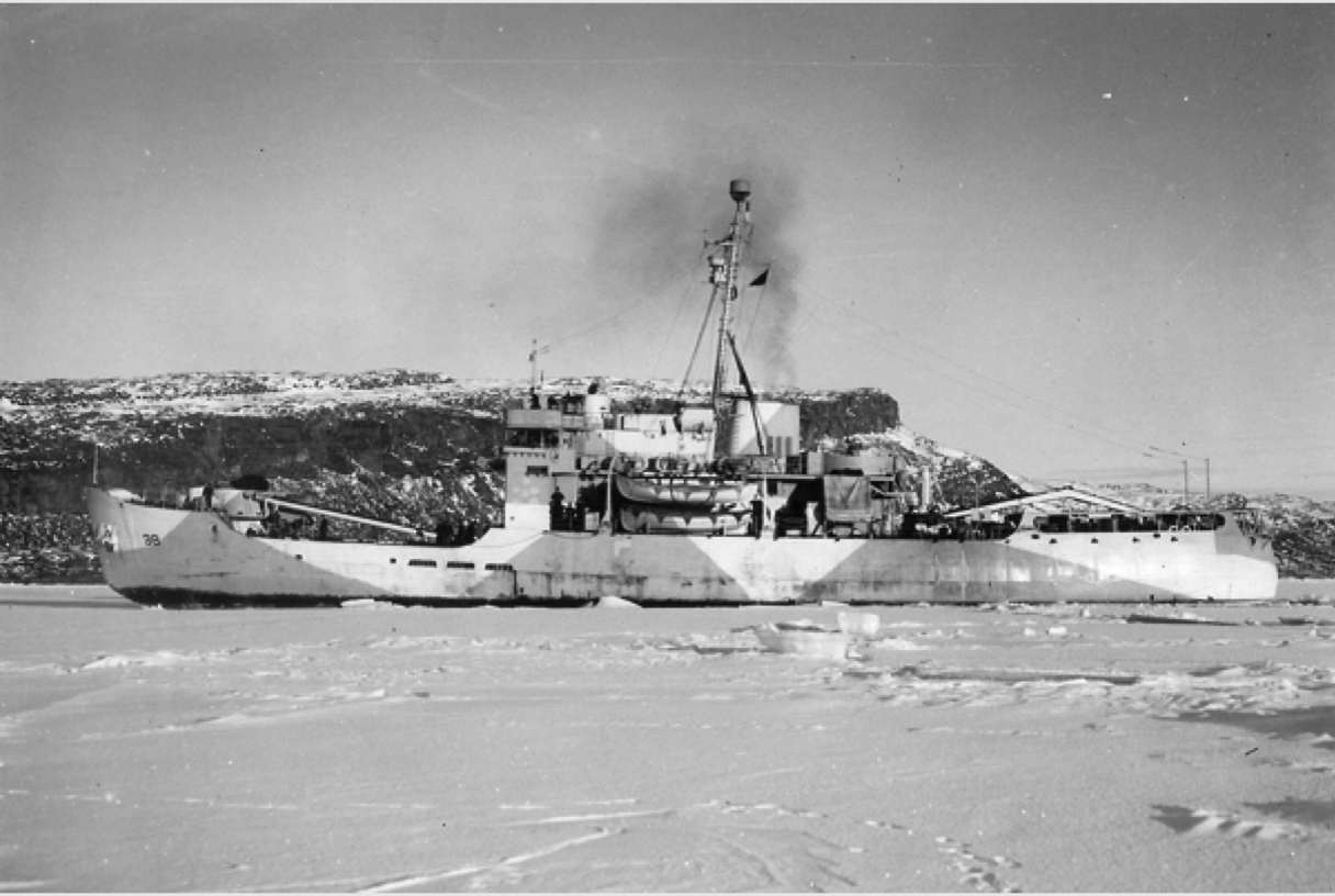
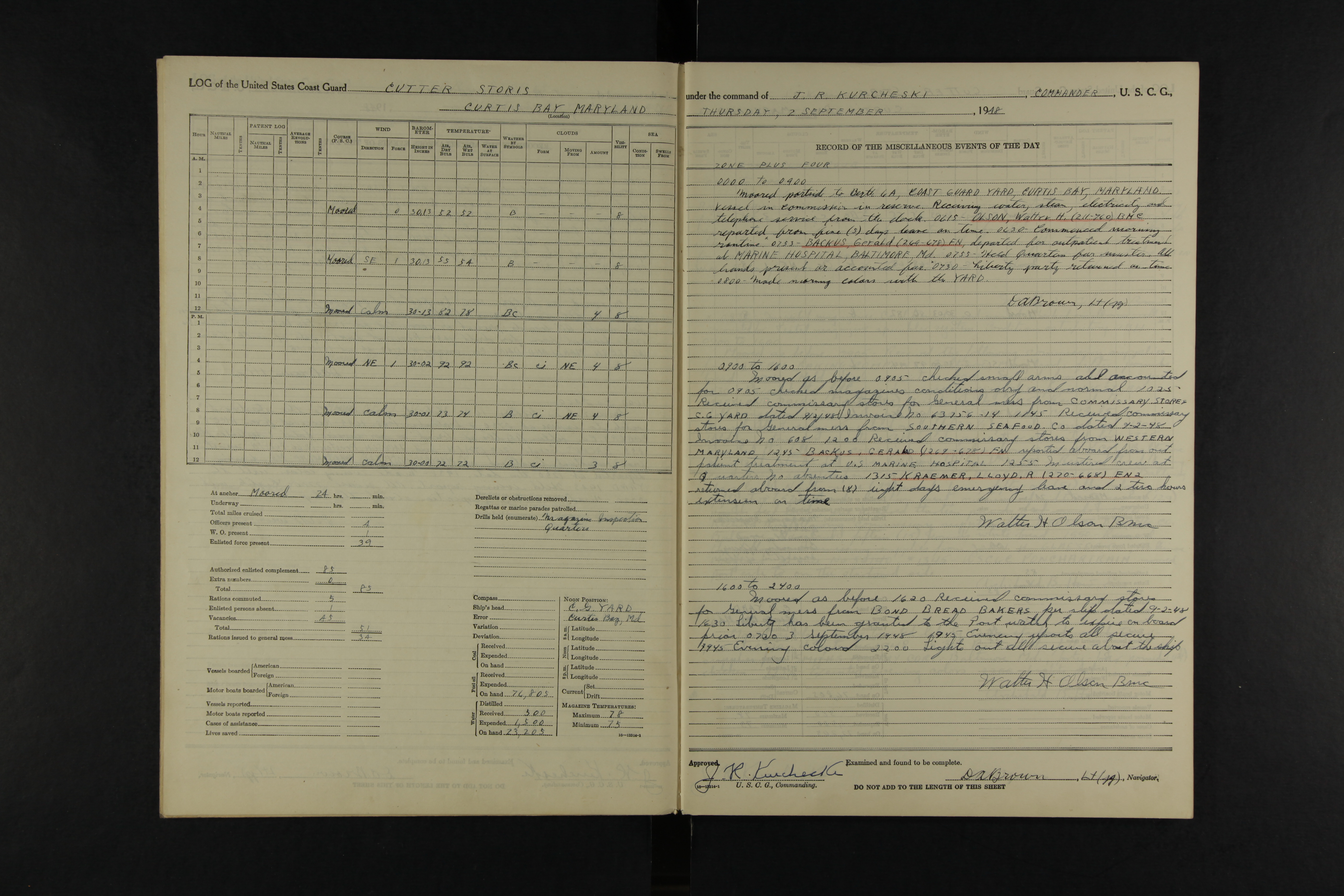
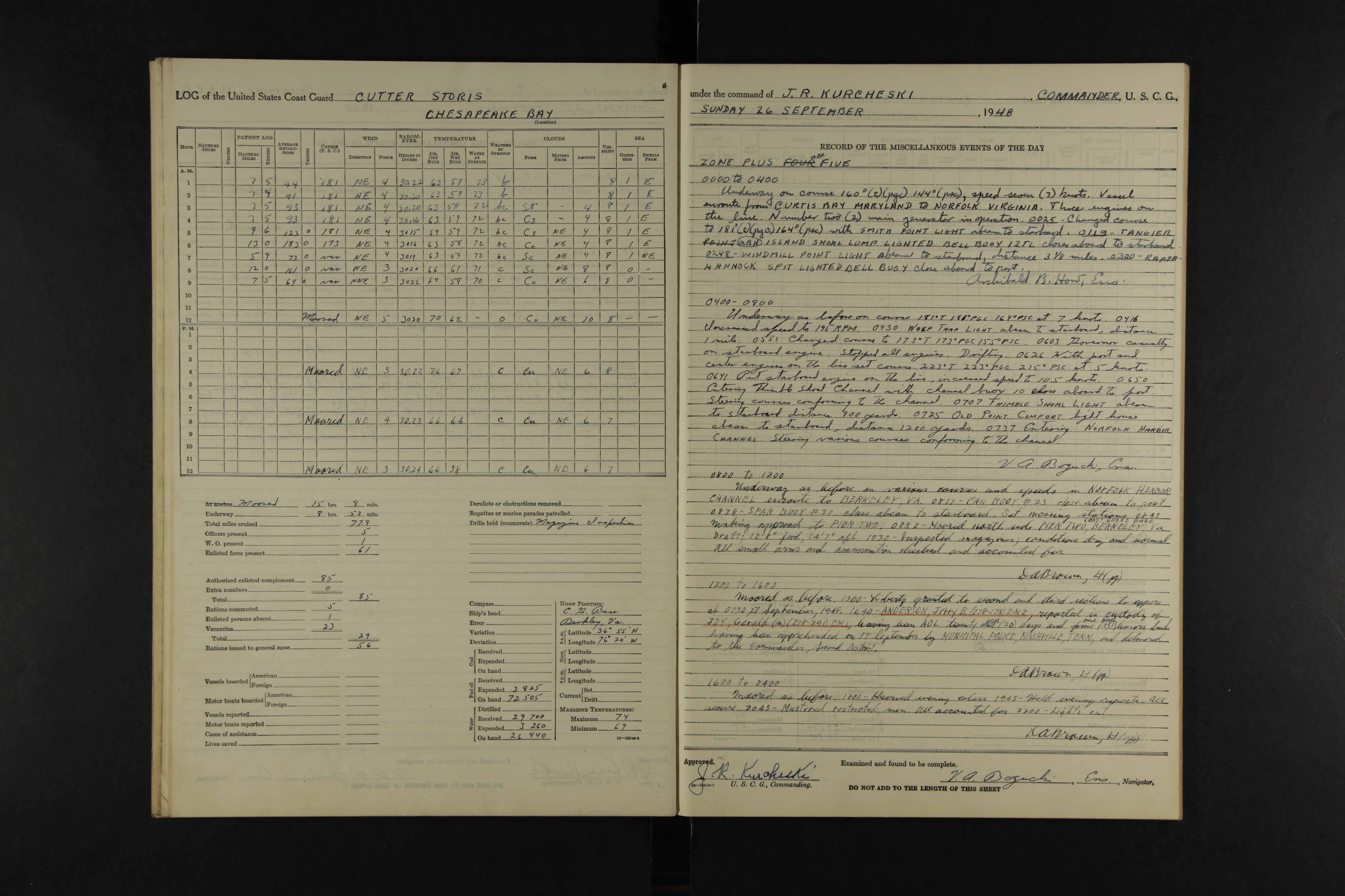
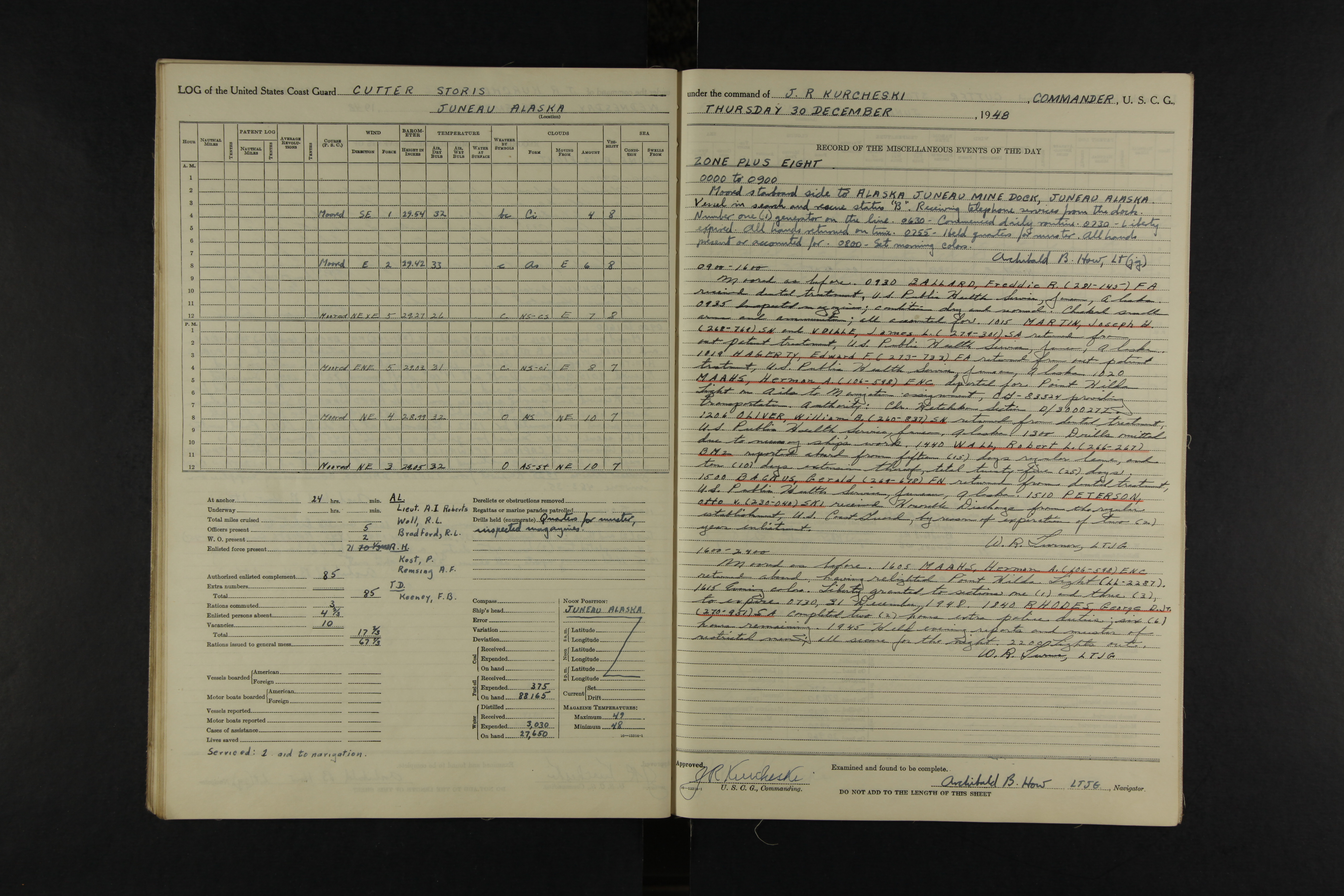
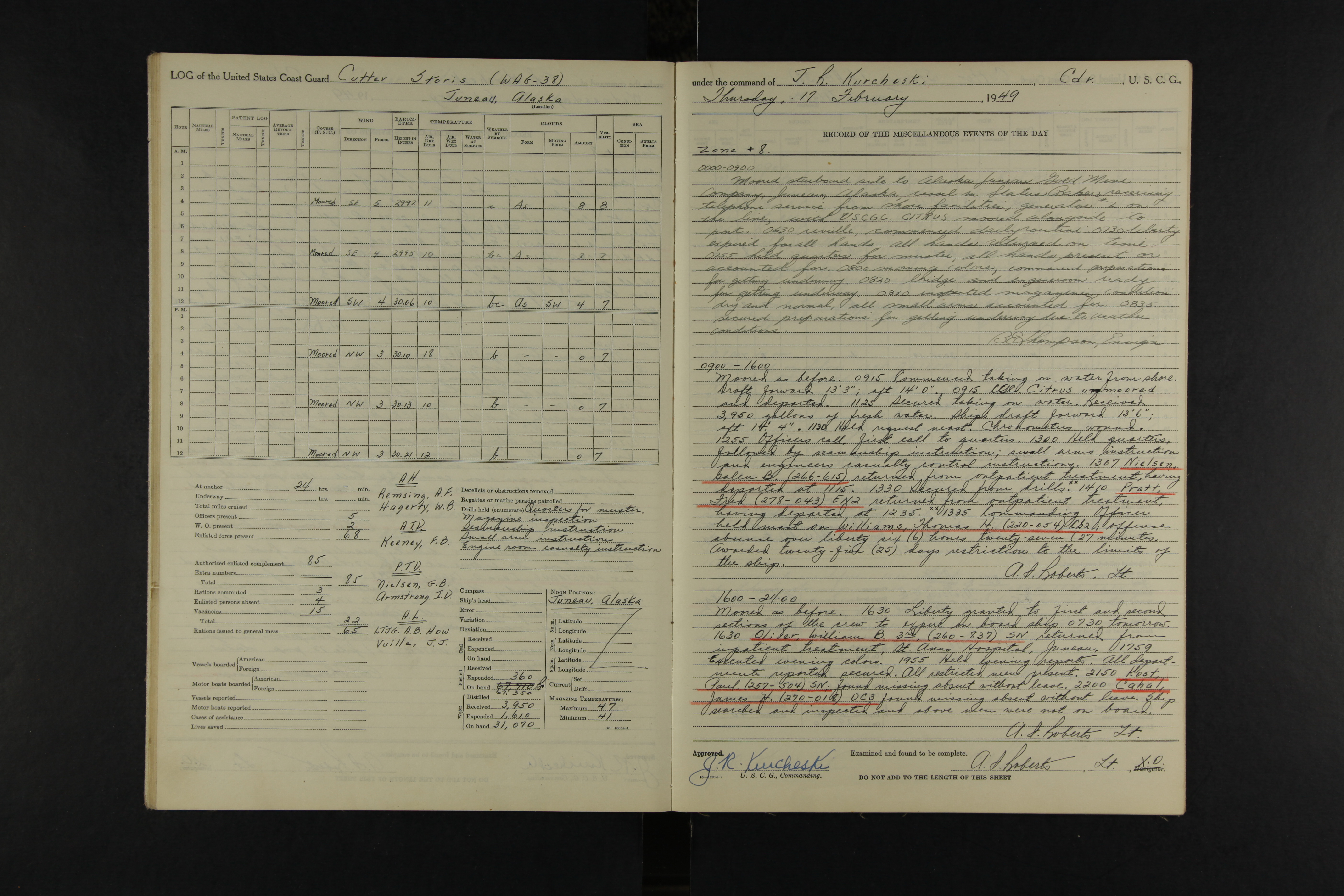