Naval History Homepage and Site Search
Naval History Homepage and Site Search
|
||||||||
|
||||||||
|
Old Sloop Launched 6.8.95 Devonport DY. 1050 tons, 210(oa), 185(pp)x32x11ft. TE 1400ihp, 13.5kts. Armament: 6-4in, 4-3pdr. Crew: 106. Based at Esquimalt, near Vancouver 1914-19, harbour service from 1915. Sold 11.4.19 as mercantile. (British Warships 1914-1919) |
||||||||
|
||||||||
|
Notes: 1. Latitude/longitude, including for days in port, show representative decimal positions for each day, as calculated by the Old Weather project's analysis program. As such, they differ by varying amounts from the positions recorded, usually at noon, in the log pages. In addition, some latitudes/longitudes have been amended in edited logs for errors in the logs, for errors in identifying locations by the analysis program, or simply for greater accuracy. In all cases, refer to the log-page scans for the positions as originally recorded. Not all log pages contain this information and the ships' positions have therefore often been estimated. 2. Full account of any day is available by clicking on the link above that day. Groups of links refer to log book covers and introductory information; some may be blank. |
||||||||
|
THE VOYAGES OF HMS ALGERINE 1914 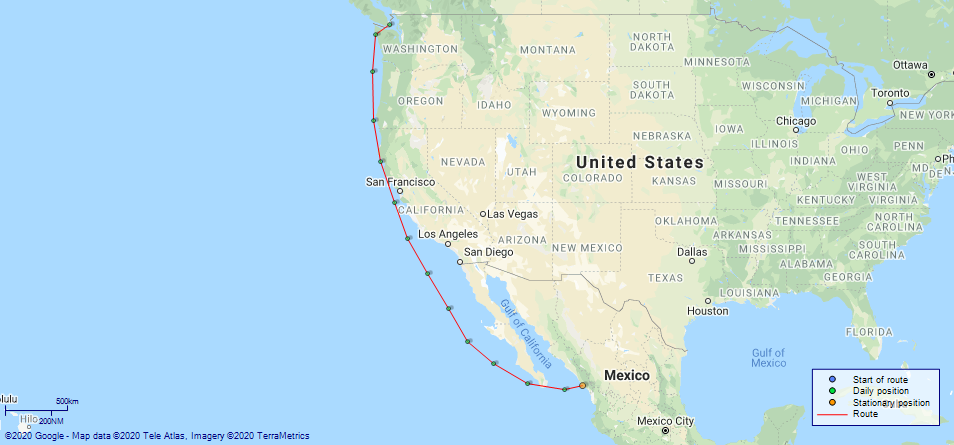
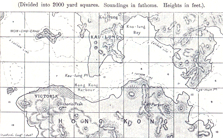
(Maps prepared using Journey Plotter, developed by Maikel. The Plots can only be approximate. They are made by joining-up positions on successive days, and sometimes positions are not given. There will therefore be occasions when the ship appears to have travelled overland) LOGS FOR AUGUST 1914 4ef4f94be53e0a0c91004c3f: (https://s3.amazonaws.com:443/oldweather/ADM53-33338/001_0.jpg) 4ef4f94be53e0a0c91004c40: (https://s3.amazonaws.com:443/oldweather/ADM53-33338/001_1.jpg) 4ef4f94be53e0a0c91004c41: (https://s3.amazonaws.com:443/oldweather/ADM53-33338/002_0.jpg) 4ef4f94be53e0a0c91004c42: (https://s3.amazonaws.com:443/oldweather/ADM53-33338/002_1.jpg) 4ef4f94be53e0a0c91004c43: (https://s3.amazonaws.com:443/oldweather/ADM53-33338/003_0.jpg) 1 August 1914 Mazatlan Lat 23.18, Long -106.42 6.20am: USS Cleveland arrived 4.30pm: Shifted billet Anchor bearings: Creston Island Lighthouse N74W; Black Rock S54W 5.30pm: Prepared landing parties 4ef4f94be53e0a0c91004c44: (https://s3.amazonaws.com:443/oldweather/ADM53-33338/003_1.jpg) 2 August 1914 Mazatlan Lat 23.18, Long -106.42 6.00am: German cruiser Leipzig discharged refugees 6.20am: Weighed and proceeded to US fleet 7.30am: Leipzig sailed with SS Citriana steaming W 11.00am: Proceeded alongside US collier Saturn Anchor bearings: Cliff Park S36W; Jacoba Bluff N67E 1.00pm: Commenced coaling 8.40pm: Finished coaling 9.10pm: Slipped 9.40pm: Anchored close to US flagship 4ef4f94be53e0a0c91004c45: (https://s3.amazonaws.com:443/oldweather/ADM53-33338/004_0.jpg) 3 August 1914 Mazatlan Lat 22.8, Long -108.0 [Estimated] 1.50am: Shortened in; weighed and proceeded SSW 6.00am: Unbent square sails, struck topgallant and topsail yards 9.00am: Struck lower yard; housed top masts and prepared ship for battle 6.00pm: Darkened ship; war routine 4ef4f94be53e0a0c91004c46: (https://s3.amazonaws.com:443/oldweather/ADM53-33338/004_1.jpg) 4 August 1914 Mazatlan to Esquimalt Lat 23.35, Long -111.23 8.50am: Streamed patent log 4ef4f94ce53e0a0c91004c47: (https://s3.amazonaws.com:443/oldweather/ADM53-33338/005_0.jpg) 5 August 1914 Mazatlan to Esquimalt Lat 24.90, Long -114.22 4ef4f94ce53e0a0c91004c48: (https://s3.amazonaws.com:443/oldweather/ADM53-33338/005_1.jpg) 6 August 1914 Mazatlan to Esquimalt Lat 26.67, Long -116.57 7.00pm: Darkened ship; war routine 4ef4f94ce53e0a0c91004c49: (https://s3.amazonaws.com:443/oldweather/ADM53-33338/006_0.jpg) 7 August 1914 Mazatlan to Esquimalt Lat 29.23, Long -118.20 6.55am: Sighted Guadalupe Island N53W 4ef4f94ce53e0a0c91004c4a: (https://s3.amazonaws.com:443/oldweather/ADM53-33338/006_1.jpg) 8 August 1914 Mazatlan to Esquimalt Lat 31.90, Long -120.03 6.45am: Sighted Guadalupe Island N53W 9.00pm: Darkened ship; passed steamer heading N 4ef4f94ce53e0a0c91004c4b: (https://s3.amazonaws.com:443/oldweather/ADM53-33338/007_0.jpg) 9 August 1914 Mazatlan to Esquimalt Lat 34.47, Long -121.78 4ef4f94ce53e0a0c91004c4c: (https://s3.amazonaws.com:443/oldweather/ADM53-33338/007_1.jpg) 10 August 1914 Mazatlan to Esquimalt Lat 37.0, Long -123.0 [Estimated] 4ef4f94ce53e0a0c91004c4d: (https://s3.amazonaws.com:443/oldweather/ADM53-33338/008_0.jpg) 11 August 1914 Mazatlan to Esquimalt Lat 39.83, Long -124.18 5.12pm: Stopped and communicated with USS Beaver and informed of declaration of war 5.40pm: Resumed to N37W 4ef4f94ce53e0a0c91004c4e: (https://s3.amazonaws.com:443/oldweather/ADM53-33338/008_1.jpg) 12 August 1914 Mazatlan to Esquimalt Lat 42.58, Long -124.83 2.00am: Sounding every half hour 10.00am: Lost overboard by accident 1 rotator for patent log 4ef4f94ce53e0a0c91004c4f: (https://s3.amazonaws.com:443/oldweather/ADM53-33338/009_0.jpg) 13 August 1914 Mazatlan to Esquimalt Lat 45.63, Long -124.90 2.00pm: Stopped and communicated with SS Falcon USA 4ef4f94ce53e0a0c91004c50: (https://s3.amazonaws.com:443/oldweather/ADM53-33338/009_1.jpg) 14 August 1914 Mazatlan to Esquimalt Lat 47.87, Long -124.62 4.50am: Stopped and communicated with Hospital SS Prince George 5.50am: Proceeded as required inshore 10.00am: Stopped ½ mile SW of Teahwhit Head; hands employed throwing all woodwork overboard and painting ship grey Disposed overboard: Steamboat no 413 Sailing cutter 26 feet 2 whalers 27 feet Skiff dinghy 16 feet Copper punt 8 feet Fire engine Pattern 2A Anchor and shackles cable Cabin furniture 12.15pm: Sighted SS River Forth (British) 12.30pm: SS River Forth closed and anchored 2.00pm: Let go port anchor in 19½ fathoms, veered to 5 shackles 3.00pm: Hands coaling ship by boats from SS River Forth 3.00pm: HMCS Rainbow closed 4.30pm: Slipped cable and proceeded NW 6.42pm: Umatilla Light Vessel abeam, ½ mile 8.38pm: Altered course as required for Jean de Fuca Straits and Esquimalt; HMCS Rainbow in company astern 4ef4f94ce53e0a0c91004c51: (https://s3.amazonaws.com:443/oldweather/ADM53-33338/010_0.jpg) 15 August 1914 Mazatlan to Esquimalt Lat 48.435, Long -123.430 12.30am: Sherringham Lighthouse 4½ miles on port beam 2.15am: Altered course as required for Esquimalt 4.30am: Made private signals and communicated with examining vessel 4.45am: Secured alongside HMCS Shearwater 9.00am: Hands employed packing arms and as required 10.00am: 1 rating discharged to hospital pm: Hands preparing to leave ship for HMS Niobe; HMS Algerine's boats not used 8.00pm: Hands left ship for HMS Niobe 4ef4f94ce53e0a0c91004c52: (https://s3.amazonaws.com:443/oldweather/ADM53-33338/010_1.jpg) 4ef4f94ce53e0a0c91004c53: (https://s3.amazonaws.com:443/oldweather/ADM53-33338/011_0.jpg) 4ef4f94ce53e0a0c91004c54: (https://s3.amazonaws.com:443/oldweather/ADM53-33338/011_1.jpg) 4ef4f94ce53e0a0c91004c55: (https://s3.amazonaws.com:443/oldweather/ADM53-33338/012_0.jpg 4ef4f94de53e0a0c91004c56: (https://s3.amazonaws.com:443/oldweather/ADM53-33338/012_1.jpg)
|
||||||||
|
Revised 23/08/2020 |
||||||||
 Project
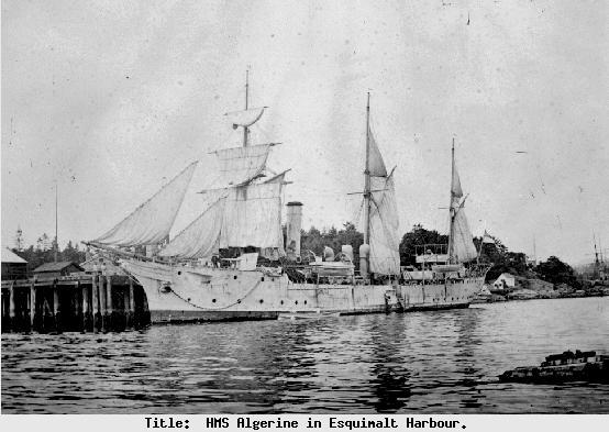