LOGS FOR JANUARY 1954
https://s3.amazonaws.com/NARAprodstorage/opastorage/live/56/5479/38547956/content/dc-metro/rg-026/559642/2017-01/storis-wmec-38-1954/storis-wmec-38-1954_0001.JPG
Front of log book
https://s3.amazonaws.com/NARAprodstorage/opastorage/live/56/5479/38547956/content/dc-metro/rg-026/559642/2017-01/storis-wmec-38-1954/storis-wmec-38-1954_0002.JPG
Inside Title page
https://s3.amazonaws.com/NARAprodstorage/opastorage/live/56/5479/38547956/content/dc-metro/rg-026/559642/2017-01/storis-wmec-38-1954/storis-wmec-38-1954_0003.JPG
Officer list
https://s3.amazonaws.com/NARAprodstorage/opastorage/live/56/5479/38547956/content/dc-metro/rg-026/559642/2017-01/storis-wmec-38-1954/storis-wmec-38-1954_0004.JPG
Log book instructions
https://s3.amazonaws.com/NARAprodstorage/opastorage/live/56/5479/38547956/content/dc-metro/rg-026/559642/2017-01/storis-wmec-38-1954/storis-wmec-38-1954_0005.JPG
1 January 1954
At/From ???
Lat 58.29, Long -134.4
Noon: U.S. GOV'T DOCK JUNEAU ALASKA
https://s3.amazonaws.com/NARAprodstorage/opastorage/live/56/5479/38547956/content/dc-metro/rg-026/559642/2017-01/storis-wmec-38-1954/storis-wmec-38-1954_0006.JPG
2 January 1954
At/From ???
Lat 58.29, Long -134.4
Noon: U.S. GOV'T DOCK JUNEAU ALASKA
https://s3.amazonaws.com/NARAprodstorage/opastorage/live/56/5479/38547956/content/dc-metro/rg-026/559642/2017-01/storis-wmec-38-1954/storis-wmec-38-1954_0007.JPG
3 January 1954
At/From ???
Lat 58.29, Long -134.4
Noon: U.S. GOV'T DOCK JUNEAU ALASKA
https://s3.amazonaws.com/NARAprodstorage/opastorage/live/56/5479/38547956/content/dc-metro/rg-026/559642/2017-01/storis-wmec-38-1954/storis-wmec-38-1954_0008.JPG
4 January 1954
At/From ???
Lat 58.29, Long -134.4
Noon: U.S. GOV'T DOCK JUNEAU ALASKA
https://s3.amazonaws.com/NARAprodstorage/opastorage/live/56/5479/38547956/content/dc-metro/rg-026/559642/2017-01/storis-wmec-38-1954/storis-wmec-38-1954_0009.JPG
5 January 1954
At/From ???
Lat 58.29, Long -134.4
21.06: Got underway
Noon: U.S. GOV'T DOCK JUNEAU ALASKA
23.34: Grand Island light bearing 081'T, 1300 yards
https://s3.amazonaws.com/NARAprodstorage/opastorage/live/56/5479/38547956/content/dc-metro/rg-026/559642/2017-01/storis-wmec-38-1954/storis-wmec-38-1954_0010.JPG
https://s3.amazonaws.com/NARAprodstorage/opastorage/live/56/5479/38547956/content/dc-metro/rg-026/559642/2017-01/storis-wmec-38-1954/storis-wmec-38-1954_0011.JPG
6 January 1954
At/From ???
Lat 56.47, Long -132.8
15.19: Set course and speed
14.46: Standing ~ of LINCOLN ROCK L/S
20.40: Moored Portside to U.S. Coast Guard Dock, Base Ketchikan,
Alaska (BERTH 3)
Grand Island brg 81 degs. True 1300 yards at 2334.
01.37: Midway Island light bearing 021'T distant 4,000 yards
02.39: Pt Hugh light abeam to starboard distant 3,300 yards
Windham Bay Entrance Light brg E True 6 miles
0430 : Five Finger light abeam to starboard distance 0.5 mile.
Cape Strait Light brg 180 degs. True 400 yards at 0720.
Northern Entrance
11.22: Midway Island abeam to port, 1800 yards 1138 : Point Alexander
Light bearing 343'T, 4800 yards.
Point Alexander brg 343 degs. True 4800 yards at 1138.
16.50: Narrow Point Light bearing 270', distance 3000 yards
17.58: Ship Island light bearing 090'T, distance 1500 yards
Ship Island Light brg 90 degs. True 1500 yards
19.52: Lewis Reef Light abeam to starboard, distance 200 yards 19.41:
Channel Island Light abeam to port distance 200 yards. 19.05: Guard
Island Light abeam to starboard, distance 900 yards
https://s3.amazonaws.com/NARAprodstorage/opastorage/live/56/5479/38547956/content/dc-metro/rg-026/559642/2017-01/storis-wmec-38-1954/storis-wmec-38-1954_0012.JPG
7 January 1954
At/From ???
Lat 55.34, Long -131.65
Noon: Berth 3 C.G. Base Ketchikan Alaska
https://s3.amazonaws.com/NARAprodstorage/opastorage/live/56/5479/38547956/content/dc-metro/rg-026/559642/2017-01/storis-wmec-38-1954/storis-wmec-38-1954_0013.JPG
https://s3.amazonaws.com/NARAprodstorage/opastorage/live/56/5479/38547956/content/dc-metro/rg-026/559642/2017-01/storis-wmec-38-1954/storis-wmec-38-1954_0014.JPG
8 January 1954
At/From ???
Lat 55.74, Long -132.42
09.01: Underway
Rosa Reef Light brg W True 300 yards at 0955.
Narrow Point Light brg 270 degs. True 800 yards at 1217.
Key Reef brg 350 degs. True 3400 yards at 1612.
Bushy Island Light brg 270 degs. True 400 yards at 1655.
Point Colypoys brg 179 degs. True 400 yards at 1735.
Helm Rock brg 180 degs. True 1 mile at 1841.
Nothing found brg 081 degs. True 800 yards at 1932.
21.13: Cape Decision Light abeam to starboard, 900 yards 21.10:
Spanish Island Light abeam to port, 1300 yards
22.15: Point Crowley Light abeam to starboard, 7700 yards
23.50: Point Harris abeam to starboard, 7000 yards
https://s3.amazonaws.com/NARAprodstorage/opastorage/live/56/5479/38547956/content/dc-metro/rg-026/559642/2017-01/storis-wmec-38-1954/storis-wmec-38-1954_0015.JPG
9 January 1954
At/From ???
Lat 57.87, Long -133.94
15.00: Moored, Government Dock, Juneau, Alaska
08.40: Underway on v/c/s Standing off Five Finger Light Station.
09.20: Set course
02.25: Cornwallis Point light abeam to starboard dist. 7,200 yards
03.29: Turnabout Island light bearing 090'T dist 8000 yards
Position 3000 yards S True of South East Five Fingers Light
Noon: STEPHENS PASSAGE
https://s3.amazonaws.com/NARAprodstorage/opastorage/live/56/5479/38547956/content/dc-metro/rg-026/559642/2017-01/storis-wmec-38-1954/storis-wmec-38-1954_0016.JPG
10 January 1954
At/From ???
Lat 58.29, Long -134.4
Noon: U.S. GOV'T DOCK JUNEAU ALASKA
https://s3.amazonaws.com/NARAprodstorage/opastorage/live/56/5479/38547956/content/dc-metro/rg-026/559642/2017-01/storis-wmec-38-1954/storis-wmec-38-1954_0017.JPG
11 January 1954
At/From ???
Lat 58.29, Long -134.4
Noon: U.S. GOV'T DOCK JUNEAU ALASKA
https://s3.amazonaws.com/NARAprodstorage/opastorage/live/56/5479/38547956/content/dc-metro/rg-026/559642/2017-01/storis-wmec-38-1954/storis-wmec-38-1954_0018.JPG
12 January 1954
At/From ???
Lat 58.29, Long -134.4
Noon: U.S. GOV'T DOCK JUNEAU ALASKA
https://s3.amazonaws.com/NARAprodstorage/opastorage/live/56/5479/38547956/content/dc-metro/rg-026/559642/2017-01/storis-wmec-38-1954/storis-wmec-38-1954_0019.JPG
https://s3.amazonaws.com/NARAprodstorage/opastorage/live/56/5479/38547956/content/dc-metro/rg-026/559642/2017-01/storis-wmec-38-1954/storis-wmec-38-1954_0020.JPG
13 January 1954
At/From ???
Lat 58.41, Long -134.96
08.29: Anchored in Gastineau Channel
08.02: Underway
09.02: Anchor aweigh
22.08: Anchored south of Benjamin Island
Inner Point brg 27 degs. True 800 yards at 1020.
Standing off Point Retreat Lightstation
13.31: Hump Island bearing 090'T, 3400 yards
15.43: Sherman Rock Lighted Buoy #2 abeam to starboard 2000 yards
Standing off Eldred Rock
1910 underway
21.25: Vanderbilt Reef Light abeam to starboard, 1200 yards
https://s3.amazonaws.com/NARAprodstorage/opastorage/live/56/5479/38547956/content/dc-metro/rg-026/559642/2017-01/storis-wmec-38-1954/storis-wmec-38-1954_0021.JPG
14 January 1954
At/From ???
Lat 58.45, Long -135
08.00: Underway
00.00: Sentinel island light - 262'T, Poundstone Rock lighted bell
buoy #1 - 222'T and 160 foot islet - 310'T
Standing off Sentinel Island
0944 underway
Noon: POINT RETREAT LIGHT STA.
14.14: Naked Island Light Abeam to port, 2900 yards 14.38: Rocky Is.
Light bearing 314', 3600 yards
Rock Island brg 314 degs. True 3600 yards at 1438.
16.52: Point Adolphus bearing 184'T, 2600 yards
17.44: Lemesurier Island Light abeam to port 2300 yards
19.30: Cape Spencer light bearing 000'T, 5200yds.
https://s3.amazonaws.com/NARAprodstorage/opastorage/live/56/5479/38547956/content/dc-metro/rg-026/559642/2017-01/storis-wmec-38-1954/storis-wmec-38-1954_0022.JPG
15 January 1954
At/From ???
Lat 59.55, Long -139.75
16.03: Underway on various courses and speeds standing out of Yakutat
enroute Cape Spencer Light Station.
09.23: Moored port side to cannery dock, Yakutat, Alaska
06.55: OCEAN CAPE LIGHT abeam to starboard, distance 6200 yards.
Noon: CANNERY DOCK YAKUTAT ALASKA
Yakutat Lighted Whistle Buoy #2 brg 150 degs. True 50 yards at 1707.
https://s3.amazonaws.com/NARAprodstorage/opastorage/live/56/5479/38547956/content/dc-metro/rg-026/559642/2017-01/storis-wmec-38-1954/storis-wmec-38-1954_0023.JPG
https://s3.amazonaws.com/NARAprodstorage/opastorage/live/56/5479/38547956/content/dc-metro/rg-026/559642/2017-01/storis-wmec-38-1954/storis-wmec-38-1954_0024.JPG
16 January 1954
At/From ???
Lat 58.2, Long -136.64
19.05: Anchored in Icy Passage off Gustavus Airport
21.45: Drifting 900 yards off Sisters Island
Libby Island brg 36 degs. True 5 miles at 0630.
Standing off Cape Spencer L.S.
Noon: CAPE SPENCER LT STA
1621 underway
17.08: North Inian Pass Light abeam to starboard 1200 yards
18.10: Lemesurier Island Light abeam to starboard 1800 yards
2235 underway
Rock Island brg 270 degs. True 2800 yards at 2330.
https://s3.amazonaws.com/NARAprodstorage/opastorage/live/56/5479/38547956/content/dc-metro/rg-026/559642/2017-01/storis-wmec-38-1954/storis-wmec-38-1954_0025.JPG
https://s3.amazonaws.com/NARAprodstorage/opastorage/live/56/5479/38547956/content/dc-metro/rg-026/559642/2017-01/storis-wmec-38-1954/storis-wmec-38-1954_0026.JPG
17 January 1954
At/From ???
Lat 58.29, Long -134.4
04.36: Anchor aweigh, proceeding to Juneau
02.28: Anchored TEE HARBOR
09.03: Moored starboard side to U.S.Government Dock, Juneau, Alaska
01.39: Favorite Reef bearing 078' PGC, range 1100 yards 01.00: Pt
Retreat bearing 091' PGC, range 2900 yards 01.11: Pt. Retreat bearing
228' PGC, range 3000 yards
06.25: Point Hilda Light bearing 000'T distance 2000 yards
07.30: Marmion Island Light bearing 000'T distance 2600 yards
Noon: U.S. GOV'T DOCK JUNEAU ALASKA
https://s3.amazonaws.com/NARAprodstorage/opastorage/live/56/5479/38547956/content/dc-metro/rg-026/559642/2017-01/storis-wmec-38-1954/storis-wmec-38-1954_0027.JPG
18 January 1954
At/From ???
Lat 58.29, Long -134.4
Noon: U.S. GOV'T DOCK JUNEAU ALASKA
https://s3.amazonaws.com/NARAprodstorage/opastorage/live/56/5479/38547956/content/dc-metro/rg-026/559642/2017-01/storis-wmec-38-1954/storis-wmec-38-1954_0028.JPG
19 January 1954
At/From ???
Lat 58.29, Long -134.4
Noon: U.S. GOV'T DOCK JUNEAU ALASKA
https://s3.amazonaws.com/NARAprodstorage/opastorage/live/56/5479/38547956/content/dc-metro/rg-026/559642/2017-01/storis-wmec-38-1954/storis-wmec-38-1954_0029.JPG
20 January 1954
At/From ???
Lat 58.29, Long -134.4
Noon: U.S. GOV'T DOCK JUNEAU ALASKA
https://s3.amazonaws.com/NARAprodstorage/opastorage/live/56/5479/38547956/content/dc-metro/rg-026/559642/2017-01/storis-wmec-38-1954/storis-wmec-38-1954_0030.JPG
21 January 1954
At/From ???
Lat 58.29, Long -134.4
Noon: U.S. GOV'T DOCK JUNEAU ALASKA
https://s3.amazonaws.com/NARAprodstorage/opastorage/live/56/5479/38547956/content/dc-metro/rg-026/559642/2017-01/storis-wmec-38-1954/storis-wmec-38-1954_0031.JPG
22 January 1954
At/From ???
Lat 58.29, Long -134.4
Noon: U.S. GOV'T DOCK JUNEAU ALASKA
https://s3.amazonaws.com/NARAprodstorage/opastorage/live/56/5479/38547956/content/dc-metro/rg-026/559642/2017-01/storis-wmec-38-1954/storis-wmec-38-1954_0032.JPG
23 January 1954
At/From ???
Lat 58.29, Long -134.4
Noon: U.S. GOV'T DOCK JUNEAU ALASKA
https://s3.amazonaws.com/NARAprodstorage/opastorage/live/56/5479/38547956/content/dc-metro/rg-026/559642/2017-01/storis-wmec-38-1954/storis-wmec-38-1954_0033.JPG
24 January 1954
At/From ???
Lat 58.29, Long -134.4
Noon: U.S. GOV'T DOCK JUNEAU ALASKA
https://s3.amazonaws.com/NARAprodstorage/opastorage/live/56/5479/38547956/content/dc-metro/rg-026/559642/2017-01/storis-wmec-38-1954/storis-wmec-38-1954_0034.JPG
25 January 1954
At/From ???
Lat 58.29, Long -134.4
Noon: U.S. GOV'T DOCK JUNEAU ALASKA
https://s3.amazonaws.com/NARAprodstorage/opastorage/live/56/5479/38547956/content/dc-metro/rg-026/559642/2017-01/storis-wmec-38-1954/storis-wmec-38-1954_0035.JPG
26 January 1954
At/From ???
Lat 58.29, Long -134.4
Noon: U.S. GOV'T DOCK JUNEAU ALASKA
https://s3.amazonaws.com/NARAprodstorage/opastorage/live/56/5479/38547956/content/dc-metro/rg-026/559642/2017-01/storis-wmec-38-1954/storis-wmec-38-1954_0036.JPG
27 January 1954
At/From ???
Lat 58.29, Long -134.4
Noon: U.S. GOV'T DOCK JUNEAU ALASKA
https://s3.amazonaws.com/NARAprodstorage/opastorage/live/56/5479/38547956/content/dc-metro/rg-026/559642/2017-01/storis-wmec-38-1954/storis-wmec-38-1954_0037.JPG
28 January 1954
At/From ???
Lat 58.29, Long -134.4
Noon: U.S. GOV'T DOCK JUNEAU ALASKA
https://s3.amazonaws.com/NARAprodstorage/opastorage/live/56/5479/38547956/content/dc-metro/rg-026/559642/2017-01/storis-wmec-38-1954/storis-wmec-38-1954_0038.JPG
29 January 1954
At/From ???
Lat 58.29, Long -134.4
Noon: U.S. GOV'T DOCK JUNEAU ALASKA
https://s3.amazonaws.com/NARAprodstorage/opastorage/live/56/5479/38547956/content/dc-metro/rg-026/559642/2017-01/storis-wmec-38-1954/storis-wmec-38-1954_0039.JPG
30 January 1954
At/From ???
Lat 58.29, Long -134.4
Noon: U.S. GOV'T DOCK JUNEAU ALASKA
https://s3.amazonaws.com/NARAprodstorage/opastorage/live/56/5479/38547956/content/dc-metro/rg-026/559642/2017-01/storis-wmec-38-1954/storis-wmec-38-1954_0040.JPG
31 January 1954
At/From ???
Lat 58.29, Long -134.4
21.55: Underway on various courses and speeds standing into gastineau
channel.
Noon: U.S. GOV'T DOCK JUNEAU ALASKA
22.47: Marmion Island light bearing 250'T, 1300 yards 22.55: Marmion
Island light bearing 005'T, 2000 yards
https://s3.amazonaws.com/NARAprodstorage/opastorage/live/56/5479/38547956/content/dc-metro/rg-026/559642/2017-01/storis-wmec-38-1954/storis-wmec-38-1954_0041.JPG
Note to use new log
https://s3.amazonaws.com/NARAprodstorage/opastorage/live/56/5479/38547956/content/dc-metro/rg-026/559642/2017-01/storis-wmec-38-1954/storis-wmec-38-1954_0042.JPG
blank page
LOGS FOR FEBRUARY 1954
https://s3.amazonaws.com/NARAprodstorage/opastorage/live/56/5479/38547956/content/dc-metro/rg-026/559642/2017-01/storis-wmec-38-1954/storis-wmec-38-1954_0043.JPG
Front of Log Book
https://s3.amazonaws.com/NARAprodstorage/opastorage/live/56/5479/38547956/content/dc-metro/rg-026/559642/2017-01/storis-wmec-38-1954/storis-wmec-38-1954_0044.JPG
Inside Title page
https://s3.amazonaws.com/NARAprodstorage/opastorage/live/56/5479/38547956/content/dc-metro/rg-026/559642/2017-01/storis-wmec-38-1954/storis-wmec-38-1954_0045.JPG
Officer List
https://s3.amazonaws.com/NARAprodstorage/opastorage/live/56/5479/38547956/content/dc-metro/rg-026/559642/2017-01/storis-wmec-38-1954/storis-wmec-38-1954_0046.JPG
Log Book Instructions
https://s3.amazonaws.com/NARAprodstorage/opastorage/live/56/5479/38547956/content/dc-metro/rg-026/559642/2017-01/storis-wmec-38-1954/storis-wmec-38-1954_0047.JPG
https://s3.amazonaws.com/NARAprodstorage/opastorage/live/56/5479/38547956/content/dc-metro/rg-026/559642/2017-01/storis-wmec-38-1954/storis-wmec-38-1954_0048.JPG
1 February 1954
At/From ???
Lat 58.26, Long -135
04.56: Drifting off Port Frederick awaiting daylight to service aids
to navigation.
07.25: Put centre main engine on the line. Set course
13.03: Anchored off Point Retreat
20.32: Anchored
17.32: Underway
Middle Point Light brg 090 degs. True 1 mile
01.59: Pt Retreat bearing 110'T distant 2,200 yards
03.03: Naked Island light abeam to port distant 2,600 yards
Porpoise Islands brg N True 8500 yards
08.47: off HOONAH, Alaska
09.55: off Spasski Island
11.35: Rocky Island bearing 306'PGC, distance 2900 yards
Noon: Lynn Canal
18.33: Naked Island light abeam to port distant 2,200 yards
19.15: Rocky Island light bearing 278'T range 2,600
21.55: Point Adolphus Light abeam to port, 2000 yards
22.32: true bearings: Gustavus Beacon 048.5', Porpoise Island Light
091' and Point Adolphus Light 117'. 22.32: Anchored
https://s3.amazonaws.com/NARAprodstorage/opastorage/live/56/5479/38547956/content/dc-metro/rg-026/559642/2017-01/storis-wmec-38-1954/storis-wmec-38-1954_0049.JPG
2 February 1954
At/From ???
Lat 57.85, Long -134.83
07.43: Anchor aweigh
00.00: Gustavus Aero Beacon 048'T, Porpoise Island Aero Beacon 091'T
and Point Adolphus light 117'T
09.45: Sisters Island light abeam to port range 2,000 yards
Point Agusta brg 270 degs. True 3000 yards at 1055.
Noon: CHATHAM STRAITS
Yasha Island brg 90 degs. True 6000 yards
21.30: Cape Ommaney light abeam to starboard distant 9,000 yards
22.40: Cape Decision light bearing 045'T, distant 4,000 yards
Cape Decision Lighthouse brg 45 degs. True 4000 yards at 2240.
https://s3.amazonaws.com/NARAprodstorage/opastorage/live/56/5479/38547956/content/dc-metro/rg-026/559642/2017-01/storis-wmec-38-1954/storis-wmec-38-1954_0050.JPG
3 February 1954
At/From ???
Lat 55.52, Long -132.06
14.41: Moored port side to berth #3, Coast GuardBase, Ketchikan,
Alaska.
00.42: Beauclers Island light abeam to port, Range 7,500 yards
01.29: Point Baker Anchorage Light bearing 150'T, Range 3,125 yards
02.50: Eye Opener Light bearing 242'T, Range 5,600 yards
04.00: Point Alexander bearing 326'T, distance 4500 yards 04.37: Two
Tree Island Light bearing 068'T, distance 6000 yards
05.10: Vark Island Light bearing 340'T distance 3300 yards
06.40: Steamer Point Light bearing 090'T, distance 4000 yards
07.30: Lincoln Rock Light bearing 090'T, distace 2200 yards
09.10: Narrow Point Light abeam to starboard, 3500 yards
Noon: CLARENCE STRAIT
13.00: Guard Island abeam to starboard 1200 yards
https://s3.amazonaws.com/NARAprodstorage/opastorage/live/56/5479/38547956/content/dc-metro/rg-026/559642/2017-01/storis-wmec-38-1954/storis-wmec-38-1954_0051.JPG
4 February 1954
At/From ???
Lat 55.34, Long -131.65
16.25: Underway on various courses and speeds standing into Tongass
Narrows
11.00: Underway on various coursesand speeds standing out of Womens
Bay
Noon: Berth #3, C.G.Base Ketchikan, Alaska
17.29: Rosa Reef Light abeam to Port, distance 800 yards 17.43:
Guard Island Light bearing 196'T, Range 1,000 yards
18.51: Ship Island Light bearing 085'T, Range 2,900 yards
2111 off Lincoln Rock Light Station
2246 uneerway
23.40: Steamer Point Light bearing 085'PGC, 5,000 yards
https://s3.amazonaws.com/NARAprodstorage/opastorage/live/56/5479/38547956/content/dc-metro/rg-026/559642/2017-01/storis-wmec-38-1954/storis-wmec-38-1954_0096.JPG
4 March 1954
At/From ???
Lat 57.7, Long -152.26
11.00: Underway on various coursesand speeds standing out of Womens
Bay
12.15: REFUGE ISLAND Day beacon bearing 318'T, Range 3000 yds Noon:
WOMEN'S BAY
https://s3.amazonaws.com/NARAprodstorage/opastorage/live/56/5479/38547956/content/dc-metro/rg-026/559642/2017-01/storis-wmec-38-1954/storis-wmec-38-1954_0052.JPG
https://s3.amazonaws.com/NARAprodstorage/opastorage/live/56/5479/38547956/content/dc-metro/rg-026/559642/2017-01/storis-wmec-38-1954/storis-wmec-38-1954_0053.JPG
5 February 1954
At/From ???
Lat 56.83, Long -132.93
12.43: Underway on various courses and speeds
08.02: Underway standing into Wrangell Narrows
11.55: Stopped Centre Main Engine
01.45: Anchored in Sumner Strait
Round Point brg 294 degs. True 1 mile at 0004.
Two Tree Island Light brg 68 degs. True 5900 yards at 0111.
He heads N and comes back to Buoy #63.
13.22: Beacon Point Day beacon bearing 270'T, 1800 yards
The Five Fingers
18.35: Pt Hugh bearing 270'T range 5000 yds
19.32: Midway Island Light bearing 010'T range 4600 yds
21.23: Grave Point bearing 077'T, range 900 Yds
22.05: Point Arden bearing 216'T, range 2,900 Yds
23.47: Middle Point bearing 076'T, Range 1300 Yds 23.15: Hilda Point
Light bearing 000'T, Range 2000 Yds 23.31: Inner Point bearing 000'T
+ PGC, Range 900 Yds
https://s3.amazonaws.com/NARAprodstorage/opastorage/live/56/5479/38547956/content/dc-metro/rg-026/559642/2017-01/storis-wmec-38-1954/storis-wmec-38-1954_0054.JPG
https://s3.amazonaws.com/NARAprodstorage/opastorage/live/56/5479/38547956/content/dc-metro/rg-026/559642/2017-01/storis-wmec-38-1954/storis-wmec-38-1954_0055.JPG
6 February 1954
At/From ???
Lat 58.64, Long -135.04
04.41: Stopped Drifting 2 miles south of Eldred Rock Light Station.
Using engines to maintain position.
10.04: Underway
16.14: Drifting off Point Retreat
18.02: Drifting alongside unattended drifting fish traps
16.47: All three main engines on the line
00.55: Favorite Reef bearing 090'PGC+T, 1100 yards
01.35: Point Retreat bearing 130'PGC+T, 6000 yards 01.13: Point
Retreat bearing 226'PGC+T, 2600 yards
02.10: Little Island bearing 090'T, 2300 yards
Position 2 miles S True of Elred Rock
Holding position
Sherman Rock brg 64 degs. True 1100 yards at 1048.
Vanderbilt Reef brg 270 degs. True 800 yards at 1217.
15.00: Vanderbilt Reef bearing 302'T, Range 6,200Yds
17.05: Naked Island light bearing 043'PGC, 3000 yards
https://s3.amazonaws.com/NARAprodstorage/opastorage/live/56/5479/38547956/content/dc-metro/rg-026/559642/2017-01/storis-wmec-38-1954/storis-wmec-38-1954_0056.JPG
7 February 1954
At/From ???
Lat 57.88, Long -134.91
17.17: Anchored
22.58: Underway standing out of Fresh Water Bay
09.20: Underway enroute Fresh Water Bay
11.53: North Passage Point bearing 208'PGC, 4000 yards
12.58: North Passage Pt. bearing 295'T Range 2750 yards Noon: FRESH
WATER BAY
15.25: off Cedar Island
https://s3.amazonaws.com/NARAprodstorage/opastorage/live/56/5479/38547956/content/dc-metro/rg-026/559642/2017-01/storis-wmec-38-1954/storis-wmec-38-1954_0057.JPG
https://s3.amazonaws.com/NARAprodstorage/opastorage/live/56/5479/38547956/content/dc-metro/rg-026/559642/2017-01/storis-wmec-38-1954/storis-wmec-38-1954_0058.JPG
8 February 1954
At/From ???
Lat 58.31, Long -135.78
05.15: Stopped. Drifting 7,500 yards south of Point Gustavus
06.16: Set course
20.38: Underway
22.28: Anchored
15.18: Anchored
00.59: Point Augusta Light bearing 282'T, Range 4600 yard
04.48: Point Adolphus Light bearing 172'T, distance 2100 yards
07.30: North Union Pass Light bearing 180'T, distance 1600 yards
Drifting off Cape Spencer Light. 0950 underway 054 at 12 knots
11.25: Lemesurier Island Light bearing 190'PGC, 2500 yards
12.01: Point Augusta bearing 180'T, 2000 yards. This must be Point
Adolphus.
13.55: Rocky Island Light bearing 310'T, 4000 yards
21.36: Little Island Light bearing 245'T, Range 3000 yards
https://s3.amazonaws.com/NARAprodstorage/opastorage/live/56/5479/38547956/content/dc-metro/rg-026/559642/2017-01/storis-wmec-38-1954/storis-wmec-38-1954_0059.JPG
https://s3.amazonaws.com/NARAprodstorage/opastorage/live/56/5479/38547956/content/dc-metro/rg-026/559642/2017-01/storis-wmec-38-1954/storis-wmec-38-1954_0060.JPG
9 February 1954
At/From ???
Lat 58.47, Long -134.87
15.31: Moored Starboard Side to U.S. Government Dock, Juneau, Alaska
11.09: Underway enroute Juneau
00.00: Point Retreat Light - 192'T, Sentinel Island Light - 256'T,
Vanderbilt Reef Light - 304'T
12.12: Gull Island bearing 091'T Range 800 yards 12.32: Shelter
Island Light bearing 245'T, Range 1200 Yds Noon: SAGINAW CHANNEL
13.01: Portland Island Light bearing 090'T Range 1960 Yds
14.45: Marmion Light bearing 255'T, Range 2000 Yds. 14.02: Hilda
Point Light bearing 031'T, Range 2500 Yds.
https://s3.amazonaws.com/NARAprodstorage/opastorage/live/56/5479/38547956/content/dc-metro/rg-026/559642/2017-01/storis-wmec-38-1954/storis-wmec-38-1954_0061.JPG
10 February 1954
At/From ???
Lat 58.29, Long -134.4
Noon: U.S. GOV'T DOCK JUNEAU ALASKA
https://s3.amazonaws.com/NARAprodstorage/opastorage/live/56/5479/38547956/content/dc-metro/rg-026/559642/2017-01/storis-wmec-38-1954/storis-wmec-38-1954_0062.JPG
11 February 1954
At/From ???
Lat 58.29, Long -134.4
Noon: U.S. GOV'T DOCK JUNEAU ALASKA
https://s3.amazonaws.com/NARAprodstorage/opastorage/live/56/5479/38547956/content/dc-metro/rg-026/559642/2017-01/storis-wmec-38-1954/storis-wmec-38-1954_0063.JPG
12 February 1954
At/From ???
Lat 58.29, Long -134.4
Noon: U.S.GOV'T DOCK JUNEAU ALASKA
https://s3.amazonaws.com/NARAprodstorage/opastorage/live/56/5479/38547956/content/dc-metro/rg-026/559642/2017-01/storis-wmec-38-1954/storis-wmec-38-1954_0064.JPG
13 February 1954
At/From ???
Lat 58.29, Long -134.4
Noon: U.S.GOV'T DOCK JUNEAU ALASKA
https://s3.amazonaws.com/NARAprodstorage/opastorage/live/56/5479/38547956/content/dc-metro/rg-026/559642/2017-01/storis-wmec-38-1954/storis-wmec-38-1954_0065.JPG
14 February 1954
At/From ???
Lat 58.29, Long -134.4
Noon: U.S.GOV'T DOCK JUNEAU ALASKA
https://s3.amazonaws.com/NARAprodstorage/opastorage/live/56/5479/38547956/content/dc-metro/rg-026/559642/2017-01/storis-wmec-38-1954/storis-wmec-38-1954_0066.JPG
15 February 1954
At/From ???
Lat 58.29, Long -134.4
20.02: Underway on various courses and speeds standing out of
Gastineau Channel
Noon: U.S. GOV'T DOCK, JUNEAU ALASKA
21.09: Point Arden Light abeam to starboard, Range 900 yards 21.44:
Grave Point Light abeam to Port, Range 1000 yards
23.01: Midway Island Light to Port, Range 2,600 yds.
https://s3.amazonaws.com/NARAprodstorage/opastorage/live/56/5479/38547956/content/dc-metro/rg-026/559642/2017-01/storis-wmec-38-1954/storis-wmec-38-1954_0067.JPG
https://s3.amazonaws.com/NARAprodstorage/opastorage/live/56/5479/38547956/content/dc-metro/rg-026/559642/2017-01/storis-wmec-38-1954/storis-wmec-38-1954_0068.JPG
16 February 1954
At/From ???
Lat 56.32, Long -133.1
12.55: Anchored
10.40: Manuvering off Rookery Island
16.50: Underway on various courses and speeds standing into Snow
Passage
23.25: Anchored in Kasaan Bay
00.04: Pt. Hugh Light bearing 270'T, distance 3700 yds 00.28: Windham
Bay Entrance Light abeam to starboard, distance 10,200 yds.
01.57: Five Fingers Light bearing 270'T distance 3900 yards
02.39: Cape Fanshaw Light bearing 045'T range 5000 yds.
04.52: Cape Strait Light bearing 158'T, distance 3750 yards
05.39: Sukoi Islets Lt. bearing 158'T, distance 5400 yards
06.01: SUKOI ISLET bearing 071'T, distance 1800 yards
09.44: Point Alexander Light abeam to port, Range 700 yds.
17.22: Bushy Island light bearing 215'T, distant 600 yards
18.00: Key Reef light abeam to port range 1300 yards
19.56: Narrow Point light abeam to starboard range 4,000 yards
21.00: Ship Head Island Light abeam to PORT, Range 3400 Yds
22.25: Approach Point bearing 302'T, Range 4257 Yds
https://s3.amazonaws.com/NARAprodstorage/opastorage/live/56/5479/38547956/content/dc-metro/rg-026/559642/2017-01/storis-wmec-38-1954/storis-wmec-38-1954_0069.JPG
17 February 1954
At/From ???
Lat 55.34, Long -131.65
08.09: Underway
10.57: Moored Port Side to USCG Base Ketchikan Dock, Berth No. One
(1)
00.00: Radar Anchorage ranges: 1050 yards from Southern Point of
Grindall Point, 2500 yds. from Southwest side of Grindall Island,
4650 yds. from the north side of Patterson Island
Noon: BERTH 1 - CG BASE KETCHIKAN
https://s3.amazonaws.com/NARAprodstorage/opastorage/live/56/5479/38547956/content/dc-metro/rg-026/559642/2017-01/storis-wmec-38-1954/storis-wmec-38-1954_0070.JPG
18 February 1954
At/From ???
Lat 55.34, Long -131.65
Noon: CG BASE KETCHIKAN ALASKA
https://s3.amazonaws.com/NARAprodstorage/opastorage/live/56/5479/38547956/content/dc-metro/rg-026/559642/2017-01/storis-wmec-38-1954/storis-wmec-38-1954_0071.JPG
https://s3.amazonaws.com/NARAprodstorage/opastorage/live/56/5479/38547956/content/dc-metro/rg-026/559642/2017-01/storis-wmec-38-1954/storis-wmec-38-1954_0072.JPG
19 February 1954
At/From ???
Lat 55.34, Long -131.65
15.50: Drifting. standing by to receive small boat from Guard Island.
14.56: Departed USCG Base Ketchikan
16.00: proceeding on course
22.30: Set course
20.01: standing OFF Lincoln Rock Light Station
Noon: BERTH 1 CGBASE KETCHIKAN, ALASKA
17.25: Ship Island bearing 050'T distant 2,300 yards
18.35: Narrow Point light bearing 270'T distant 3,000 yards
23.22: Steamer Pt. Light bearing 084'T, Range 5100 Yds. 23.58: Round
Point Light bearing 295'T, Range 2100 yds
https://s3.amazonaws.com/NARAprodstorage/opastorage/live/56/5479/38547956/content/dc-metro/rg-026/559642/2017-01/storis-wmec-38-1954/storis-wmec-38-1954_0073.JPG
https://s3.amazonaws.com/NARAprodstorage/opastorage/live/56/5479/38547956/content/dc-metro/rg-026/559642/2017-01/storis-wmec-38-1954/storis-wmec-38-1954_0074.JPG
20 February 1954
At/From ???
Lat 56.75, Long -134.45
16.53: Drifting
17.50: Standing out of Windham Bay
22.50: Moored Port side to U.S. Government Dock, Juneau, Alaska
01.45: Pt. Alexander light bearing 333'T distance 4200 yds 01.09: Two
Tree Light bearing 069'T., range 6000 yds.
02.32: Mac Arthur Reef Lighted Bell Buoy bearing 215'T. Range 1100
yards 02.03: Vichnefski Rock Light abeam to port, range 1500 yds.
03.47: Pt. Baker Anchorage Light bearing 159'T. range 4400 yds.
05.20: Cape Decision Light bearing 069'T distance 9 miles
06.10: Spanish Island Light abeam to port distance 1300 yards 06.15:
Cape Decision bearing 044'T distance 3900 yards
Point Harris brg 85 degs. True 8000 yards at 0824.
Re-lighting Washington Bay Light
12.30: security Bay Light bearing 091' range 9000 yds Noon: Chatham
Strait
14.20: Turnabout Island Light abeam to starboard range 7800 yds.
14.02: West Pinta Rock Light abeam to starboard distance 9000 yds
18.05: Windham Bay Entrance light abeam to starboard 600 yards 18.24:
Windham Bay Entrance light bearing 063'T, 4800 yards 18.50: Point
Hugh light bearing 224'T, 3200 yards
21.14: Grand Island Light abeam to Port, Range 1000 Yds. 21.32: Point
Arden Light abeam to Port, Range 1000
https://s3.amazonaws.com/NARAprodstorage/opastorage/live/56/5479/38547956/content/dc-metro/rg-026/559642/2017-01/storis-wmec-38-1954/storis-wmec-38-1954_0075.JPG
21 February 1954
At/From ???
Lat 58.29, Long -134.4
Noon: U.S. GOV'T DOCK JUNEAU ALASKA
https://s3.amazonaws.com/NARAprodstorage/opastorage/live/56/5479/38547956/content/dc-metro/rg-026/559642/2017-01/storis-wmec-38-1954/storis-wmec-38-1954_0076.JPG
https://s3.amazonaws.com/NARAprodstorage/opastorage/live/56/5479/38547956/content/dc-metro/rg-026/559642/2017-01/storis-wmec-38-1954/storis-wmec-38-1954_0077.JPG
22 February 1954
At/From ???
Lat 58.41, Long -134.95
11.07: Anchored
08.05: Steering various courses and speeds standing out of Gastineau
Channel.
12.58: Anchor aweigh
14.25: maneuvering off Sentinel Island Light
15.43: Underway
17.49: Standing off Eldred Rock light Station
09.47: Inner Point Day beacon bearing 356'T, Range 1050 yds 09.35:
Point Hilda Light bearing 000'T Range 2000 yds
10.53: Favorite Reef Light bearing 353'T, Range 1200 yds
13.35: North tangent of Hump Island bearing 102'T. Range 700 yds
13.55: Little Island Light bearing 136'T. Range 3100 yds
22.15: Sherman Rock Lighted Bouy No. Two (2) bearing 066'T Range 1600
Yds
https://s3.amazonaws.com/NARAprodstorage/opastorage/live/56/5479/38547956/content/dc-metro/rg-026/559642/2017-01/storis-wmec-38-1954/storis-wmec-38-1954_0078.JPG
https://s3.amazonaws.com/NARAprodstorage/opastorage/live/56/5479/38547956/content/dc-metro/rg-026/559642/2017-01/storis-wmec-38-1954/storis-wmec-38-1954_0079.JPG
23 February 1954
At/From ???
Lat 58.29, Long -135.7
09.21: Underway enroute Inner Point Sophia Light
07.14: Underway on various courses and speeds standing in to Spasski
Island
03.55: All engines stopped. Drifting
15.59: Underway
18.00: proceeding on course
14.40: Stopped and drifting off George Island
16.35: maintaining position one mile south of Cape Spencer
00.21: Vanderbilt Reef Light bearing 090'T range 4400 yds 00.40:
Little Island Light bearing 092 range 2400 yards
01.42: Point Retreat Light Station bearing 078'T. range 5300
02.30: Hanus Reef Light bearing 161'T. range 4000 yards 02.50: Naked
Island Light bearing 063'T. Range 2100 yards
12.10: Point Adolphus bearing 218'T. 2200 yards Noon: ICY STRAIT
13.00: Lemesurier Island Light bearing 180'T Range 2000 yds 13.55:
North Indian Pass Light bearing 145'T. range 1400 yds
https://s3.amazonaws.com/NARAprodstorage/opastorage/live/56/5479/38547956/content/dc-metro/rg-026/559642/2017-01/storis-wmec-38-1954/storis-wmec-38-1954_0080.JPG
24 February 1954
At/From ???
Lat 58.28, Long -142.56
Noon: GULF OF ALASKA
1324 reversed course to aid vessel on fire
https://s3.amazonaws.com/NARAprodstorage/opastorage/live/56/5479/38547956/content/dc-metro/rg-026/559642/2017-01/storis-wmec-38-1954/storis-wmec-38-1954_0081.JPG
https://s3.amazonaws.com/NARAprodstorage/opastorage/live/56/5479/38547956/content/dc-metro/rg-026/559642/2017-01/storis-wmec-38-1954/storis-wmec-38-1954_0082.JPG
25 February 1954
At/From ???
Lat 58.35, Long -136.34
18.07: Anchored
18.00: Departed SS JAMES LICK
07.42: Moored port side to SS JAMES LICK for purpose of assisting in
fighting fire
04.50: Cape Spencer Light bearing 086', 14 miles
06.10: Cape Spencer Light bearing 000'T, 3700 yards
Noon: DUNDAS BAY ALASKA
https://s3.amazonaws.com/NARAprodstorage/opastorage/live/56/5479/38547956/content/dc-metro/rg-026/559642/2017-01/storis-wmec-38-1954/storis-wmec-38-1954_0083.JPG
https://s3.amazonaws.com/NARAprodstorage/opastorage/live/56/5479/38547956/content/dc-metro/rg-026/559642/2017-01/storis-wmec-38-1954/storis-wmec-38-1954_0084.JPG
26 February 1954
At/From ???
Lat 58.35, Long -136.34
08.28: Anchored in Dundas Bay
08.07: Underway steering various courses and speed to new anchorage
in Dundas Bay
16.13: Underway
00.00: North side Little Bay 250 T; Pt. Windham 203'T; Pt. Dundas
138.5'T
Noon: DUNDAS BAY, ICY STRAIT, ALASKA
https://s3.amazonaws.com/NARAprodstorage/opastorage/live/56/5479/38547956/content/dc-metro/rg-026/559642/2017-01/storis-wmec-38-1954/storis-wmec-38-1954_0085.JPG
27 February 1954
At/From ???
Lat 58.12, Long -142.92
Noon: GULF OF ALASKA
https://s3.amazonaws.com/NARAprodstorage/opastorage/live/56/5479/38547956/content/dc-metro/rg-026/559642/2017-01/storis-wmec-38-1954/storis-wmec-38-1954_0086.JPG
28 February 1954
At/From ???
Lat 58.25, Long -148.59
Noon: GULF OF ALASKA
https://s3.amazonaws.com/NARAprodstorage/opastorage/live/56/5479/38547956/content/dc-metro/rg-026/559642/2017-01/storis-wmec-38-1954/storis-wmec-38-1954_0087.JPG
Page crossed through
https://s3.amazonaws.com/NARAprodstorage/opastorage/live/56/5479/38547956/content/dc-metro/rg-026/559642/2017-01/storis-wmec-38-1954/storis-wmec-38-1954_0088.JPG
blank page
LOGS FOR MARCH 1954
https://s3.amazonaws.com/NARAprodstorage/opastorage/live/56/5479/38547956/content/dc-metro/rg-026/559642/2017-01/storis-wmec-38-1954/storis-wmec-38-1954_0089.JPG
Front of Log Book
https://s3.amazonaws.com/NARAprodstorage/opastorage/live/56/5479/38547956/content/dc-metro/rg-026/559642/2017-01/storis-wmec-38-1954/storis-wmec-38-1954_0090.JPG
Inside Title page
https://s3.amazonaws.com/NARAprodstorage/opastorage/live/56/5479/38547956/content/dc-metro/rg-026/559642/2017-01/storis-wmec-38-1954/storis-wmec-38-1954_0091.JPG
Officer List
https://s3.amazonaws.com/NARAprodstorage/opastorage/live/56/5479/38547956/content/dc-metro/rg-026/559642/2017-01/storis-wmec-38-1954/storis-wmec-38-1954_0092.JPG
Log book instructions
https://s3.amazonaws.com/NARAprodstorage/opastorage/live/56/5479/38547956/content/dc-metro/rg-026/559642/2017-01/storis-wmec-38-1954/storis-wmec-38-1954_0093.JPG
1 March 1954
At/From ???
Lat 57.73, Long -152.52
08.41: Moored Port side to U.S.Naval Base Cargo Dock, Kodiak, Alaska
01.58: maneuvering five (5) miles northeast of Chiniak Island
Hove to position 5 miles NE True of Chiniak Island
07.29: Humpback Rock lighted buoy #1 abeam to port range 600 yards
Noon: U.S. NAVAL BASE KODIAK ALASKA
https://s3.amazonaws.com/NARAprodstorage/opastorage/live/56/5479/38547956/content/dc-metro/rg-026/559642/2017-01/storis-wmec-38-1954/storis-wmec-38-1954_0094.JPG
2 March 1954
At/From ???
Lat 57.73, Long -152.52
Noon: U.S. NAVAL BASE KODIAK ALASKA
https://s3.amazonaws.com/NARAprodstorage/opastorage/live/56/5479/38547956/content/dc-metro/rg-026/559642/2017-01/storis-wmec-38-1954/storis-wmec-38-1954_0095.JPG
3 March 1954
At/From ???
Lat 57.73, Long -152.52
07.50: Moored portside to U.S. Naval Fueling Dock, Kodiak, Alaska
07.30: Departed Cargo Dock
Noon: U.S. NAVAL BASE KODIAK ALASKA
https://s3.amazonaws.com/NARAprodstorage/opastorage/live/56/5479/38547956/content/dc-metro/rg-026/559642/2017-01/storis-wmec-38-1954/storis-wmec-38-1954_0097.JPG
5 March 1954
At/From ???
Lat 59.5, Long -144.13
22.00: Advanced clocks one hour, no weather entry for 2200
05.47: Middleton Island Aero beacon bearing 349'T range 10 miles
Noon: GULF OF ALASKA
Clock change
https://s3.amazonaws.com/NARAprodstorage/opastorage/live/56/5479/38547956/content/dc-metro/rg-026/559642/2017-01/storis-wmec-38-1954/storis-wmec-38-1954_0098.JPG
https://s3.amazonaws.com/NARAprodstorage/opastorage/live/56/5479/38547956/content/dc-metro/rg-026/559642/2017-01/storis-wmec-38-1954/storis-wmec-38-1954_0099.JPG
6 March 1954
At/From ???
Lat 59.41, Long -140.91
16.33: Anchored in Monti Bay
22.08: Anchor aweigh
Noon: GULF OF ALASKA
https://s3.amazonaws.com/NARAprodstorage/opastorage/live/56/5479/38547956/content/dc-metro/rg-026/559642/2017-01/storis-wmec-38-1954/storis-wmec-38-1954_0100.JPG
https://s3.amazonaws.com/NARAprodstorage/opastorage/live/56/5479/38547956/content/dc-metro/rg-026/559642/2017-01/storis-wmec-38-1954/storis-wmec-38-1954_0101.JPG
7 March 1954
At/From ???
Lat 58.73, Long -137.82
10.48: Anchor aweigh
13.37: Anchored
08.50: Maneuvering off Cape Fairweather on various courses and speeds
11.40: Maneuvering off beach seven miles southeast Cape Fairweather
on various courses and speeds
10.00: Anchored
22.00: Advanced clocks to Zone + 8 Time, No WR at 2200
15.40: Anchored
15.27: Anchors aweigh
Noon: 7mi SOUTHEAST OF CAPE FAIRWEATHER
https://s3.amazonaws.com/NARAprodstorage/opastorage/live/56/5479/38547956/content/dc-metro/rg-026/559642/2017-01/storis-wmec-38-1954/storis-wmec-38-1954_0102.JPG
https://s3.amazonaws.com/NARAprodstorage/opastorage/live/56/5479/38547956/content/dc-metro/rg-026/559642/2017-01/storis-wmec-38-1954/storis-wmec-38-1954_0103.JPG
8 March 1954
At/From ???
Lat 58.31, Long -135.81
03.04: Anchor aweigh
13.21: Anchored in Icy Passage
00.00: radar ranges: Point 'A', 3900 Yds; Point 'B', 6200 Yds; and
Point 'C', 8300 Yds.
06.06: Icy point bearing 090'T range 11000 yards
10.20: North Inian Light bearing 138'T range 1600 yards
11.34: Lemesurier Light bearing 234'T. range 2500 yards
12.07: Point Adolphus Light bearing 180'T, Range 1600 Yds 12.45:
Porpoise Island Aero Lt. bearing 055'T, Range 9800 Yds. Noon: ICY
STRAIT
https://s3.amazonaws.com/NARAprodstorage/opastorage/live/56/5479/38547956/content/dc-metro/rg-026/559642/2017-01/storis-wmec-38-1954/storis-wmec-38-1954_0104.JPG
https://s3.amazonaws.com/NARAprodstorage/opastorage/live/56/5479/38547956/content/dc-metro/rg-026/559642/2017-01/storis-wmec-38-1954/storis-wmec-38-1954_0105.JPG
9 March 1954
At/From ???
Lat 58.21, Long -136.48
06.50: Anchor aweigh
00.00: Right Tangent of Excursion Inlet, 097'T; Left Tangent Noon
Point, 161'T; and Porpoise Island Aero Light, 139'T.
07.27: Porpoise Island Light bearing 058'T range 4000 yards 07.50:
Pleasant Island Reef lighted Buoy bearing 000'T range 1425 yards
08.50: Lemesurier Island Point bearing 160'T range 700 yds
09.40: North Inian Pass Light bearing 209'p.g.c + T. range 1500 yds
10.30: Cape Spencer Light Station bearing 000'T. range 4500 yds
12.36: South Inian Pass Rock Lighted bouy No. Two (2) abeam to the
Starboard, Range 400 Yds Noon: ICY STRAIT
13.45: Point Adolphus Light abeam to Starboard Range 2000 Yds
16.27: Point Augusta light bearing 270'T. range 3900 yards
21.55: Yasha Island bearing 090'T. distance 6800 yds.
https://s3.amazonaws.com/NARAprodstorage/opastorage/live/56/5479/38547956/content/dc-metro/rg-026/559642/2017-01/storis-wmec-38-1954/storis-wmec-38-1954_0106.JPG
https://s3.amazonaws.com/NARAprodstorage/opastorage/live/56/5479/38547956/content/dc-metro/rg-026/559642/2017-01/storis-wmec-38-1954/storis-wmec-38-1954_0107.JPG
10 March 1954
At/From ???
Lat 55.97, Long -132.6
17.02: Moored portside to Berth #2, USCG Base, Ketchikan, Alaska
02.21: Point Crowley Light abeam to Port, Range 6500 Yds.
03.25: Cape Decision Light bearing 044'T, Range 2400 Yds.
04.36: Point St Albous lighted buoy bearing 295'T range 6700 yards
05.52: Barrier Islands lighted bell buoy bearing 132'PGC & T
range 7000 yards
07.01: Helm rock lighted whistle buoy bearing 145'T range 2700 yards
09.12: Pt. Colpoys Light bearing 209'T. range 2700 yds
10.57: Key Reef Light bearing 096'T. distance 1800 yards
11.30: Lincoln Rock Light bearing 092T distance 2000 yards
Noon: CLARENCE STRAIT
13.03: Narrow Point Light bearing 270'T., Range 4000 Yds
14.20: Ship Island Light bearing 090'T, Range 2500 Yds 14.47: Niblack
Point Day Beacon abeam to Port, Range 2400 Yds
https://s3.amazonaws.com/NARAprodstorage/opastorage/live/56/5479/38547956/content/dc-metro/rg-026/559642/2017-01/storis-wmec-38-1954/storis-wmec-38-1954_0108.JPG
https://s3.amazonaws.com/NARAprodstorage/opastorage/live/56/5479/38547956/content/dc-metro/rg-026/559642/2017-01/storis-wmec-38-1954/storis-wmec-38-1954_0109.JPG
11 March 1954
At/From ???
Lat 55.34, Long -131.65
12.35: Underway from Berth No. One (1) USCG Base, Ketchikan, Alaska
enroute Juneau, Alaska
21.20: Anchored in Sumner Strait
13.33: Rosa Reef Light abeam to Starboard, Range 1000 Yds 13.47:
Guard Island Light abeam to port, Range 2000 Yds
14.50: Ship Island Light abeam to Starboard, Range 2000 Yds
15.57: Narrow Point Light bearing 282'T, Range 5100 Yds
18.30: Steamer point light bearing 082'T range 6700 yards
19.12: Round Point light bearing 292'T range 2200 yards
20.45: Two Tree Island Light bearing 068'T range 6600 yards 20.10:
Pt. Ancon bearing 135'T range 2900 yds.
https://s3.amazonaws.com/NARAprodstorage/opastorage/live/56/5479/38547956/content/dc-metro/rg-026/559642/2017-01/storis-wmec-38-1954/storis-wmec-38-1954_0110.JPG
https://s3.amazonaws.com/NARAprodstorage/opastorage/live/56/5479/38547956/content/dc-metro/rg-026/559642/2017-01/storis-wmec-38-1954/storis-wmec-38-1954_0111.JPG
12 March 1954
At/From ???
Lat 57.17, Long -133.66
06.24: Anchor aweigh
00.00: Level Island Lighted Buoy No. Nine (9), 260'T; Point Alexander
Light, 301'T; and Right Tangent of Station Island, 063'T.
0632 underway
Point Alexander brg 20 degs. True 1800 yards
Beacon Point brg 245 degs. True 2000 yards at 0950.
Cape Fanshaw Light brg 065 degs. True 6500 yards
South East Five Fingers Light brg 245 degs. True 2800 yards at 1235.
17.36: Midway Island Light bearing 017', 1700 yards
18.50: Graves Point Light bearing 054'T, 1300 yards
19.05: Grand Island Light bearing 270'T, 800 yards 19.45: Marmion
Island Light abeam to port, 1200 yards 19.25: Point Arden Light
bearing 270'T, 1300 yards
20.39: Moored Starboard Side to U.S. Government Dock , Juneau, Alaska
12 March 1945
At/From ???
Lat ???, Long ???
20.39: Moored Starboard Side to U.S. Government Dock , Juneau, Alaska
https://s3.amazonaws.com/NARAprodstorage/opastorage/live/56/5479/38547956/content/dc-metro/rg-026/559642/2017-01/storis-wmec-38-1954/storis-wmec-38-1954_0112.JPG
13 March 1954
At/From ???
Lat 58.29, Long -134.4
Noon: U.S. GOV'T DOCK JUNEAU ALASKA
https://s3.amazonaws.com/NARAprodstorage/opastorage/live/56/5479/38547956/content/dc-metro/rg-026/559642/2017-01/storis-wmec-38-1954/storis-wmec-38-1954_0113.JPG
14 March 1954
At/From ???
Lat 58.29, Long -134.4
Noon: U.S. GOVERNMENT DOCK JUNEAU, ALASKA
https://s3.amazonaws.com/NARAprodstorage/opastorage/live/56/5479/38547956/content/dc-metro/rg-026/559642/2017-01/storis-wmec-38-1954/storis-wmec-38-1954_0114.JPG
15 March 1954
At/From ???
Lat 58.29, Long -134.4
Noon: U.S. GOV'T DOCK JUNEAU ALASKA
https://s3.amazonaws.com/NARAprodstorage/opastorage/live/56/5479/38547956/content/dc-metro/rg-026/559642/2017-01/storis-wmec-38-1954/storis-wmec-38-1954_0115.JPG
https://s3.amazonaws.com/NARAprodstorage/opastorage/live/56/5479/38547956/content/dc-metro/rg-026/559642/2017-01/storis-wmec-38-1954/storis-wmec-38-1954_0116.JPG
16 March 1954
At/From ???
Lat 58.29, Long -134.4
13.21: Underway enroute Haines, Alaska via Eldred Rock.
18.50: On various courses and speeds standing off Eldred Rock Light
Station
19.32: Underway
21.19: Moored port side to LUTAK Inlet Dock
Noon: U.S. GOV'T DOCK JUNEAU ALASKA
14.10: Marmion Island Light bearing 274'T + PGC, Range 1400 Yds
15.54: Portland Island Light abeam to starboard, Range 2000 Yds.
15.00: Hilda Point Light bearing 000'T, Range 1900 Yds. 15.10: Inner
Point Daybeacon bearing 006'T, Range 900 Yds
16.05: Shelter Island Light bearing 270'T. Range 1400 yds
17.10: Vanderbilt Reef Light bearing 270'T. range 2000 yds
20.01: TALSANI Island Daybeacon bearing 270'T distant 1200 yards
https://s3.amazonaws.com/NARAprodstorage/opastorage/live/56/5479/38547956/content/dc-metro/rg-026/559642/2017-01/storis-wmec-38-1954/storis-wmec-38-1954_0117.JPG
https://s3.amazonaws.com/NARAprodstorage/opastorage/live/56/5479/38547956/content/dc-metro/rg-026/559642/2017-01/storis-wmec-38-1954/storis-wmec-38-1954_0118.JPG
17 March 1954
At/From ???
Lat 59.15, Long -135.32
15.52: Anchored off of Tee Harbor Light
11.12: Underway
16.30: Anchor aweigh
20.56: Anchored
12.53: Eldred Rock Light Station bearing 282'T, Range 800 Yds. 12.23:
Talsani Island Daybeacon bearing 266'T, Range 900 Yds. Noon: LYNN
CANAL
14.40: Vanderbilt Reef Light bearing 270'T, Range 1400 Yds.
17.47: Favorite Reef Light abeam to port, range 1600 yds. 17.26:
Sentinel Island Light abeam to starboard, range 1000 yds.
https://s3.amazonaws.com/NARAprodstorage/opastorage/live/56/5479/38547956/content/dc-metro/rg-026/559642/2017-01/storis-wmec-38-1954/storis-wmec-38-1954_0119.JPG
https://s3.amazonaws.com/NARAprodstorage/opastorage/live/56/5479/38547956/content/dc-metro/rg-026/559642/2017-01/storis-wmec-38-1954/storis-wmec-38-1954_0120.JPG
18 March 1954
At/From ???
Lat 58.95, Long -135.22
06.50: Anchor aweigh
11.08: maneuvering off Eldred Rock
14.35: Set course
08.21: Set various courses and speeds off Sherman Rock
10.30: Set course
00.00: radar ranges: Point 'A' (59'06'28'' N, 135'21'34'' W) 775
Yds., Point 'B' (59'06'18'' N, 135'20'36'') 725 Yds. and Point 'C'
(59'06'00'' N, 135'19'30'' W 1650 Yds.
Noon: ELDRED ROCK, LYNN CANAL, ALASKA
15.10: Shermann Rock Lighted Whistle Bouy No. Two (2) bearing 066'T,
Range 2300 Yds.
16.27: Vanderbilt Reef Light Bearing 270'T. range 2800 yds 16.45: On
various courses and speeds standing off Sentinel Island
17.32: Set course
18.43: Portland Island Light bearing 090'T. range 1800 yds 18.30:
Shelter Island Light bearing 270'T. range 900 yds
19.25: Inner Pt. Day beacon bearing 005'T. range 1300 yds. 19.38:
Hilda Pt. Light bearing 015'T. range 3000 yds. 19.12: Middle Pt.
Lighted Buoy #2 bearing 090 range 1100 yds.
20.26: Marmion Island light bearing 265'T range 1600 yards 20.15:
Marmion Island Light bearing 005'T range 2200 yards
21.37: Moored starboard side to U.S. Government Dock Juneau, Alaska
https://s3.amazonaws.com/NARAprodstorage/opastorage/live/56/5479/38547956/content/dc-metro/rg-026/559642/2017-01/storis-wmec-38-1954/storis-wmec-38-1954_0121.JPG
19 March 1954
At/From ???
Lat 58.29, Long -134.4
Noon: U.S. GOV'T DOCK JUNEAU ALASKA
https://s3.amazonaws.com/NARAprodstorage/opastorage/live/56/5479/38547956/content/dc-metro/rg-026/559642/2017-01/storis-wmec-38-1954/storis-wmec-38-1954_0122.JPG
20 March 1954
At/From ???
Lat 58.29, Long -134.4
Noon: U.S. GOV'T DOCK JUNEAU ALASKA
https://s3.amazonaws.com/NARAprodstorage/opastorage/live/56/5479/38547956/content/dc-metro/rg-026/559642/2017-01/storis-wmec-38-1954/storis-wmec-38-1954_0123.JPG
21 March 1954
At/From ???
Lat 58.29, Long -134.4
Noon: U.S. GOVERNMENT DOCK JUNEAU ALASKA
https://s3.amazonaws.com/NARAprodstorage/opastorage/live/56/5479/38547956/content/dc-metro/rg-026/559642/2017-01/storis-wmec-38-1954/storis-wmec-38-1954_0124.JPG
22 March 1954
At/From ???
Lat 58.29, Long -134.4
Noon: U.S. GOV'T DOCK JUNEAU ALASKA
https://s3.amazonaws.com/NARAprodstorage/opastorage/live/56/5479/38547956/content/dc-metro/rg-026/559642/2017-01/storis-wmec-38-1954/storis-wmec-38-1954_0125.JPG
23 March 1954
At/From ???
Lat 58.29, Long -134.4
Noon: U.S. GOV'T DOCK JUNEAU, ALASKA
https://s3.amazonaws.com/NARAprodstorage/opastorage/live/56/5479/38547956/content/dc-metro/rg-026/559642/2017-01/storis-wmec-38-1954/storis-wmec-38-1954_0126.JPG
24 March 1954
At/From ???
Lat 58.29, Long -134.4
Noon: U.S. GOV'T DOCK JUNEAU, ALASKA
https://s3.amazonaws.com/NARAprodstorage/opastorage/live/56/5479/38547956/content/dc-metro/rg-026/559642/2017-01/storis-wmec-38-1954/storis-wmec-38-1954_0127.JPG
25 March 1954
At/From ???
Lat 58.29, Long -134.4
Noon: U.S. GOV'T DOCK JUNEAU, ALASKA
https://s3.amazonaws.com/NARAprodstorage/opastorage/live/56/5479/38547956/content/dc-metro/rg-026/559642/2017-01/storis-wmec-38-1954/storis-wmec-38-1954_0128.JPG
26 March 1954
At/From ???
Lat 58.29, Long -134.4
Noon: U.S. GOV'T DOCK JUNEAU, ALASKA
https://s3.amazonaws.com/NARAprodstorage/opastorage/live/56/5479/38547956/content/dc-metro/rg-026/559642/2017-01/storis-wmec-38-1954/storis-wmec-38-1954_0129.JPG
27 March 1954
At/From ???
Lat 58.29, Long -134.4
Noon: U.S. GOV'T DOCK JUNEAU, ALASKA
https://s3.amazonaws.com/NARAprodstorage/opastorage/live/56/5479/38547956/content/dc-metro/rg-026/559642/2017-01/storis-wmec-38-1954/storis-wmec-38-1954_0130.JPG
28 March 1954
At/From ???
Lat 58.29, Long -134.4
Noon: U.S. GOV'T DOCK JUNEAU, ALASKA
https://s3.amazonaws.com/NARAprodstorage/opastorage/live/56/5479/38547956/content/dc-metro/rg-026/559642/2017-01/storis-wmec-38-1954/storis-wmec-38-1954_0131.JPG
29 March 1954
At/From ???
Lat 58.29, Long -134.4
Noon: U.S. GOV'T DOCK JUNEAU, ALASKA
https://s3.amazonaws.com/NARAprodstorage/opastorage/live/56/5479/38547956/content/dc-metro/rg-026/559642/2017-01/storis-wmec-38-1954/storis-wmec-38-1954_0132.JPG
30 March 1954
At/From ???
Lat 58.29, Long -134.4
Noon: U.S. GOV'T DOCK JUNEAU, ALASKA
https://s3.amazonaws.com/NARAprodstorage/opastorage/live/56/5479/38547956/content/dc-metro/rg-026/559642/2017-01/storis-wmec-38-1954/storis-wmec-38-1954_0133.JPG
31 March 1954
At/From ???
Lat 58.29, Long -134.4
Noon: U.S. GOV'T DOCK JUNEAU, ALASKA
https://s3.amazonaws.com/NARAprodstorage/opastorage/live/56/5479/38547956/content/dc-metro/rg-026/559642/2017-01/storis-wmec-38-1954/storis-wmec-38-1954_0134.JPG
blank page
LOGS FOR APRIL 1954
https://s3.amazonaws.com/NARAprodstorage/opastorage/live/56/5479/38547956/content/dc-metro/rg-026/559642/2017-01/storis-wmec-38-1954/storis-wmec-38-1954_0135.JPG
Front of log book
https://s3.amazonaws.com/NARAprodstorage/opastorage/live/56/5479/38547956/content/dc-metro/rg-026/559642/2017-01/storis-wmec-38-1954/storis-wmec-38-1954_0136.JPG
Inside title page
https://s3.amazonaws.com/NARAprodstorage/opastorage/live/56/5479/38547956/content/dc-metro/rg-026/559642/2017-01/storis-wmec-38-1954/storis-wmec-38-1954_0137.JPG
Officer list
https://s3.amazonaws.com/NARAprodstorage/opastorage/live/56/5479/38547956/content/dc-metro/rg-026/559642/2017-01/storis-wmec-38-1954/storis-wmec-38-1954_0138.JPG
log book instructions
https://s3.amazonaws.com/NARAprodstorage/opastorage/live/56/5479/38547956/content/dc-metro/rg-026/559642/2017-01/storis-wmec-38-1954/storis-wmec-38-1954_0139.JPG
1 April 1954
At/From ???
Lat 58.29, Long -134.4
Noon: U.S. GOV'T DOCK JUNEAU, ALASKA
https://s3.amazonaws.com/NARAprodstorage/opastorage/live/56/5479/38547956/content/dc-metro/rg-026/559642/2017-01/storis-wmec-38-1954/storis-wmec-38-1954_0140.JPG
2 April 1954
At/From ???
Lat 58.29, Long -134.4
Noon: U.S. GOV'T DOCK JUNEAU, ALASKA
https://s3.amazonaws.com/NARAprodstorage/opastorage/live/56/5479/38547956/content/dc-metro/rg-026/559642/2017-01/storis-wmec-38-1954/storis-wmec-38-1954_0141.JPG
3 April 1954
At/From ???
Lat 58.29, Long -134.4
Noon: U.S. GOV'T DOCK JUNEAU, ALASKA
https://s3.amazonaws.com/NARAprodstorage/opastorage/live/56/5479/38547956/content/dc-metro/rg-026/559642/2017-01/storis-wmec-38-1954/storis-wmec-38-1954_0142.JPG
4 April 1954
At/From ???
Lat 58.29, Long -134.4
Noon: U.S. GOV'T DOCK JUNEAU, ALASKA
https://s3.amazonaws.com/NARAprodstorage/opastorage/live/56/5479/38547956/content/dc-metro/rg-026/559642/2017-01/storis-wmec-38-1954/storis-wmec-38-1954_0143.JPG
https://s3.amazonaws.com/NARAprodstorage/opastorage/live/56/5479/38547956/content/dc-metro/rg-026/559642/2017-01/storis-wmec-38-1954/storis-wmec-38-1954_0144.JPG
5 April 1954
At/From ???
Lat 58.29, Long -134.4
20.26: Steering various Courses and Speeds standing into Gastineau
Channel
Noon: U.S. GOV'T DOCK JUNEAU, ALASKA
21.27: Marmion Island Light bearing 348'T, Range 2500 Yds 21.19:
Marmion Island Light bearing 270'T, Range 1450 Yds
22.25: Inner Point bearing 000'T Range 1100 Yds 22.07: Point Hilda
Light bearing 325'T, Range 2800 Yds 22.35: Middle Point Lighted Bouy
bearing 022'T, Range 900 Yds 22.11: Point Hilda Light bearing 000'T,
Range 2600 Yds 22.05: Point Hilda Light bearing 325'T, Range 2600 Yds
23.37: Favorite Reef Light bearing 090'T, Range 1100 Yds
https://s3.amazonaws.com/NARAprodstorage/opastorage/live/56/5479/38547956/content/dc-metro/rg-026/559642/2017-01/storis-wmec-38-1954/storis-wmec-38-1954_0145.JPG
https://s3.amazonaws.com/NARAprodstorage/opastorage/live/56/5479/38547956/content/dc-metro/rg-026/559642/2017-01/storis-wmec-38-1954/storis-wmec-38-1954_0146.JPG
6 April 1954
At/From ???
Lat 57.53, Long -133.75
00.00: maneuvering off Pt. Retreat Light Station
01.00: set course
20.10: Moored Starboard Side to U.S. Government Dock, Juneau, Alaska
02.12: Inner Point Day Beacon bearing 000'T. range 1200 yds 02.02:
Middle Point Lighted Buoy #2 bearing 090 range 1000 yds 02.25: Point
Hilda Lt. bearing 052T. range 2700 yds
0328 : Pt. Arden Light bearing 180T. range 1950 yds
04.12: Groves Point light bearing 053'T range 1350
05.45: Midway Island light bearing 055'T. distant 2,300 yards
06.45: Pt Hugh light abeam to starboard range 4,000 yards
Holding underway drills
11.42: Sunset Island bearing 103'T Range 7000 Yds
Noon: SEYMOUR CANAL, ALASKA
Running gun and ASW drills
18.30: Graves Point light bearing 040'T, Range 1100 yards 18.45:
Grand Island light bearing 273'T, Range 1200 yards
19.10: Point Arden Light bearing 318'T, Range 11050 yards. This is
inconsistent with the Grand Island bearing. Probably 1150 yeards.
https://s3.amazonaws.com/NARAprodstorage/opastorage/live/56/5479/38547956/content/dc-metro/rg-026/559642/2017-01/storis-wmec-38-1954/storis-wmec-38-1954_0147.JPG
7 April 1954
At/From ???
Lat 58.29, Long -134.4
Noon: U.S. GOV'T DOCK JUNEAU, ALASKA
https://s3.amazonaws.com/NARAprodstorage/opastorage/live/56/5479/38547956/content/dc-metro/rg-026/559642/2017-01/storis-wmec-38-1954/storis-wmec-38-1954_0148.JPG
8 April 1954
At/From ???
Lat 58.29, Long -134.4
Noon: U.S. GOVT DOCK JUNEAU, ALASKA
https://s3.amazonaws.com/NARAprodstorage/opastorage/live/56/5479/38547956/content/dc-metro/rg-026/559642/2017-01/storis-wmec-38-1954/storis-wmec-38-1954_0149.JPG
https://s3.amazonaws.com/NARAprodstorage/opastorage/live/56/5479/38547956/content/dc-metro/rg-026/559642/2017-01/storis-wmec-38-1954/storis-wmec-38-1954_0150.JPG
9 April 1954
At/From ???
Lat 58.42, Long -134.94
07.58: Underway standing into Gastineau Channel
11.02: Anchored
17.19: Underway
18.25: Maneuvering off Sentinel Island Light Station
19.46: Set course
21.25: All Stop. Drifting
08.25: Sheep Creek Light bearing 135'T, Range 900 Yds 08.58: Marmion
Island Light bearing 004'T, Range 2400 Yds 08.50: Marmion Island
Light bearing 250'T, Range 1200 Yds
09.56: Middle Point Lighted Bouy bearing 090'T, Range 1100 Yds 09.34:
Hilda Point Light bearing 005'T Range 1750 Yds 09.49: Inner Point Day
Beacon bearing 010'T Range 950 Yds
10.42: Favorite Reef Light bearing 080'T Range 950 Yds
Noon: PT RETREAT LT STA
21.25: All Stop. Holding position off Point Able.
https://s3.amazonaws.com/NARAprodstorage/opastorage/live/56/5479/38547956/content/dc-metro/rg-026/559642/2017-01/storis-wmec-38-1954/storis-wmec-38-1954_0151.JPG
https://s3.amazonaws.com/NARAprodstorage/opastorage/live/56/5479/38547956/content/dc-metro/rg-026/559642/2017-01/storis-wmec-38-1954/storis-wmec-38-1954_0152.JPG
10 April 1954
At/From ???
Lat 58.97, Long -135.22
07.45: maneuvering off Eldred Rock Light Station
06.15: Set course
08.01: Anchored
23.19: Anchor's aweigh
Noon: ELDRED ROCK LTSTA
https://s3.amazonaws.com/NARAprodstorage/opastorage/live/56/5479/38547956/content/dc-metro/rg-026/559642/2017-01/storis-wmec-38-1954/storis-wmec-38-1954_0153.JPG
https://s3.amazonaws.com/NARAprodstorage/opastorage/live/56/5479/38547956/content/dc-metro/rg-026/559642/2017-01/storis-wmec-38-1954/storis-wmec-38-1954_0154.JPG
11 April 1954
At/From ???
Lat 58.29, Long -134.4
08.25: Moored Starboard side to U.S. Government Dock, Juneau, Alaska
00.13: Sherman Rock Lighted Whistle Bouy #2 bearing 070T. Range 2600
yards
01.58: Poundstone Rock Lighted Bell Bouy #1 bearing 270'T. Range 1000
yards 01.38: Vanderbilt Reef Light bearing 262'T. Range 1500 yards
03.12: Shelter Island Light bearing 270'T. Range 1200 yards 03.29:
Portland Island Light bearing 090'T. Range 1800 yards
04.35: Middle Point Light bearing 270' True, Range 700 yards
07.03: Marmion Island Light bearing 342' True, Range 2200 yards
Noon: U.S. GOV'T DOCK JUNEAU, ALASKA
https://s3.amazonaws.com/NARAprodstorage/opastorage/live/56/5479/38547956/content/dc-metro/rg-026/559642/2017-01/storis-wmec-38-1954/storis-wmec-38-1954_0155.JPG
https://s3.amazonaws.com/NARAprodstorage/opastorage/live/56/5479/38547956/content/dc-metro/rg-026/559642/2017-01/storis-wmec-38-1954/storis-wmec-38-1954_0156.JPG
12 April 1954
At/From ???
Lat 57.58, Long -133.74
13.59: Anchored
13.40: Maneuvering off Five Fingers Light Station
08.01: Departed U.S. Government Dock, Juneau, Alaska
19.03: Anchor aweigh
09.20: Grand Island Light bearing 265'T, Range 1300 Yds 09.05: Point
Arden Light bearing 270'T Range 1000 Yds 09.40: Grave Point Light
bearing 060'T, Range 1000 Yds
10.50: Midway Island Light bearing 052'T, Range 3000 Yds
Noon: LYNN CANAL
20.25: Turnabout Light bearing 162'T. Range 3700 Yds
23.15: Point Gardner Light bearing 013'T Range 9000 Yds
https://s3.amazonaws.com/NARAprodstorage/opastorage/live/56/5479/38547956/content/dc-metro/rg-026/559642/2017-01/storis-wmec-38-1954/storis-wmec-38-1954_0157.JPG
https://s3.amazonaws.com/NARAprodstorage/opastorage/live/56/5479/38547956/content/dc-metro/rg-026/559642/2017-01/storis-wmec-38-1954/storis-wmec-38-1954_0158.JPG
13 April 1954
At/From ???
Lat 58.2, Long -136.59
06.15: standing into Hawk Inlet
07.00: Set course
12.01: Maneuvering off Cape Spencer Light Station
15.35: Set course
08.15: Sisters Island Light bearing 353'T Range 2300 Yds
10.30: Lemesurier Island Light bearing 181'T, Range 2600 Yds
11.30: Inian Island Light bearing 193'T, Range 1000 Yds
https://s3.amazonaws.com/NARAprodstorage/opastorage/live/56/5479/38547956/content/dc-metro/rg-026/559642/2017-01/storis-wmec-38-1954/storis-wmec-38-1954_0159.JPG
https://s3.amazonaws.com/NARAprodstorage/opastorage/live/56/5479/38547956/content/dc-metro/rg-026/559642/2017-01/storis-wmec-38-1954/storis-wmec-38-1954_0160.JPG
14 April 1954
At/From ???
Lat 59.55, Long -139.74
15.07: Underway
07.09: set course
05.42: Drifting one mile off Yakutat Bay lighted whistle bouy "4"
08.24: Moored port side to Cannery Dock Yakutat, Alaska
15.11: Anchored in Monti Bay
18.37: Anchor aweigh
04.51: Yakutat Bay entrance lighted whistle bouy '2' Bearing 058'
true, range 3600 yards
05.42: Drifting one mile off Yakutat Bay lighted whistle bouy '4'
Noon: YAKUTAT, ALASKA
1938 : Yakutat Bay Entrace Lighted Whistle Bouy #2 bearing 340'T
Range 200 yards 19.13: Yakutat Bay Lighted Whistle Bouy #4 bearing
180'T. range 300 yards
https://s3.amazonaws.com/NARAprodstorage/opastorage/live/56/5479/38547956/content/dc-metro/rg-026/559642/2017-01/storis-wmec-38-1954/storis-wmec-38-1954_0161.JPG
https://s3.amazonaws.com/NARAprodstorage/opastorage/live/56/5479/38547956/content/dc-metro/rg-026/559642/2017-01/storis-wmec-38-1954/storis-wmec-38-1954_0162.JPG
15 April 1954
At/From ???
Lat 59.8, Long -144.63
07.23: Anchored
13.30: Anchors Aweigh
18.25: Anchored
21.06: Anchor aweigh
Clock change. Two hours in one.
06.22: Cape St Elias Lighted Whistle Bouy #2 bearing 000'T., Range
600 yards
Noon: CAPE ST ELIAS ALASKA
17.52: Middleton Island Aero Light bearing 125'T range 3500 yards
https://s3.amazonaws.com/NARAprodstorage/opastorage/live/56/5479/38547956/content/dc-metro/rg-026/559642/2017-01/storis-wmec-38-1954/storis-wmec-38-1954_0163.JPG
https://s3.amazonaws.com/NARAprodstorage/opastorage/live/56/5479/38547956/content/dc-metro/rg-026/559642/2017-01/storis-wmec-38-1954/storis-wmec-38-1954_0164.JPG
16 April 1954
At/From ???
Lat 60.24, Long -146.71
14.38: Anchored off Cape Hinchinbrook Light Station
16.41: Maneuvering off Cape Hinchinbrook Light
16.04: Anchor aweigh
18.33: Underway
19.45: Anchored in Port Etches
07.38: Cape Hinchinbrook Light bearing 105'T. range 6,300 yards
07.21: Cape Hinchinbrook Light bearing 040'T, range 4400 yards
He's on maneuvering drills, with no course details.
Noon: CAPE HINCHINBROOK ALASKA
https://s3.amazonaws.com/NARAprodstorage/opastorage/live/56/5479/38547956/content/dc-metro/rg-026/559642/2017-01/storis-wmec-38-1954/storis-wmec-38-1954_0165.JPG
https://s3.amazonaws.com/NARAprodstorage/opastorage/live/56/5479/38547956/content/dc-metro/rg-026/559642/2017-01/storis-wmec-38-1954/storis-wmec-38-1954_0166.JPG
17 April 1954
At/From ???
Lat 60.56, Long -147.45
08.30: Standing off Cape Hinchinbrook Light Station
16.07: Moored portside to U.S. Army Dock, Whittier, Alaska
07.38: Anchor aweigh
00.00: radar ranges: Pt. A (60'21'00''N)(146'34'30''W) 1300 yards,
Pt. B' (60'20'30''N)(146'32'30''W) 2300 yards, Pt. C (60'20'00'N)(
146'33'30W)
0945 underway
11.40: Smith Island Bouy bearing 231' true, range 3000 yards
Noon: CAPE HINCHINBROOK
13.35: Perry Island Light bearing 064'T, Range 3600 Yds
14.26: Culross Island Light bearing 193'T Range 2400 Yds
15.20: Decision Point Light bearing 216T, Range 1600 Yds 15.05: Point
Pigot Light bearing 009T, Range 1500 Yds 15.35: Trinity Point Light
bearing 180'T Range 900 Yds
https://s3.amazonaws.com/NARAprodstorage/opastorage/live/56/5479/38547956/content/dc-metro/rg-026/559642/2017-01/storis-wmec-38-1954/storis-wmec-38-1954_0167.JPG
18 April 1954
At/From ???
Lat 60.78, Long -148.68
Noon: WHITTIER, ALASKA
https://s3.amazonaws.com/NARAprodstorage/opastorage/live/56/5479/38547956/content/dc-metro/rg-026/559642/2017-01/storis-wmec-38-1954/storis-wmec-38-1954_0168.JPG
19 April 1954
At/From ???
Lat 60.78, Long -148.68
12.23: UNDERWAY ON VARIOUS COURSES AND SPEEDS ENROUTE US. GOVERNMENT
FUEL DOCK
12.35: MOORED PORT SIDE TO U.S. GOVERNMENT FUEL DOCK, WHITTIER,
ALASKA
https://s3.amazonaws.com/NARAprodstorage/opastorage/live/56/5479/38547956/content/dc-metro/rg-026/559642/2017-01/storis-wmec-38-1954/storis-wmec-38-1954_0169.JPG
https://s3.amazonaws.com/NARAprodstorage/opastorage/live/56/5479/38547956/content/dc-metro/rg-026/559642/2017-01/storis-wmec-38-1954/storis-wmec-38-1954_0170.JPG
20 April 1954
At/From ???
Lat 60.78, Long -148.68
17.15: Stopped
11.19: Underway on various courses and speeds standing out of the
port of Whittier, Alaska
17.50: Set courses and speeds
19.25: Set course
18.25: maneuvering off Seal Rock
12.07: Point Pigot Light bearing 000'T. range 1600 yds 12.45: Point
Esther Light bearing 195'T range 2200 yds Noon: PASSAGE CANAL ALASKA
13.23: Perry Island Light bearing 066'T. range 3600 yds
14.30: Pt. Eleanor Light bearing 195'T. range 2400 yds
15.15: Smith Island Light bearing 231'T. range 4400 yds
16.59: Cape Hinchinbrook Light bearing 095' true, range 6600 yards
https://s3.amazonaws.com/NARAprodstorage/opastorage/live/56/5479/38547956/content/dc-metro/rg-026/559642/2017-01/storis-wmec-38-1954/storis-wmec-38-1954_0171.JPG
https://s3.amazonaws.com/NARAprodstorage/opastorage/live/56/5479/38547956/content/dc-metro/rg-026/559642/2017-01/storis-wmec-38-1954/storis-wmec-38-1954_0172.JPG
21 April 1954
At/From ???
Lat 59.84, Long -146.5
03.59: Anchored
08.16: ANCHOR AWEIGH
22.08: Moored PortSide to U.S. Army Dock, Seward, Alaska
02.40: Cape St. Elias Light bearing 086 pgc 090T. range 9000 yds
11.15: WESSELS REEF LIGHTED WHISTLE BUOY BEARING 180'T., RANGE 10,000
YARDS
Noon: CAPE ST ELIAS
20.42: Caines Head Light bearing 229'T, Range 1500 Yds 20.18: Hives
Island Light bearing 165'T Range 2000 Yds
https://s3.amazonaws.com/NARAprodstorage/opastorage/live/56/5479/38547956/content/dc-metro/rg-026/559642/2017-01/storis-wmec-38-1954/storis-wmec-38-1954_0173.JPG
22 April 1954
At/From ???
Lat 59.65, Long -146.52
1600-2400: Set speed to 150 RPM
03.24: Underway on various courses and speed standing out of
Resurection Bay
13.18: Set speed to various off Middleton Island conducting boat
drills
04.48: Barwell Island light bearing 020', range 1900 yards 04.23:
Hive Island Light bearing 159' true, range 2800 yards 04.03: Caines
Head Light bearing 235' true, range 1600 yards
08.15: CAPE CLEARE BEARING 000'T., RANGE 10,500 YARDS
Noon: GULF OF ALASKA
1600-24.00: Set speed to 150 RPM
https://s3.amazonaws.com/NARAprodstorage/opastorage/live/56/5479/38547956/content/dc-metro/rg-026/559642/2017-01/storis-wmec-38-1954/storis-wmec-38-1954_0174.JPG
https://s3.amazonaws.com/NARAprodstorage/opastorage/live/56/5479/38547956/content/dc-metro/rg-026/559642/2017-01/storis-wmec-38-1954/storis-wmec-38-1954_0175.JPG
23 April 1954
At/From ???
Lat 59.55, Long -139.75
15.45: Underway on various courses and speeds standing out of Monti
Bay
09.27: Moored portside to Cannery Dock, Yakutat, Alaska
08.16: Yakutat Bay Entrance lighted whistle bouy number two Bearing
050' true, range 3000 yards
Noon: YAKUTAT ALASKA
16.22: Yakutat Bay Entrance lighted whistle bouy number four bearing
182' true, range 200 yards 16.57: Yakutat Bay Entrance lighted
whistle bouy number two bearing 040' true, range 4000 yards
https://s3.amazonaws.com/NARAprodstorage/opastorage/live/56/5479/38547956/content/dc-metro/rg-026/559642/2017-01/storis-wmec-38-1954/storis-wmec-38-1954_0176.JPG
https://s3.amazonaws.com/NARAprodstorage/opastorage/live/56/5479/38547956/content/dc-metro/rg-026/559642/2017-01/storis-wmec-38-1954/storis-wmec-38-1954_0177.JPG
24 April 1954
At/From ???
Lat 58.42, Long -137.41
09.40: SET COURSE
14.30: Standing off Cape Spencer Light Station on various courses and
speeds
04.37: Set courses and speed
03.15: Stopped. Drifting at Point A, 8 miles south of Cape
Fairweather
15.34: Set Course
05.27: Anchored off Cape Fairweather
12.15: Icy Point bearing 090'T, Range 15500 Yds Noon: GULF OF ALASKA
16.10: North Inian Pass light bearing 175' true, range 1400 yards
17.03: Lemesurier Island light bearing 180' true, range 3000 yards
17.42: Pt. Adolphus light bearing 184' true, range 1900 yards
19.48: Rocky Island light bearing 310' true, range 4400 yards
20.01: ROCKY ISLAND LIGHT BEARING 254'T, RANGE 4600 YARDS
21.05: POINT RETREAT LIGHT BEARING 090'T, RANGE 2000 YARDS 21.35:
FAVORITE REEF LIGHT BEARING 090'T., RANGE 800 YARDS 21.15: POINT
RETREAT LIGHT BEARING 212'T., RANGE 1200 YARDS
22.35: INNER POINT DAYBEACON BEARING 000'T., RANGE 1000 YARDS 22.25:
MIDDLE POINT LIGHTED BOUY #2 BEARING 090'T., RANGE 800 YARDS 22.50:
POINT HILDA LIGHT BEARING 000'T. RANGE 1850 YARDS
23.40: MARMION ISLAND LIGHT BEARING 251'T., RANGE 1300 YARDS 23.25:
MARMION ISLAND LIGHT BEARING 088'T., RANGE 2,400 YARDS 23.59: SHEEPS
CREEK LIGHT BEARING 324'T, RANGE 750 YARDS
https://s3.amazonaws.com/NARAprodstorage/opastorage/live/56/5479/38547956/content/dc-metro/rg-026/559642/2017-01/storis-wmec-38-1954/storis-wmec-38-1954_0178.JPG
25 April 1954
At/From ???
Lat 58.29, Long -134.4
00.35: MOORED STARBOARD SIDE TO U.S. GOVERNMENT DOCK JUNEAU, ALASKA
Noon: JUNEAU, ALASKA
https://s3.amazonaws.com/NARAprodstorage/opastorage/live/56/5479/38547956/content/dc-metro/rg-026/559642/2017-01/storis-wmec-38-1954/storis-wmec-38-1954_0179.JPG
26 April 1954
At/From ???
Lat 58.29, Long -134.4
Noon: JUNEAU, ALASKA
https://s3.amazonaws.com/NARAprodstorage/opastorage/live/56/5479/38547956/content/dc-metro/rg-026/559642/2017-01/storis-wmec-38-1954/storis-wmec-38-1954_0180.JPG
27 April 1954
At/From ???
Lat 58.29, Long -134.4
Noon: JUNEAU, ALASKA
https://s3.amazonaws.com/NARAprodstorage/opastorage/live/56/5479/38547956/content/dc-metro/rg-026/559642/2017-01/storis-wmec-38-1954/storis-wmec-38-1954_0181.JPG
28 April 1954
At/From ???
Lat 58.29, Long -134.4
Noon: JUNEAU, ALASKA
https://s3.amazonaws.com/NARAprodstorage/opastorage/live/56/5479/38547956/content/dc-metro/rg-026/559642/2017-01/storis-wmec-38-1954/storis-wmec-38-1954_0182.JPG
29 April 1954
At/From ???
Lat 58.29, Long -134.4
Noon: JUNEAU, ALASKA
https://s3.amazonaws.com/NARAprodstorage/opastorage/live/56/5479/38547956/content/dc-metro/rg-026/559642/2017-01/storis-wmec-38-1954/storis-wmec-38-1954_0183.JPG
30 April 1954
At/From ???
Lat 58.29, Long -134.4
19.20: Departed Juneau on various courses and speeds
22.23: Anchored in Auke Bay
Noon: JUNEAU, ALASKA
20.13: Marmion Island Light bearing 250'T. range 1400 yds 20.25:
Marmion Island Light bearing 000'T. range 2700 yds
21.26: Middle Point Buoy bearing 090 range 750 yds 21.50: George Rock
bearing 076T range 2000 yds 21.00: Point Hilda Light bearing 000'T.
range 1800 yds 21.17: Inner Point Day Beacon bearing 005 range 1000
yds
https://s3.amazonaws.com/NARAprodstorage/opastorage/live/56/5479/38547956/content/dc-metro/rg-026/559642/2017-01/storis-wmec-38-1954/storis-wmec-38-1954_0184.JPG
Blank Pages
LOGS FOR MAY 1954
https://s3.amazonaws.com/NARAprodstorage/opastorage/live/56/5479/38547956/content/dc-metro/rg-026/559642/2017-01/storis-wmec-38-1954/storis-wmec-38-1954_0185.JPG
Front of Log Book
https://s3.amazonaws.com/NARAprodstorage/opastorage/live/56/5479/38547956/content/dc-metro/rg-026/559642/2017-01/storis-wmec-38-1954/storis-wmec-38-1954_0186.JPG
Inside Title page
https://s3.amazonaws.com/NARAprodstorage/opastorage/live/56/5479/38547956/content/dc-metro/rg-026/559642/2017-01/storis-wmec-38-1954/storis-wmec-38-1954_0187.JPG
Officer LIst
https://s3.amazonaws.com/NARAprodstorage/opastorage/live/56/5479/38547956/content/dc-metro/rg-026/559642/2017-01/storis-wmec-38-1954/storis-wmec-38-1954_0188.JPG
Log book Instructions
https://s3.amazonaws.com/NARAprodstorage/opastorage/live/56/5479/38547956/content/dc-metro/rg-026/559642/2017-01/storis-wmec-38-1954/storis-wmec-38-1954_0189.JPG
https://s3.amazonaws.com/NARAprodstorage/opastorage/live/56/5479/38547956/content/dc-metro/rg-026/559642/2017-01/storis-wmec-38-1954/storis-wmec-38-1954_0190.JPG
1 May 1954
At/From ???
Lat 58.37, Long -134.68
14.54: Anchor aweigh, underway on various courses and speeds standing
out of Auka Bay
19.50: Moored Starboard side to U.S. Government Dock, Juneau, Alaska.
Noon: AUKE BAY, ALASKA
15.32: George Rock bearing 078 range 2100 yds. 15.15: Coghlan Is.
southern pt. bearing 280, range 250 yds.
16.10: Inner Pt. day beacon bearing 000' true range 1000 yards 1628 :
Pt. Hilda Light bearing 001' true, Range 1000 yards 16.00: Middle
Point Lighted bouy number two bearing 090' true, range 1000 yards
17.47: Sheep Creek light bearing 320' true, range 1000 yards 17.20:
Marmion Island light bearing 250' true, range 1300 yards 17.11:
Marmion Island light bearing 008' true, range 2000 yards
https://s3.amazonaws.com/NARAprodstorage/opastorage/live/56/5479/38547956/content/dc-metro/rg-026/559642/2017-01/storis-wmec-38-1954/storis-wmec-38-1954_0191.JPG
2 May 1954
At/From ???
Lat 58.29, Long -134.4
Noon: JUNEAU, ALASKA
https://s3.amazonaws.com/NARAprodstorage/opastorage/live/56/5479/38547956/content/dc-metro/rg-026/559642/2017-01/storis-wmec-38-1954/storis-wmec-38-1954_0192.JPG
3 May 1954
At/From ???
Lat 58.29, Long -134.4
Noon: JUNEAU, ALASKA
https://s3.amazonaws.com/NARAprodstorage/opastorage/live/56/5479/38547956/content/dc-metro/rg-026/559642/2017-01/storis-wmec-38-1954/storis-wmec-38-1954_0193.JPG
4 May 1954
At/From ???
Lat 58.29, Long -134.4
Noon: JUNEAU, ALASKA
https://s3.amazonaws.com/NARAprodstorage/opastorage/live/56/5479/38547956/content/dc-metro/rg-026/559642/2017-01/storis-wmec-38-1954/storis-wmec-38-1954_0194.JPG
5 May 1954
At/From ???
Lat 58.29, Long -134.4
Noon: JUNEAU, ALASKA
https://s3.amazonaws.com/NARAprodstorage/opastorage/live/56/5479/38547956/content/dc-metro/rg-026/559642/2017-01/storis-wmec-38-1954/storis-wmec-38-1954_0195.JPG
6 May 1954
At/From ???
Lat 58.29, Long -134.4
Noon: JUNEAU, ALASKA
https://s3.amazonaws.com/NARAprodstorage/opastorage/live/56/5479/38547956/content/dc-metro/rg-026/559642/2017-01/storis-wmec-38-1954/storis-wmec-38-1954_0196.JPG
7 May 1954
At/From ???
Lat 58.29, Long -134.4
Noon: JUNEAU, ALASKA
https://s3.amazonaws.com/NARAprodstorage/opastorage/live/56/5479/38547956/content/dc-metro/rg-026/559642/2017-01/storis-wmec-38-1954/storis-wmec-38-1954_0197.JPG
8 May 1954
At/From ???
Lat 58.29, Long -134.4
Noon: JUNEAU, ALASKA
https://s3.amazonaws.com/NARAprodstorage/opastorage/live/56/5479/38547956/content/dc-metro/rg-026/559642/2017-01/storis-wmec-38-1954/storis-wmec-38-1954_0198.JPG
9 May 1954
At/From ???
Lat 58.29, Long -134.4
Noon: JUNEAU, ALASKA
https://s3.amazonaws.com/NARAprodstorage/opastorage/live/56/5479/38547956/content/dc-metro/rg-026/559642/2017-01/storis-wmec-38-1954/storis-wmec-38-1954_0199.JPG
10 May 1954
At/From ???
Lat 58.29, Long -134.4
Noon: JUNEAU, ALASKA
https://s3.amazonaws.com/NARAprodstorage/opastorage/live/56/5479/38547956/content/dc-metro/rg-026/559642/2017-01/storis-wmec-38-1954/storis-wmec-38-1954_0200.JPG
11 May 1954
At/From ???
Lat 58.29, Long -134.4
Noon: JUNEAU ALASKA
https://s3.amazonaws.com/NARAprodstorage/opastorage/live/56/5479/38547956/content/dc-metro/rg-026/559642/2017-01/storis-wmec-38-1954/storis-wmec-38-1954_0201.JPG
https://s3.amazonaws.com/NARAprodstorage/opastorage/live/56/5479/38547956/content/dc-metro/rg-026/559642/2017-01/storis-wmec-38-1954/storis-wmec-38-1954_0202.JPG
12 May 1954
At/From ???
Lat 58.33, Long -135.54
08.05: Underway standing into Gastineau Channel
11.26: Maneuvering off Point Retreat Light Station
17.09: Anchored
13.52: MANEUVERING OFF SENTINEL ISLAND
12.23: SET COURSE
14.30: SET COURSE
09.56: Point Hilda Light bearing 000'T, Range 1900 Yds
10.21: Middle Point Lighted Bouy No. Two (2) bearing 090'T, Range
1900 Yds
16.15: Sherman Rock Lighted Whistle Buoy #2 bearing 090'T. range 2000
yards
https://s3.amazonaws.com/NARAprodstorage/opastorage/live/56/5479/38547956/content/dc-metro/rg-026/559642/2017-01/storis-wmec-38-1954/storis-wmec-38-1954_0203.JPG
https://s3.amazonaws.com/NARAprodstorage/opastorage/live/56/5479/38547956/content/dc-metro/rg-026/559642/2017-01/storis-wmec-38-1954/storis-wmec-38-1954_0204.JPG
13 May 1954
At/From ???
Lat 58.75, Long -135.15
10.25: Underway
12.15: CHANGED COURSE
15.12: ANCHORED IN AUKE BAY
11.47: Maneuvering off William Henry Bay
16.00: Anchor aweigh
20.25: Maintaining Station off Point Retreat Light Station
00.00: RIGHT TANGENT, KATAGUNI ISLAND 336'T, LEFT TANGENT KATAGUNI
ISLAND 326'T, ELDRED ROCK LIGHT STATION 244'T
13.34: POUNDSTONE ROCK LIGHTED BELL BUOY BEARING 270'T, RANGE 1000
YARDS 13.11: VANDERBILT REEF LIGHT BEARING 270'T, RANGE 1800 YARDS
14.20: POINT LENA BEARING 090'T, RANGE 1900 YARDS
17.43: Pt. Retreat Light bearing 227'T. range 3000 yds
18.26: Favorite Reef Light bearing 090'T. range 1000 yds
Swinging ship
https://s3.amazonaws.com/NARAprodstorage/opastorage/live/56/5479/38547956/content/dc-metro/rg-026/559642/2017-01/storis-wmec-38-1954/storis-wmec-38-1954_0205.JPG
https://s3.amazonaws.com/NARAprodstorage/opastorage/live/56/5479/38547956/content/dc-metro/rg-026/559642/2017-01/storis-wmec-38-1954/storis-wmec-38-1954_0206.JPG
14 May 1954
At/From ???
Lat 58.22, Long -134.54
11.05: Anchored off Point Hilda
09.05: set course
15.43: Underway
17.52: Moored Starboard side to U.S. Government Dock, Juneau, Alaska
Swinging and degaussing ship.
10.33: Middle Point Light Buoy bearing 090 range 1200 yds
Noon: Pt. Retreat
16.43: Sheep Creek Light bearing 320'T, Range 9000 Yds 16.35: Marmion
Island Light bearing 006'T Range 2300 Yds
https://s3.amazonaws.com/NARAprodstorage/opastorage/live/56/5479/38547956/content/dc-metro/rg-026/559642/2017-01/storis-wmec-38-1954/storis-wmec-38-1954_0207.JPG
15 May 1954
At/From ???
Lat 58.29, Long -134.4
https://s3.amazonaws.com/NARAprodstorage/opastorage/live/56/5479/38547956/content/dc-metro/rg-026/559642/2017-01/storis-wmec-38-1954/storis-wmec-38-1954_0208.JPG
16 May 1954
At/From ???
Lat 58.29, Long -134.4
Noon: Juneau Alaska
https://s3.amazonaws.com/NARAprodstorage/opastorage/live/56/5479/38547956/content/dc-metro/rg-026/559642/2017-01/storis-wmec-38-1954/storis-wmec-38-1954_0209.JPG
https://s3.amazonaws.com/NARAprodstorage/opastorage/live/56/5479/38547956/content/dc-metro/rg-026/559642/2017-01/storis-wmec-38-1954/storis-wmec-38-1954_0210.JPG
17 May 1954
At/From ???
Lat 58.35, Long -134.82
09.03: DEPARTED. UNDERWAY IN GASTINEAU CHANNEL
12.41: Achored off Pt. Retreat
21.43: Underway on various courses and speed off Point Retreat Light
Station
11.15: MIDDLE POINT LIGHTED BOUY BEARING 000'T, RANGE 1000 YARDS
11.05: INNER POINT DAY BEACON BEARING 000'T, RANGE 800 YARDS
23.16: Naked Island Light abeam to Port. Range 2500 Yds. 23.35: Clear
Point Light bearing 064'T, Range 4700 Yds
https://s3.amazonaws.com/NARAprodstorage/opastorage/live/56/5479/38547956/content/dc-metro/rg-026/559642/2017-01/storis-wmec-38-1954/storis-wmec-38-1954_0211.JPG
https://s3.amazonaws.com/NARAprodstorage/opastorage/live/56/5479/38547956/content/dc-metro/rg-026/559642/2017-01/storis-wmec-38-1954/storis-wmec-38-1954_0212.JPG
18 May 1954
At/From ???
Lat 58.07, Long -136.58
13.13: Anchored off Cape Spencer Light Station
12.12: On various courses and speeds maneuvering toward Cape Spencer
Light Station
07.45: Approaching Cape Spencer light. Maneuvering various courses
and speeds throughout the watch.
17.25: Underway
09.14: Set course
00.27: Rocky Island Light bearing 322' true, range 2400 yards
04.30: Pt. Adolphus light abeam to port range 3000 yards
05.30: Lemessurer Is. light abeam to port, range 2000 yards
06.56: North Inian Pass light abeam to port, range 1000 yards
https://s3.amazonaws.com/NARAprodstorage/opastorage/live/56/5479/38547956/content/dc-metro/rg-026/559642/2017-01/storis-wmec-38-1954/storis-wmec-38-1954_0213.JPG
19 May 1954
At/From ???
Lat 59.55, Long -139.74
07.59: Anchored in Monti Bay
06.45: Yakutat bay entrance lighted whistle buoy 2 bearing 050'T.,
range 1500 yds
Noon: Yakutat Alaska
https://s3.amazonaws.com/NARAprodstorage/opastorage/live/56/5479/38547956/content/dc-metro/rg-026/559642/2017-01/storis-wmec-38-1954/storis-wmec-38-1954_0214.JPG
https://s3.amazonaws.com/NARAprodstorage/opastorage/live/56/5479/38547956/content/dc-metro/rg-026/559642/2017-01/storis-wmec-38-1954/storis-wmec-38-1954_0215.JPG
20 May 1954
At/From ???
Lat 59.55, Long -139.74
10.12: Anchor aweigh
14.56: Anchor aweigh
15.29: Moored port side to cannery dock, Yakutat, Alaska
10.36: Anchored off Point Turner
00.00: true bearings: Tower, 124'; Cannery Dock, 101.5'; left tangent
Khan taak Island, 346.5'
Noon: Yakutat
https://s3.amazonaws.com/NARAprodstorage/opastorage/live/56/5479/38547956/content/dc-metro/rg-026/559642/2017-01/storis-wmec-38-1954/storis-wmec-38-1954_0216.JPG
21 May 1954
At/From ???
Lat 59.55, Long -139.74
08.00: Departed Cannery Dock, Yakutat Alaska
08.06: Moored port side to U.S.Government Dock, Yakutat, Alaska
Noon: Yakutat T.A.
https://s3.amazonaws.com/NARAprodstorage/opastorage/live/56/5479/38547956/content/dc-metro/rg-026/559642/2017-01/storis-wmec-38-1954/storis-wmec-38-1954_0217.JPG
22 May 1954
At/From ???
Lat 59.17, Long -139.25
20.42: Maneuvering toward Cape Spencer Light Station
21.30: Set course
07.50: Unmoored. Departed
08.41: Yakutat Bay Lighted Whistle Bouy No. Four (4) bearing 190'T
Range 500 Yds
09.16: Yakutat Bay Entrance Lighted Whistle Bouy No. Two (2) bearing
063'T, Range 5500 Yds
Noon: Gulf of Alaska
22.22: North Inian Pass bearing 133'T Range 1000 yards
https://s3.amazonaws.com/NARAprodstorage/opastorage/live/56/5479/38547956/content/dc-metro/rg-026/559642/2017-01/storis-wmec-38-1954/storis-wmec-38-1954_0218.JPG
https://s3.amazonaws.com/NARAprodstorage/opastorage/live/56/5479/38547956/content/dc-metro/rg-026/559642/2017-01/storis-wmec-38-1954/storis-wmec-38-1954_0219.JPG
23 May 1954
At/From ???
Lat 58.29, Long -134.4
11.36: Moored Starboard side to U.S. Government Dock, Juneau, Alaska
Clock change
01.15: Point Adolphus Light bearing 180' true and PGC, range 2200
yards
03.33: Rock Island Light bearing 135' true, range 2600 yards 03.55:
Naked Is. Light bearing 030'T range 4700 yards
04.50: Point Retreat light bearing 090'T range 2000 yards
05.21: Favorite reef light bearing 090'T rangd 1000 yards
09.37: Inner Point Daybeacon bearing 000'T. Range 1050 Yds 09.51:
Hilda Point Light bearing 020'T Range 1800 Yds
10.44: Marmion Island Light bearing 263'T, Range 1050 Yds 10.40:
Marmion Island Light bearing 006'T Range 2100 Yds.
Noon: Juneau
https://s3.amazonaws.com/NARAprodstorage/opastorage/live/56/5479/38547956/content/dc-metro/rg-026/559642/2017-01/storis-wmec-38-1954/storis-wmec-38-1954_0220.JPG
24 May 1954
At/From ???
Lat 58.29, Long -134.4
Noon: Juneau Alaska
https://s3.amazonaws.com/NARAprodstorage/opastorage/live/56/5479/38547956/content/dc-metro/rg-026/559642/2017-01/storis-wmec-38-1954/storis-wmec-38-1954_0221.JPG
25 May 1954
At/From ???
Lat 58.29, Long -134.4
Noon: Juneau T.A.
https://s3.amazonaws.com/NARAprodstorage/opastorage/live/56/5479/38547956/content/dc-metro/rg-026/559642/2017-01/storis-wmec-38-1954/storis-wmec-38-1954_0222.JPG
26 May 1954
At/From ???
Lat 58.29, Long -134.4
https://s3.amazonaws.com/NARAprodstorage/opastorage/live/56/5479/38547956/content/dc-metro/rg-026/559642/2017-01/storis-wmec-38-1954/storis-wmec-38-1954_0223.JPG
https://s3.amazonaws.com/NARAprodstorage/opastorage/live/56/5479/38547956/content/dc-metro/rg-026/559642/2017-01/storis-wmec-38-1954/storis-wmec-38-1954_0224.JPG
27 May 1954
At/From ???
Lat 58.29, Long -134.4
08.00: Underway on various courses and speeds departing U.S.
Government Dock, Juneau, Alaska.
11.50: Moored portside to U.S. Government Dock, Juneau, Alaska.
Steering casualty drill.
Noon: Juneau Alaska
https://s3.amazonaws.com/NARAprodstorage/opastorage/live/56/5479/38547956/content/dc-metro/rg-026/559642/2017-01/storis-wmec-38-1954/storis-wmec-38-1954_0225.JPG
https://s3.amazonaws.com/NARAprodstorage/opastorage/live/56/5479/38547956/content/dc-metro/rg-026/559642/2017-01/storis-wmec-38-1954/storis-wmec-38-1954_0226.JPG
28 May 1954
At/From ???
Lat 58.29, Long -134.4
10.01: Anchored in Juneau Harbor
16.42: Underway for U.S. Government Dock Juneau
16.56: Anchored at U.S. Government Docks Juneau
09.47: Unmoored. Underway on various courses and speeds in Juneau
Harbor.
11.20: KINY radio tower bearing 124.5'T, Juneau Boat Harbor South
Entrance Light 297'T, Lawson Creek Bay Light 183'T
Noon: Juneau, Alaska
https://s3.amazonaws.com/NARAprodstorage/opastorage/live/56/5479/38547956/content/dc-metro/rg-026/559642/2017-01/storis-wmec-38-1954/storis-wmec-38-1954_0227.JPG
29 May 1954
At/From ???
Lat 58.29, Long -134.4
Noon: Juneau Alaska
https://s3.amazonaws.com/NARAprodstorage/opastorage/live/56/5479/38547956/content/dc-metro/rg-026/559642/2017-01/storis-wmec-38-1954/storis-wmec-38-1954_0228.JPG
30 May 1954
At/From ???
Lat 58.29, Long -134.4
Noon: Juneau Alaska
https://s3.amazonaws.com/NARAprodstorage/opastorage/live/56/5479/38547956/content/dc-metro/rg-026/559642/2017-01/storis-wmec-38-1954/storis-wmec-38-1954_0229.JPG
31 May 1954
At/From ???
Lat 58.29, Long -134.4
Noon: Juneau Alaska
https://s3.amazonaws.com/NARAprodstorage/opastorage/live/56/5479/38547956/content/dc-metro/rg-026/559642/2017-01/storis-wmec-38-1954/storis-wmec-38-1954_0230.JPG
Entries scored through
https://s3.amazonaws.com/NARAprodstorage/opastorage/live/56/5479/38547956/content/dc-metro/rg-026/559642/2017-01/storis-wmec-38-1954/storis-wmec-38-1954_0231.JPG
Blank page
LOGS FOR JUNE 1954
https://s3.amazonaws.com/NARAprodstorage/opastorage/live/56/5479/38547956/content/dc-metro/rg-026/559642/2017-01/storis-wmec-38-1954/storis-wmec-38-1954_0232.JPG
Front of Log book
https://s3.amazonaws.com/NARAprodstorage/opastorage/live/56/5479/38547956/content/dc-metro/rg-026/559642/2017-01/storis-wmec-38-1954/storis-wmec-38-1954_0233.JPG
Inside Title page
https://s3.amazonaws.com/NARAprodstorage/opastorage/live/56/5479/38547956/content/dc-metro/rg-026/559642/2017-01/storis-wmec-38-1954/storis-wmec-38-1954_0234.JPG
Officer List
https://s3.amazonaws.com/NARAprodstorage/opastorage/live/56/5479/38547956/content/dc-metro/rg-026/559642/2017-01/storis-wmec-38-1954/storis-wmec-38-1954_0235.JPG
Log Book instructions
https://s3.amazonaws.com/NARAprodstorage/opastorage/live/56/5479/38547956/content/dc-metro/rg-026/559642/2017-01/storis-wmec-38-1954/storis-wmec-38-1954_0236.JPG
1 June 1954
At/From ???
Lat 58.29, Long -134.4
Noon: Juneau Alaska
https://s3.amazonaws.com/NARAprodstorage/opastorage/live/56/5479/38547956/content/dc-metro/rg-026/559642/2017-01/storis-wmec-38-1954/storis-wmec-38-1954_0237.JPG
2 June 1954
At/From ???
Lat 58.29, Long -134.4
Noon: Juneau Alaska
https://s3.amazonaws.com/NARAprodstorage/opastorage/live/56/5479/38547956/content/dc-metro/rg-026/559642/2017-01/storis-wmec-38-1954/storis-wmec-38-1954_0238.JPG
3 June 1954
At/From ???
Lat 58.29, Long -134.4
Noon: Juneau Alaska
https://s3.amazonaws.com/NARAprodstorage/opastorage/live/56/5479/38547956/content/dc-metro/rg-026/559642/2017-01/storis-wmec-38-1954/storis-wmec-38-1954_0239.JPG
4 June 1954
At/From ???
Lat 58.29, Long -134.4
Noon: Juneau Alaska
https://s3.amazonaws.com/NARAprodstorage/opastorage/live/56/5479/38547956/content/dc-metro/rg-026/559642/2017-01/storis-wmec-38-1954/storis-wmec-38-1954_0240.JPG
5 June 1954
At/From ???
Lat 58.29, Long -134.4
Noon: Juneau Alaska
https://s3.amazonaws.com/NARAprodstorage/opastorage/live/56/5479/38547956/content/dc-metro/rg-026/559642/2017-01/storis-wmec-38-1954/storis-wmec-38-1954_0241.JPG
6 June 1954
At/From ???
Lat 58.29, Long -134.4
Noon: Juneau Alaska
https://s3.amazonaws.com/NARAprodstorage/opastorage/live/56/5479/38547956/content/dc-metro/rg-026/559642/2017-01/storis-wmec-38-1954/storis-wmec-38-1954_0242.JPG
7 June 1954
At/From ???
Lat 58.29, Long -134.4
Noon: Juneau Alaska
https://s3.amazonaws.com/NARAprodstorage/opastorage/live/56/5479/38547956/content/dc-metro/rg-026/559642/2017-01/storis-wmec-38-1954/storis-wmec-38-1954_0243.JPG
8 June 1954
At/From ???
Lat 58.29, Long -134.4
Noon: Juneau Alaska
https://s3.amazonaws.com/NARAprodstorage/opastorage/live/56/5479/38547956/content/dc-metro/rg-026/559642/2017-01/storis-wmec-38-1954/storis-wmec-38-1954_0244.JPG
9 June 1954
At/From ???
Lat 58.29, Long -134.4
Noon: Juneau Alaska
https://s3.amazonaws.com/NARAprodstorage/opastorage/live/56/5479/38547956/content/dc-metro/rg-026/559642/2017-01/storis-wmec-38-1954/storis-wmec-38-1954_0245.JPG
10 June 1954
At/From ???
Lat 58.29, Long -134.4
Noon: Juneau Alaska
https://s3.amazonaws.com/NARAprodstorage/opastorage/live/56/5479/38547956/content/dc-metro/rg-026/559642/2017-01/storis-wmec-38-1954/storis-wmec-38-1954_0246.JPG
11 June 1954
At/From ???
Lat 58.29, Long -134.4
Noon: Juneau Alaska
https://s3.amazonaws.com/NARAprodstorage/opastorage/live/56/5479/38547956/content/dc-metro/rg-026/559642/2017-01/storis-wmec-38-1954/storis-wmec-38-1954_0247.JPG
12 June 1954
At/From ???
Lat 58.29, Long -134.4
Noon: Juneau Alaska
https://s3.amazonaws.com/NARAprodstorage/opastorage/live/56/5479/38547956/content/dc-metro/rg-026/559642/2017-01/storis-wmec-38-1954/storis-wmec-38-1954_0248.JPG
13 June 1954
At/From ???
Lat 58.29, Long -134.4
Noon: Juneau Alaska
https://s3.amazonaws.com/NARAprodstorage/opastorage/live/56/5479/38547956/content/dc-metro/rg-026/559642/2017-01/storis-wmec-38-1954/storis-wmec-38-1954_0249.JPG
14 June 1954
At/From ???
Lat 58.29, Long -134.4
Noon: Juneau Alaska
https://s3.amazonaws.com/NARAprodstorage/opastorage/live/56/5479/38547956/content/dc-metro/rg-026/559642/2017-01/storis-wmec-38-1954/storis-wmec-38-1954_0250.JPG
15 June 1954
At/From ???
Lat 58.29, Long -134.4
Noon: Juneau Alaska
https://s3.amazonaws.com/NARAprodstorage/opastorage/live/56/5479/38547956/content/dc-metro/rg-026/559642/2017-01/storis-wmec-38-1954/storis-wmec-38-1954_0251.JPG
16 June 1954
At/From ???
Lat 58.29, Long -134.4
Noon: Juneau Alaska
https://s3.amazonaws.com/NARAprodstorage/opastorage/live/56/5479/38547956/content/dc-metro/rg-026/559642/2017-01/storis-wmec-38-1954/storis-wmec-38-1954_0252.JPG
17 June 1954
At/From ???
Lat 58.29, Long -134.4
Noon: Juneau Alaska
https://s3.amazonaws.com/NARAprodstorage/opastorage/live/56/5479/38547956/content/dc-metro/rg-026/559642/2017-01/storis-wmec-38-1954/storis-wmec-38-1954_0253.JPG
18 June 1954
At/From ???
Lat 58.29, Long -134.4
Noon: Juneau Alaska
https://s3.amazonaws.com/NARAprodstorage/opastorage/live/56/5479/38547956/content/dc-metro/rg-026/559642/2017-01/storis-wmec-38-1954/storis-wmec-38-1954_0254.JPG
19 June 1954
At/From ???
Lat 58.29, Long -134.4
Noon: Juneau Alaska
https://s3.amazonaws.com/NARAprodstorage/opastorage/live/56/5479/38547956/content/dc-metro/rg-026/559642/2017-01/storis-wmec-38-1954/storis-wmec-38-1954_0255.JPG
20 June 1954
At/From ???
Lat 58.29, Long -134.4
Noon: Juneau Alaska
https://s3.amazonaws.com/NARAprodstorage/opastorage/live/56/5479/38547956/content/dc-metro/rg-026/559642/2017-01/storis-wmec-38-1954/storis-wmec-38-1954_0256.JPG
21 June 1954
At/From ???
Lat 58.29, Long -134.4
Noon: Juneau Alaska
https://s3.amazonaws.com/NARAprodstorage/opastorage/live/56/5479/38547956/content/dc-metro/rg-026/559642/2017-01/storis-wmec-38-1954/storis-wmec-38-1954_0257.JPG
22 June 1954
At/From ???
Lat 58.29, Long -134.4
Noon: Juneau Alaska
https://s3.amazonaws.com/NARAprodstorage/opastorage/live/56/5479/38547956/content/dc-metro/rg-026/559642/2017-01/storis-wmec-38-1954/storis-wmec-38-1954_0258.JPG
https://s3.amazonaws.com/NARAprodstorage/opastorage/live/56/5479/38547956/content/dc-metro/rg-026/559642/2017-01/storis-wmec-38-1954/storis-wmec-38-1954_0259.JPG
23 June 1954
At/From ???
Lat 58.29, Long -134.4
16.37: Underway in Gastineau Channel
20.49: Moored Starboard Side to U.S. Government Dock, Juneau, Alaska
Noon: Juneau Alaska
17.55: Marmion Island Light bearing 356'T Range 2200 Yds 17.49:
Marmion Island Light bearing 259'T, Range 2000 Yds
18.20: Stephens Passage
19.10: Marmion Island Light bearing 005'T, Range 2400 Yds
https://s3.amazonaws.com/NARAprodstorage/opastorage/live/56/5479/38547956/content/dc-metro/rg-026/559642/2017-01/storis-wmec-38-1954/storis-wmec-38-1954_0260.JPG
24 June 1954
At/From ???
Lat 58.29, Long -134.4
Noon: Juneau Alaska
https://s3.amazonaws.com/NARAprodstorage/opastorage/live/56/5479/38547956/content/dc-metro/rg-026/559642/2017-01/storis-wmec-38-1954/storis-wmec-38-1954_0261.JPG
https://s3.amazonaws.com/NARAprodstorage/opastorage/live/56/5479/38547956/content/dc-metro/rg-026/559642/2017-01/storis-wmec-38-1954/storis-wmec-38-1954_0262.JPG
25 June 1954
At/From ???
Lat 58.42, Long -134.94
08.00: Underway in Gastineau Channel
11.26: Let go the port anchor
14.02: Underway on various courses and speeds
17.27: Moored starboard side to U.S. Government Dock Juneau Alaska
09.45: Point Hilda abeam to starboard, range 2100 yds 09.03: Marmion
Island Lt. bearing 005'T. range 2400 yds
10.10: Inner Point Buoy bearing 090, range 800 yds
Noon: Point Retreat
15.19: Middle Point Lighted Bouy #2 bearing 090'T. Range 1000 yards
15.44: Point Hilda Light bearing 000'T. range 2000 yards 15.35: Inner
Point Day Beacon bearing 000'T., Range 1000 yards
https://s3.amazonaws.com/NARAprodstorage/opastorage/live/56/5479/38547956/content/dc-metro/rg-026/559642/2017-01/storis-wmec-38-1954/storis-wmec-38-1954_0263.JPG
26 June 1954
At/From ???
Lat 58.29, Long -134.4
Noon: Juneau Alaska
https://s3.amazonaws.com/NARAprodstorage/opastorage/live/56/5479/38547956/content/dc-metro/rg-026/559642/2017-01/storis-wmec-38-1954/storis-wmec-38-1954_0264.JPG
27 June 1954
At/From ???
Lat 58.29, Long -134.4
Noon: Juneau Alaska
https://s3.amazonaws.com/NARAprodstorage/opastorage/live/56/5479/38547956/content/dc-metro/rg-026/559642/2017-01/storis-wmec-38-1954/storis-wmec-38-1954_0265.JPG
28 June 1954
At/From ???
Lat 58.29, Long -134.4
Noon: Juneau Alaska
https://s3.amazonaws.com/NARAprodstorage/opastorage/live/56/5479/38547956/content/dc-metro/rg-026/559642/2017-01/storis-wmec-38-1954/storis-wmec-38-1954_0266.JPG
29 June 1954
At/From ???
Lat 58.29, Long -134.4
Noon: Juneau Alaska
https://s3.amazonaws.com/NARAprodstorage/opastorage/live/56/5479/38547956/content/dc-metro/rg-026/559642/2017-01/storis-wmec-38-1954/storis-wmec-38-1954_0267.JPG
30 June 1954
At/From ???
Lat 58.29, Long -134.4
Noon: Juneau Alaska
https://s3.amazonaws.com/NARAprodstorage/opastorage/live/56/5479/38547956/content/dc-metro/rg-026/559642/2017-01/storis-wmec-38-1954/storis-wmec-38-1954_0268.JPG
Blank page
https://s3.amazonaws.com/NARAprodstorage/opastorage/live/56/5479/38547956/content/dc-metro/rg-026/559642/2017-01/storis-wmec-38-1954/storis-wmec-38-1954_0269.JPG
Written inserts with days events (not dated) and advice to a new log
keeper.
https://s3.amazonaws.com/NARAprodstorage/opastorage/live/56/5479/38547956/content/dc-metro/rg-026/559642/2017-01/storis-wmec-38-1954/storis-wmec-38-1954_0270.JPG
Other side of written event page insert
https://s3.amazonaws.com/NARAprodstorage/opastorage/live/56/5479/38547956/content/dc-metro/rg-026/559642/2017-01/storis-wmec-38-1954/storis-wmec-38-1954_0271.JPG
Blank page
LOGS FOR JULY 1954
https://s3.amazonaws.com/NARAprodstorage/opastorage/live/56/5479/38547956/content/dc-metro/rg-026/559642/2017-01/storis-wmec-38-1954/storis-wmec-38-1954_0272.JPG
https://s3.amazonaws.com/NARAprodstorage/opastorage/live/56/5479/38547956/content/dc-metro/rg-026/559642/2017-01/storis-wmec-38-1954/storis-wmec-38-1954_0273.JPG
https://s3.amazonaws.com/NARAprodstorage/opastorage/live/56/5479/38547956/content/dc-metro/rg-026/559642/2017-01/storis-wmec-38-1954/storis-wmec-38-1954_0274.JPG
https://s3.amazonaws.com/NARAprodstorage/opastorage/live/56/5479/38547956/content/dc-metro/rg-026/559642/2017-01/storis-wmec-38-1954/storis-wmec-38-1954_0275.JPG
https://s3.amazonaws.com/NARAprodstorage/opastorage/live/56/5479/38547956/content/dc-metro/rg-026/559642/2017-01/storis-wmec-38-1954/storis-wmec-38-1954_0276.JPG
https://s3.amazonaws.com/NARAprodstorage/opastorage/live/56/5479/38547956/content/dc-metro/rg-026/559642/2017-01/storis-wmec-38-1954/storis-wmec-38-1954_0277.JPG
1 July 1954
At/From ???
Lat 58.38, Long -134.88
09.22: Lawson Creek Light abeam to starboard
09.25: Rock Dump Lighted Buoy #4 abeam to port
09.26: Rock Dump Buoy #2 abeam to port.
09.31: Gyro error reported by navigator as taken by azimuth of sun to
be 1.5 W
09.43: Sheep Creek Light abeam to port
10.04: Marmion Island Light brg 250 T, range 1200 yards. cc 208 T
10.13: Marmion Island Light brg 5 T, range 2600 yards, cc 279 T
10.49: Hilda Point brg 0 T, range 2000 yards, cc 297 T
11.00: Inner Point brg 0 T, range 1300 yards. cc 306 T
11.12: Middle Point Lighted Buoy brg 80 T, range 800 yards. cc 318 T
12.01: Favorite Reef Light brg 90 T, range 1200 yards. cc 334 T
12.20: Point Retreat Light Station brg 225 T, range 3400 yards. cc
243 T
12.35: Point Retreat Light Station brg 97 T, range 3500 yards. cc 176
T
13.45: 198 T
14.10: Rocky Island Light brg 310, cc 290 T
16.08: Point Adolphus Light brg 180 T, range 2000 yards. cc 284 T
18.27: North Inian Pass Light brg 180 T, range 1000 yards. cc 228 T
20.52: Cape Spencer Light brg 35 T, range 5300 yards. cc 306 T
23.25: Right tangent Icy Point brg 90 T, range 8000 yards. cc 309 T
16.32:
17.15:
17.19: 284 T
17.38: Lemesurier Island Light brg 180 T, range 1200 yards. cc 254 T
24.00: set clocks back one hour
https://s3.amazonaws.com/NARAprodstorage/opastorage/live/56/5479/38547956/content/dc-metro/rg-026/559642/2017-01/storis-wmec-38-1954/storis-wmec-38-1954_0278.JPG
https://s3.amazonaws.com/NARAprodstorage/opastorage/live/56/5479/38547956/content/dc-metro/rg-026/559642/2017-01/storis-wmec-38-1954/storis-wmec-38-1954_0279.JPG
2 July 1954
At/From ???
Lat 59.55, Long -139.74
06.57: Gyro error determined by azimuth of the sun found to be 1.5 W
07.04: 328.5 T
07.35: 313.5 T
09.40: Anchored, Ocean Cape Loran Station brg 45 T, Ocean Cape Light
148 T, Range to beach 2250 yards
09.56:
10.16: 228.5 T
10.25: 306.5 T
10.44: Yakutat Lighted Whistle Buoy No. Two abeam to starboard, range
200 yards. cc 40.5 T
11.38: Moored, Yakutat
24.00: set clocks back one hour
https://s3.amazonaws.com/NARAprodstorage/opastorage/live/56/5479/38547956/content/dc-metro/rg-026/559642/2017-01/storis-wmec-38-1954/storis-wmec-38-1954_0280.JPG
3 July 1954
At/From ???
Lat 59.55, Long -139.74
Noon: Yakutat, Alaska
https://s3.amazonaws.com/NARAprodstorage/opastorage/live/56/5479/38547956/content/dc-metro/rg-026/559642/2017-01/storis-wmec-38-1954/storis-wmec-38-1954_0281.JPG
4 July 1954
At/From ???
Lat 59.55, Long -139.74
Noon: Yakutat, Alaska
https://s3.amazonaws.com/NARAprodstorage/opastorage/live/56/5479/38547956/content/dc-metro/rg-026/559642/2017-01/storis-wmec-38-1954/storis-wmec-38-1954_0282.JPG
5 July 1954
At/From ???
Lat 59.4, Long -140.45
07.50:
08.06: Yakutat Lighted Buoy #1 abeam to starboard.
08.55: Yakutat Entrance Lighted Whistle Buoy #2 abeam to port, cc 254
pgc
10.08: 254 T
14.52: 254 pgc
23.45: Clocks set back one hour.
https://s3.amazonaws.com/NARAprodstorage/opastorage/live/56/5479/38547956/content/dc-metro/rg-026/559642/2017-01/storis-wmec-38-1954/storis-wmec-38-1954_0283.JPG
https://s3.amazonaws.com/NARAprodstorage/opastorage/live/56/5479/38547956/content/dc-metro/rg-026/559642/2017-01/storis-wmec-38-1954/storis-wmec-38-1954_0284.JPG
6 July 1954
At/From ???
Lat 58.17, Long -148.13
08.10: 170 T
09.21: 170 T
12.00: 258 T
21.34: 45 T
https://s3.amazonaws.com/NARAprodstorage/opastorage/live/56/5479/38547956/content/dc-metro/rg-026/559642/2017-01/storis-wmec-38-1954/storis-wmec-38-1954_0285.JPG
https://s3.amazonaws.com/NARAprodstorage/opastorage/live/56/5479/38547956/content/dc-metro/rg-026/559642/2017-01/storis-wmec-38-1954/storis-wmec-38-1954_0286.JPG
7 July 1954
At/From ???
Lat 59.88, Long -148.3
10.41: 284 T
07.24: 8 T
07.35: 50 T
07.52: 68 T
09.35: 78 T
10.00: various courses and speeds
17.40: 15 T
18.59: Courier Head Light brg 229 T, cc 344 T
21.16: 170 T
21.41: Caines Head Light brg 254 T, cc 195 T
22.29: Borwell Island Light brg 60 T, cc 129 T
23.03: Pilot Rock Light brg 270 T, range 22000 yards, cc 209 T
18.59: Caines Head Light brg 229 T, cc 344 T
https://s3.amazonaws.com/NARAprodstorage/opastorage/live/56/5479/38547956/content/dc-metro/rg-026/559642/2017-01/storis-wmec-38-1954/storis-wmec-38-1954_0287.JPG
https://s3.amazonaws.com/NARAprodstorage/opastorage/live/56/5479/38547956/content/dc-metro/rg-026/559642/2017-01/storis-wmec-38-1954/storis-wmec-38-1954_0288.JPG
8 July 1954
At/From ???
Lat 58.1, Long -151.38
00.18: Seal Rocks Light brg 270 T, range 5500 yards. cc 218 T
05.57: 158 T
06.30: 110 T
07.35: 80 T
07.45: 73 T
08.24: 240 T
14.50: Williams Reef Buoy #1 abeam to port
03.30: 187 T
03.50: 218 T
15.48: Entrance Light abeam to port.
16.40: Moored, Kodiak
https://s3.amazonaws.com/NARAprodstorage/opastorage/live/56/5479/38547956/content/dc-metro/rg-026/559642/2017-01/storis-wmec-38-1954/storis-wmec-38-1954_0289.JPG
9 July 1954
At/From ???
Lat 57.74, Long -152.51
Noon: Kodiak
https://s3.amazonaws.com/NARAprodstorage/opastorage/live/56/5479/38547956/content/dc-metro/rg-026/559642/2017-01/storis-wmec-38-1954/storis-wmec-38-1954_0290.JPG
10 July 1954
At/From ???
Lat 57.74, Long -152.51
Noon: Kodiak
https://s3.amazonaws.com/NARAprodstorage/opastorage/live/56/5479/38547956/content/dc-metro/rg-026/559642/2017-01/storis-wmec-38-1954/storis-wmec-38-1954_0291.JPG
11 July 1954
At/From ???
Lat 57.74, Long -152.51
Noon: Kodiak
https://s3.amazonaws.com/NARAprodstorage/opastorage/live/56/5479/38547956/content/dc-metro/rg-026/559642/2017-01/storis-wmec-38-1954/storis-wmec-38-1954_0292.JPG
12 July 1954
At/From ???
Lat 57.74, Long -152.51
Noon: Kodiak
https://s3.amazonaws.com/NARAprodstorage/opastorage/live/56/5479/38547956/content/dc-metro/rg-026/559642/2017-01/storis-wmec-38-1954/storis-wmec-38-1954_0293.JPG
13 July 1954
At/From ???
Lat 57.74, Long -152.51
22.35: 223 T
19.18:
20.42: 103 T
21.07: Chiniak Island Light brg 180 T, Range 9800 yards. cc 126 T
21.42: Chiniak Island Light brg 256 T, range 10000 yards. cc 180 T
Noon: Kodiak
https://s3.amazonaws.com/NARAprodstorage/opastorage/live/56/5479/38547956/content/dc-metro/rg-026/559642/2017-01/storis-wmec-38-1954/storis-wmec-38-1954_0294.JPG
https://s3.amazonaws.com/NARAprodstorage/opastorage/live/56/5479/38547956/content/dc-metro/rg-026/559642/2017-01/storis-wmec-38-1954/storis-wmec-38-1954_0295.JPG
14 July 1954
At/From ???
Lat 56.57, Long -155.87
04.40: 270 T
08.31: Cape Alitak Light brg 57 T, cc 256 T
14.35: 236 T
06.56: Dolina Point brg 190 T, range 3000 yards. cc 0 T
07.29: Cape Trinity brg 90 T, range 4000 yards, cc 270 T
23.45: Clocks set back one hour
22.55: Mitrofania Island Light brg 327 T, range 10500 yards. cc 244 T
https://s3.amazonaws.com/NARAprodstorage/opastorage/live/56/5479/38547956/content/dc-metro/rg-026/559642/2017-01/storis-wmec-38-1954/storis-wmec-38-1954_0296.JPG
https://s3.amazonaws.com/NARAprodstorage/opastorage/live/56/5479/38547956/content/dc-metro/rg-026/559642/2017-01/storis-wmec-38-1954/storis-wmec-38-1954_0297.JPG
15 July 1954
At/From ???
Lat 55.32, Long -160.53
04.33: Andronica Island Light brg 108 T, range 4500 yards. cc 218 T
05.45: Stopped. Maintaining station off Popof Head at a point brg 180
T, range 4000 yards from Popof Head
07.00: course 288 T
08.27: Moored, Sand Point, Alaska
20.05:
20.14: Sighted Bell Buoy #3 abeam to starboard.
20.32: 0 T
20.53: Gull Island brg 275 T, range 5 miles, cc 282 T
20.20: Sighted Bell Buoy #1 abeam to starboard
20.27: Range Island Light abeam to starboard. range 400 yards
22.41: Unga Spit Light brg 144 T, range 3050 yards. cc 240 T
https://s3.amazonaws.com/NARAprodstorage/opastorage/live/56/5479/38547956/content/dc-metro/rg-026/559642/2017-01/storis-wmec-38-1954/storis-wmec-38-1954_0298.JPG
https://s3.amazonaws.com/NARAprodstorage/opastorage/live/56/5479/38547956/content/dc-metro/rg-026/559642/2017-01/storis-wmec-38-1954/storis-wmec-38-1954_0299.JPG
16 July 1954
At/From ???
Lat 55.04, Long -162.32
01.35: Seal Cape Light brg 290 T, range 10800 yards. cc 270 T
03.50: Cape Tolstoi brg 10 T, range 5200 yards, cc 239 T
04.33: Ukolnoi Island Light abeam to port, range 2000 yards
05.42: Arch Point Rock Buoy abeam to port, range 200 yards
05.49: Arch Point Light brg 7 T, range 3400 yards. cc 191 T
06.14: Goloi Sandspit Light brg 70 T, range 1000 yards, cc 168 T
06.35: Iliasik Island Light brg 252 T, range 2000 yards, cc 222 T
06.42: 264 T
07.00: 270 T
07.10: 264 T
08.10: 190 T
08.45: Anchored, King Cove. Cape Bold brg 145 T, Red Gable 350 T,
Morgan Point Light 232 T
https://s3.amazonaws.com/NARAprodstorage/opastorage/live/56/5479/38547956/content/dc-metro/rg-026/559642/2017-01/storis-wmec-38-1954/storis-wmec-38-1954_0300.JPG
https://s3.amazonaws.com/NARAprodstorage/opastorage/live/56/5479/38547956/content/dc-metro/rg-026/559642/2017-01/storis-wmec-38-1954/storis-wmec-38-1954_0301.JPG
17 July 1954
At/From ???
Lat 55.04, Long -162.32
19.46: course 185 T
Noon: King Cove, Alaska
20.07: Fox Island Light brg 231 T, range 10000 yards. cc 241 T
20.34: Fox Point Light brg 137 T, range 1600 yards, cc 227 T
21.43: Unga Island Light brg 135 T, range 1400 yards, cc 225 T
23.07: Pankoff Cape Light brg 343 T, range 3000 yards, cc 252 T
https://s3.amazonaws.com/NARAprodstorage/opastorage/live/56/5479/38547956/content/dc-metro/rg-026/559642/2017-01/storis-wmec-38-1954/storis-wmec-38-1954_0302.JPG
https://s3.amazonaws.com/NARAprodstorage/opastorage/live/56/5479/38547956/content/dc-metro/rg-026/559642/2017-01/storis-wmec-38-1954/storis-wmec-38-1954_0303.JPG
18 July 1954
At/From ???
Lat 54.66, Long -164.83
05.36: Scotch Cap Light brg 307 T, range 12000 yards. cc 269 T
06.10: Scotch Cape Light brg 0 T, range 800 yards
06.53: Anchored. Scotch Cap Light brg 82 T, Pini~~e 305 T, radar
range to beach 1000 yards.
07.39:
07.46: 240 T
08.20: Scotch Cap Light distant 11800 yards, cc 342 T
09.50: Cape Sarichef Light brg 91 T, range 5000 yards, cc 55 T
10.49: Anchored off Cape Sarichef. Center Dome Rock 136.5 T, tangent
Cape Sarichef 222.5 T, Raven Point 21.5 T
22.04: course 316 T
22.26: Cape Sarichef Light brg 121 T, range 6000 yards. cc 238 T
https://s3.amazonaws.com/NARAprodstorage/opastorage/live/56/5479/38547956/content/dc-metro/rg-026/559642/2017-01/storis-wmec-38-1954/storis-wmec-38-1954_0304.JPG
19 July 1954
At/From ???
Lat 53.88, Long -166.53
05.40: North Head Light brg 162 T, range 6000 yards, cc 224 T
08.35: Priest Rock Light brg 146 T, range 2300 yards. cc 212 T
09.07: Tangent of base split top mountain brg 118 T, range 2100
yards. cc 196 T
09.15: 2.5 degrees westerly gyro error determined by means of azimuth
09.58: Moored, Unalaska
https://s3.amazonaws.com/NARAprodstorage/opastorage/live/56/5479/38547956/content/dc-metro/rg-026/559642/2017-01/storis-wmec-38-1954/storis-wmec-38-1954_0305.JPG
20 July 1954
At/From ???
Lat 53.88, Long -166.53
19.25: Eider Point brg 242 T, range 4000 yards. cc 327 T
19.57: Left tangent Cape Cheerful brg 257 T, range 5200 yards. cc 293
T
20.27: Cape Cheerful brg 180 T, range 5500 yards. cc 270 T
21.15: Point Tebenkof brg 285 T, range 8000 yards, cc 242 T
18.05:
Noon: Unalaska
https://s3.amazonaws.com/NARAprodstorage/opastorage/live/56/5479/38547956/content/dc-metro/rg-026/559642/2017-01/storis-wmec-38-1954/storis-wmec-38-1954_0306.JPG
https://s3.amazonaws.com/NARAprodstorage/opastorage/live/56/5479/38547956/content/dc-metro/rg-026/559642/2017-01/storis-wmec-38-1954/storis-wmec-38-1954_0307.JPG
21 July 1954
At/From ???
Lat 52.95, Long -168.88
04.48: Cape Chagak brg 150, range 10000 yards. cc 219 T
08.55: Ananiuliak Lt. brg 136 T, range 13300 yards. cc 140 T
10.09: Anchored in Nikolski Bay. Ananiuliak Lt. brg 327 T, Right
tangent Ananiuliak 347 T, Right tangent Cape Starr 246 T
14.14:
14.20: 320 T
15.16: Adugak Island brg 208 T, range 4900 yards, cc 278 T
17.50: North Tangent of Uliaga Island brg 205 T, range 8000 yards. cc
257 T
22.43: SW Tangent Yunaska Island brg 158 T, range 20 miles. cc 246 T
https://s3.amazonaws.com/NARAprodstorage/opastorage/live/56/5479/38547956/content/dc-metro/rg-026/559642/2017-01/storis-wmec-38-1954/storis-wmec-38-1954_0308.JPG
https://s3.amazonaws.com/NARAprodstorage/opastorage/live/56/5479/38547956/content/dc-metro/rg-026/559642/2017-01/storis-wmec-38-1954/storis-wmec-38-1954_0309.JPG
22 July 1954
At/From ???
Lat 52.2, Long -174.19
03.00: Point Finch Light brg 220 T, range 14000 yards. cc 255 T
07.26: Gyro error determined to be 0 by azimuth of the sun.
10.47: Right tangent of Cape Kudugnak brg 0 T, range 1500 yards. cc
270 T
10.59: Flat Point brg 8 T, range 1400 yards. cc 281 T
11.25: Moored at Atka, Alaska
21.15:
22.20: Cape Kudugnak brg 281 T, range 6.5 miles, cc 0 T
23.38: North Cape Light brg 259 T, range 10.5 miles, cc 270 T
https://s3.amazonaws.com/NARAprodstorage/opastorage/live/56/5479/38547956/content/dc-metro/rg-026/559642/2017-01/storis-wmec-38-1954/storis-wmec-38-1954_0310.JPG
23 July 1954
At/From ???
Lat 51.86, Long -176.63
00.47: North Cape Light brg 214 T, range 10000 yards, cc 255 T
08.07: Swallow Head Light brg 165 T, range 8900 yards. cc 216 T
10.44: Moored at Adak Island, Alaska
https://s3.amazonaws.com/NARAprodstorage/opastorage/live/56/5479/38547956/content/dc-metro/rg-026/559642/2017-01/storis-wmec-38-1954/storis-wmec-38-1954_0311.JPG
24 July 1954
At/From ???
Lat 51.86, Long -176.63
Noon: Adak, Alaska
https://s3.amazonaws.com/NARAprodstorage/opastorage/live/56/5479/38547956/content/dc-metro/rg-026/559642/2017-01/storis-wmec-38-1954/storis-wmec-38-1954_0312.JPG
25 July 1954
At/From ???
Lat 51.86, Long -176.63
Noon: Adak, Alaska
https://s3.amazonaws.com/NARAprodstorage/opastorage/live/56/5479/38547956/content/dc-metro/rg-026/559642/2017-01/storis-wmec-38-1954/storis-wmec-38-1954_0313.JPG
26 July 1954
At/From ???
Lat 51.86, Long -176.63
Noon: Adak, Alaska
https://s3.amazonaws.com/NARAprodstorage/opastorage/live/56/5479/38547956/content/dc-metro/rg-026/559642/2017-01/storis-wmec-38-1954/storis-wmec-38-1954_0314.JPG
27 July 1954
At/From ???
Lat 51.86, Long -176.63
Noon: Adak, Alaska
https://s3.amazonaws.com/NARAprodstorage/opastorage/live/56/5479/38547956/content/dc-metro/rg-026/559642/2017-01/storis-wmec-38-1954/storis-wmec-38-1954_0315.JPG
28 July 1954
At/From ???
Lat 51.86, Long -176.63
20.49:
23.17: Swallow Head Lt. brg 160 T, range 4.3 miles. cc 40 T
Noon: Adak, Alaska
https://s3.amazonaws.com/NARAprodstorage/opastorage/live/56/5479/38547956/content/dc-metro/rg-026/559642/2017-01/storis-wmec-38-1954/storis-wmec-38-1954_0316.JPG
29 July 1954
At/From ???
Lat 53.92, Long -173.52
08.00: 38 T
https://s3.amazonaws.com/NARAprodstorage/opastorage/live/56/5479/38547956/content/dc-metro/rg-026/559642/2017-01/storis-wmec-38-1954/storis-wmec-38-1954_0317.JPG
https://s3.amazonaws.com/NARAprodstorage/opastorage/live/56/5479/38547956/content/dc-metro/rg-026/559642/2017-01/storis-wmec-38-1954/storis-wmec-38-1954_0318.JPG
30 July 1954
At/From ???
Lat 56.63, Long -169.66
00.20: 25 pgc
08.06: 90 T
10.15: Dalnoi Point, St. George Island brg 145 T, range 10700 yards.
cc 113 T
10.34: Dalnoi Point, St. George Island brg 149 T, range 9800 yards,
cc 107 T
13.15: 323 T
17.50: Anchored off East Landing, St. Paul Island. Right tangent
Lukanin Point 346 T, concrete ramp 262 T, right tangent Tonki Point
38 T
Noon: St. George Island
https://s3.amazonaws.com/NARAprodstorage/opastorage/live/56/5479/38547956/content/dc-metro/rg-026/559642/2017-01/storis-wmec-38-1954/storis-wmec-38-1954_0319.JPG
31 July 1954
At/From ???
Lat 57.12, Long -170.25
Off Whale Point, St. Paul Island
1740 underway.
https://s3.amazonaws.com/NARAprodstorage/opastorage/live/56/5479/38547956/content/dc-metro/rg-026/559642/2017-01/storis-wmec-38-1954/storis-wmec-38-1954_0320.JPG
LOGS FOR AUGUST 1954
https://s3.amazonaws.com/NARAprodstorage/opastorage/live/56/5479/38547956/content/dc-metro/rg-026/559642/2017-01/storis-wmec-38-1954/storis-wmec-38-1954_0321.JPG
Front of Log Book
https://s3.amazonaws.com/NARAprodstorage/opastorage/live/56/5479/38547956/content/dc-metro/rg-026/559642/2017-01/storis-wmec-38-1954/storis-wmec-38-1954_0322.JPG
Inside Title page
https://s3.amazonaws.com/NARAprodstorage/opastorage/live/56/5479/38547956/content/dc-metro/rg-026/559642/2017-01/storis-wmec-38-1954/storis-wmec-38-1954_0323.JPG
Officer List
https://s3.amazonaws.com/NARAprodstorage/opastorage/live/56/5479/38547956/content/dc-metro/rg-026/559642/2017-01/storis-wmec-38-1954/storis-wmec-38-1954_0324.JPG
Log book instructions
https://s3.amazonaws.com/NARAprodstorage/opastorage/live/56/5479/38547956/content/dc-metro/rg-026/559642/2017-01/storis-wmec-38-1954/storis-wmec-38-1954_0325.JPG
1 August 1954
At/From ???
Lat 59.82, Long -172.25
19.18: Anchored
16.50: Cape Upright bearing 027'T, range 9800 yards
18.17: Cape Upright bearing 222'T, range 8300 yards
https://s3.amazonaws.com/NARAprodstorage/opastorage/live/56/5479/38547956/content/dc-metro/rg-026/559642/2017-01/storis-wmec-38-1954/storis-wmec-38-1954_0326.JPG
https://s3.amazonaws.com/NARAprodstorage/opastorage/live/56/5479/38547956/content/dc-metro/rg-026/559642/2017-01/storis-wmec-38-1954/storis-wmec-38-1954_0327.JPG
2 August 1954
At/From ???
Lat 60.41, Long -172.57
10.55: Anchored northwest of Cape Upright, St Matthew Island
08.24: Anchors aweigh
00.00: northern rocks Cape Upright 146.5'T.; Rocks 60'23'N,
172'22.5'W 301.5'T.; Rocks 60'22'N, 172'21'W 283'T.
09.03: Cape Upright bearing 168'T, range 15,800 yards
Noon: St Matthew Island
https://s3.amazonaws.com/NARAprodstorage/opastorage/live/56/5479/38547956/content/dc-metro/rg-026/559642/2017-01/storis-wmec-38-1954/storis-wmec-38-1954_0328.JPG
https://s3.amazonaws.com/NARAprodstorage/opastorage/live/56/5479/38547956/content/dc-metro/rg-026/559642/2017-01/storis-wmec-38-1954/storis-wmec-38-1954_0329.JPG
3 August 1954
At/From ???
Lat 60.41, Long -172.57
16.35: Standing out anchorage
00.00: radar ranges: Point One (1) (60'24'N, 172'37'W) 2400 Yds;
Point Two (2) ( 60'22'N, 172'32.4'W) 5200 Yds; Point Three (3) (
60'23'N, 172'29.2'W) 6200 Yds.
Noon: St Matthew Island
https://s3.amazonaws.com/NARAprodstorage/opastorage/live/56/5479/38547956/content/dc-metro/rg-026/559642/2017-01/storis-wmec-38-1954/storis-wmec-38-1954_0330.JPG
4 August 1954
At/From ???
Lat 63.2, Long -167.85
22.05: Anchored
https://s3.amazonaws.com/NARAprodstorage/opastorage/live/56/5479/38547956/content/dc-metro/rg-026/559642/2017-01/storis-wmec-38-1954/storis-wmec-38-1954_0331.JPG
https://s3.amazonaws.com/NARAprodstorage/opastorage/live/56/5479/38547956/content/dc-metro/rg-026/559642/2017-01/storis-wmec-38-1954/storis-wmec-38-1954_0332.JPG
5 August 1954
At/From ???
Lat 64.48, Long -164.4
11.57: Anchor aweigh. Underway
21.45: Let go starboard anchor
00.00: Range front light (LL #2889) 359.5'T., Aero radio range tower
071'T., Nome Harbor jetty 1425 yards
https://s3.amazonaws.com/NARAprodstorage/opastorage/live/56/5479/38547956/content/dc-metro/rg-026/559642/2017-01/storis-wmec-38-1954/storis-wmec-38-1954_0333.JPG
6 August 1954
At/From ???
Lat 63.47, Long -162.04
00.00: Bearing and Ranges: Point Able (A) (161'53'N,63'27'N), 5150
Yds; Point Baker (B)(161'59'W,63'29'30''N) 2800 Yds; Point Charlie
(C) (161'57'W, 63'27'N) 4700 Yds, and Whale Island Light (LL#2875)
274'T.
Noon: St. Michael Alaska
https://s3.amazonaws.com/NARAprodstorage/opastorage/live/56/5479/38547956/content/dc-metro/rg-026/559642/2017-01/storis-wmec-38-1954/storis-wmec-38-1954_0334.JPG
https://s3.amazonaws.com/NARAprodstorage/opastorage/live/56/5479/38547956/content/dc-metro/rg-026/559642/2017-01/storis-wmec-38-1954/storis-wmec-38-1954_0335.JPG
7 August 1954
At/From ???
Lat 63.47, Long -162.04
12.44: Anchor Aweigh. Underway on various courses and speeds enroute
Stebbins, Alaska
14.13: Let go the starboard anchor
22.42: Anchor aweigh
https://s3.amazonaws.com/NARAprodstorage/opastorage/live/56/5479/38547956/content/dc-metro/rg-026/559642/2017-01/storis-wmec-38-1954/storis-wmec-38-1954_0336.JPG
https://s3.amazonaws.com/NARAprodstorage/opastorage/live/56/5479/38547956/content/dc-metro/rg-026/559642/2017-01/storis-wmec-38-1954/storis-wmec-38-1954_0337.JPG
8 August 1954
At/From ???
Lat 64.39, Long -163.02
08.10: Let go starboard anchor
20.55: Anchor aweigh
05.49: Cape Darby Light bearing 358'T range 8000 yards
07.30: Rocky Point Light abeam to port, range 3200 yards
Noon: Golovin Bay T.A.
22.30: Cape Darby Light bearing 009'T, range 7750 yards
https://s3.amazonaws.com/NARAprodstorage/opastorage/live/56/5479/38547956/content/dc-metro/rg-026/559642/2017-01/storis-wmec-38-1954/storis-wmec-38-1954_0338.JPG
https://s3.amazonaws.com/NARAprodstorage/opastorage/live/56/5479/38547956/content/dc-metro/rg-026/559642/2017-01/storis-wmec-38-1954/storis-wmec-38-1954_0339.JPG
9 August 1954
At/From ???
Lat 64.33, Long -161.29
03.10: Anchored
08.16: Let go starboard anchor
07.06: Anchor aweigh
20.08: Underway
Noon: Shaktolik Alaska
22.09: Besboro Island bearing 048'T, Range 14,900 Yds
https://s3.amazonaws.com/NARAprodstorage/opastorage/live/56/5479/38547956/content/dc-metro/rg-026/559642/2017-01/storis-wmec-38-1954/storis-wmec-38-1954_0340.JPG
https://s3.amazonaws.com/NARAprodstorage/opastorage/live/56/5479/38547956/content/dc-metro/rg-026/559642/2017-01/storis-wmec-38-1954/storis-wmec-38-1954_0341.JPG
10 August 1954
At/From ???
Lat 63.88, Long -160.86
00.20: Anchored
07.11: Underway
07.30: Let go starboard anchor
16.43: Commenced expanding box search upon arrival at area of
reported ~ plane, Latitude, 63'35'N, longitude 161'30'W.
15.29: Anchor aweigh
20.42: Anchored
Noon: Unalakleet Alaska
https://s3.amazonaws.com/NARAprodstorage/opastorage/live/56/5479/38547956/content/dc-metro/rg-026/559642/2017-01/storis-wmec-38-1954/storis-wmec-38-1954_0342.JPG
https://s3.amazonaws.com/NARAprodstorage/opastorage/live/56/5479/38547956/content/dc-metro/rg-026/559642/2017-01/storis-wmec-38-1954/storis-wmec-38-1954_0343.JPG
11 August 1954
At/From ???
Lat 63.83, Long -161.67
02.15: conducting expanding ladder search for disabled aircraft
02.15: Anchor aweigh
14.53: Anchored
20.34: Anchor aweigh
https://s3.amazonaws.com/NARAprodstorage/opastorage/live/56/5479/38547956/content/dc-metro/rg-026/559642/2017-01/storis-wmec-38-1954/storis-wmec-38-1954_0344.JPG
https://s3.amazonaws.com/NARAprodstorage/opastorage/live/56/5479/38547956/content/dc-metro/rg-026/559642/2017-01/storis-wmec-38-1954/storis-wmec-38-1954_0345.JPG
12 August 1954
At/From ???
Lat 64.48, Long -165.44
09.09: Let go port anchor
16.16: Anchor aweigh
19.37: Sledge Island bearing 317'T, range 20,500 yards
https://s3.amazonaws.com/NARAprodstorage/opastorage/live/56/5479/38547956/content/dc-metro/rg-026/559642/2017-01/storis-wmec-38-1954/storis-wmec-38-1954_0346.JPG
https://s3.amazonaws.com/NARAprodstorage/opastorage/live/56/5479/38547956/content/dc-metro/rg-026/559642/2017-01/storis-wmec-38-1954/storis-wmec-38-1954_0347.JPG
13 August 1954
At/From ???
Lat 65.29, Long -166.41
10.38: Port anchor brought to and holding
13.40: Let go port anchor off Teller Mission
12.30: Anchor aweigh
21.08: Anchored
20.12: Underway in Port Clarence
06.32: Cape York bearing 030', range 8000 yards
https://s3.amazonaws.com/NARAprodstorage/opastorage/live/56/5479/38547956/content/dc-metro/rg-026/559642/2017-01/storis-wmec-38-1954/storis-wmec-38-1954_0348.JPG
14 August 1954
At/From ???
Lat 65.29, Long -166.41
15.45: Anchor aweigh
00.00: right tangent Cape Riley 203.5'T., Grantley Harbor Light
121'T., Range to Grantley Harbor Light 3400 yds.
Noon: Teller Alaska
16.58: Point Spencer Light bearing 180'T, range 5000 yards
19.56: Cape Prince of Wales Light bearing 000'T, range 27,500 yards
20.48: Cape Prince of Wales Light (LL #2271) bearing 060'T, Range
14,400 Yds.
https://s3.amazonaws.com/NARAprodstorage/opastorage/live/56/5479/38547956/content/dc-metro/rg-026/559642/2017-01/storis-wmec-38-1954/storis-wmec-38-1954_0349.JPG
15 August 1954
At/From ???
Lat 66.13, Long -161.98
16.39: Let go starboard anchor
22.37: Underway and enroute from Kiwalik to Kotzebue
00.24: northwest point of Cape Prince of Wales bearing 170'T range 40
miles
He's running drills around the area.
https://s3.amazonaws.com/NARAprodstorage/opastorage/live/56/5479/38547956/content/dc-metro/rg-026/559642/2017-01/storis-wmec-38-1954/storis-wmec-38-1954_0350.JPG
https://s3.amazonaws.com/NARAprodstorage/opastorage/live/56/5479/38547956/content/dc-metro/rg-026/559642/2017-01/storis-wmec-38-1954/storis-wmec-38-1954_0351.JPG
16 August 1954
At/From ???
Lat 66.73, Long -162.63
07.00: Anchored
03.15: Stopped. Commenced drifting
06.24: Underway on various courses and speeds standing into anchorage
at Cape Blossom
18.02: Anchor aweigh
22.39: Anchored
Noon: Kotzebue Alaska
https://s3.amazonaws.com/NARAprodstorage/opastorage/live/56/5479/38547956/content/dc-metro/rg-026/559642/2017-01/storis-wmec-38-1954/storis-wmec-38-1954_0352.JPG
https://s3.amazonaws.com/NARAprodstorage/opastorage/live/56/5479/38547956/content/dc-metro/rg-026/559642/2017-01/storis-wmec-38-1954/storis-wmec-38-1954_0353.JPG
17 August 1954
At/From ???
Lat 66.1, Long -162.72
09.00: Underway on various couses and speeds enroute anchorage off
Deering
09.35: Anchored in Kotzebue Sound off Deering
21.29: Anchored
20.02: Underway from anchorage off Deering Alaska
00.00: Cape Deceit Light 199'T., Toamlevic Pt. range 12,200 yards,
Pt. C (66'04'N, 162'27'W) range 15,500 yards.
Noon: Deering Alaska
https://s3.amazonaws.com/NARAprodstorage/opastorage/live/56/5479/38547956/content/dc-metro/rg-026/559642/2017-01/storis-wmec-38-1954/storis-wmec-38-1954_0354.JPG
https://s3.amazonaws.com/NARAprodstorage/opastorage/live/56/5479/38547956/content/dc-metro/rg-026/559642/2017-01/storis-wmec-38-1954/storis-wmec-38-1954_0355.JPG
18 August 1954
At/From ???
Lat 66.67, Long -162.5
08.09: Underway
16.13: Let go the port anchor
16.13: Anchored
19.17: Anchor aweigh
22.12: Anchored
00.00: Cape Deceit Light 211'T., range 20,000 yds, RDF bearing
Kotzebue Aero Beacon 359'T.
His lat is 66 not 65.
https://s3.amazonaws.com/NARAprodstorage/opastorage/live/56/5479/38547956/content/dc-metro/rg-026/559642/2017-01/storis-wmec-38-1954/storis-wmec-38-1954_0356.JPG
https://s3.amazonaws.com/NARAprodstorage/opastorage/live/56/5479/38547956/content/dc-metro/rg-026/559642/2017-01/storis-wmec-38-1954/storis-wmec-38-1954_0357.JPG
19 August 1954
At/From ???
Lat 66.9, Long -162.64
09.53: Anchored off Kotzebue
08.04: Underway
20.13:
22.20: Underway
20.15: Let go the starboard anchor
00.00: Pt. A (67'03.3'N, 163'21'W) 28.500 yds, Pt. B (66'51'N,
162'20'W) 27,800 yds
Noon: Kotzebue Alaska
https://s3.amazonaws.com/NARAprodstorage/opastorage/live/56/5479/38547956/content/dc-metro/rg-026/559642/2017-01/storis-wmec-38-1954/storis-wmec-38-1954_0358.JPG
https://s3.amazonaws.com/NARAprodstorage/opastorage/live/56/5479/38547956/content/dc-metro/rg-026/559642/2017-01/storis-wmec-38-1954/storis-wmec-38-1954_0359.JPG
20 August 1954
At/From ???
Lat 68.28, Long -166.75
17.20: Anchor aweigh
12.52: Anchored off Pt. Hope
19.58: Let go starboard anchor
18.55: Point Hope Light bearing 140T, range 15,200 yards
20.03: Point Hope Light (LL #2274), 202'T; Two Story House, Point
Hope, Alaska 182'T; Mission Flag Pole, Point Hope, Alaska 123'T;
Range to beach 1100 Yds
https://s3.amazonaws.com/NARAprodstorage/opastorage/live/56/5479/38547956/content/dc-metro/rg-026/559642/2017-01/storis-wmec-38-1954/storis-wmec-38-1954_0360.JPG
21 August 1954
At/From ???
Lat 68.36, Long -166.82
00.00: Point Hope Light, 202'T; two story house in Point Hope 182';
school flag pole in Point Hope, 123'; range to the beach 1100 yards
Noon: Point Hope Alaska
https://s3.amazonaws.com/NARAprodstorage/opastorage/live/56/5479/38547956/content/dc-metro/rg-026/559642/2017-01/storis-wmec-38-1954/storis-wmec-38-1954_0361.JPG
https://s3.amazonaws.com/NARAprodstorage/opastorage/live/56/5479/38547956/content/dc-metro/rg-026/559642/2017-01/storis-wmec-38-1954/storis-wmec-38-1954_0362.JPG
22 August 1954
At/From ???
Lat 68.36, Long -166.82
16.33: Anchor aweigh
00.00: true bearings and radar range: Point Hope Light 202'; Two
story house in Point Hope, 182'; school flag pole in Point Hope,
123'; range to beach, 1000 yards
Noon: Point Hope Alaska
20.11: Left Tangent to Cape Lisburne bearing 117'T, Range 20,800 Yds
https://s3.amazonaws.com/NARAprodstorage/opastorage/live/56/5479/38547956/content/dc-metro/rg-026/559642/2017-01/storis-wmec-38-1954/storis-wmec-38-1954_0363.JPG
https://s3.amazonaws.com/NARAprodstorage/opastorage/live/56/5479/38547956/content/dc-metro/rg-026/559642/2017-01/storis-wmec-38-1954/storis-wmec-38-1954_0364.JPG
23 August 1954
At/From ???
Lat 70.62, Long -160.52
13.31: Let go starboard anchor
08.10: Icy Cape bearing 167'T at a range of 26,700 yards
Noon: WainWright Alaska
https://s3.amazonaws.com/NARAprodstorage/opastorage/live/56/5479/38547956/content/dc-metro/rg-026/559642/2017-01/storis-wmec-38-1954/storis-wmec-38-1954_0365.JPG
https://s3.amazonaws.com/NARAprodstorage/opastorage/live/56/5479/38547956/content/dc-metro/rg-026/559642/2017-01/storis-wmec-38-1954/storis-wmec-38-1954_0366.JPG
25 August 1954
At/From ???
Lat 70.65, Long -160.08
10.07: Underway
10.37: Anchored off Wainwright Lagoon
19.04: Anchor aweigh
00.00: true bearings and radar range: building to east, 198';
northwest gable in town, 113.5'; tripod 169'; range to beach, 1650
yards.
https://s3.amazonaws.com/NARAprodstorage/opastorage/live/56/5479/38547956/content/dc-metro/rg-026/559642/2017-01/storis-wmec-38-1954/storis-wmec-38-1954_0367.JPG
https://s3.amazonaws.com/NARAprodstorage/opastorage/live/56/5479/38547956/content/dc-metro/rg-026/559642/2017-01/storis-wmec-38-1954/storis-wmec-38-1954_0368.JPG
26 August 1954
At/From ???
Lat 71.53, Long -156.48
06.47: Underway on various courses and speeds for drift ice boundary
located 10 miles North West of Barrow
08.19: Maneuvering on various courses and speeds in ice field
vicinity off Barrow
18.11: Let go port anchor.
01.45: Drifting ten (10) miles west of Barrow, Alaska.
10.37: Northwest Gable 74.5'T, tripod 122.5'T, Bldg. 176.5'T 10.07:
Underway 10.37: Anchored off Wainwright Lagoon
Noon: Wainwright T.A.
19.04: Anchor aweigh
24 August 1954
At/From ???
Lat ???, Long ???
https://s3.amazonaws.com/NARAprodstorage/opastorage/live/56/5479/38547956/content/dc-metro/rg-026/559642/2017-01/storis-wmec-38-1954/storis-wmec-38-1954_0377.JPG
https://s3.amazonaws.com/NARAprodstorage/opastorage/live/56/5479/38547956/content/dc-metro/rg-026/559642/2017-01/storis-wmec-38-1954/storis-wmec-38-1954_0378.JPG
27 August 1954
At/From ???
Lat 71.33, Long -159.24
13.20: Entered ice field maneuvering at various courses and speeds.
15.15: Departed from ice field.
10.25: Maneuvering on various courses and speeds off of ice pack.
06.52: Anchor aweigh
00.00: true bearings and radar range: church spire, 157'; aero
beacon, 070'; range to the beach, 2100 yards 00.00: true bearings:
church spire, 157'; aero beacon, 076'; Radar range to the beach, 2700
yards
Noon: Barrow Alaska
These positions are dubious.
https://s3.amazonaws.com/NARAprodstorage/opastorage/live/56/5479/38547956/content/dc-metro/rg-026/559642/2017-01/storis-wmec-38-1954/storis-wmec-38-1954_0369.JPG
Empty page
https://s3.amazonaws.com/NARAprodstorage/opastorage/live/56/5479/38547956/content/dc-metro/rg-026/559642/2017-01/storis-wmec-38-1954/storis-wmec-38-1954_0370.JPG
Insert with calculations
https://s3.amazonaws.com/NARAprodstorage/opastorage/live/56/5479/38547956/content/dc-metro/rg-026/559642/2017-01/storis-wmec-38-1954/storis-wmec-38-1954_0371.JPG
Reverse of insert (blank work sheet form)
https://s3.amazonaws.com/NARAprodstorage/opastorage/live/56/5479/38547956/content/dc-metro/rg-026/559642/2017-01/storis-wmec-38-1954/storis-wmec-38-1954_0372.JPG
Blank pages at end of log book
https://s3.amazonaws.com/NARAprodstorage/opastorage/live/56/5479/38547956/content/dc-metro/rg-026/559642/2017-01/storis-wmec-38-1954/storis-wmec-38-1954_0373.JPG
Front of Log Book
https://s3.amazonaws.com/NARAprodstorage/opastorage/live/56/5479/38547956/content/dc-metro/rg-026/559642/2017-01/storis-wmec-38-1954/storis-wmec-38-1954_0374.JPG
Inside Title page
https://s3.amazonaws.com/NARAprodstorage/opastorage/live/56/5479/38547956/content/dc-metro/rg-026/559642/2017-01/storis-wmec-38-1954/storis-wmec-38-1954_0375.JPG
blank Officer List
https://s3.amazonaws.com/NARAprodstorage/opastorage/live/56/5479/38547956/content/dc-metro/rg-026/559642/2017-01/storis-wmec-38-1954/storis-wmec-38-1954_0376.JPG
Log Book Instructions
https://s3.amazonaws.com/NARAprodstorage/opastorage/live/56/5479/38547956/content/dc-metro/rg-026/559642/2017-01/storis-wmec-38-1954/storis-wmec-38-1954_0379.JPG
28 August 1954
At/From ???
Lat 69, Long -166.58
20.02: Maneuvering on various courses and speeds in ice. Ice located
approximately 67'42'N, 168'06'W consisting of a total concentration
of less than one tenth (1/10) of brash and block and some hummocks;
average thickness of six (6) to eight (8) feet.
https://s3.amazonaws.com/NARAprodstorage/opastorage/live/56/5479/38547956/content/dc-metro/rg-026/559642/2017-01/storis-wmec-38-1954/storis-wmec-38-1954_0380.JPG
29 August 1954
At/From ???
Lat 66.38, Long -168.38
12.45: Let go the port anchor
https://s3.amazonaws.com/NARAprodstorage/opastorage/live/56/5479/38547956/content/dc-metro/rg-026/559642/2017-01/storis-wmec-38-1954/storis-wmec-38-1954_0381.JPG
https://s3.amazonaws.com/NARAprodstorage/opastorage/live/56/5479/38547956/content/dc-metro/rg-026/559642/2017-01/storis-wmec-38-1954/storis-wmec-38-1954_0382.JPG
30 August 1954
At/From ???
Lat 65.48, Long -168
03.08: Anchors away
16.26: Let go the port anchor
00.00: Chukchi Sea
https://s3.amazonaws.com/NARAprodstorage/opastorage/live/56/5479/38547956/content/dc-metro/rg-026/559642/2017-01/storis-wmec-38-1954/storis-wmec-38-1954_0383.JPG
https://s3.amazonaws.com/NARAprodstorage/opastorage/live/56/5479/38547956/content/dc-metro/rg-026/559642/2017-01/storis-wmec-38-1954/storis-wmec-38-1954_0384.JPG
31 August 1954
At/From ???
Lat 65.26, Long -166.46
09.13: Let go starboard anchor
07.55: Underway on various courses and speeds to anchorage off creek
near Cape Riley, Port Clarence Alaska
00.00: 1500 yards south of Teller Mission... true bearing: Grantley
Harbor Light, 128'
Noon: Port Clarence Alaska
https://s3.amazonaws.com/NARAprodstorage/opastorage/live/56/5479/38547956/content/dc-metro/rg-026/559642/2017-01/storis-wmec-38-1954/storis-wmec-38-1954_0385.JPG
Blank page
LOGS FOR SEPTEMBER 1954
https://s3.amazonaws.com/NARAprodstorage/opastorage/live/56/5479/38547956/content/dc-metro/rg-026/559642/2017-01/storis-wmec-38-1954/storis-wmec-38-1954_0386.JPG
https://s3.amazonaws.com/NARAprodstorage/opastorage/live/56/5479/38547956/content/dc-metro/rg-026/559642/2017-01/storis-wmec-38-1954/storis-wmec-38-1954_0387.JPG
https://s3.amazonaws.com/NARAprodstorage/opastorage/live/56/5479/38547956/content/dc-metro/rg-026/559642/2017-01/storis-wmec-38-1954/storis-wmec-38-1954_0388.JPG
https://s3.amazonaws.com/NARAprodstorage/opastorage/live/56/5479/38547956/content/dc-metro/rg-026/559642/2017-01/storis-wmec-38-1954/storis-wmec-38-1954_0389.JPG
https://s3.amazonaws.com/NARAprodstorage/opastorage/live/56/5479/38547956/content/dc-metro/rg-026/559642/2017-01/storis-wmec-38-1954/storis-wmec-38-1954_0390.JPG
https://s3.amazonaws.com/NARAprodstorage/opastorage/live/56/5479/38547956/content/dc-metro/rg-026/559642/2017-01/storis-wmec-38-1954/storis-wmec-38-1954_0391.JPG
1 September 1954
At/From ???
Lat 65.08, Long -167.85
00.00: 1.5 miles NE of Cape Riley. Grantley Harbor Light brg 53 T,
Teller Mission House 351 T, tangent A 80.5 T, point B 141.5 T
02.23: course 292 T
03.50: 280 T
06.10: Cape York brg 50 T, range 4200 yards. cc 204 T
07.00: 201 T
07.46: 88 T
08.21: 174 T
11.39: 130 T
11.44: 135 T
17.50: Sledge Island brg 86 T, range 17000 yards, cc 91 T
18.20: Sledge Island Light brg 110 T, range 6000 yards. cc 178 T
23.32: Anchored in Nome. Aero Radio Range Radio Towers brg 48 T, Nome
East Jetty Light 9 T, Aero Beacon 355 T
19.25: Right tangent Sledge Island brg 75 T, range 15500 yards, cc 95
T
09.11: cc 158
https://s3.amazonaws.com/NARAprodstorage/opastorage/live/56/5479/38547956/content/dc-metro/rg-026/559642/2017-01/storis-wmec-38-1954/storis-wmec-38-1954_0392.JPG
https://s3.amazonaws.com/NARAprodstorage/opastorage/live/56/5479/38547956/content/dc-metro/rg-026/559642/2017-01/storis-wmec-38-1954/storis-wmec-38-1954_0393.JPG
2 September 1954
At/From ???
Lat 64.48, Long -165.41
08.41:
09.13: Anchored, Nome. Nome Aero Beacon brg 343 T, Range Front Light
7.5 T, Nome Aero Range Tower 65.5 T
Noon: Nome
https://s3.amazonaws.com/NARAprodstorage/opastorage/live/56/5479/38547956/content/dc-metro/rg-026/559642/2017-01/storis-wmec-38-1954/storis-wmec-38-1954_0394.JPG
https://s3.amazonaws.com/NARAprodstorage/opastorage/live/56/5479/38547956/content/dc-metro/rg-026/559642/2017-01/storis-wmec-38-1954/storis-wmec-38-1954_0395.JPG
3 September 1954
At/From ???
Lat 64.48, Long -165.41
Noon: Nome
16.05: course 188 T
16.26: Cape Nome brg 90 T, range 22000 yards, cc 253 T
https://s3.amazonaws.com/NARAprodstorage/opastorage/live/56/5479/38547956/content/dc-metro/rg-026/559642/2017-01/storis-wmec-38-1954/storis-wmec-38-1954_0396.JPG
https://s3.amazonaws.com/NARAprodstorage/opastorage/live/56/5479/38547956/content/dc-metro/rg-026/559642/2017-01/storis-wmec-38-1954/storis-wmec-38-1954_0397.JPG
4 September 1954
At/From ???
Lat 63.71, Long -170.49
07.30: North Cape, St. Lawrence Island, brg 175 T, range 6500 yards.
cc 221 T
08.51: Anchored off Savoonga, St. Lawrence Island. Seal Rock brg 96
T, Orange House Roof 115 T, Cape Eevwak 240 T
19.37: course 307 T
19.52: 284 T
22.53: Anchored off Gamble. Light Point Able (63 47 N, 171 45 10 W)
brg 200 T, Light Point Baker (63 47 50 N, 171 43 10 W) 211 T, Point
Charlie (63 47 30 N, 171 21 30 W) 3100 yards
https://s3.amazonaws.com/NARAprodstorage/opastorage/live/56/5479/38547956/content/dc-metro/rg-026/559642/2017-01/storis-wmec-38-1954/storis-wmec-38-1954_0398.JPG
https://s3.amazonaws.com/NARAprodstorage/opastorage/live/56/5479/38547956/content/dc-metro/rg-026/559642/2017-01/storis-wmec-38-1954/storis-wmec-38-1954_0399.JPG
5 September 1954
At/From ???
Lat 63.79, Long -171.72
08.14:
08.48: Anchored off Gambell in McNichol Bay, St. Lawrence Island.
Westernmost white house 233 T, pole on ~~~set LT 196 T and Cape
Chibukak 107 T
19.33: course 0 T
19.50: Northwest Cape brg 205 T, range 5700 yards. cc 270 T
20.30: 184 T
https://s3.amazonaws.com/NARAprodstorage/opastorage/live/56/5479/38547956/content/dc-metro/rg-026/559642/2017-01/storis-wmec-38-1954/storis-wmec-38-1954_0400.JPG
https://s3.amazonaws.com/NARAprodstorage/opastorage/live/56/5479/38547956/content/dc-metro/rg-026/559642/2017-01/storis-wmec-38-1954/storis-wmec-38-1954_0401.JPG
6 September 1954
At/From ???
Lat 60.95, Long -172.27
08.34: 182 T
10.25: 180 T
14.10: 218 T
14.31: 201 T
15.07: Borught to and holding in Bering Sea off St. Matthew Island on
the following radar ranges: Point A 4500 yards, point B 3500 yards,
point C 6300 yards.
18.39: Cape Upright brg 150 T, range 19000 yards. cc 90 T
18.58: Cape Upright brg 168 T, range 17000 yards, cc 136 T
19.30: Cape Upright brg 222 T, range 8700 yards, cc 158 T
19.49: Cape Upright brg 251 T, range 8800 yards, cc 196 T
18.07: course 48 T
https://s3.amazonaws.com/NARAprodstorage/opastorage/live/56/5479/38547956/content/dc-metro/rg-026/559642/2017-01/storis-wmec-38-1954/storis-wmec-38-1954_0402.JPG
7 September 1954
At/From ???
Lat 58.48, Long -173.22
https://s3.amazonaws.com/NARAprodstorage/opastorage/live/56/5479/38547956/content/dc-metro/rg-026/559642/2017-01/storis-wmec-38-1954/storis-wmec-38-1954_0403.JPG
8 September 1954
At/From ???
Lat 55.83, Long -174.37
07.56: 198 T
20.03: 200 T
https://s3.amazonaws.com/NARAprodstorage/opastorage/live/56/5479/38547956/content/dc-metro/rg-026/559642/2017-01/storis-wmec-38-1954/storis-wmec-38-1954_0404.JPG
9 September 1954
At/From ???
Lat 51.86, Long -176.63
08.06: Right tangent 199 T on Great Sitka Island. cc 216 T
08.38: 213 T
10.50: Moored, Sweeper Cove, Adak, Alaska
12.40:
12.57: Moored, Adak Naval Station
https://s3.amazonaws.com/NARAprodstorage/opastorage/live/56/5479/38547956/content/dc-metro/rg-026/559642/2017-01/storis-wmec-38-1954/storis-wmec-38-1954_0405.JPG
https://s3.amazonaws.com/NARAprodstorage/opastorage/live/56/5479/38547956/content/dc-metro/rg-026/559642/2017-01/storis-wmec-38-1954/storis-wmec-38-1954_0406.JPG
10 September 1954
At/From ???
Lat 51.86, Long -176.63
18.15: Gyro error 2° by azimuth of sun
18.41: Tangent Cape, Adyadak brg 340 T, range 16000 yards. cc 36 T
Noon: US Naval Station, Adak, Alaska
20.55: Swallow Head Light brg 161 T, range 800 yards, cc 77 T
21.45: 75 T
18.41: Tangent Cape, Adagdak brg 340 T, range 16000 yards. cc 36 T
https://s3.amazonaws.com/NARAprodstorage/opastorage/live/56/5479/38547956/content/dc-metro/rg-026/559642/2017-01/storis-wmec-38-1954/storis-wmec-38-1954_0407.JPG
11 September 1954
At/From ???
Lat 52.77, Long -171.62
02.45: North Cape Light brg 180 T, range 9100 yards. cc 98 T
04.20: 90 T
08.20: 66 t
https://s3.amazonaws.com/NARAprodstorage/opastorage/live/56/5479/38547956/content/dc-metro/rg-026/559642/2017-01/storis-wmec-38-1954/storis-wmec-38-1954_0408.JPG
https://s3.amazonaws.com/NARAprodstorage/opastorage/live/56/5479/38547956/content/dc-metro/rg-026/559642/2017-01/storis-wmec-38-1954/storis-wmec-38-1954_0409.JPG
12 September 1954
At/From ???
Lat 54.35, Long -165.78
02.22: 62 T
11.30: 58 T
15.27: Anchored off Sarichef Light Station. Oblong rock brg 118.5 T,
Dome shaped rock 134 T, Cape Sarichef Light 217 T, range to Cape
Sarichef 3400 yards
Investigating Japanese Whaling fleet
07.36: Underway
https://s3.amazonaws.com/NARAprodstorage/opastorage/live/56/5479/38547956/content/dc-metro/rg-026/559642/2017-01/storis-wmec-38-1954/storis-wmec-38-1954_0410.JPG
https://s3.amazonaws.com/NARAprodstorage/opastorage/live/56/5479/38547956/content/dc-metro/rg-026/559642/2017-01/storis-wmec-38-1954/storis-wmec-38-1954_0411.JPG
13 September 1954
At/From ???
Lat 54.39, Long -164.76
08.02: Scotch Cap Light brg 80 T, range 6.5 miles, cc 80 T
08.34: Anchored in Unimak Pass off Scotch Cape Light Station.
Pinnacle Rock brg 302.5 T, Left tangent Ugamak Island 179 T, Scotch
Cap Light 76.5 T, range to beach 850 yards
06.15: Cape Sarichef Light brg 178 T, range 6000 yards, cc 238 T
06.48: Cape Sarichef Light brg 94 T, range 9800 yards, cc 162 T
14.43: course 250 T
15.14: 342 T
16.19: Cape Sarichef Light brg 94 T, range 9000 yards. cc 52 T
16.36: Cape Sarichef Light brg 178 T, range 6000 yards. cc 136 T
17.30: Anchored NE of Cape Sarichef. Left tangent of oblong rock
117.5 T, Dome shape rock 135 T, Cape Sarichef Light 219 T
https://s3.amazonaws.com/NARAprodstorage/opastorage/live/56/5479/38547956/content/dc-metro/rg-026/559642/2017-01/storis-wmec-38-1954/storis-wmec-38-1954_0412.JPG
https://s3.amazonaws.com/NARAprodstorage/opastorage/live/56/5479/38547956/content/dc-metro/rg-026/559642/2017-01/storis-wmec-38-1954/storis-wmec-38-1954_0413.JPG
14 September 1954
At/From ???
Lat 54.64, Long -164.95
15.17: 224 T
15.25: North Head Light abeam to port at a range of 5700 yards
11.34:
11.42: 316 T
11.57: Cape Sarichef Light brg 177 T, range 5900 yards. cc 238 T
17.03: Priest Rock Light brg 145 T, range 3000 yards, cc 212 T
17.32: Right Tangent Constantine Bay brg 140 T, range 2800 yards. cc
196 T
17.51: Ulakta Head Light brg 328.5 T, range 2500 yards. cc V
18.04: Spithead Light abeam to starboard, standing into Dutch Harbor
18.24: Moored, Unalaska
https://s3.amazonaws.com/NARAprodstorage/opastorage/live/56/5479/38547956/content/dc-metro/rg-026/559642/2017-01/storis-wmec-38-1954/storis-wmec-38-1954_0414.JPG
https://s3.amazonaws.com/NARAprodstorage/opastorage/live/56/5479/38547956/content/dc-metro/rg-026/559642/2017-01/storis-wmec-38-1954/storis-wmec-38-1954_0415.JPG
15 September 1954
At/From ???
Lat 53.88, Long -166.53
17.17:
17.34: Spithead Light brg 236 T, cc 16 T
17.58: Left tangent Constantine Bay brg 121.5 T, range 2500 yards. cc
32 T
18.08: Priest Rock brg 137 T, range 2500 yards. cc 44 T
19.42: North Head Light brg 163 T, range 5500 yards. cc 107 T
20.22: Left tangent Ridge Point brg 184 T, range 5300 yards. cc 150 T
20.47: Akutan Harbor Light brg 275 T, range 1900 yards. cc V
Noon: Dutch Harbor
21.17: Anchored, Akutan Harbor. Akutan Harbor Light brg 58 T, Point
"A" 165 brg 46 13 W, 54 7 19 N, 180 T, Point "B"
165 45 12 W, 54 7 9 N, 138 T.
21.17: Anchored, Akutan Harbor. Akutan Harbor Light brg 58 T, Point
!A! 165 brg 46 13 W, 54 7 19 N, 180 T, Point !B! 165 45 12 W, 54 7 9
N, 138 T.
https://s3.amazonaws.com/NARAprodstorage/opastorage/live/56/5479/38547956/content/dc-metro/rg-026/559642/2017-01/storis-wmec-38-1954/storis-wmec-38-1954_0416.JPG
https://s3.amazonaws.com/NARAprodstorage/opastorage/live/56/5479/38547956/content/dc-metro/rg-026/559642/2017-01/storis-wmec-38-1954/storis-wmec-38-1954_0417.JPG
16 September 1954
At/From ???
Lat 54.13, Long -165.77
18.52:
Noon: Akutan, Alaska
19.55: Anchored, Akutan Bay. Akutan Harbor Light brg 317 T, Akutan
Point 1100 yards, Point "A" (54 7 N, 165 45 W) 3400 yards
19.55: Anchored, Akutan Bay. Akutan Harbor Light brg 317 T, Akutan
Point 1100 yards, Point !A! (54 7 N, 165 45 W) 3400 yards
https://s3.amazonaws.com/NARAprodstorage/opastorage/live/56/5479/38547956/content/dc-metro/rg-026/559642/2017-01/storis-wmec-38-1954/storis-wmec-38-1954_0418.JPG
https://s3.amazonaws.com/NARAprodstorage/opastorage/live/56/5479/38547956/content/dc-metro/rg-026/559642/2017-01/storis-wmec-38-1954/storis-wmec-38-1954_0419.JPG
17 September 1954
At/From ???
Lat 54.13, Long -165.77
15.07:
15.30: 330 T
15.57: 0 T
16.46: Left tangent of Akun Head brg 119 T, cc 89 T
Noon: Akutan, Alaska
21.51: Scotch Cap Light brg 129 T, range 11000 yards. cc 71 T
https://s3.amazonaws.com/NARAprodstorage/opastorage/live/56/5479/38547956/content/dc-metro/rg-026/559642/2017-01/storis-wmec-38-1954/storis-wmec-38-1954_0420.JPG
https://s3.amazonaws.com/NARAprodstorage/opastorage/live/56/5479/38547956/content/dc-metro/rg-026/559642/2017-01/storis-wmec-38-1954/storis-wmec-38-1954_0421.JPG
18 September 1954
At/From ???
Lat 55.02, Long -162.08
04.34: Cape Pankof Light brg 0 T, range 4000 yards. cc 45 T
07.39: Fox Island Light brg 115 T, range 1800 yards. cc 61 T
07.59: Fox Island Light brg 222 T, range 5000 yards. cc V
08.20: Anchored with radar ranges: Vodapoini Point 8300 yards, East
tip Fox Island 2500 yards, Point A (54 58 N, 162 22 W) 1000 yards.
08.44: USCGC Bittersweet
11.06: course 0 T
11.17: Fox Island Light brg 222 T, range 5000 yards. cc 61 T
11.27: Morgan Point Light brg 348 T, range 4200 yards. cc 84 T
13.14: Goloi Island Light abeam to starboard
13.18: Moss Cape beacon abeam to port
13.32: Arch Point Light brg 8 T, range 2800 yards. cc 59 T
14.50: 90 T
16.00: Jude Island brg 179 T, range 6200 yards. cc 60 T
17.28: Unga Spit Light brg 149 T, range 3100 yards. cc 102 T
19.06: Andronica Island Light brg 104 T, range 3700 yards. cc 64 T
https://s3.amazonaws.com/NARAprodstorage/opastorage/live/56/5479/38547956/content/dc-metro/rg-026/559642/2017-01/storis-wmec-38-1954/storis-wmec-38-1954_0422.JPG
https://s3.amazonaws.com/NARAprodstorage/opastorage/live/56/5479/38547956/content/dc-metro/rg-026/559642/2017-01/storis-wmec-38-1954/storis-wmec-38-1954_0423.JPG
19 September 1954
At/From ???
Lat 56.63, Long -155.35
00.31: Mitrofania Island Light brg 295 T, 15600 yards. cc 56 T
06.51: Foggy Cape Light brg 343 T, range 7500 yards. cc 76 T
14.37: 90 T
16.00: Cape Trinity brg 90 T, range 4400 yards. cc 180 T
16.45: Right tangent Sitkinak Island brg 223 T, range to Dolin Point
3600 yards. cc 90 T
19.04: 43 T
https://s3.amazonaws.com/NARAprodstorage/opastorage/live/56/5479/38547956/content/dc-metro/rg-026/559642/2017-01/storis-wmec-38-1954/storis-wmec-38-1954_0424.JPG
https://s3.amazonaws.com/NARAprodstorage/opastorage/live/56/5479/38547956/content/dc-metro/rg-026/559642/2017-01/storis-wmec-38-1954/storis-wmec-38-1954_0425.JPG
20 September 1954
At/From ???
Lat 57.73, Long -152.52
02.47: 0 T
04.03: Cape Chiniak Light brg 258 T, range 10000 yards. cc 306 T
04.10: Cape Chiniak Light brg 233 T, range 9400 yards
06.02: 306 T
08.53: Moored, Kodiak.
https://s3.amazonaws.com/NARAprodstorage/opastorage/live/56/5479/38547956/content/dc-metro/rg-026/559642/2017-01/storis-wmec-38-1954/storis-wmec-38-1954_0426.JPG
21 September 1954
At/From ???
Lat 57.73, Long -152.52
Noon: Kodiak
https://s3.amazonaws.com/NARAprodstorage/opastorage/live/56/5479/38547956/content/dc-metro/rg-026/559642/2017-01/storis-wmec-38-1954/storis-wmec-38-1954_0427.JPG
22 September 1954
At/From ???
Lat 57.73, Long -152.52
14.20: USCGC Bittersweet
Noon: Kodiak
https://s3.amazonaws.com/NARAprodstorage/opastorage/live/56/5479/38547956/content/dc-metro/rg-026/559642/2017-01/storis-wmec-38-1954/storis-wmec-38-1954_0428.JPG
https://s3.amazonaws.com/NARAprodstorage/opastorage/live/56/5479/38547956/content/dc-metro/rg-026/559642/2017-01/storis-wmec-38-1954/storis-wmec-38-1954_0429.JPG
23 September 1954
At/From ???
Lat 57.73, Long -152.52
07.56: PTB 497 USS T~~~git
08.10:
08.34:
17.52:
19.07: 103 T
Noon: Kodiak
19.07: Lighted buoy #10 alongside, cc 103 T
Cape Chiniak brg 180 degs. True 9800 yards at 2008.
https://s3.amazonaws.com/NARAprodstorage/opastorage/live/56/5479/38547956/content/dc-metro/rg-026/559642/2017-01/storis-wmec-38-1954/storis-wmec-38-1954_0430.JPG
24 September 1954
At/From ???
Lat 59.17, Long -147.88
11.34: 77 T
16.00: 105 T
16.49: 63 T
22.49: Cape St. Elias Light brg 93 T, Range 25800 yards. cc 72 T
https://s3.amazonaws.com/NARAprodstorage/opastorage/live/56/5479/38547956/content/dc-metro/rg-026/559642/2017-01/storis-wmec-38-1954/storis-wmec-38-1954_0431.JPG
https://s3.amazonaws.com/NARAprodstorage/opastorage/live/56/5479/38547956/content/dc-metro/rg-026/559642/2017-01/storis-wmec-38-1954/storis-wmec-38-1954_0432.JPG
25 September 1954
At/From ???
Lat 59.68, Long -144.49
01.30: Anchored 2 miles N of Sea Ranger Reef on radar ranges; Point A
(59 24 30 N, 144 51 W) 4200 yards, Point B (59 52 N, 144 30 30 W)
2500 yards, Point C (54 50 N, 144 30 35 W) 3000 yards
06.41:
06.53: 240 T
07.14: Cape St. Elias Light brg 151 T, range 8000 yards, cc 180 T
08.01: Anchored. Center of Pinnacle Rock brg 122 T, St. Elias Light
102.5 T, Left tangent of Kayak Island 33 T
10.45: course 212 T
11.14: Cape St. Elias Light brg 54 T, range 6600 yards. cc 180 T
11.21: Cape St. Elias Light brg 44 T, range 8300 yards. cc 120 T
12.00: 114 T
14.50: 165 T
17.30: 196 T
Advanced clocks one hour.
Escorting SS Iliamna, who had a fire on board, to Port Etches.
https://s3.amazonaws.com/NARAprodstorage/opastorage/live/56/5479/38547956/content/dc-metro/rg-026/559642/2017-01/storis-wmec-38-1954/storis-wmec-38-1954_0433.JPG
https://s3.amazonaws.com/NARAprodstorage/opastorage/live/56/5479/38547956/content/dc-metro/rg-026/559642/2017-01/storis-wmec-38-1954/storis-wmec-38-1954_0434.JPG
26 September 1954
At/From ???
Lat 60.32, Long -146.64
08.15: Moored in Port Etches. Radio Point A (60 19 N 146 35.6 W) brg
72 T, left tangent Porpoise Rocks 322 T, Right tangent Porpoise Rocks
344 T
12.40:
13.23: Anchored in Port Etches. Left tangent point by Porpoise Rocks
brg 254 T, right tangent Phipps Point 288 T, Point "A" by
English Bay 229 T
19.06:
19.47: Cape Hinchinbrook Light brg 134 T, cc 165 T
20.08: Cape Hinchinbrook Light brg 81 T, range 4150 yards. cc 141 T
20.17: Cape Hinchinbrook Light brg 42 T, range 4400 yards. cc 111 T
13.23: Anchored in Port Etches. Left tangent point by Porpoise Rocks
brg 254 T, right tangent Phipps Point 288 T, Point !A! by English Bay
229 T
https://s3.amazonaws.com/NARAprodstorage/opastorage/live/56/5479/38547956/content/dc-metro/rg-026/559642/2017-01/storis-wmec-38-1954/storis-wmec-38-1954_0435.JPG
https://s3.amazonaws.com/NARAprodstorage/opastorage/live/56/5479/38547956/content/dc-metro/rg-026/559642/2017-01/storis-wmec-38-1954/storis-wmec-38-1954_0436.JPG
https://s3.amazonaws.com/NARAprodstorage/opastorage/live/56/5479/38547956/content/dc-metro/rg-026/559642/2017-01/storis-wmec-38-1954/storis-wmec-38-1954_0437.JPG
https://s3.amazonaws.com/NARAprodstorage/opastorage/live/56/5479/38547956/content/dc-metro/rg-026/559642/2017-01/storis-wmec-38-1954/storis-wmec-38-1954_0438.JPG
https://s3.amazonaws.com/NARAprodstorage/opastorage/live/56/5479/38547956/content/dc-metro/rg-026/559642/2017-01/storis-wmec-38-1954/storis-wmec-38-1954_0439.JPG
https://s3.amazonaws.com/NARAprodstorage/opastorage/live/56/5479/38547956/content/dc-metro/rg-026/559642/2017-01/storis-wmec-38-1954/storis-wmec-38-1954_0440.JPG
https://s3.amazonaws.com/NARAprodstorage/opastorage/live/56/5479/38547956/content/dc-metro/rg-026/559642/2017-01/storis-wmec-38-1954/storis-wmec-38-1954_0441.JPG
27 September 1954
At/From ???
Lat 59.83, Long -143.73
07.18: Anchored off Cape St. Elias. Right tangent Pinnacle Rock brg
143 T, Cape St. Elias Light 120 T, left tangent Kayak Island 37 T,
range to beach 2000 yards.
08.55: course 197 T
09.21: Cape St. Elias Light brg 32 T, range 7600 yards. cc 90 T
09.28: Cape St. Elias Whistle Buoy No. 2 abeam to port, range 400
yards. cc 95 T
20.52: Ocean Cape Light brg 93 t, range 10000 yards. cc 56 T
23.01: Yakutat Bay Entrance Lighted Whistle Buoy #2 abeam to
starboard, range 2400 yards
22.52: Ocean Cape Light brg 93 t, range 10000 yards. cc 56 T
https://s3.amazonaws.com/NARAprodstorage/opastorage/live/56/5479/38547956/content/dc-metro/rg-026/559642/2017-01/storis-wmec-38-1954/storis-wmec-38-1954_0442.JPG
https://s3.amazonaws.com/NARAprodstorage/opastorage/live/56/5479/38547956/content/dc-metro/rg-026/559642/2017-01/storis-wmec-38-1954/storis-wmec-38-1954_0443.JPG
28 September 1954
At/From ???
Lat 59.55, Long -139.74
00.44: Anchored in Monti Bay off Yakutat. Khantaak Island Light brg
303 T, left tangent Point "A" 355 T, cannery 86 T
15.13:
15.36: Khantaak Island Light abeam to starboard
16.28: Yakutat Bay Entrance Lighted whistle buoy #2 abeam to port, cc
130 T
00.44: Anchored in Monti Bay off Yakutat. Khantaak Island Light brg
303 T, left tangent Point !A! 355 T, cannery 86 T
https://s3.amazonaws.com/NARAprodstorage/opastorage/live/56/5479/38547956/content/dc-metro/rg-026/559642/2017-01/storis-wmec-38-1954/storis-wmec-38-1954_0444.JPG
https://s3.amazonaws.com/NARAprodstorage/opastorage/live/56/5479/38547956/content/dc-metro/rg-026/559642/2017-01/storis-wmec-38-1954/storis-wmec-38-1954_0445.JPG
29 September 1954
At/From ???
Lat 58.18, Long -135.14
07.20: 47 T
08.23: North Inian Pass Light brg 180 T, range 2000 yards. cc 74 T
09.28: Lemesurier Island Light brg 175 T, range 2000 yards. cc 104 T
10.07: Point Adolphus Light brg 180 T, range 2000 yards. cc 110 T
12.23: Rock Island Light brg 320 T, range 2800 yards. cc 16 T
12.50: Clear Point Light abeam to starboard, range 4000 yards. cc 358
T
13.31: False Point Retreat abeam to starboard.
13.55: Point Retreat Light brg 90 T, range 2500 yards. cc 63 T
14.09: Point Retreat Light brg 221 T, range 2995 yards. cc 154 T
14.25: Favorite Reef Light abeam to port, cc 138 T
15.20: Middle Point Light buoy abeam to port.
15.21: 126 T
15.35: 117 T
15.50: Right tangent of Icy Point brg 94 T, cc 99 T
16.30: Marmion Island Light brg 350 T, range 1200 yards. cc 28 T
16.35: Sheepcreek Light brg 318 T, cc 318 T
17.44: Moored, Juneau.
Hove to off Cape Spencer
https://s3.amazonaws.com/NARAprodstorage/opastorage/live/56/5479/38547956/content/dc-metro/rg-026/559642/2017-01/storis-wmec-38-1954/storis-wmec-38-1954_0446.JPG
30 September 1954
At/From ???
Lat 58.29, Long -134.4
Noon: Juneau
https://s3.amazonaws.com/NARAprodstorage/opastorage/live/56/5479/38547956/content/dc-metro/rg-026/559642/2017-01/storis-wmec-38-1954/storis-wmec-38-1954_0447.JPG
LOGS FOR OCTOBER 1954
https://s3.amazonaws.com/NARAprodstorage/opastorage/live/56/5479/38547956/content/dc-metro/rg-026/559642/2017-01/storis-wmec-38-1954/storis-wmec-38-1954_0448.JPG
https://s3.amazonaws.com/NARAprodstorage/opastorage/live/56/5479/38547956/content/dc-metro/rg-026/559642/2017-01/storis-wmec-38-1954/storis-wmec-38-1954_0449.JPG
https://s3.amazonaws.com/NARAprodstorage/opastorage/live/56/5479/38547956/content/dc-metro/rg-026/559642/2017-01/storis-wmec-38-1954/storis-wmec-38-1954_0450.JPG
https://s3.amazonaws.com/NARAprodstorage/opastorage/live/56/5479/38547956/content/dc-metro/rg-026/559642/2017-01/storis-wmec-38-1954/storis-wmec-38-1954_0451.JPG
https://s3.amazonaws.com/NARAprodstorage/opastorage/live/56/5479/38547956/content/dc-metro/rg-026/559642/2017-01/storis-wmec-38-1954/storis-wmec-38-1954_0452.JPG
1 October 1954
At/From ???
Lat 58.29, Long -134.4
Noon: Juneau
https://s3.amazonaws.com/NARAprodstorage/opastorage/live/56/5479/38547956/content/dc-metro/rg-026/559642/2017-01/storis-wmec-38-1954/storis-wmec-38-1954_0453.JPG
2 October 1954
At/From ???
Lat 58.29, Long -134.4
Noon: Juneau
https://s3.amazonaws.com/NARAprodstorage/opastorage/live/56/5479/38547956/content/dc-metro/rg-026/559642/2017-01/storis-wmec-38-1954/storis-wmec-38-1954_0454.JPG
3 October 1954
At/From ???
Lat 58.29, Long -134.4
Noon: Juneau
https://s3.amazonaws.com/NARAprodstorage/opastorage/live/56/5479/38547956/content/dc-metro/rg-026/559642/2017-01/storis-wmec-38-1954/storis-wmec-38-1954_0455.JPG
https://s3.amazonaws.com/NARAprodstorage/opastorage/live/56/5479/38547956/content/dc-metro/rg-026/559642/2017-01/storis-wmec-38-1954/storis-wmec-38-1954_0456.JPG
4 October 1954
At/From ???
Lat 58.29, Long -134.4
https://s3.amazonaws.com/NARAprodstorage/opastorage/live/56/5479/38547956/content/dc-metro/rg-026/559642/2017-01/storis-wmec-38-1954/storis-wmec-38-1954_0457.JPG
5 October 1954
At/From ???
Lat 58.29, Long -134.4
https://s3.amazonaws.com/NARAprodstorage/opastorage/live/56/5479/38547956/content/dc-metro/rg-026/559642/2017-01/storis-wmec-38-1954/storis-wmec-38-1954_0458.JPG
6 October 1954
At/From ???
Lat 58.29, Long -134.4
https://s3.amazonaws.com/NARAprodstorage/opastorage/live/56/5479/38547956/content/dc-metro/rg-026/559642/2017-01/storis-wmec-38-1954/storis-wmec-38-1954_0459.JPG
https://s3.amazonaws.com/NARAprodstorage/opastorage/live/56/5479/38547956/content/dc-metro/rg-026/559642/2017-01/storis-wmec-38-1954/storis-wmec-38-1954_0460.JPG
7 October 1954
At/From ???
Lat 58.29, Long -134.4
https://s3.amazonaws.com/NARAprodstorage/opastorage/live/56/5479/38547956/content/dc-metro/rg-026/559642/2017-01/storis-wmec-38-1954/storis-wmec-38-1954_0461.JPG
https://s3.amazonaws.com/NARAprodstorage/opastorage/live/56/5479/38547956/content/dc-metro/rg-026/559642/2017-01/storis-wmec-38-1954/storis-wmec-38-1954_0462.JPG
8 October 1954
At/From ???
Lat 58.29, Long -134.4
https://s3.amazonaws.com/NARAprodstorage/opastorage/live/56/5479/38547956/content/dc-metro/rg-026/559642/2017-01/storis-wmec-38-1954/storis-wmec-38-1954_0463.JPG
https://s3.amazonaws.com/NARAprodstorage/opastorage/live/56/5479/38547956/content/dc-metro/rg-026/559642/2017-01/storis-wmec-38-1954/storis-wmec-38-1954_0464.JPG
9 October 1954
At/From ???
Lat 58.29, Long -134.4
https://s3.amazonaws.com/NARAprodstorage/opastorage/live/56/5479/38547956/content/dc-metro/rg-026/559642/2017-01/storis-wmec-38-1954/storis-wmec-38-1954_0465.JPG
10 October 1954
At/From ???
Lat 58.29, Long -134.4
https://s3.amazonaws.com/NARAprodstorage/opastorage/live/56/5479/38547956/content/dc-metro/rg-026/559642/2017-01/storis-wmec-38-1954/storis-wmec-38-1954_0466.JPG
11 October 1954
At/From ???
Lat 58.29, Long -134.4
https://s3.amazonaws.com/NARAprodstorage/opastorage/live/56/5479/38547956/content/dc-metro/rg-026/559642/2017-01/storis-wmec-38-1954/storis-wmec-38-1954_0467.JPG
12 October 1954
At/From ???
Lat 58.29, Long -134.4
https://s3.amazonaws.com/NARAprodstorage/opastorage/live/56/5479/38547956/content/dc-metro/rg-026/559642/2017-01/storis-wmec-38-1954/storis-wmec-38-1954_0468.JPG
13 October 1954
At/From ???
Lat 58.29, Long -134.4
https://s3.amazonaws.com/NARAprodstorage/opastorage/live/56/5479/38547956/content/dc-metro/rg-026/559642/2017-01/storis-wmec-38-1954/storis-wmec-38-1954_0469.JPG
14 October 1954
At/From ???
Lat 58.29, Long -134.4
https://s3.amazonaws.com/NARAprodstorage/opastorage/live/56/5479/38547956/content/dc-metro/rg-026/559642/2017-01/storis-wmec-38-1954/storis-wmec-38-1954_0470.JPG
15 October 1954
At/From ???
Lat 58.29, Long -134.4
https://s3.amazonaws.com/NARAprodstorage/opastorage/live/56/5479/38547956/content/dc-metro/rg-026/559642/2017-01/storis-wmec-38-1954/storis-wmec-38-1954_0471.JPG
16 October 1954
At/From ???
Lat 58.29, Long -134.4
https://s3.amazonaws.com/NARAprodstorage/opastorage/live/56/5479/38547956/content/dc-metro/rg-026/559642/2017-01/storis-wmec-38-1954/storis-wmec-38-1954_0472.JPG
17 October 1954
At/From ???
Lat 58.29, Long -134.4
https://s3.amazonaws.com/NARAprodstorage/opastorage/live/56/5479/38547956/content/dc-metro/rg-026/559642/2017-01/storis-wmec-38-1954/storis-wmec-38-1954_0473.JPG
18 October 1954
At/From ???
Lat 58.29, Long -134.4
https://s3.amazonaws.com/NARAprodstorage/opastorage/live/56/5479/38547956/content/dc-metro/rg-026/559642/2017-01/storis-wmec-38-1954/storis-wmec-38-1954_0474.JPG
19 October 1954
At/From ???
Lat 58.29, Long -134.4
https://s3.amazonaws.com/NARAprodstorage/opastorage/live/56/5479/38547956/content/dc-metro/rg-026/559642/2017-01/storis-wmec-38-1954/storis-wmec-38-1954_0475.JPG
20 October 1954
At/From ???
Lat 58.29, Long -134.4
https://s3.amazonaws.com/NARAprodstorage/opastorage/live/56/5479/38547956/content/dc-metro/rg-026/559642/2017-01/storis-wmec-38-1954/storis-wmec-38-1954_0476.JPG
21 October 1954
At/From ???
Lat 58.29, Long -134.4
https://s3.amazonaws.com/NARAprodstorage/opastorage/live/56/5479/38547956/content/dc-metro/rg-026/559642/2017-01/storis-wmec-38-1954/storis-wmec-38-1954_0477.JPG
22 October 1954
At/From ???
Lat 58.29, Long -134.4
https://s3.amazonaws.com/NARAprodstorage/opastorage/live/56/5479/38547956/content/dc-metro/rg-026/559642/2017-01/storis-wmec-38-1954/storis-wmec-38-1954_0478.JPG
23 October 1954
At/From ???
Lat 58.29, Long -134.4
https://s3.amazonaws.com/NARAprodstorage/opastorage/live/56/5479/38547956/content/dc-metro/rg-026/559642/2017-01/storis-wmec-38-1954/storis-wmec-38-1954_0479.JPG
24 October 1954
At/From ???
Lat 58.29, Long -134.4
https://s3.amazonaws.com/NARAprodstorage/opastorage/live/56/5479/38547956/content/dc-metro/rg-026/559642/2017-01/storis-wmec-38-1954/storis-wmec-38-1954_0480.JPG
25 October 1954
At/From ???
Lat 58.29, Long -134.4
https://s3.amazonaws.com/NARAprodstorage/opastorage/live/56/5479/38547956/content/dc-metro/rg-026/559642/2017-01/storis-wmec-38-1954/storis-wmec-38-1954_0481.JPG
26 October 1954
At/From ???
Lat 58.29, Long -134.4
https://s3.amazonaws.com/NARAprodstorage/opastorage/live/56/5479/38547956/content/dc-metro/rg-026/559642/2017-01/storis-wmec-38-1954/storis-wmec-38-1954_0482.JPG
27 October 1954
At/From ???
Lat 58.29, Long -134.4
https://s3.amazonaws.com/NARAprodstorage/opastorage/live/56/5479/38547956/content/dc-metro/rg-026/559642/2017-01/storis-wmec-38-1954/storis-wmec-38-1954_0483.JPG
28 October 1954
At/From ???
Lat 58.29, Long -134.4
https://s3.amazonaws.com/NARAprodstorage/opastorage/live/56/5479/38547956/content/dc-metro/rg-026/559642/2017-01/storis-wmec-38-1954/storis-wmec-38-1954_0484.JPG
29 October 1954
At/From ???
Lat 58.29, Long -134.4
https://s3.amazonaws.com/NARAprodstorage/opastorage/live/56/5479/38547956/content/dc-metro/rg-026/559642/2017-01/storis-wmec-38-1954/storis-wmec-38-1954_0485.JPG
30 October 1954
At/From ???
Lat 58.29, Long -134.4
https://s3.amazonaws.com/NARAprodstorage/opastorage/live/56/5479/38547956/content/dc-metro/rg-026/559642/2017-01/storis-wmec-38-1954/storis-wmec-38-1954_0486.JPG
31 October 1954
At/From ???
Lat 58.29, Long -134.4
https://s3.amazonaws.com/NARAprodstorage/opastorage/live/56/5479/38547956/content/dc-metro/rg-026/559642/2017-01/storis-wmec-38-1954/storis-wmec-38-1954_0487.JPG
LOGS FOR NOVEMBER 1954
https://s3.amazonaws.com/NARAprodstorage/opastorage/live/56/5479/38547956/content/dc-metro/rg-026/559642/2017-01/storis-wmec-38-1954/storis-wmec-38-1954_0488.JPG
Front of Log book
https://s3.amazonaws.com/NARAprodstorage/opastorage/live/56/5479/38547956/content/dc-metro/rg-026/559642/2017-01/storis-wmec-38-1954/storis-wmec-38-1954_0489.JPG
Inside Title page of log book
https://s3.amazonaws.com/NARAprodstorage/opastorage/live/56/5479/38547956/content/dc-metro/rg-026/559642/2017-01/storis-wmec-38-1954/storis-wmec-38-1954_0490.JPG
Officer list
https://s3.amazonaws.com/NARAprodstorage/opastorage/live/56/5479/38547956/content/dc-metro/rg-026/559642/2017-01/storis-wmec-38-1954/storis-wmec-38-1954_0491.JPG
Log book instructions
https://s3.amazonaws.com/NARAprodstorage/opastorage/live/56/5479/38547956/content/dc-metro/rg-026/559642/2017-01/storis-wmec-38-1954/storis-wmec-38-1954_0492.JPG
https://s3.amazonaws.com/NARAprodstorage/opastorage/live/56/5479/38547956/content/dc-metro/rg-026/559642/2017-01/storis-wmec-38-1954/storis-wmec-38-1954_0493.JPG
1 November 1954
At/From ???
Lat 58.29, Long -134.4
11.02: Underway
14.14: set course
13.22: Stopped.
16.59: Moored starboard side to U.S. Government Wharf, Juneau, Alaska
12.03: Marmion Island Light abeam to starboard range 1100 yds Noon:
Marmion Island Light, Gastineau Channel, Alaska
15.45: Sheep Creek Light abeam to starboard range 100 yards
https://s3.amazonaws.com/NARAprodstorage/opastorage/live/56/5479/38547956/content/dc-metro/rg-026/559642/2017-01/storis-wmec-38-1954/storis-wmec-38-1954_0494.JPG
2 November 1954
At/From ???
Lat 58.29, Long -134.4
Noon: Juneau, Alaska
https://s3.amazonaws.com/NARAprodstorage/opastorage/live/56/5479/38547956/content/dc-metro/rg-026/559642/2017-01/storis-wmec-38-1954/storis-wmec-38-1954_0495.JPG
3 November 1954
At/From ???
Lat 58.29, Long -134.4
Noon: Juneau, Alaska
https://s3.amazonaws.com/NARAprodstorage/opastorage/live/56/5479/38547956/content/dc-metro/rg-026/559642/2017-01/storis-wmec-38-1954/storis-wmec-38-1954_0496.JPG
https://s3.amazonaws.com/NARAprodstorage/opastorage/live/56/5479/38547956/content/dc-metro/rg-026/559642/2017-01/storis-wmec-38-1954/storis-wmec-38-1954_0497.JPG
4 November 1954
At/From ???
Lat 58.29, Long -134.4
16.56: Underway
Noon: Juneau, Alaska
18.04: Marmion Island Light bearing 275'T, Range 1500 Yds 18.50: Pt.
Hilda Lt. bearing 000'T, Range 1950 Yds 18.14: Marmion Island Light
bearing 350'T, Range 1800 Yds
19.05: Inner Point Day Beacon bearing 024'T Range 1100 Yds 19.12:
Middle Point Ltd Bouy (2) bearing 090'T, Range 1000 Yds
20.21: Point Retreat Light bearing 220'T, range 3050 yards 20.03:
Favorite Reef Light bearing 050'T, range 1075 yards 20.32: Point
Retreat Light bearing 115'T, range 1750 yards
21.18: Clear Point Light bearing 090'T, range 3800 yards 21.14: Rocky
Island Light bearing 319'T, range 4600 yards
23.44: Point Adolphus Light bearing 180'T, range 1600 yards
https://s3.amazonaws.com/NARAprodstorage/opastorage/live/56/5479/38547956/content/dc-metro/rg-026/559642/2017-01/storis-wmec-38-1954/storis-wmec-38-1954_0498.JPG
https://s3.amazonaws.com/NARAprodstorage/opastorage/live/56/5479/38547956/content/dc-metro/rg-026/559642/2017-01/storis-wmec-38-1954/storis-wmec-38-1954_0499.JPG
https://s3.amazonaws.com/NARAprodstorage/opastorage/live/56/5479/38547956/content/dc-metro/rg-026/559642/2017-01/storis-wmec-38-1954/storis-wmec-38-1954_0500.JPG
5 November 1954
At/From ???
Lat 57.86, Long -136.09
08.56: Underway
09.43: Anchored
04.54: Anchored in Lisianski Inlet
00.22: Lemesurier Island Light bearing 180'T range 1800 yds
01.40: Soapstone Light bearing 172'T. range 26000 yds 01.25: North
Inian Pass Light bearing 180'T. range 950 yds
02.50: Mite Head Light abeam to starboard range 500 yards 02.00:
George Island Light abeam to port, range 6000 yds 02.25: Mite Head
Light bearing 155'T range 5600 yards 02.30: Soapstone Light abeam to
starboard range 800 yards
Noon: LISIANSKI INLET 7.5 SE Pelican City
https://s3.amazonaws.com/NARAprodstorage/opastorage/live/56/5479/38547956/content/dc-metro/rg-026/559642/2017-01/storis-wmec-38-1954/storis-wmec-38-1954_0501.JPG
https://s3.amazonaws.com/NARAprodstorage/opastorage/live/56/5479/38547956/content/dc-metro/rg-026/559642/2017-01/storis-wmec-38-1954/storis-wmec-38-1954_0502.JPG
6 November 1954
At/From ???
Lat 57.86, Long -136.09
00.00: Saloma Point 600 yards, Point 'A' Latitude 57'53'40''
Longitude 136'07'50'' 500 yards, Point 'B' Latitude 57'54'45''
Longitude 136'09'30'' 2200 yards
Noon: Lisianski Inlet 7.5 SE Pelican City
https://s3.amazonaws.com/NARAprodstorage/opastorage/live/56/5479/38547956/content/dc-metro/rg-026/559642/2017-01/storis-wmec-38-1954/storis-wmec-38-1954_0503.JPG
https://s3.amazonaws.com/NARAprodstorage/opastorage/live/56/5479/38547956/content/dc-metro/rg-026/559642/2017-01/storis-wmec-38-1954/storis-wmec-38-1954_0504.JPG
7 November 1954
At/From ???
Lat 57.87, Long -136.09
14.22: Anchor aweigh
24.00: 2 sets of sailing readings for 2400 due to time change.
Second reading 10.5, 267'
24.00: Clocks set back one hour, two WR for this time
16.53: various courses and speeds off Cape Spencer Light Station
18.34: Set course
00.00: Lisianski Inlet seven (7) miles southeast of Pelican City
00.00: radar ranges: Soloma Point, 600 yards; point A, latitude
57'52'N, longitude 136'04.8'W, 500 yards; point B, latitude
57'52.3'N, longitude 136'06.7'W, 2200 yards.
Noon: Lisianski Inlet 7.5 miles SE Pelican City
https://s3.amazonaws.com/NARAprodstorage/opastorage/live/56/5479/38547956/content/dc-metro/rg-026/559642/2017-01/storis-wmec-38-1954/storis-wmec-38-1954_0505.JPG
8 November 1954
At/From ???
Lat 57.98, Long -143.28
24.00: Time zone change. Two sailing readings for 2400. Second
reading 10.2, var.
24.00: 2 sets of sailing readings for 2400 due to time change.
Second reading 10.5, 267'
https://s3.amazonaws.com/NARAprodstorage/opastorage/live/56/5479/38547956/content/dc-metro/rg-026/559642/2017-01/storis-wmec-38-1954/storis-wmec-38-1954_0506.JPG
9 November 1954
At/From ???
Lat 57.73, Long -151.96
14.39: Moored starboard side to US Government fuel pier, Kodiak,
Alaska
24.00: Time zone change. Two sailing readings for 2400. Second
reading 10.2, var.
Longitude is 151 not 152.
https://s3.amazonaws.com/NARAprodstorage/opastorage/live/56/5479/38547956/content/dc-metro/rg-026/559642/2017-01/storis-wmec-38-1954/storis-wmec-38-1954_0507.JPG
10 November 1954
At/From ???
Lat 57.73, Long -152.52
Noon: Kodiac NAVSTA, Kodiac, Alaska
https://s3.amazonaws.com/NARAprodstorage/opastorage/live/56/5479/38547956/content/dc-metro/rg-026/559642/2017-01/storis-wmec-38-1954/storis-wmec-38-1954_0508.JPG
11 November 1954
At/From ???
Lat 57.73, Long -152.52
07.55: Underway on various courses and speeds in Woman's Bay Shifting
Berth from the Fuel Dock to the Cargo Wharf, U.S. Naval Station ,
Kodiac Alaska
08.12: Moored Port Side to Cargo Wharf, U.S. Naval Station, Kodiac
Alaska
Noon: Kodiac NAVSTA, Kodiac, Alaska
https://s3.amazonaws.com/NARAprodstorage/opastorage/live/56/5479/38547956/content/dc-metro/rg-026/559642/2017-01/storis-wmec-38-1954/storis-wmec-38-1954_0509.JPG
12 November 1954
At/From ???
Lat 57.73, Long -152.52
Noon: Kodiac NAVSTA, Kodiac, Alaska
https://s3.amazonaws.com/NARAprodstorage/opastorage/live/56/5479/38547956/content/dc-metro/rg-026/559642/2017-01/storis-wmec-38-1954/storis-wmec-38-1954_0510.JPG
13 November 1954
At/From ???
Lat 57.73, Long -152.52
Noon: Kodiac NAVSTA, Kodiac, Alaska
https://s3.amazonaws.com/NARAprodstorage/opastorage/live/56/5479/38547956/content/dc-metro/rg-026/559642/2017-01/storis-wmec-38-1954/storis-wmec-38-1954_0511.JPG
https://s3.amazonaws.com/NARAprodstorage/opastorage/live/56/5479/38547956/content/dc-metro/rg-026/559642/2017-01/storis-wmec-38-1954/storis-wmec-38-1954_0512.JPG
14 November 1954
At/From ???
Lat 57.65, Long -151.77
09.00: Underway on various courses and speeds standing out of Women's
Bay
Running various drills
Running more drills
https://s3.amazonaws.com/NARAprodstorage/opastorage/live/56/5479/38547956/content/dc-metro/rg-026/559642/2017-01/storis-wmec-38-1954/storis-wmec-38-1954_0513.JPG
15 November 1954
At/From ???
Lat 58.37, Long -146.15
https://s3.amazonaws.com/NARAprodstorage/opastorage/live/56/5479/38547956/content/dc-metro/rg-026/559642/2017-01/storis-wmec-38-1954/storis-wmec-38-1954_0514.JPG
16 November 1954
At/From ???
Lat 59.55, Long -139.8
12.10: Moored starboard side to U.S. Government Wharf, Yakutat,
Alaska.
8 PM: U.S. Gov't Dock Yakutat, Alaska
https://s3.amazonaws.com/NARAprodstorage/opastorage/live/56/5479/38547956/content/dc-metro/rg-026/559642/2017-01/storis-wmec-38-1954/storis-wmec-38-1954_0515.JPG
17 November 1954
At/From ???
Lat 59.55, Long -139.76
12.19: Underway
8 AM: U.S. Gov't Dock Yakutat, Alaska
https://s3.amazonaws.com/NARAprodstorage/opastorage/live/56/5479/38547956/content/dc-metro/rg-026/559642/2017-01/storis-wmec-38-1954/storis-wmec-38-1954_0516.JPG
18 November 1954
At/From ???
Lat 58.12, Long -139.88
https://s3.amazonaws.com/NARAprodstorage/opastorage/live/56/5479/38547956/content/dc-metro/rg-026/559642/2017-01/storis-wmec-38-1954/storis-wmec-38-1954_0517.JPG
https://s3.amazonaws.com/NARAprodstorage/opastorage/live/56/5479/38547956/content/dc-metro/rg-026/559642/2017-01/storis-wmec-38-1954/storis-wmec-38-1954_0518.JPG
19 November 1954
At/From ???
Lat 57.8, Long -136.57
13.34: Anchored
Clock change
Noon: Portlock Harbor, Alaska
15.30: Point 'A' 57'46'00''N, 136'15'10'' 1400 yards Point 'B'
57'45'35''N, 136'15'35''W 850 yards Point 'C' 57'45'18''N
136'15'25''W 500 yards
His logged position should be 45 minutes lat not 46.
https://s3.amazonaws.com/NARAprodstorage/opastorage/live/56/5479/38547956/content/dc-metro/rg-026/559642/2017-01/storis-wmec-38-1954/storis-wmec-38-1954_0519.JPG
https://s3.amazonaws.com/NARAprodstorage/opastorage/live/56/5479/38547956/content/dc-metro/rg-026/559642/2017-01/storis-wmec-38-1954/storis-wmec-38-1954_0520.JPG
20 November 1954
At/From ???
Lat 57.73, Long -136.28
11.25: Anchors aweigh
17.53: Let go the starboard anchor.
00.00: Pt. A (57'46'N,136'15'W) 201'T., right tangent Snipe Island
165'T., Rock 303'T.
12.29: Imperial Light bearing 090 range 6500 yds Noon: Portlock
Harbor, Alaska
15.48: North Inian Pass Light bearing 180'T. range 800 yards
18.00: Quartz Point, 2225 yards; Point 'B',
(58'11'53''N,135'58'50''W), 3650 yards, point 'C',
(58'12'36''N,135'57'55''W), 2175 yards
https://s3.amazonaws.com/NARAprodstorage/opastorage/live/56/5479/38547956/content/dc-metro/rg-026/559642/2017-01/storis-wmec-38-1954/storis-wmec-38-1954_0521.JPG
21 November 1954
At/From ???
Lat 58.22, Long -136
12.30: Anchors aweigh
15.52: Let go starboard anchor
00.00: Quartz Point 2225 yards; Point 'B' 58'11'53''N,135'58'50''W
3650 yards; Point 'C' 58'12'36''N,135'57'55''W 2175 yards
https://s3.amazonaws.com/NARAprodstorage/opastorage/live/56/5479/38547956/content/dc-metro/rg-026/559642/2017-01/storis-wmec-38-1954/storis-wmec-38-1954_0522.JPG
https://s3.amazonaws.com/NARAprodstorage/opastorage/live/56/5479/38547956/content/dc-metro/rg-026/559642/2017-01/storis-wmec-38-1954/storis-wmec-38-1954_0523.JPG
22 November 1954
At/From ???
Lat 58.2, Long -136.67
07.54: Underway
11.07: Maneuvering off Cape Spencer LTSTA
14.58: Maneuvering on various courses and speeds in Port Althorp
13.38: Set course
16.40: Anchored in Port Althorp
00.00: Quartz Point, 1900 yards, point 'B'(58'11'53''N,
135'59'50''W), 3400 yards; point 'C' (58'12'36''N, 135'51'50''W),
2100 yards
08.30: Left tangent of Lemesurier Island bearing 329'T, range 5300
yards
09.03: North Inian Pass Light bearing 247'T range 7000 yards 09.22:
North Inian Pass Light bearing 180'T, range 1000 yards
Noon: Cross Sound OFF Cape Spencer LTSTA
https://s3.amazonaws.com/NARAprodstorage/opastorage/live/56/5479/38547956/content/dc-metro/rg-026/559642/2017-01/storis-wmec-38-1954/storis-wmec-38-1954_0524.JPG
https://s3.amazonaws.com/NARAprodstorage/opastorage/live/56/5479/38547956/content/dc-metro/rg-026/559642/2017-01/storis-wmec-38-1954/storis-wmec-38-1954_0525.JPG
23 November 1954
At/From ???
Lat 58.17, Long -136.61
08.36: Underway
14.27: Set course
09.35: Maneuvering off Cape Spencer Light Station
16.20: Let go starboard anchor
00.00: Cape Spencer Light 278'T, Althorp Rock Light 175'T and Point
'A' (58'41'N- 136'20.6'W) 950 yards
Noon: Decimal points of seconds recorded as minutes?
His lat/long does not agree with his position by bearings.
https://s3.amazonaws.com/NARAprodstorage/opastorage/live/56/5479/38547956/content/dc-metro/rg-026/559642/2017-01/storis-wmec-38-1954/storis-wmec-38-1954_0526.JPG
https://s3.amazonaws.com/NARAprodstorage/opastorage/live/56/5479/38547956/content/dc-metro/rg-026/559642/2017-01/storis-wmec-38-1954/storis-wmec-38-1954_0527.JPG
24 November 1954
At/From ???
Lat 58.22, Long -136.58
07.07: Underway
08.10: Maneuvering on various courses and speeds off Cape Spencer
Light Station.
14.05: Set course
23.39: Anchored
00.00: Pt. A (58'19'08''N; 136'21'03''W) 1650 yards; Pt. B
(58'22'04''N; 136'21'W) 4000 yards; Pt. C (58'20'N; 136'10'W) 2200
yards
Noon: Cross Sound running drills
16.15: Lemesurier Island Light bearing 180'T, range 2025 yards
17.10: Point Adolphus Light bearing 180'T range 2100 yards
20.03: Rocky Island Light bearing 160'T. 2950 yds 20.26: Station
Island Light bearing 062T. range 3800 yds
21.27: Point Retreat Light Station bearing 090 range 2250 21.40:
Point Retreat Light Station bearing 225T. range 2670 yds
22.00: Favorite Reef Light bearing 090'T. range 1000 yds 22.59:
Middle Point Buoy bearing 120T. range 2000 yds
https://s3.amazonaws.com/NARAprodstorage/opastorage/live/56/5479/38547956/content/dc-metro/rg-026/559642/2017-01/storis-wmec-38-1954/storis-wmec-38-1954_0528.JPG
25 November 1954
At/From ???
Lat 58.29, Long -134.4
09.15: Moored Starboard Side to U.S. Government Wharf, Juneau, Alaska
07.05: Underway
00.00: point 'A' (58'10'26''N, 134'36'32''W), 2375 yards; point 'B'
(58'11'01''N, 134'35'25''W), 1200 yards; point 'C' (58'11'28''N,
134'34'09''W), 1950 yards.
08.17: Marmion Island Light bearing 005'T, Range 1300 Yds 08.28:
Marmion Island Light bearing 251'T, Range 1300 Yds
Noon: Juneau, Alaska U.S. Gov.t Wharf
https://s3.amazonaws.com/NARAprodstorage/opastorage/live/56/5479/38547956/content/dc-metro/rg-026/559642/2017-01/storis-wmec-38-1954/storis-wmec-38-1954_0529.JPG
https://s3.amazonaws.com/NARAprodstorage/opastorage/live/56/5479/38547956/content/dc-metro/rg-026/559642/2017-01/storis-wmec-38-1954/storis-wmec-38-1954_0530.JPG
26 November 1954
At/From ???
Lat 58.29, Long -134.4
16.20: Underway
Noon: Juneau, Alaska U.S. Gov't Wharf
17.58: Grand Island Light bearing 270'T, range 1200 yards 17.32:
Point Arden Light bearing 270'T, range 800 yards
18.13: Grand Point Light bearing 077'T range 1200 yards
19.45: Midway Island Light bearing 045'T range 2,500 yards
22.37: Gambier Light bearing 271'T, range 3800 yards
23.22: Point Pylm bearing 291'T range 2300 yards
https://s3.amazonaws.com/NARAprodstorage/opastorage/live/56/5479/38547956/content/dc-metro/rg-026/559642/2017-01/storis-wmec-38-1954/storis-wmec-38-1954_0531.JPG
https://s3.amazonaws.com/NARAprodstorage/opastorage/live/56/5479/38547956/content/dc-metro/rg-026/559642/2017-01/storis-wmec-38-1954/storis-wmec-38-1954_0532.JPG
27 November 1954
At/From ???
Lat 56.38, Long -133.4
21.14: Moored port side to US Coast Guard Wharf, Coast Guard Base,
Ketchikan, Alaska
00.03: Round Rock Light abeam to port, distant 1050 yards
02.50: Kingsmill Point Light bearing 135.5'T, distant three (3) miles
06.16: Point Harris Light abeam to port range 7,500 yards
07.15: Point Crowley Light abeam to port, range 8,000 yards
08.16: Cape Decision Light bearing 044'T, range 4000 yards
09.23: Amelius Rock Daybeacon bearing 356'T range 13,200 yards
10.13: Beauclerc Island Light bearing 321'T, range 7200 yards
11.13: Helm Point Light bearing 335'T range 4600 yards
12.41: Pt. Colpoys Light bearing 195'T, range 2600 yds
14.26: Key Reef Light bearing 090'T. range 900 yds
15.08: Lincoln Rock Light bearing 090'T. range 2100 yds
16.50: Narrow Point Light bearing 270'T. distant 3500 yards
17.56: Guard Island Light bearing 129'T, distant about 20 miles
20.03: Ohio Reef Lighted Buoy abeam to starboard, close aboard 8 PM:
Tongass Narrows Ohio Rock Lighted Buoy
https://s3.amazonaws.com/NARAprodstorage/opastorage/live/56/5479/38547956/content/dc-metro/rg-026/559642/2017-01/storis-wmec-38-1954/storis-wmec-38-1954_0533.JPG
28 November 1954
At/From ???
Lat 55.34, Long -131.65
Noon: Ketchikan, Alaska CG Base Ketchikan
https://s3.amazonaws.com/NARAprodstorage/opastorage/live/56/5479/38547956/content/dc-metro/rg-026/559642/2017-01/storis-wmec-38-1954/storis-wmec-38-1954_0534.JPG
https://s3.amazonaws.com/NARAprodstorage/opastorage/live/56/5479/38547956/content/dc-metro/rg-026/559642/2017-01/storis-wmec-38-1954/storis-wmec-38-1954_0535.JPG
29 November 1954
At/From ???
Lat 55.34, Long -131.65
15.43: Underway
21.01: Maneuvering on various courses and speeds off Lincoln Rock
Light Station
22.08: Set course
Noon: USCG Base Ketchikan, Alaska
16.24: Ship Island Light bearing 056'T, Range 2400 16.44: Rosa Reef
Light Bearing 056'T, Range 2000 Yds 16.58: Guard Island Light bearing
260'T, Range 2000 Yds
17.55: Ship Island Light bearing 326'T Range 11000 Yds
19.35: Narrow Point Light bearing 250'T, Range 3000 Yds
23.26: Pound Point Light bearing 294'T range 2200 yards
https://s3.amazonaws.com/NARAprodstorage/opastorage/live/56/5479/38547956/content/dc-metro/rg-026/559642/2017-01/storis-wmec-38-1954/storis-wmec-38-1954_0536.JPG
https://s3.amazonaws.com/NARAprodstorage/opastorage/live/56/5479/38547956/content/dc-metro/rg-026/559642/2017-01/storis-wmec-38-1954/storis-wmec-38-1954_0537.JPG
30 November 1954
At/From ???
Lat 56.78, Long -132.98
01.38: Let go starboard anchor
09.16: Underway
16.30: Let go the starboard anchor
00.15: Pt. Ancon Light bearing 135'T. range 3000 yds 00.43: Two Tree
Light bearing 058T. range 5700 yds
Noon: Wrangell Narrows Blunt Point
13.45: Cape Strait Light bearing 210'T, range 2500 yards 13.08:
Beacon Point Daybeacon bearing 225'T, range 1000 yards
15.31: Cape Fanshaw Light bearing 045'T, range 3500 yards
His bearings off the Five Fingers are inconsistent with his bearings
to Cape Fanshaw and Bill Rock, and both of those are inconsistent
with his logged Lat/Long.
https://s3.amazonaws.com/NARAprodstorage/opastorage/live/56/5479/38547956/content/dc-metro/rg-026/559642/2017-01/storis-wmec-38-1954/storis-wmec-38-1954_0538.JPG
Empty page.
LOGS FOR DECEMBER 1954
https://s3.amazonaws.com/NARAprodstorage/opastorage/live/56/5479/38547956/content/dc-metro/rg-026/559642/2017-01/storis-wmec-38-1954/storis-wmec-38-1954_0539.JPG
https://s3.amazonaws.com/NARAprodstorage/opastorage/live/56/5479/38547956/content/dc-metro/rg-026/559642/2017-01/storis-wmec-38-1954/storis-wmec-38-1954_0540.JPG
https://s3.amazonaws.com/NARAprodstorage/opastorage/live/56/5479/38547956/content/dc-metro/rg-026/559642/2017-01/storis-wmec-38-1954/storis-wmec-38-1954_0541.JPG
https://s3.amazonaws.com/NARAprodstorage/opastorage/live/56/5479/38547956/content/dc-metro/rg-026/559642/2017-01/storis-wmec-38-1954/storis-wmec-38-1954_0542.JPG
https://s3.amazonaws.com/NARAprodstorage/opastorage/live/56/5479/38547956/content/dc-metro/rg-026/559642/2017-01/storis-wmec-38-1954/storis-wmec-38-1954_0543.JPG
https://s3.amazonaws.com/NARAprodstorage/opastorage/live/56/5479/38547956/content/dc-metro/rg-026/559642/2017-01/storis-wmec-38-1954/storis-wmec-38-1954_0544.JPG
1 December 1954
At/From ???
Lat 57.33, Long -133.73
Point Gardner brg 010 degs. True 12000 yards at 1820.
https://s3.amazonaws.com/NARAprodstorage/opastorage/live/56/5479/38547956/content/dc-metro/rg-026/559642/2017-01/storis-wmec-38-1954/storis-wmec-38-1954_0545.JPG
https://s3.amazonaws.com/NARAprodstorage/opastorage/live/56/5479/38547956/content/dc-metro/rg-026/559642/2017-01/storis-wmec-38-1954/storis-wmec-38-1954_0546.JPG
2 December 1954
At/From ???
Lat 58.33, Long -135.98
Point Agusta brg 270 degs. True 3900 yards at 0055.
Point Adolphus brg 180 degs. True 2000 yards at 0525.
The Sisters (2) brg 200 degs. True 3200 yards at 1412.
Point Retreat Light brg 090 degs. True 2200 yards at 1610.
https://s3.amazonaws.com/NARAprodstorage/opastorage/live/56/5479/38547956/content/dc-metro/rg-026/559642/2017-01/storis-wmec-38-1954/storis-wmec-38-1954_0547.JPG
https://s3.amazonaws.com/NARAprodstorage/opastorage/live/56/5479/38547956/content/dc-metro/rg-026/559642/2017-01/storis-wmec-38-1954/storis-wmec-38-1954_0548.JPG
3 December 1954
At/From ???
Lat 58.24, Long -134.63
Middle Point Light brg 108 degs. True 1400 yards at 1055.
Running measured mile tests
https://s3.amazonaws.com/NARAprodstorage/opastorage/live/56/5479/38547956/content/dc-metro/rg-026/559642/2017-01/storis-wmec-38-1954/storis-wmec-38-1954_0549.JPG
4 December 1954
At/From ???
Lat 58.29, Long -134.4
Noon: Juneau
https://s3.amazonaws.com/NARAprodstorage/opastorage/live/56/5479/38547956/content/dc-metro/rg-026/559642/2017-01/storis-wmec-38-1954/storis-wmec-38-1954_0550.JPG
5 December 1954
At/From ???
Lat 58.29, Long -134.4
Noon: Juneau
https://s3.amazonaws.com/NARAprodstorage/opastorage/live/56/5479/38547956/content/dc-metro/rg-026/559642/2017-01/storis-wmec-38-1954/storis-wmec-38-1954_0551.JPG
6 December 1954
At/From ???
Lat 58.29, Long -134.4
Noon: Juneau
https://s3.amazonaws.com/NARAprodstorage/opastorage/live/56/5479/38547956/content/dc-metro/rg-026/559642/2017-01/storis-wmec-38-1954/storis-wmec-38-1954_0552.JPG
https://s3.amazonaws.com/NARAprodstorage/opastorage/live/56/5479/38547956/content/dc-metro/rg-026/559642/2017-01/storis-wmec-38-1954/storis-wmec-38-1954_0553.JPG
7 December 1954
At/From ???
Lat 58.4, Long -134.92
08.07:
08.35: 133 T
08.46: Sheep Creek Light abeam to port, cc 138 T
09.10: Marmion Island Light brg 251 T, range 1300 yards. cc 208 T
09.21: Marmion Island Light brg 346 T, range 2400 yards. cc 279 T
10.01: Hilda Point Light brg 0 T, range 2000 yards, cc 297 T
10.16: Inner Point brg 0 T, range 1000 yards. cc 306 T
10.19: Inner Point brg 85 T, range 1700 yards. cc 318 T
8AM: Juneau
12.50: 334 T
13.10: Point Retreat Light brg 226 T, range 2800 yards. cc 293 T
13.26: North Tangent of Hump Island brg 63 T, range 1600 yards. cc
334 T
13.53: Little Island Light brg 63 T, range 1700 yards. cc 0 T
14.05: Vanderbilt Reef brg 60 T, range 4800 yards. cc 90 T
14.22: various
14.38: Vanderbilt Reef Light brg 310 T, range 3400 yards. cc 337 T
16.27: Sherman Rock Light whistle buoy brg 90 T, distant 2400 yards.
cc 359 t
18.35: 170 T
19.23: 157 T
20.15: 180 T
21.20: Little Island Light brg 94 T, range 2200 yards. cc 172 T
23.30: 196 T
https://s3.amazonaws.com/NARAprodstorage/opastorage/live/56/5479/38547956/content/dc-metro/rg-026/559642/2017-01/storis-wmec-38-1954/storis-wmec-38-1954_0554.JPG
https://s3.amazonaws.com/NARAprodstorage/opastorage/live/56/5479/38547956/content/dc-metro/rg-026/559642/2017-01/storis-wmec-38-1954/storis-wmec-38-1954_0555.JPG
8 December 1954
At/From ???
Lat 58.19, Long -136.58
00.01: Rocky Island Light brg 300 T, range 2500 yards, cc 290 T
02.40: Point Adolphus Light brg 211 T, range 2100 yards, cc 284 T
03.11:
06.00: 284 T
06.31: Lemesurier Island Light brg 180 T, distant 2000 yards, cc 254
T
07.36: North Inian Pass Light brg 180 T, distant 1500 yards, cc 228 T
08.08: 236 T
08.12: 228 T
08.45: Maneuvering on various courses and speeds off Cape Spencer
Light Station.
03.11: In Icy Strait, 4 miles E of Semesurier Island Light
14.35: 48 T
15.30: North Inian Pass Light brg 180 T, range 1025 yards. cc 74 T
16.50: Lemesurier Island Light brg 165 T, range 2200 yards. cc 104 T
17.38: Point Adolphus Light brg 180 T, range 2100 yards, cc 110 T
19.46: Naked Island Light brg 23 T, range 12000 yards. cc 16 T
20.13: Clear Point Light brg 88 T, range 4000 yards. cc 358 T
21.10: Point Retreat Light brg 90 T, range 2000 yards. cc 63 T
21.15: various
21.37: Anchored off Point Retreat Light Station. Point Retreat Light
brg 220 T, Favorite Reef Light 139 T, Sentinel Island Lt. 3 T
https://s3.amazonaws.com/NARAprodstorage/opastorage/live/56/5479/38547956/content/dc-metro/rg-026/559642/2017-01/storis-wmec-38-1954/storis-wmec-38-1954_0556.JPG
https://s3.amazonaws.com/NARAprodstorage/opastorage/live/56/5479/38547956/content/dc-metro/rg-026/559642/2017-01/storis-wmec-38-1954/storis-wmec-38-1954_0557.JPG
9 December 1954
At/From ???
Lat 58.43, Long -134.93
12.52:
13.00: 154 T
13.24: Favorite Reef Light brg 70 T, distant 1000 yards. cc 138 T
14.22: Middle Point Light Buoy #2 brg 90 T, distant 1000 yards, cc
126 T
14.34: Inner Point Lay Beacon brg 0 T, distant 1000 yards. cc 117 T
14.51: Point Hilda Light brg 0 T, distant 2000 yards. cc 99 T
15.35: Marmion Island Light brg 5 T, distant 2000 yards. cc 28 T
15.42: Sheep Creek Light brg 320 T, cc 318 T
16.45: Moored, Juneau
16.45: USCGC Citrus
https://s3.amazonaws.com/NARAprodstorage/opastorage/live/56/5479/38547956/content/dc-metro/rg-026/559642/2017-01/storis-wmec-38-1954/storis-wmec-38-1954_0558.JPG
10 December 1954
At/From ???
Lat 58.29, Long -134.4
10.36: USCGC Citrus underway
Noon: Juneau
https://s3.amazonaws.com/NARAprodstorage/opastorage/live/56/5479/38547956/content/dc-metro/rg-026/559642/2017-01/storis-wmec-38-1954/storis-wmec-38-1954_0559.JPG
11 December 1954
At/From ???
Lat 58.29, Long -134.4
Noon: Juneau
https://s3.amazonaws.com/NARAprodstorage/opastorage/live/56/5479/38547956/content/dc-metro/rg-026/559642/2017-01/storis-wmec-38-1954/storis-wmec-38-1954_0560.JPG
12 December 1954
At/From ???
Lat 58.29, Long -134.4
Noon: Juneau
https://s3.amazonaws.com/NARAprodstorage/opastorage/live/56/5479/38547956/content/dc-metro/rg-026/559642/2017-01/storis-wmec-38-1954/storis-wmec-38-1954_0561.JPG
13 December 1954
At/From ???
Lat 58.29, Long -134.4
Noon: Juneau
https://s3.amazonaws.com/NARAprodstorage/opastorage/live/56/5479/38547956/content/dc-metro/rg-026/559642/2017-01/storis-wmec-38-1954/storis-wmec-38-1954_0562.JPG
https://s3.amazonaws.com/NARAprodstorage/opastorage/live/56/5479/38547956/content/dc-metro/rg-026/559642/2017-01/storis-wmec-38-1954/storis-wmec-38-1954_0563.JPG
14 December 1954
At/From ???
Lat 58.29, Long -134.4
15.01:
15.21: 128 T
15.32: Sheep Creek Light abeam to port, cc 138 T
Noon: Juneau
16.00: Marmion Island Light brg 251 T, range 900 yards, cc 208 T
16.05: Marmion Island Light brg 5 T, range 1500 yards, cc 279 T
16.56: Inner Island Point brg 0 T, range 1000 yards. cc 306 T
17.04: Middle Point buoy brg 90 T, range 1450 yards, cc 348 T
17.43: Shelter Island Light brg 270 T, range 1000 yards, cc 337 T
18.41: Pound Stone buoy brg 270 T, range 1000 yards. cc 330 T
18.45: Sentinel Island Light abeam to starboard
19.10: Vanderbilt Reef Light brg 270 T, range 1700 yards. cc 337 T
20.53: Point Sherman brg 67 T, distant 3200 yards, cc 358 T
22.03: Eldred Rock Light brg 285 T, distant 800 yards. cc 346 T
22.50: Point Takami brg 270 T, distant 1000 yards. cc 339 T
21.03: 20 T
21.06: 358 T
https://s3.amazonaws.com/NARAprodstorage/opastorage/live/56/5479/38547956/content/dc-metro/rg-026/559642/2017-01/storis-wmec-38-1954/storis-wmec-38-1954_0564.JPG
https://s3.amazonaws.com/NARAprodstorage/opastorage/live/56/5479/38547956/content/dc-metro/rg-026/559642/2017-01/storis-wmec-38-1954/storis-wmec-38-1954_0565.JPG
https://s3.amazonaws.com/NARAprodstorage/opastorage/live/56/5479/38547956/content/dc-metro/rg-026/559642/2017-01/storis-wmec-38-1954/storis-wmec-38-1954_0566.JPG
https://s3.amazonaws.com/NARAprodstorage/opastorage/live/56/5479/38547956/content/dc-metro/rg-026/559642/2017-01/storis-wmec-38-1954/storis-wmec-38-1954_0567.JPG
15 December 1954
At/From ???
Lat 58.25, Long -134.33
00.42: USCGC Citrus
00.59: Moored, Haines City
03.34:
03.43: 80 T
03.56: 164 T
04.10: Battery Point Light abeam to starboard, range 800 yards. cc
159 T
04.58: Tulsani Island Day Beacon brg 270 T, range 1100 yards, cc 166
T
05.37: Eldred Rock Light brg 270 T, range 900 yards. cc 178 T
06.16: Sherman Rock Lighted Whistle Buoy #2 brg 90 T, range 2000
yards. cc 157 T
08.01: Vanderbilt Light brg 270, range 1700 yards. cc 150 T
09.44: Portland Island Light brg 90 T, range 1800 yards, cc 143 T
10.30: Middle Point Lighted Buoy brg 90, range 1000 yards. cc 126 T
10.46: Inner Point Daybeacon brg 90, range 2700 yards. cc 117 T
10.51: Hilda Point Light brg 0 T, range 3000 yards. cc 99 T
11.45: Marmion Island Light brg 5 T, range 2000 yards. cc 28 T
11.52: Sheep Creek Light brg 319 T, cc 318 T
12.56: Moored, Juneau
08.23: Sentinel Island Light abeam to port, range 1050 yards.
08.30: Poundstone Rock Buoy brg 270 T, range 1000 yards, cc 157 T
09.30: Shelter Island Light brg 270 T, range 850 yards, cc 168 T
16.10:
16.18: Passed Lawson Creek Light abeam to starboard
16.27: Passed Juneau Island abeam to starboard, cc 128 T
16.40: Sheep Creek Light abeam to port.
16.46: 138 T
17.08: Marmion Island Light brg 251 T, distant 2000 yards. cc 208 T
17.18: Marmion Island Light brg 5 T, distant 1750 yards. cc 279 T
18.00: Hilda Point Light brg 10 T, distant 1450 yards. cc 297 T
18.18: 306 T
18.29: Middle Point Lighted buoy brg 90 T, distant 1100 yards. cc 325
T
19.13: Portland Island Light brg 90 T, range to Symonds Point 3400
yards, cc 348 T
19.22: 168 T
19.40: Portland Island Light brg 90 T, range to Symonds Point 3400
yards, cc 145 T
20.29: Middle Point Light Buoy #2 brg 90 T, range 1000 yards, cc 126
T
21.23: Anchored on radar ranges: Point A 134 36 35 W, 58 10 25 N,
1350 yards. Point B 134 25 35 W, 58 11 5 N, 1800 yards. Point C 134
34 10 W, 58 11 30 N, 3400 yards.
21.23: Anchored on radar ranges: Point A 134 36 35 W, 58 10 25 N,
1350 yards. Point B 134 35 25 W, 58 11 5 N, 1800 yards. Point C 134
34 10 W, 58 11 30 N, 3400 yards.
https://s3.amazonaws.com/NARAprodstorage/opastorage/live/56/5479/38547956/content/dc-metro/rg-026/559642/2017-01/storis-wmec-38-1954/storis-wmec-38-1954_0568.JPG
https://s3.amazonaws.com/NARAprodstorage/opastorage/live/56/5479/38547956/content/dc-metro/rg-026/559642/2017-01/storis-wmec-38-1954/storis-wmec-38-1954_0569.JPG
16 December 1954
At/From ???
Lat 58.2, Long -134.55
08.38:
09.05: Hilda Point Light brg 88 T, range 3000 yards, cc 117 t
12.25: Hilda Point Light brg 6 T, distant 3000 yards. cc 90 T
13.17: Marmion Island Light brg 5 T, range to Southeast End 1500
yards, cc 28 T
13.25: Marmion Island Light brg 258 T, range to Point Salisbury 1150
yards. cc 318 T
13.47: 308 T
14.08: Lawson Creek Light abeam to port.
14.20: Moored, Juneau
13.50: Sheep Creek Light abeam to starboard close aboard.
14.00: Juneau Isle abeam to port.
Doing measured miles
https://s3.amazonaws.com/NARAprodstorage/opastorage/live/56/5479/38547956/content/dc-metro/rg-026/559642/2017-01/storis-wmec-38-1954/storis-wmec-38-1954_0570.JPG
17 December 1954
At/From ???
Lat 58.29, Long -134.4
Noon: Juneau
https://s3.amazonaws.com/NARAprodstorage/opastorage/live/56/5479/38547956/content/dc-metro/rg-026/559642/2017-01/storis-wmec-38-1954/storis-wmec-38-1954_0571.JPG
https://s3.amazonaws.com/NARAprodstorage/opastorage/live/56/5479/38547956/content/dc-metro/rg-026/559642/2017-01/storis-wmec-38-1954/storis-wmec-38-1954_0572.JPG
18 December 1954
At/From ???
Lat 58.29, Long -134.4
Noon: Juneau
https://s3.amazonaws.com/NARAprodstorage/opastorage/live/56/5479/38547956/content/dc-metro/rg-026/559642/2017-01/storis-wmec-38-1954/storis-wmec-38-1954_0573.JPG
19 December 1954
At/From ???
Lat 58.29, Long -134.4
Noon: Juneau
https://s3.amazonaws.com/NARAprodstorage/opastorage/live/56/5479/38547956/content/dc-metro/rg-026/559642/2017-01/storis-wmec-38-1954/storis-wmec-38-1954_0574.JPG
https://s3.amazonaws.com/NARAprodstorage/opastorage/live/56/5479/38547956/content/dc-metro/rg-026/559642/2017-01/storis-wmec-38-1954/storis-wmec-38-1954_0575.JPG
20 December 1954
At/From ???
Lat 58.29, Long -134.4
Noon: Juneau
16.08:
16.26: 128 T
16.37: Sheep Creek Light abeam to port, cc 138 T
17.03: Marmion Island Light brg 251 T, range 1400 yards, cc 208 T
17.12: Marmion Island Light brg 5 T, range 2850 yards, cc 279 T
17.50: Hilda Point Light brg 0 T, cc 297 T
18.01: §=& t
18.21: 318 T
19.14: Favorite Reef Light brg 90 T, range 1000 yards, cc 334 T
19.23: Point Retreat brg 275 T, range 3200 yards, cc 275 t
20.45: 270 T
20.54: 178 T
22.08: Naked Island Light abeam to port, dist. 2200 yards
22.15: Clear Point Light brg 90 T, distant 4200 yards, cc 196 T
22.47: Sisters Island Aero Light brg 274 T, cc 290 T
23.35: Sisters Island Aero Light abeam to port, dist. about 2 miles
https://s3.amazonaws.com/NARAprodstorage/opastorage/live/56/5479/38547956/content/dc-metro/rg-026/559642/2017-01/storis-wmec-38-1954/storis-wmec-38-1954_0576.JPG
https://s3.amazonaws.com/NARAprodstorage/opastorage/live/56/5479/38547956/content/dc-metro/rg-026/559642/2017-01/storis-wmec-38-1954/storis-wmec-38-1954_0577.JPG
21 December 1954
At/From ???
Lat 58.19, Long -136.64
01.35: Point Adolphus Light abeam to port, range 2500 yards, cc 270 T
02.00:
06.11: course 296 T
06.44: Lemesurier Island Light brg 190 T, range 2200 yards, cc 254 T
07.55: Inian Island Light brg 180 T, range 1400 yards. cc 228 T
09.00: Determined gyro error by azimuth of Jupiter to be 3 E
15.34: North Inian Pass Light brg 112 T, range 1100 yards, cc 52 T
Noon: Cape Spencer, LTSA, Cross Sound
16.01: 0 T
16.16: Anchored, Dundas Bay, Point A (58 19 8 N, 136 21 2 W) brg
303.5 T, Point B (58 22 3 N, 136 21 2 W) brg 346 T, Point C (58 21 2
N, 136 17.5 W) brg 61 T
09.15: Hove to off Cape Spencer
https://s3.amazonaws.com/NARAprodstorage/opastorage/live/56/5479/38547956/content/dc-metro/rg-026/559642/2017-01/storis-wmec-38-1954/storis-wmec-38-1954_0578.JPG
https://s3.amazonaws.com/NARAprodstorage/opastorage/live/56/5479/38547956/content/dc-metro/rg-026/559642/2017-01/storis-wmec-38-1954/storis-wmec-38-1954_0579.JPG
22 December 1954
At/From ???
Lat 58.19, Long -136.64
09.00:
09.12: 180 T
09.25: North Inian Pass Light brg 222 T, cc 228 T
09.43: North Inian Pass Light brg 180 T, cc 242 T
10.20: 212 T
13.30: 49 T
13.55: North Inian Passage Light brg 180 T, range 1000 yards, cc 77 T
17.08: Anchored at mouth of Idaho Inlet on radar ranges: Point A 58
12 19 N, 136 14 6 W, 2000 yards. Point B 58 11 30 N, 136 11 W, 3000
yards. Point C 58 12 18 N, 136 10 12 N, 2600 yards.
14.55: Swinging ship
16.27: Completed swinging ship
https://s3.amazonaws.com/NARAprodstorage/opastorage/live/56/5479/38547956/content/dc-metro/rg-026/559642/2017-01/storis-wmec-38-1954/storis-wmec-38-1954_0580.JPG
https://s3.amazonaws.com/NARAprodstorage/opastorage/live/56/5479/38547956/content/dc-metro/rg-026/559642/2017-01/storis-wmec-38-1954/storis-wmec-38-1954_0581.JPG
23 December 1954
At/From ???
Lat 58.28, Long -136.33
06.20: Gyro error computed to be 3 W by azimuths of stars and Hupiter
06.55:
07.10: 332 T
07.25: 310 T
07.35: North Inian Pass Light brg 255 T, range 800 yards, cc 254 T
07.55: Inian Island Light brg 180 T, range 1000 yards, cc 242 T
11.16: 50 T
11.51: North Inian Pass Light brg 186 T, distant 1100 yards, cc 77 T
13.01: Lemesurier Island Light brg 80 T, range 1800 yards, cc 104 T
16.10: Rocky Island Light brg 318 T, range 3375 yards, cc 16 T
16.35: 352 T
18.44: Little Island Light brg 90 T, range 2400 yards, cc 349 T
21.01: Sherman Rock lighted whistle buoy #2 brg 90 T, dist. 2000
yards. cc 342 T
21.50: Eldred Rock Light abeam to starboard, distant 3000 yards.
13.35: Adjusted gyro compass, removed 3 E error
13.52: Point Adolphus Light brg 180 T, range 1600 yards, cc 110 T
22.42: Anchored Kalagu Cove
23.01: Underway
https://s3.amazonaws.com/NARAprodstorage/opastorage/live/56/5479/38547956/content/dc-metro/rg-026/559642/2017-01/storis-wmec-38-1954/storis-wmec-38-1954_0582.JPG
https://s3.amazonaws.com/NARAprodstorage/opastorage/live/56/5479/38547956/content/dc-metro/rg-026/559642/2017-01/storis-wmec-38-1954/storis-wmec-38-1954_0583.JPG
24 December 1954
At/From ???
Lat 58.56, Long -134.93
06.59: Gyro error 0 by azimuth of stars and planets
09.55: 169 T
10.10: Sherman Rock lighted whistle buoy #2 brg 30 T, dist. 2600
yards. cc 157 T
11.40: Vanderbilt Reef Light brg 270 T, distant 1400 yards, cc 132 T
12.01: 143 T
12.24: Anchored. Sentinel Island Light brg 253.5, Rock at 58 33 3 N
134 53 4 W 38.5, left tangent Benjamin Island 298 T
13.43:
13.48: 180 T
14.00: N tangent of Gull Island Lt. brg 83 T, range 1800 yards, cc
157 T
8PM: Juneau
14.43: Shelter Island Light brg 270 T, range 1000 yards, cc 168 T
15.50: Hilda Point Light brg 0 T, range 1800 yards, cc 99 T
16.30: Marmion Island Light brg 358 T, range 1900 yards, cc 28 T
16.37: Marmion Island Light brg 251 T, range 1400 yards, cc 318 T
17.55: Moored, Juneau
14.52: Portland Island Light brg 90 T, range 2000 yards, cc 145 T
15.23: Middle Point Lighted Buoy #2 brg 90 T, range 1000 yards, cc
126 T
15.37: Inner Point Day Beacon brg 0 T, range 1000 yards, cc 117 T
00.25: Maneuvering in Area A 6 mi N of Sherman Rock.
Sherman Rock brg 30 degs. True 2600 yards at 1010.
https://s3.amazonaws.com/NARAprodstorage/opastorage/live/56/5479/38547956/content/dc-metro/rg-026/559642/2017-01/storis-wmec-38-1954/storis-wmec-38-1954_0584.JPG
25 December 1954
At/From ???
Lat 58.29, Long -134.4
Noon: Juneau
https://s3.amazonaws.com/NARAprodstorage/opastorage/live/56/5479/38547956/content/dc-metro/rg-026/559642/2017-01/storis-wmec-38-1954/storis-wmec-38-1954_0585.JPG
26 December 1954
At/From ???
Lat 58.29, Long -134.4
Noon: Juneau
https://s3.amazonaws.com/NARAprodstorage/opastorage/live/56/5479/38547956/content/dc-metro/rg-026/559642/2017-01/storis-wmec-38-1954/storis-wmec-38-1954_0586.JPG
https://s3.amazonaws.com/NARAprodstorage/opastorage/live/56/5479/38547956/content/dc-metro/rg-026/559642/2017-01/storis-wmec-38-1954/storis-wmec-38-1954_0587.JPG
27 December 1954
At/From ???
Lat 58.29, Long -134.4
16.12: Lawson Creek Light abeam to starboard
16.15: Rock Dump Lighted buoy #4 abeam to port
16.16: Rock Dump lighted buoy #2 abeam to port
16.19: Juneau Isle abeam to starboard, cc 128 T
18.00: Hilda Point Light brg 0 T, distant 2075 yards, cc 297 T
18.14: 306 T
18.29: Middle Point Lighted buoy brg 90 T, distant 1400 yards, cc 325
T
16.34: Sheep Creek Light abeam to port
16.40: Sheep Creek Light brg 318 T, cc 138 T
17.00: Marmion Island Light brg 251 T, distant 1350 yards, cc 208 T
17.10: Marmion Island Light brg 5 T, range to Southeast End 1500
yards, cc 279 T
16.05:
Noon: Juneau
19.15: Portland Island Light brg 90 T, range to Point Lymond 3500
yards, cc 348 T
21.50: 359 T
23.00: Anchored on radar ranges: Point A 58 33 3 N 134 54 5 W, 700
yards, Point B 58 33 3 W, 134 53 7 W, 800 yards, Sentinel Island 1400
yards
19.30: Shelter Island Light brg 270 T, distant 900 yards, cc 337 T
https://s3.amazonaws.com/NARAprodstorage/opastorage/live/56/5479/38547956/content/dc-metro/rg-026/559642/2017-01/storis-wmec-38-1954/storis-wmec-38-1954_0588.JPG
https://s3.amazonaws.com/NARAprodstorage/opastorage/live/56/5479/38547956/content/dc-metro/rg-026/559642/2017-01/storis-wmec-38-1954/storis-wmec-38-1954_0589.JPG
https://s3.amazonaws.com/NARAprodstorage/opastorage/live/56/5479/38547956/content/dc-metro/rg-026/559642/2017-01/storis-wmec-38-1954/storis-wmec-38-1954_0590.JPG
28 December 1954
At/From ???
Lat 58.55, Long -134.9
11.17:
12.07: 180 T
13.05: Shelter Island Light brg 270 T, range 1200 yards, cc 168 T
13.25: Portland Island Light brg 90 T, range 2000 yards, cc 145 T
13.50: Middle Point brg 90, range 1400 yards, cc 126 T
14.00: Inner Point Daybeacon brg 0, range 1000 yards, cc 117 T
14.17: Hilda Point brg 0 T, range 2000 yards, cc 99 T
14.59: Marmion Island Light brg 0 T, range 2100 yards, cc 28 T
15.05: Marmion Island Light brg 251 T, range 1400 yards, cc 318 T
15.29: 313 T
15.34: Sheep Creek Light brg 305 T, cc 308 T
15.47: Rock Dump Lighted Buoy #4 abeam to starboard
Noon: Juneau
16.12: Moored, Juneau
https://s3.amazonaws.com/NARAprodstorage/opastorage/live/56/5479/38547956/content/dc-metro/rg-026/559642/2017-01/storis-wmec-38-1954/storis-wmec-38-1954_0591.JPG
29 December 1954
At/From ???
Lat 58.29, Long -134.4
Noon: Juneau
https://s3.amazonaws.com/NARAprodstorage/opastorage/live/56/5479/38547956/content/dc-metro/rg-026/559642/2017-01/storis-wmec-38-1954/storis-wmec-38-1954_0592.JPG
30 December 1954
At/From ???
Lat 58.29, Long -134.4
Noon: Juneau
https://s3.amazonaws.com/NARAprodstorage/opastorage/live/56/5479/38547956/content/dc-metro/rg-026/559642/2017-01/storis-wmec-38-1954/storis-wmec-38-1954_0593.JPG
31 December 1954
At/From ???
Lat 58.29, Long -134.4
Noon: Juneau
https://s3.amazonaws.com/NARAprodstorage/opastorage/live/56/5479/38547956/content/dc-metro/rg-026/559642/2017-01/storis-wmec-38-1954/storis-wmec-38-1954_0594.JPG
LOGS FOR JANUARY 1955
https://s3.amazonaws.com/NARAprodstorage/opastorage/live/57/5479/38547957/content/dc-metro/rg-026/559642/2017-01/storis-wmec-38-1955/storis-wmec-38-1955_0001.JPG
https://s3.amazonaws.com/NARAprodstorage/opastorage/live/57/5479/38547957/content/dc-metro/rg-026/559642/2017-01/storis-wmec-38-1955/storis-wmec-38-1955_0002.JPG
https://s3.amazonaws.com/NARAprodstorage/opastorage/live/57/5479/38547957/content/dc-metro/rg-026/559642/2017-01/storis-wmec-38-1955/storis-wmec-38-1955_0003.JPG
https://s3.amazonaws.com/NARAprodstorage/opastorage/live/57/5479/38547957/content/dc-metro/rg-026/559642/2017-01/storis-wmec-38-1955/storis-wmec-38-1955_0004.JPG
https://s3.amazonaws.com/NARAprodstorage/opastorage/live/57/5479/38547957/content/dc-metro/rg-026/559642/2017-01/storis-wmec-38-1955/storis-wmec-38-1955_0005.JPG
1 January 1955
At/From ???
Lat 58.29, Long -134.4
Noon: Juneau, Alaska.
https://s3.amazonaws.com/NARAprodstorage/opastorage/live/57/5479/38547957/content/dc-metro/rg-026/559642/2017-01/storis-wmec-38-1955/storis-wmec-38-1955_0006.JPG
2 January 1955
At/From ???
Lat 58.29, Long -134.4
Noon: Juneau, Alaska.
https://s3.amazonaws.com/NARAprodstorage/opastorage/live/57/5479/38547957/content/dc-metro/rg-026/559642/2017-01/storis-wmec-38-1955/storis-wmec-38-1955_0007.JPG
https://s3.amazonaws.com/NARAprodstorage/opastorage/live/57/5479/38547957/content/dc-metro/rg-026/559642/2017-01/storis-wmec-38-1955/storis-wmec-38-1955_0008.JPG
https://s3.amazonaws.com/NARAprodstorage/opastorage/live/57/5479/38547957/content/dc-metro/rg-026/559642/2017-01/storis-wmec-38-1955/storis-wmec-38-1955_0009.JPG
3 January 1955
At/From ???
Lat 58.55, Long -134.9
08.03: 278T Scheduled logistic trip.
8AM: Juneau, Alaska.
8PM: Pt Retreat Ls
09.20: Hilda Is brg 000T 1875yds cc 297T
12.04: Standing off Sentinal Is.
13.05: 321T enroute Eldred Rock Ls.
15.20: Manouvering off Eldred Rock 1552 set course 178T
19.24: Pt Retreat Ls
22.03: Pt Retreat brg 201T 2100yds set course 229T enroute Cape
Spencer Ls
0803 Underway cc 278. 0806 cc 155. 0811 Lawson Creek Lt ats. 0812 cc
145. 0815 cc 126. 0816 cc 128. 0819 Juneau Isle ats. 0828 cc 132.
0835 Sheep Creek Lt atp. 0840 cc 138.
09.00: Marmion Island brg 247 degs. True 1375 yards cc 208. 09.11: cc
285. 09.20: cc 278. 09.48: Hilda Is brg 000T 1875yds cc 297T
1005 Inner Pt beacon brg 328 dist 2800 yds cc 306. 1018 Middle Pt LB
#2 brg 48 dist 950 yds cc 325. 1057 Portland Id Lt brg 90 dist 2000
yds cc 348.
1106 Shelter Id Lt brg 270 dist 900 yds cc 337. 1122 cc 345. 1125 cc
337. 1147 cc 0. 1158 Sentinel Id Lt brg 317 dist 1325 yds cc 330.
12.04: Standing off Sentinel Is.
14.50: Eldred Rock Lt brg 354 cc 358.
15.20: Maneuvering off Eldred Rock 1550 set course 178T
16.10: cc 179. 1636 Pt Sherman Rock brg 90 dist 2700 yds cc 169. 1655
cc 172.
17.31: cc 169.
18.14: cc 172. 1824 cc 174. 1841 Pt Retreat Lt brg 137 dist 8500 yds
cc 130. 1857 cc 128.
19.04: cc 127. 1910 cc 129. 1916 cc 205. 1923 cc 250. 1924 Stopped.
22.03: Pt Retreat brg 201T 2100 yds set course 229T enroute Cape
Spencer Ls.2218 Pt Retreat Lt brg 90 dist 2325 cc 178.
23.32: Clear Pt Lt brg 95 dist 3900 yds cc 196
https://s3.amazonaws.com/NARAprodstorage/opastorage/live/57/5479/38547957/content/dc-metro/rg-026/559642/2017-01/storis-wmec-38-1955/storis-wmec-38-1955_0010.JPG
https://s3.amazonaws.com/NARAprodstorage/opastorage/live/57/5479/38547957/content/dc-metro/rg-026/559642/2017-01/storis-wmec-38-1955/storis-wmec-38-1955_0011.JPG
https://s3.amazonaws.com/NARAprodstorage/opastorage/live/57/5479/38547957/content/dc-metro/rg-026/559642/2017-01/storis-wmec-38-1955/storis-wmec-38-1955_0012.JPG
4 January 1955
At/From ???
Lat 58.24, Long -136.5
03.22: Commenced drifting in area ABLE 4 mi east of Lemesurier Is
05.20: Stopped drifting/
06.11: Set course 290T enroute Cape Spencer Ls
11.37: Cape Spencer Ls brg 262T, 3800yds, set course 053T
09.05: Manouvering off Cape Spencer Ls.
17.09: 045T
20.10: Pt Retreat Lt brg 218T 2850yds cc 154T
23.27: Pt Arden Lt brg 176T 1750yds cc 145T
00.08: Rocky Id Lt brg 312 dist 2500 yds cc 290.
02.58: Pt Adolphus Lt brg 183 dist 1800 yds cc 284.
Maintaining position
06.11: cc 290. 0650 Lemesurier Id Lt brg 211 dist 2700 yds cc 254.
08.15: North Inian Pass Lt brg 180 dist 875 yds cc 243. 0856 Cape
Spencer Lt brg 232 dist 7500 yds cc 217.
09.05: maneuvering off Cape Spencer Ls.
11.37: Cape Spencer Ls brg 262T, 3800 yds, set course 053T
12.09: cc 40. 1227 North Inian Id Lt brg 125T dist 1750 yds cc 74.
13.57: Lemesurier Id Lt brg 180 rng 2000 yds cc 104.
14.47: Pt Adolphus Lt brg 180 2300 yds cc 119.
16.00: cc 170. 1607 Inner Pt Sophia Lt brg 213 rng 6250 yds cc 213,
standing into Port Frederick. 1617. cc 230. 1627 Drifting off Inner
Pt Sophia.
17.09: cc 045. 1748 Sisters Id Aero Beacon brg 141 rng 6700 yds cc
110
18.45: Rocky Id Lt brg 325 rng 2500 yds cc 16. 1858 cc 20
19.06: cc 16. 1910 Clear Pt Lt brg 90 rng 3900 yds cc 350. 1959 Pr
Retreat Lt brg 87 rng 2100 yds cc 63.
20.10: Pt Retreat Lt brg 218T 2850 yds cc 154T.2028 Favorite Reef Lt
brg 90 dist 900 yds cc 138
21.13: cc 145. 2124 Middle Pt LB #2 brg 90 dist 1250 yds cc 126. 2142
Inner Pt beacon brg 0 1000 cc 117.
2210 Hilda Pt Lt brg 340 dist 2500 yds cc 99.
23.27: Pt Arden Lt brg 176T 1750 yds cc 145T. 2336 cc 150
https://s3.amazonaws.com/NARAprodstorage/opastorage/live/57/5479/38547957/content/dc-metro/rg-026/559642/2017-01/storis-wmec-38-1955/storis-wmec-38-1955_0013.JPG
https://s3.amazonaws.com/NARAprodstorage/opastorage/live/57/5479/38547957/content/dc-metro/rg-026/559642/2017-01/storis-wmec-38-1955/storis-wmec-38-1955_0014.JPG
5 January 1955
At/From ???
Lat 57.98, Long -134.01
00.03: Grand Is Lt brg 260T 1150yds cc 164T 0025 Graves Pt Lt brg
045T 1100yds cc 153T
09.33: Woodspit Lt brg 117T 7200yds cc 314pgc.
11.18: Man overboard drill.
8PM: Juneau, Alaska.
00.03: Grand Is Lt brg 260T 1150 yds cc 164T 0025 Graves Pt Lt brg
045T 1100 yds cc 153T
0255 Commenced drifting six mi S of Midway Id.
Maintaining position.
08.31: Woodspit Lt brg 106 rng 10100 yds cc 314.
09.00: Midway Id Lt brg 347 rgn 5000 yds cc 124. 0929 N tan Harbor Id
brg 50 rng 1600 yds cc 210. 0933 Woodspit Lt brg 117 rgn 7200 yds cc
314.
10.15: Midway Id Lt brg 106 rgn 3100 yds cc 333. 1037 cc 333. 1044 cc
332.
1118 cc 330. 1105 cc 333. 1122 cc 265. 1123 cc 270 1128 cc 0. 1134 cc
90. 1139 cc 290. 1150 cc 330.1153 cc 335.
12.17: R tan Grand Id brg 340 cc 344. 1247 Grand Id Lt brg 212 dist
1200 yds cc 325.
13.07: Pt Arden Lt brg 270 cc 318. 1321 cc 322. 1223 cc 325. 1328 cc
315. 1353 Sheep Creek ats.
14.06: Passed Juneau Isle atp. 1410 Rock Dump Bjoy #2 abs. 1411 Rock
Dump Buoy #4 ats. 1413 Lawson Creek Lt atp. 1426 Moored.
https://s3.amazonaws.com/NARAprodstorage/opastorage/live/57/5479/38547957/content/dc-metro/rg-026/559642/2017-01/storis-wmec-38-1955/storis-wmec-38-1955_0015.JPG
6 January 1955
At/From ???
Lat 58.29, Long -134.4
Noon: Juneau, Alaska.
https://s3.amazonaws.com/NARAprodstorage/opastorage/live/57/5479/38547957/content/dc-metro/rg-026/559642/2017-01/storis-wmec-38-1955/storis-wmec-38-1955_0016.JPG
7 January 1955
At/From ???
Lat 58.29, Long -134.4
Noon: Juneau, Alaska.
https://s3.amazonaws.com/NARAprodstorage/opastorage/live/57/5479/38547957/content/dc-metro/rg-026/559642/2017-01/storis-wmec-38-1955/storis-wmec-38-1955_0017.JPG
8 January 1955
At/From ???
Lat 58.29, Long -134.4
Noon: Juneau, Alaska.
https://s3.amazonaws.com/NARAprodstorage/opastorage/live/57/5479/38547957/content/dc-metro/rg-026/559642/2017-01/storis-wmec-38-1955/storis-wmec-38-1955_0018.JPG
9 January 1955
At/From ???
Lat 58.29, Long -134.4
Noon: Juneau, Alaska.
https://s3.amazonaws.com/NARAprodstorage/opastorage/live/57/5479/38547957/content/dc-metro/rg-026/559642/2017-01/storis-wmec-38-1955/storis-wmec-38-1955_0019.JPG
10 January 1955
At/From ???
Lat 58.29, Long -134.4
Noon: Juneau, Alaska.
https://s3.amazonaws.com/NARAprodstorage/opastorage/live/57/5479/38547957/content/dc-metro/rg-026/559642/2017-01/storis-wmec-38-1955/storis-wmec-38-1955_0020.JPG
11 January 1955
At/From ???
Lat 58.29, Long -134.4
Noon: Juneau, Alaska.
https://s3.amazonaws.com/NARAprodstorage/opastorage/live/57/5479/38547957/content/dc-metro/rg-026/559642/2017-01/storis-wmec-38-1955/storis-wmec-38-1955_0021.JPG
12 January 1955
At/From ???
Lat 58.29, Long -134.4
Noon: Juneau, Alaska.
https://s3.amazonaws.com/NARAprodstorage/opastorage/live/57/5479/38547957/content/dc-metro/rg-026/559642/2017-01/storis-wmec-38-1955/storis-wmec-38-1955_0022.JPG
13 January 1955
At/From ???
Lat 58.29, Long -134.4
Noon: Juneau, Alaska.
https://s3.amazonaws.com/NARAprodstorage/opastorage/live/57/5479/38547957/content/dc-metro/rg-026/559642/2017-01/storis-wmec-38-1955/storis-wmec-38-1955_0023.JPG
14 January 1955
At/From ???
Lat 58.29, Long -134.4
Noon: Juneau, Alaska.
https://s3.amazonaws.com/NARAprodstorage/opastorage/live/57/5479/38547957/content/dc-metro/rg-026/559642/2017-01/storis-wmec-38-1955/storis-wmec-38-1955_0024.JPG
15 January 1955
At/From ???
Lat 58.29, Long -134.4
Noon: Juneau, Alaska.
https://s3.amazonaws.com/NARAprodstorage/opastorage/live/57/5479/38547957/content/dc-metro/rg-026/559642/2017-01/storis-wmec-38-1955/storis-wmec-38-1955_0025.JPG
16 January 1955
At/From ???
Lat 58.29, Long -134.4
Noon: Juneau, Alaska.
https://s3.amazonaws.com/NARAprodstorage/opastorage/live/57/5479/38547957/content/dc-metro/rg-026/559642/2017-01/storis-wmec-38-1955/storis-wmec-38-1955_0026.JPG
17 January 1955
At/From ???
Lat 58.29, Long -134.4
Noon: Juneau, Alaska.
https://s3.amazonaws.com/NARAprodstorage/opastorage/live/57/5479/38547957/content/dc-metro/rg-026/559642/2017-01/storis-wmec-38-1955/storis-wmec-38-1955_0027.JPG
18 January 1955
At/From ???
Lat 58.29, Long -134.4
Noon: Juneau, Alaska.
https://s3.amazonaws.com/NARAprodstorage/opastorage/live/57/5479/38547957/content/dc-metro/rg-026/559642/2017-01/storis-wmec-38-1955/storis-wmec-38-1955_0028.JPG
19 January 1955
At/From ???
Lat 58.29, Long -134.4
Noon: Juneau, Alaska.
https://s3.amazonaws.com/NARAprodstorage/opastorage/live/57/5479/38547957/content/dc-metro/rg-026/559642/2017-01/storis-wmec-38-1955/storis-wmec-38-1955_0029.JPG
20 January 1955
At/From ???
Lat 58.29, Long -134.4
Noon: Juneau, Alaska.
https://s3.amazonaws.com/NARAprodstorage/opastorage/live/57/5479/38547957/content/dc-metro/rg-026/559642/2017-01/storis-wmec-38-1955/storis-wmec-38-1955_0030.JPG
21 January 1955
At/From ???
Lat 58.29, Long -134.4
Noon: Juneau, Alaska.
https://s3.amazonaws.com/NARAprodstorage/opastorage/live/57/5479/38547957/content/dc-metro/rg-026/559642/2017-01/storis-wmec-38-1955/storis-wmec-38-1955_0031.JPG
22 January 1955
At/From ???
Lat 58.29, Long -134.4
Noon: Juneau, Alaska.
https://s3.amazonaws.com/NARAprodstorage/opastorage/live/57/5479/38547957/content/dc-metro/rg-026/559642/2017-01/storis-wmec-38-1955/storis-wmec-38-1955_0032.JPG
23 January 1955
At/From ???
Lat 58.29, Long -134.4
Noon: Juneau, Alaska.
https://s3.amazonaws.com/NARAprodstorage/opastorage/live/57/5479/38547957/content/dc-metro/rg-026/559642/2017-01/storis-wmec-38-1955/storis-wmec-38-1955_0033.JPG
24 January 1955
At/From ???
Lat 58.29, Long -134.4
Noon: Juneau, Alaska.
https://s3.amazonaws.com/NARAprodstorage/opastorage/live/57/5479/38547957/content/dc-metro/rg-026/559642/2017-01/storis-wmec-38-1955/storis-wmec-38-1955_0034.JPG
25 January 1955
At/From ???
Lat 58.29, Long -134.4
Noon: Juneau, Alaska.
https://s3.amazonaws.com/NARAprodstorage/opastorage/live/57/5479/38547957/content/dc-metro/rg-026/559642/2017-01/storis-wmec-38-1955/storis-wmec-38-1955_0035.JPG
https://s3.amazonaws.com/NARAprodstorage/opastorage/live/57/5479/38547957/content/dc-metro/rg-026/559642/2017-01/storis-wmec-38-1955/storis-wmec-38-1955_0036.JPG
26 January 1955
At/From ???
Lat 58.29, Long -134.4
Noon: Juneau, Alaska.
https://s3.amazonaws.com/NARAprodstorage/opastorage/live/57/5479/38547957/content/dc-metro/rg-026/559642/2017-01/storis-wmec-38-1955/storis-wmec-38-1955_0037.JPG
27 January 1955
At/From ???
Lat 58.29, Long -134.4
Noon: Juneau, Alaska.
https://s3.amazonaws.com/NARAprodstorage/opastorage/live/57/5479/38547957/content/dc-metro/rg-026/559642/2017-01/storis-wmec-38-1955/storis-wmec-38-1955_0038.JPG
28 January 1955
At/From ???
Lat 58.29, Long -134.4
Noon: Juneau, Alaska.
https://s3.amazonaws.com/NARAprodstorage/opastorage/live/57/5479/38547957/content/dc-metro/rg-026/559642/2017-01/storis-wmec-38-1955/storis-wmec-38-1955_0039.JPG
29 January 1955
At/From ???
Lat 58.29, Long -134.4
Noon: Juneau, Alaska.
https://s3.amazonaws.com/NARAprodstorage/opastorage/live/57/5479/38547957/content/dc-metro/rg-026/559642/2017-01/storis-wmec-38-1955/storis-wmec-38-1955_0040.JPG
30 January 1955
At/From ???
Lat 58.29, Long -134.4
Noon: Juneau, Alaska.
https://s3.amazonaws.com/NARAprodstorage/opastorage/live/57/5479/38547957/content/dc-metro/rg-026/559642/2017-01/storis-wmec-38-1955/storis-wmec-38-1955_0041.JPG
https://s3.amazonaws.com/NARAprodstorage/opastorage/live/57/5479/38547957/content/dc-metro/rg-026/559642/2017-01/storis-wmec-38-1955/storis-wmec-38-1955_0042.JPG
https://s3.amazonaws.com/NARAprodstorage/opastorage/live/57/5479/38547957/content/dc-metro/rg-026/559642/2017-01/storis-wmec-38-1955/storis-wmec-38-1955_0043.JPG
31 January 1955
At/From ???
Lat 58.29, Long -134.4
Noon: Juneau, Alaska.
LOGS FOR FEBRUARY 1955
https://s3.amazonaws.com/NARAprodstorage/opastorage/live/57/5479/38547957/content/dc-metro/rg-026/559642/2017-01/storis-wmec-38-1955/storis-wmec-38-1955_0044.JPG
https://s3.amazonaws.com/NARAprodstorage/opastorage/live/57/5479/38547957/content/dc-metro/rg-026/559642/2017-01/storis-wmec-38-1955/storis-wmec-38-1955_0045.JPG
https://s3.amazonaws.com/NARAprodstorage/opastorage/live/57/5479/38547957/content/dc-metro/rg-026/559642/2017-01/storis-wmec-38-1955/storis-wmec-38-1955_0046.JPG
https://s3.amazonaws.com/NARAprodstorage/opastorage/live/57/5479/38547957/content/dc-metro/rg-026/559642/2017-01/storis-wmec-38-1955/storis-wmec-38-1955_0047.JPG
https://s3.amazonaws.com/NARAprodstorage/opastorage/live/57/5479/38547957/content/dc-metro/rg-026/559642/2017-01/storis-wmec-38-1955/storis-wmec-38-1955_0048.JPG
https://s3.amazonaws.com/NARAprodstorage/opastorage/live/57/5479/38547957/content/dc-metro/rg-026/559642/2017-01/storis-wmec-38-1955/storis-wmec-38-1955_0049.JPG
https://s3.amazonaws.com/NARAprodstorage/opastorage/live/57/5479/38547957/content/dc-metro/rg-026/559642/2017-01/storis-wmec-38-1955/storis-wmec-38-1955_0050.JPG
1 February 1955
At/From ???
Lat 58.29, Long -134.4
14.34: Logistic run.
8AM: Juneau,
Noon: Juneau
20.04: Favourite reef Lt brg 105T 800yds, cc 325 enroute Pt Retreat
14.34: Underway cc 196. 1440 cc 165. 1443 cc 155. 1444 cc 150. 1445
cc 147. 1448 cc 143. 1453 cc 130. 1456 cc 122
15.00: cc 130. 1503 cc 126.1515 cc 136. 1545 swinging ship 11/2 mi S
of Marmion Id.
16.45: Secured swinging. cc 279. 1646 cc 260.
1700 cc 279. 1740 Pt Hilda Lt brg 25 rng 2200 yds cc 247. 1752 Inner
Pt day beacon brg 346 rng 1200 yds cc 306.
1807 Middle Pt LB brg 84 rng 1300 yds cc 318. 1837 cc 315. 1838 cc
320. 1840 cc 318. 1844 cc 315. 1846 cc 310. 1848 cc 315.
19.15: Maintaining position 1500 yds S of Favorite Reef Lt.
20.04: Favourite reef Lt brg 105T 800 yds, cc 325. 2016 Pt Retreat Lt
brg 270 dist 3100 yds cc 270. 2019 Standing off Pt Retreat.
21.01: Underway. 2115 Pt Retreat Lt brg 103 dist 2200 yds cc 178.
22.35: Clear Pt Lt brg 65 dist 4800 yds cc 196.
2305 Rocky Id Lt brg 315 dist 2700 yds cc 290.
https://s3.amazonaws.com/NARAprodstorage/opastorage/live/57/5479/38547957/content/dc-metro/rg-026/559642/2017-01/storis-wmec-38-1955/storis-wmec-38-1955_0051.JPG
https://s3.amazonaws.com/NARAprodstorage/opastorage/live/57/5479/38547957/content/dc-metro/rg-026/559642/2017-01/storis-wmec-38-1955/storis-wmec-38-1955_0052.JPG
https://s3.amazonaws.com/NARAprodstorage/opastorage/live/57/5479/38547957/content/dc-metro/rg-026/559642/2017-01/storis-wmec-38-1955/storis-wmec-38-1955_0053.JPG
2 February 1955
At/From ???
Lat 58.33, Long -136.05
01.21: Pleasant Is reef lighted bell buoy 1 @ stbd 2800yds 0125 cc
289T 0144 Pt Adolphus Lt brg 180T 2100yds cc 284T
08.58: Off Cape Spencer Lt
10.19: North Inian Lt brg 065T set course 062T
12.10: Retit Lemeausier Is Lt. 1218 Commenced manouvering to conduct
gunnery exercises.
16.20: Drifting 5mi East of Lemesuier Is compensating compass.
18.12: Pt Adolphus Lt brg 180T range 2000yds CC 110T
21.31: Clear Pt Lt brg 088T 3700yds cc 350T
00.59: Porpoise Id Lt brg 43 rng 8200 yds cc 284.
01.21:Pleasant Id Reef LB 1 ats rng 2800 yds. 0125 cc 289. 0144 Pt
Adolphus Lt brg 180 rng 2100 cc 284.
02.07: Drifting at point A four mi east of Lemesurier Id Lt.
04.10: Underway cc 104. 0459 Drifting on point A five mi E of
Lemesurier Id.
05.50:Underway cc 270.
06.40: cc 254. 0647 cc 284. 0652 cc 254.
07.13: cc 252. 0742 cc 254.
08.03:North Inian Lt brg 178 dist 1900 yds cc 242. 0858 Maneuvering
cc var off Cap Spencer LS.
10.07: Underway (?). 1019 North Inian Lt brg 65 cc 62. 1050 North
Inian Lt brg 163 dist 1200 yds cc 74.
12.03:Lemesurier Id Lt brg 180 rng 1700 yds cc 130. 1210 stopped.
1218 cc var for gunnery exercises.
16.20: Drifting five mi east Lemesurier Id. Compensating compass
17.10: Swinging ship. 1748 Secured from swinging ship. cc 45.
18.00: Pt Adolphus Lt brg 25 rng 6300 cc 104. 1812 Pt Adolphus Lt brg
180 rng 2000 yds cc 1100.
1935 cc 105.
2025 cc 110. 2056 Naked Id Lt brg 24 rng 12,400 yds cc 016.
21.07: cc 18. 2131 Clear Pt Lt brg 88 rng 3800 yds cc 350.
https://s3.amazonaws.com/NARAprodstorage/opastorage/live/57/5479/38547957/content/dc-metro/rg-026/559642/2017-01/storis-wmec-38-1955/storis-wmec-38-1955_0054.JPG
https://s3.amazonaws.com/NARAprodstorage/opastorage/live/57/5479/38547957/content/dc-metro/rg-026/559642/2017-01/storis-wmec-38-1955/storis-wmec-38-1955_0055.JPG
https://s3.amazonaws.com/NARAprodstorage/opastorage/live/57/5479/38547957/content/dc-metro/rg-026/559642/2017-01/storis-wmec-38-1955/storis-wmec-38-1955_0056.JPG
3 February 1955
At/From ???
Lat 58.85, Long -135.2
00.00: Passed Little Island Lt @ stbd 1400yds
03.20: Sherman Rock Lt whistle bout brg 140T 4800yds cc 000T
08.25: Boat away to relit Jaw Pt Lt.
10.23: Talsani Day beacon brg 308T 1600yds cc 166T 1050 Stopped,
drifting off Eldred Rock.
19.10: Sentinal Is Lt brg 300T cc 327T
22.15: Portland Is Lt brg 090T 2100yds cc 145T
23.38: anchored in Stephens passage. 58 11.4n, 134 27.5w.
00.00: Little Id Lt ats dist 1400 yds. 0025 Vanderbilt Reef Lt ats
dist 5000 yds.
03.20: Sherman Rock WB brg 140 dist 4800 yds cc 0T
04.08: Eldred Rock Lt brg 270 rng 750 yds cc 346.
05.11: cc 339.
06.23: cc 309. 0627 cc 336.
07.00: cc 340. 0707 cc 330. 0721 Drifing 1600 yds S of Low Pt.
09.14: Low Pt Lt brg 38 rng 950 yds cc 163. 0934 Battery Pt Lt brg
270 rng 550 yds cc 159.
10.14: cc 153. 1023 Talsani beacon brg 308 rng 1600 yds cc 166. 1050
Drifting off Eldred Rock.
11.18: Eldred Rock Lt brg 249 rng 1300 yds cc 179.
1202 Pt Sherman brg 86 rng 3750 yds cc 157. 1231 Swinging ship.
17.27: Secured from swinging, cc 155.
18.13: cc 140. 1827 cc 156. 1832 cc 150. 1859 Sentinel Id Lt brg 23
cc 60.
19.10: Sentinel Id Lt brg 300 cc 327. 1911 cc 317. 1921 Drifting.
1945 cc 18. 1948 cc 0T. 1950 cc 330.
20.02: Maneuvering off Sentinel Id LS.
21.08: cc 159
22.07: Shelter Id Lt brg 270 dist 800 yds cc 170. 2215 Portland Id Lt
brg 90 dist 2100 yds cc 145. 2255 Middle Pt LB #2 dist 1200 yds brg
90 cc 126
23.05: Inner Pt beacon brg 41 dist 900 cc 117. 2310 Maneuvering
approaching anchorage 58 11.4N 134 27.W. 23.38: anchored, Hilda Pt
4400 yds, point ""A"" (58 13 40N, 134 27 05W),
4700 yds point ""B"" (58 13 10N, 134 25 20W) 4400
yds.
https://s3.amazonaws.com/NARAprodstorage/opastorage/live/57/5479/38547957/content/dc-metro/rg-026/559642/2017-01/storis-wmec-38-1955/storis-wmec-38-1955_0057.JPG
https://s3.amazonaws.com/NARAprodstorage/opastorage/live/57/5479/38547957/content/dc-metro/rg-026/559642/2017-01/storis-wmec-38-1955/storis-wmec-38-1955_0058.JPG
4 February 1955
At/From ???
Lat 58.2, Long -134.4
08.04: Swinging Standard and Steering Compass's.
10.54: Commenced ASW drill in Stephens passage
11.55: course 100T enroute area south of Marmion Is
8PM: Juneau, Alaska.
17.12: Juneau, Alaska.
08.04: Underway, swinging ship.
10.20: Secured from swinging, dropping sonar buoys.
11.55: cc 100.
12.40: Marmion Id Lt brg 7 rng 2150 yds cc 60. 1243 cc var to set
sonar buoy.
16.03: Sheep Creek Lt brg 318 cc 318. 1624 cc 310. 1627 Sheep Creek
Lt ats. 1634 cc 308. 1645 Rock Dump Buoy #2 ats. 1646 Rock Dump LB #4
ats. 1652 cc 340
17.12: Moored.
https://s3.amazonaws.com/NARAprodstorage/opastorage/live/57/5479/38547957/content/dc-metro/rg-026/559642/2017-01/storis-wmec-38-1955/storis-wmec-38-1955_0059.JPG
5 February 1955
At/From ???
Lat 58.29, Long -134.4
Noon: Juneau, Alaska.
https://s3.amazonaws.com/NARAprodstorage/opastorage/live/57/5479/38547957/content/dc-metro/rg-026/559642/2017-01/storis-wmec-38-1955/storis-wmec-38-1955_0060.JPG
6 February 1955
At/From ???
Lat 58.29, Long -134.4
Noon: Juneau, Alaska.
https://s3.amazonaws.com/NARAprodstorage/opastorage/live/57/5479/38547957/content/dc-metro/rg-026/559642/2017-01/storis-wmec-38-1955/storis-wmec-38-1955_0061.JPG
7 February 1955
At/From ???
Lat 58.29, Long -134.4
Noon: Juneau, Alaska.
https://s3.amazonaws.com/NARAprodstorage/opastorage/live/57/5479/38547957/content/dc-metro/rg-026/559642/2017-01/storis-wmec-38-1955/storis-wmec-38-1955_0062.JPG
8 February 1955
At/From ???
Lat 58.29, Long -134.4
Noon: Juneau, Alaska.
https://s3.amazonaws.com/NARAprodstorage/opastorage/live/57/5479/38547957/content/dc-metro/rg-026/559642/2017-01/storis-wmec-38-1955/storis-wmec-38-1955_0063.JPG
9 February 1955
At/From ???
Lat 58.29, Long -134.4
Noon: Juneau, Alaska.
https://s3.amazonaws.com/NARAprodstorage/opastorage/live/57/5479/38547957/content/dc-metro/rg-026/559642/2017-01/storis-wmec-38-1955/storis-wmec-38-1955_0064.JPG
10 February 1955
At/From ???
Lat 58.29, Long -134.4
Noon: Juneau, Alaska.
https://s3.amazonaws.com/NARAprodstorage/opastorage/live/57/5479/38547957/content/dc-metro/rg-026/559642/2017-01/storis-wmec-38-1955/storis-wmec-38-1955_0065.JPG
11 February 1955
At/From ???
Lat 58.29, Long -134.4
Noon: Juneau, Alaska.
https://s3.amazonaws.com/NARAprodstorage/opastorage/live/57/5479/38547957/content/dc-metro/rg-026/559642/2017-01/storis-wmec-38-1955/storis-wmec-38-1955_0066.JPG
12 February 1955
At/From ???
Lat 58.29, Long -134.4
Noon: Juneau, Alaska.
https://s3.amazonaws.com/NARAprodstorage/opastorage/live/57/5479/38547957/content/dc-metro/rg-026/559642/2017-01/storis-wmec-38-1955/storis-wmec-38-1955_0067.JPG
13 February 1955
At/From ???
Lat 58.29, Long -134.4
Noon: Juneau, Alaska.
https://s3.amazonaws.com/NARAprodstorage/opastorage/live/57/5479/38547957/content/dc-metro/rg-026/559642/2017-01/storis-wmec-38-1955/storis-wmec-38-1955_0068.JPG
https://s3.amazonaws.com/NARAprodstorage/opastorage/live/57/5479/38547957/content/dc-metro/rg-026/559642/2017-01/storis-wmec-38-1955/storis-wmec-38-1955_0069.JPG
14 February 1955
At/From ???
Lat 58.29, Long -134.4
13.16:
8AM: Juneau, Alaska.
Noon: Juneau, Alaska.
16.48: Drifting, Pt Retreat
22.20: South Passage point Lt @ stbd 7500yds
19.15: Naked Is Lt brg 154T 6000yds cc 170T
14.12: Marmion Id Lt brg 251 rgn 1000 yds cc 208. 1420 Mrmion Id Lt
brg 5 rgn 1000 yds cc 279.
15.04: Pt Hilda Lt brg 20 rng 1600 yds cc 297. 1517 Inner Pt beacon
brg 10 rng 1000 cc 206. 1529 Middle Pt LB brg 95 rng 1300 cc 318.
16.12: cc 315. 1626 Favorite Reef Lt brg 95 rgn 1000 yds cc 335. 1638
Pt Retreat Lt brg 270 rng 2800 yds cc 270. 1648 Drifting NE Pt
Retreat.
17.25: Pt Retreat Lt brg 202 range 1600 yds cc 195. 1729 Stopped.
1828 Pt Retreat Lt brg 206 rng 1200 yds cc 270. 1830 Pt Retreat Lt
brg 168 rng 1500 yds cc 243. 1835 Pt Retreat L brg 115 rgn 2000 yds
cc 178.
1915 Naked Id Lt brg 154 rgn 6000 yds cc 170
20.33: Hawk Inlet LB #3 atp dist 9000 yds.
2108 cc 174.
22.20: South Passage point Lt @ stbd 7500 yds
https://s3.amazonaws.com/NARAprodstorage/opastorage/live/57/5479/38547957/content/dc-metro/rg-026/559642/2017-01/storis-wmec-38-1955/storis-wmec-38-1955_0070.JPG
https://s3.amazonaws.com/NARAprodstorage/opastorage/live/57/5479/38547957/content/dc-metro/rg-026/559642/2017-01/storis-wmec-38-1955/storis-wmec-38-1955_0071.JPG
15 February 1955
At/From ???
Lat 56.21, Long -133.78
00.00: Chatham Strait enroute Cape Decision course 174T
03.59: Kingsmill Pt Lt @ port range 12000yds
07.17: Pt Harris Lt @ port Range 8200yds
08.19: Pt Crowley Lt brg 088T range 6700yds cc 144T
09.34: Cape Decision Lt brg 355T range 900yds cc 065T. Stopped
10.17: cape Decision Lt brg 260T range 5500yds cc 065T
13.46: Swinging ship compensate magnestic compass with the degausing
system energised in Summer Strait off Pt Baker.
15.15: 102T 1557
16.00: Eye Opener Lt @ port 2700yds. 1619 Pt Colpops Lt brg 207T
2510yds cc 119T 1636 Rookey Is Lt @ stbd
18.37: Lincoln Rock Lt @ port 1700yds
20.44: Narrow Pt Lt brg 266T 3700yds cc 153T
23.43: Drifting Point A 4 mi west of Guard Is Ls stn
00.01: cc 165. 0033 cc 174
03.02: c 169. 03.59: Kingsmill Pt Lt @ port range 12000 yds
07.17: Pt Harris Lt @ port Range 8200 yds
08.19: Pt Crowley Lt brg 088T range 6700 yds cc 144T. 0853 cc 148
09.04: cc 144. 0917 Cape Decision Lt brg 45 rgn 4100 cc 65. 0925 cc
46. 09.34: Cape Decision Lt brg 355T range 900 yds cc 065T. Stopped
10.00: cc 20. 1002 cc 42. 1005 cc 75. 1008 Stopped. 1017 Underway.
10.24: cape Decision Lt brg 260T range 5500 yds cc 065T
1113 Amelius Id beacon brg 340 rgn 9800 yds cc 12.
12.14: cc 23
13.05: cc 90. 1308 cc 92. 1336 stopped. 13.46: Swinging ship off Pt
Baker in Sumner Strait.
15.15:Underway cc 102T 1557 cc 98.
16.00: Eye Opener Lt @ port 2700 yds. 1619 Pt Colpoys Lt brg 207T
2500 yds cc 119T. 1630 Rookey Is Lt brg 159 dist 3200 yds cc 122.
1653 cc var down Snow Passage.
17.14: cc 155. 1745 Key Reef Lt brg 95 dist 1400 yds cc 146.
18.37: Lincoln Rock Lt atp dist 1700 yds.
20.44: Narrow Pt Lt brg 266T 3700 yds cc 153T
22.20: Ship Id Lt brg 8 rgn 2500 yds cc 150
https://s3.amazonaws.com/NARAprodstorage/opastorage/live/57/5479/38547957/content/dc-metro/rg-026/559642/2017-01/storis-wmec-38-1955/storis-wmec-38-1955_0072.JPG
https://s3.amazonaws.com/NARAprodstorage/opastorage/live/57/5479/38547957/content/dc-metro/rg-026/559642/2017-01/storis-wmec-38-1955/storis-wmec-38-1955_0073.JPG
16 February 1955
At/From ???
Lat 55.33, Long -131.62
07.27: Rosa Reef Lt @ stbd
08.25: Moored Ketchiken
8AM: Tongass narrows, Charcoal Pt
Noon: Ketchikan
8PM: Ketchikan
0635 Guard Id Lt brg 84 rng 5700 yds cc 62. 0651 Guard Id Lt brg 150
rng 1700 yds cc 120. 0658 cc 121.
0703 Guard Id Lt brg 270 rng 1900 yds cc 129. 0708 cc 130. 0718 cc
145. 0721 Rosa Reef Lt ats. 0732 Passed Ohio Rock LB ats. 0734
Channel Id Lt atp cc 137. 0749 cc 135. 0753 cc 132. 0759 cc 128
0805 Wreck LB #4A atp. 0809 Standing into USCG Base. 0825 Moored
https://s3.amazonaws.com/NARAprodstorage/opastorage/live/57/5479/38547957/content/dc-metro/rg-026/559642/2017-01/storis-wmec-38-1955/storis-wmec-38-1955_0074.JPG
17 February 1955
At/From ???
Lat 55.33, Long -131.62
Noon: Ketchikan
https://s3.amazonaws.com/NARAprodstorage/opastorage/live/57/5479/38547957/content/dc-metro/rg-026/559642/2017-01/storis-wmec-38-1955/storis-wmec-38-1955_0075.JPG
https://s3.amazonaws.com/NARAprodstorage/opastorage/live/57/5479/38547957/content/dc-metro/rg-026/559642/2017-01/storis-wmec-38-1955/storis-wmec-38-1955_0076.JPG
18 February 1955
At/From ???
Lat 55.33, Long -131.62
12.12: 1248 passed Lewis Reef Lt @ port
13.21: Standing off Guard Is 1340 Guard Is Lt brg 205T 1000yds set
course 300T
14.04: Passed Casmano Pt Lt @ stbd 1000yds.
Noon: Ketchikan
14.33: Niblack Pt day beacon brg 010T 2000yds cc 314T
17.41: Manouvering Lincoln Rock Lt stn
18.18: Set course 336T 1852 cc 348T
23.21: Rookery Is Lt brg 184T range 2mi cc 250T
12.12: Underway. 1248 passed Lewis Reef Lt @ port. 1258 Ohio Rock
cloase aboard.
13.21: Standing off Guard Is 1340 Guard Is Lt brg 205T 1000 yds set
course 300T
14.04: Passed Caamano Pt Lt @ stbd 1000 yds. 14.33: Niblack Pt day
beacon brg 010T 2000 yds cc 314T. 1446 cc 321. 1451 cc 311. 1457
Passed Ship Id Lt ats dist 1800 yds
1500 Ship Id Lt brg 80 dist 2100 yds cc 332
1618 Narrow Pt Lt brg 225 rng 3300 yds cc 326.
17.41: maneuvering Lincoln Rock Lt stn
1930 Steamer Pt Lt brg 80 rng 4800 yds cc 61.
20.13: Round Pt brg 294 2500 yds cc 7.
2115 Pt Ancon brg 130 rng 3100 yds cc 306. 2153 Two Tree Lt brg 67
rng 6000 yds cc 269
2237 Pt Alexander brg 333 rng 4400 yds cc 243
2321 Rookery Id Lt brg 184 rng 7 mi cc 250
https://s3.amazonaws.com/NARAprodstorage/opastorage/live/57/5479/38547957/content/dc-metro/rg-026/559642/2017-01/storis-wmec-38-1955/storis-wmec-38-1955_0077.JPG
https://s3.amazonaws.com/NARAprodstorage/opastorage/live/57/5479/38547957/content/dc-metro/rg-026/559642/2017-01/storis-wmec-38-1955/storis-wmec-38-1955_0078.JPG
19 February 1955
At/From ???
Lat 57.23, Long -134.72
00.00: Underway summer Strait Enroute Cape Spencer Lt
02.12: Beauclerc Is Lt brg 275T range 6400yds cc 192T
05.55: Pt Crowley Lt 090T range 7000yds cc 349T
17.07: Manouvering standing off Pt Augusta Lt
23.30: drifting vicinity Point A brg 104T from Lemesurier Is Lt at
range 3.5mi
00.02: The Eye Opener brg 220 degs. True 1500 yards
0123 Pt Baker Anchorage Lt brg 162 rng 3400 cc 203
02.12: Beauclerc Is Lt brg 275T range 6400 yds cc 192T
03.30: Lemon Pt Lt brg 270 rng 1700 yds cc 244
0410 cc 247. 0440 cc 243. 0457 Cape Decision Lt brg 43 rng 4000 cc
323
05.55: Pt Crowley Lt 090T range 7000 yds cc 349T
11.01: cc 354
1348 Morris Reef LB atp dist 1800 yds
1524 South Passage Pt Lt atp dist 6700 yds
17.07: maneuvering standing off Pt Augusta Lt
1907 Pt Augusta Lt brg 224 rng 1400 yds cc 1. 1913 Porpoise Id Lt brg
314 cc 314
20.40: The Sisters Id Lt brg 234 rng 3300 cc 289.
22.59: Pt Adolphus Lt brg 180 2000 yds cc 283.
https://s3.amazonaws.com/NARAprodstorage/opastorage/live/57/5479/38547957/content/dc-metro/rg-026/559642/2017-01/storis-wmec-38-1955/storis-wmec-38-1955_0079.JPG
https://s3.amazonaws.com/NARAprodstorage/opastorage/live/57/5479/38547957/content/dc-metro/rg-026/559642/2017-01/storis-wmec-38-1955/storis-wmec-38-1955_0080.JPG
20 February 1955
At/From ???
Lat 58.16, Long -136.78
00.26: 171T
03.00: Drifting vicinity of Point A Lemesurier Is Lt brg 287T range
8500yds.
05.19: Enroute Cape Spencer Lt stn.
07.50: Off Cape Spencer Lt stn
24.00: Reterded clocks 1 hr to +9 (v) time
11.19: 229T enroute Kodiak Navel Stn
02.34: cc 66. 0250 cc 25.
03.00: Drifting vicinity of Point A Lemesurier Is Lt brg 287T range
8500 yds.
05.15: cc 0T. 0519 cc 284. 0522 cc 306. 0543 Lemesurier Id Lt brg 188
rng 2000 cc 254.
0650 cc 259. 0651 cc 269. 0655 cc 256. 0657 North Inian Lt brg 181
rng 1000 yds cc 228.
0703 cc 224. 0716 cc 228. 0750 cc var off Cape Spencer Lt Stn.
11.19: cc 229T enroute Kodiak Navel Stn. 1136 cc 267
https://s3.amazonaws.com/NARAprodstorage/opastorage/live/57/5479/38547957/content/dc-metro/rg-026/559642/2017-01/storis-wmec-38-1955/storis-wmec-38-1955_0081.JPG
21 February 1955
At/From ???
Lat 57.95, Long -143.22
24.00: Retarded clocks 1 hr to +10 (w) time
24.00: Reterded clocks 1 hr to +9 (v) time
https://s3.amazonaws.com/NARAprodstorage/opastorage/live/57/5479/38547957/content/dc-metro/rg-026/559642/2017-01/storis-wmec-38-1955/storis-wmec-38-1955_0082.JPG
22 February 1955
At/From ???
Lat 57.75, Long -150.92
16.12: Chiniak Bay. Chiniak Is Lt 157T, Kekun Is tower 243T, Humpback
Rock 312T
24.00: Retarded clocks 1 hr to +10 (w) time
12.02: cc 263.
13.15: cc 254.
15.06: cc 284. 1550 cc var.
https://s3.amazonaws.com/NARAprodstorage/opastorage/live/57/5479/38547957/content/dc-metro/rg-026/559642/2017-01/storis-wmec-38-1955/storis-wmec-38-1955_0083.JPG
https://s3.amazonaws.com/NARAprodstorage/opastorage/live/57/5479/38547957/content/dc-metro/rg-026/559642/2017-01/storis-wmec-38-1955/storis-wmec-38-1955_0084.JPG
23 February 1955
At/From ???
Lat 57.74, Long -152.51
06.53: 000T
07.45: St Paul Harbor Lighted bell bout No ten @ stbd. 0758 Womans
Bay lighted entrance bout No Seventeen @ port. Standing into Womans
Bay.
08.45: Moored US Naval Stn, Kodiak, Alaska
Noon: Cargo Whark, Kodiak, Alaska
06.53: cc var
07.00: cc 0T. 10 cc 283. 07.45: St Paul Harbor Lighted bell bouy # 10
@ stbd cc276. 0758 Womans Bay lighted entrance bouy #17 @ port.
Standing into Womans Bay.
https://s3.amazonaws.com/NARAprodstorage/opastorage/live/57/5479/38547957/content/dc-metro/rg-026/559642/2017-01/storis-wmec-38-1955/storis-wmec-38-1955_0085.JPG
24 February 1955
At/From ???
Lat 57.74, Long -152.51
Noon: Kodiak, Alaska.
https://s3.amazonaws.com/NARAprodstorage/opastorage/live/57/5479/38547957/content/dc-metro/rg-026/559642/2017-01/storis-wmec-38-1955/storis-wmec-38-1955_0086.JPG
25 February 1955
At/From ???
Lat 57.74, Long -152.51
Noon: Kodiak, Alaska
https://s3.amazonaws.com/NARAprodstorage/opastorage/live/57/5479/38547957/content/dc-metro/rg-026/559642/2017-01/storis-wmec-38-1955/storis-wmec-38-1955_0087.JPG
26 February 1955
At/From ???
Lat 57.81, Long -151.57
08.17: Standing out of womans bay
8AM: Kodiak, Alaska
08.17: Underway cc var.
09.40: Humpback Rock LWB ats cc 74.
https://s3.amazonaws.com/NARAprodstorage/opastorage/live/57/5479/38547957/content/dc-metro/rg-026/559642/2017-01/storis-wmec-38-1955/storis-wmec-38-1955_0088.JPG
27 February 1955
At/From ???
Lat 58.22, Long -144.93
00.00: Enroute Yakutat. Course 074T
11.20: Changed course to 332T
02.10: cc 82
08.15: cc 130. 0837 cc 92.
10.20: cc 140.
22.10: cc 2T
https://s3.amazonaws.com/NARAprodstorage/opastorage/live/57/5479/38547957/content/dc-metro/rg-026/559642/2017-01/storis-wmec-38-1955/storis-wmec-38-1955_0089.JPG
28 February 1955
At/From ???
Lat 59.72, Long -145.83
00.00: Fourty Miles south of Middleton Is, course 002T Clocks set
forward 1hr to +9 (v) time
15.23: Cape Hinchenbrook Lt brg 327T dist 14400yds cc 313T
17.37: Port Etches
07.52: cc 42
08.04: cc 342
11.06: cc 348
13.05: cc 322
15.23: Cape Hinchenbrook Lt brg 327T dist 14400 yds cc 313T
16.08: cc var
His Lat/Longs put him on a mountain. Also, the positions of his
bearing points are not correct. Used my best guess.
https://s3.amazonaws.com/NARAprodstorage/opastorage/live/57/5479/38547957/content/dc-metro/rg-026/559642/2017-01/storis-wmec-38-1955/storis-wmec-38-1955_0090.JPG
LOGS FOR MARCH 1955
https://s3.amazonaws.com/NARAprodstorage/opastorage/live/57/5479/38547957/content/dc-metro/rg-026/559642/2017-01/storis-wmec-38-1955/storis-wmec-38-1955_0091.JPG
https://s3.amazonaws.com/NARAprodstorage/opastorage/live/57/5479/38547957/content/dc-metro/rg-026/559642/2017-01/storis-wmec-38-1955/storis-wmec-38-1955_0092.JPG
https://s3.amazonaws.com/NARAprodstorage/opastorage/live/57/5479/38547957/content/dc-metro/rg-026/559642/2017-01/storis-wmec-38-1955/storis-wmec-38-1955_0093.JPG
https://s3.amazonaws.com/NARAprodstorage/opastorage/live/57/5479/38547957/content/dc-metro/rg-026/559642/2017-01/storis-wmec-38-1955/storis-wmec-38-1955_0094.JPG
https://s3.amazonaws.com/NARAprodstorage/opastorage/live/57/5479/38547957/content/dc-metro/rg-026/559642/2017-01/storis-wmec-38-1955/storis-wmec-38-1955_0095.JPG
1 March 1955
At/From ???
Lat 60.34, Long -146.57
13.14: Course 236T enroute Yakutat.
14.07: Schooner Rock brg 279T range 4200yds cc 323T. 1415 Stopped and
drifted Northwards of Schooner Rock
14.43: Zeikof Point {Zaikof point?}
21.36: Cape St Elias Lt brg 052T 15200yds, cc 093T
13.14: Underway cc 236. 1344 Porpoise Rocks brg 0T rng 2100 yds cc
270.
14.07: Schooner Rock brg 279T range 4200 yds cc 323T. 1415 Stopped
60o19o30N o146o52W. 1443 Underway Zaikof Pt R Tan brg 241 rng 4000 cc
114
Position 2.5 miles 114 degs. True from Nothing found brg
21.36: Cape St Elias Lt brg 052T 15200 yds, cc 093T
https://s3.amazonaws.com/NARAprodstorage/opastorage/live/57/5479/38547957/content/dc-metro/rg-026/559642/2017-01/storis-wmec-38-1955/storis-wmec-38-1955_0096.JPG
https://s3.amazonaws.com/NARAprodstorage/opastorage/live/57/5479/38547957/content/dc-metro/rg-026/559642/2017-01/storis-wmec-38-1955/storis-wmec-38-1955_0097.JPG
2 March 1955
At/From ???
Lat 59.56, Long -140.67
15.19: Mooreed Yakutat, Alaska
Noon: Lat probable should have been 59 33.5N
8PM: Yakutat, Alaska.
08.58: cc 98
13.55: cc 98
14.08: cc 93. 1420 cc 85. 1455 cc 140. 1459 cc 125.
https://s3.amazonaws.com/NARAprodstorage/opastorage/live/57/5479/38547957/content/dc-metro/rg-026/559642/2017-01/storis-wmec-38-1955/storis-wmec-38-1955_0098.JPG
3 March 1955
At/From ???
Lat 59.55, Long -139.74
15.15: enroute Cape Spencer.
8am: Yakutat
Noon: Yakutat
16.05: cc 312. 1615 cc 346. 1620 cc 352. 1621 Yakutat Bay WB #5 close
atp cc 220.
1700 cc 127
https://s3.amazonaws.com/NARAprodstorage/opastorage/live/57/5479/38547957/content/dc-metro/rg-026/559642/2017-01/storis-wmec-38-1955/storis-wmec-38-1955_0099.JPG
https://s3.amazonaws.com/NARAprodstorage/opastorage/live/57/5479/38547957/content/dc-metro/rg-026/559642/2017-01/storis-wmec-38-1955/storis-wmec-38-1955_0100.JPG
https://s3.amazonaws.com/NARAprodstorage/opastorage/live/57/5479/38547957/content/dc-metro/rg-026/559642/2017-01/storis-wmec-38-1955/storis-wmec-38-1955_0101.JPG
4 March 1955
At/From ???
Lat 58.29, Long -135.62
11.55: 083T enroute Area Two 21miles SW of Porpoise Is to search for
floating pilings.
12.12: Manouvering to bring pilings aboard to port 35mi west of
Porpoise Is.
15.00: 115T enroute Pt Retreat.
18.37: Pt Retreat Ls
19.28: Enroute Juneau.
06.14: cc 126
08.20: cc 48. 0837 cc 352. 0845 cc 51. 0850 cc 60.
09.00: cc 48. 0934 North Inian Pass Lt rg 145 rng 1300 yds cc 74.
1042 Lemesurier Id Lt brg 185 rng 2000 yds cc 104.
1155 cc 83.
12.12: maneuvering to bring pilings aboard to port 35mi west of
Porpoise Is.
1644 Hanus Reef Lt brg 151 rng 3400 cc 16. 1651 cc 14.
1717 Clear Pt Lt brg 72 rng 3900 cc 358
1815 Pt Retreat Lt brg 86 rng 2300 yds cc 63. 1820 cc 152. 1825
Stopped. 1837 Anchored 450 yds off Pt Retreat Lt Stn.
19.28: Enroute Juneau cc 103. 1940 cc 155
20.47: cc 117
21.07: Pt Hilda Lt brg 0T cc 99. 2149 Marmion Id Lt brg 5T cc 28.
2158 cc 318.
22.58: moored.
https://s3.amazonaws.com/NARAprodstorage/opastorage/live/57/5479/38547957/content/dc-metro/rg-026/559642/2017-01/storis-wmec-38-1955/storis-wmec-38-1955_0102.JPG
5 March 1955
At/From ???
Lat 58.29, Long -134.4
Noon: Juneau, Alaska.
https://s3.amazonaws.com/NARAprodstorage/opastorage/live/57/5479/38547957/content/dc-metro/rg-026/559642/2017-01/storis-wmec-38-1955/storis-wmec-38-1955_0103.JPG
6 March 1955
At/From ???
Lat 58.29, Long -134.4
Noon: Juneau, Alaska.
https://s3.amazonaws.com/NARAprodstorage/opastorage/live/57/5479/38547957/content/dc-metro/rg-026/559642/2017-01/storis-wmec-38-1955/storis-wmec-38-1955_0104.JPG
https://s3.amazonaws.com/NARAprodstorage/opastorage/live/57/5479/38547957/content/dc-metro/rg-026/559642/2017-01/storis-wmec-38-1955/storis-wmec-38-1955_0105.JPG
7 March 1955
At/From ???
Lat 58.29, Long -134.4
Noon: Juneau, Alaska.
https://s3.amazonaws.com/NARAprodstorage/opastorage/live/57/5479/38547957/content/dc-metro/rg-026/559642/2017-01/storis-wmec-38-1955/storis-wmec-38-1955_0106.JPG
https://s3.amazonaws.com/NARAprodstorage/opastorage/live/57/5479/38547957/content/dc-metro/rg-026/559642/2017-01/storis-wmec-38-1955/storis-wmec-38-1955_0107.JPG
8 March 1955
At/From ???
Lat 58.29, Long -134.4
Noon: Juneau, Alaska.
08.00: Baro shows 2936, previous 3002, next 2986 ??
https://s3.amazonaws.com/NARAprodstorage/opastorage/live/57/5479/38547957/content/dc-metro/rg-026/559642/2017-01/storis-wmec-38-1955/storis-wmec-38-1955_0108.JPG
9 March 1955
At/From ???
Lat 58.29, Long -134.4
Noon: Juneau, Alaska.
https://s3.amazonaws.com/NARAprodstorage/opastorage/live/57/5479/38547957/content/dc-metro/rg-026/559642/2017-01/storis-wmec-38-1955/storis-wmec-38-1955_0109.JPG
10 March 1955
At/From ???
Lat 58.29, Long -134.4
Noon: Juneau, Alaska.
https://s3.amazonaws.com/NARAprodstorage/opastorage/live/57/5479/38547957/content/dc-metro/rg-026/559642/2017-01/storis-wmec-38-1955/storis-wmec-38-1955_0110.JPG
11 March 1955
At/From ???
Lat 58.29, Long -134.4
Noon: Juneau, Alaska.
https://s3.amazonaws.com/NARAprodstorage/opastorage/live/57/5479/38547957/content/dc-metro/rg-026/559642/2017-01/storis-wmec-38-1955/storis-wmec-38-1955_0111.JPG
12 March 1955
At/From ???
Lat 58.29, Long -134.4
Noon: Juneau, Alaska.
https://s3.amazonaws.com/NARAprodstorage/opastorage/live/57/5479/38547957/content/dc-metro/rg-026/559642/2017-01/storis-wmec-38-1955/storis-wmec-38-1955_0112.JPG
13 March 1955
At/From ???
Lat 58.29, Long -134.4
Noon: Juneau, Alaska.
https://s3.amazonaws.com/NARAprodstorage/opastorage/live/57/5479/38547957/content/dc-metro/rg-026/559642/2017-01/storis-wmec-38-1955/storis-wmec-38-1955_0113.JPG
14 March 1955
At/From ???
Lat 58.29, Long -134.4
Noon: Juneau, Alaska.
https://s3.amazonaws.com/NARAprodstorage/opastorage/live/57/5479/38547957/content/dc-metro/rg-026/559642/2017-01/storis-wmec-38-1955/storis-wmec-38-1955_0114.JPG
https://s3.amazonaws.com/NARAprodstorage/opastorage/live/57/5479/38547957/content/dc-metro/rg-026/559642/2017-01/storis-wmec-38-1955/storis-wmec-38-1955_0115.JPG
15 March 1955
At/From ???
Lat 58.29, Long -134.4
18.30: Enroute Annette Island, Alaska.
19.44: Pt Arden Lt brg 150T 1000yds cc 145T
8AM: Juneau, Alaska
Noon: Juneau, Alaska
21.58: Midway Is Lt brg 046T range 2400yds cc 167T
18.30: underway. 1839 cc 150. 1847 cc 128. 1857 cc 125.
19.10: cc 130. 1925 Marmion Id Lt brg 270 rng 1000 yds cc 136. 1940
cc 125. 1944 Pt Arden Lt brg 150 rng 1000 yds cc 145.
2008 Grand Id Lt brg 260 rgn 1100 yds cc 164. 2026 Grave Pt Lt brg 30
rng 1500 yds cc 153.
2127 cc 158. 2130 cc 145. 2158 Midway Id Lt brg 46 rng 2400 yds cc
167
https://s3.amazonaws.com/NARAprodstorage/opastorage/live/57/5479/38547957/content/dc-metro/rg-026/559642/2017-01/storis-wmec-38-1955/storis-wmec-38-1955_0116.JPG
https://s3.amazonaws.com/NARAprodstorage/opastorage/live/57/5479/38547957/content/dc-metro/rg-026/559642/2017-01/storis-wmec-38-1955/storis-wmec-38-1955_0117.JPG
https://s3.amazonaws.com/NARAprodstorage/opastorage/live/57/5479/38547957/content/dc-metro/rg-026/559642/2017-01/storis-wmec-38-1955/storis-wmec-38-1955_0118.JPG
16 March 1955
At/From ???
Lat 56.22, Long -132.78
09.01: Midway Rock Lt @ port cc 168T
12.04: Lincoln Rock Lt brg 163T 10.5mi, cc 168T 1258 cc 146T
14.43: Marow Pt Lt brg 240T 4500yds cc 152T
16.32: Niblick Pt brg 356T 2200yds, cc 120T 1618 stopped (1708 maybe)
17.21: Drifting North of Guard Is range 1600yds. 1748 Guard Is Lt brg
146T 1900yds, set course 190T
18.45: Skin Is Lt brg 272T 8750yds cc 159T
21.58: Anchored Tamgas harbor, Annette Is.
0144 Five Finger Lt brg 269 rng 3000 yds cc 190
0233 Cape Fanshaw Lt brg 66 rng 4500 cc 115.
0344 cc 117
0504 cc 106, 0511 Cape Strait br 205 rng 2700 yds cc 141. 0552 Sukoi
Id Lt brg 161 rng 6500 yds cc 171
0615 Sukoi Id Lt brg 98 rng 1000 yds cc 160. 0621 cc 155. 0628 cc
160. 0635 cc 230. 0636 Entering Petersburg Harbor. 0638 Wrangell
Narrows LB #62 atp.0648 Wrangell Narrows LB #60 atp. CC var. 0659
Wrangell Narrows Lt # 56 atp.
07.13: Wrangell Narrows Lt #52 atp. 0730 Mountain Pt Lt ats.0743
Wrangell Narrows Lt #49 ats. 0750 Wrangell Narrows Lt #44 atp. 0757
Wrangell Narrows Lt #40 atp.
09.15: cc 96.
10.11: cc 127. 1032 cc 188
11.27: cc 241
12.04: Lincoln Rock Lt brg 163 rgn 10.5 mi cc 168. 1258 Lincoln Rock
Lt brg 101 rng 2000 yds cc 145.
14.43: Narrow Pt Lt brg 240 rgn 4500 yds cc 151.
16.00: Ship Id Lt brg 87 rng 2350 yds cc 133. 1632 Niblick Pt brg 356
rng 2200 yds cc 119. 1618 stopped.
17.21: Drifting North of Guard Is range 1600 yds. 1748 Guard Is Lt
brg 146T 1900 yds, set course 190T
18.45: Skin Is Lt brg 272T 8750 yds cc 159T
20.33: Pt Davison Lt brg 81 rng 9000 yds cc 87. 2045 cc var.
21.58: Anchored. Brgs Deer Pt 900 yds Point A 55 01 50N 131 32W 1200
yds Tent Pt 1900 yds Mule Rock Lt 171 Radio Tower 55 05N, 131 34 40W
https://s3.amazonaws.com/NARAprodstorage/opastorage/live/57/5479/38547957/content/dc-metro/rg-026/559642/2017-01/storis-wmec-38-1955/storis-wmec-38-1955_0119.JPG
https://s3.amazonaws.com/NARAprodstorage/opastorage/live/57/5479/38547957/content/dc-metro/rg-026/559642/2017-01/storis-wmec-38-1955/storis-wmec-38-1955_0120.JPG
17 March 1955
At/From ???
Lat 55.06, Long -131.53
8AM: Annette Is. wharf
Noon: Annette Is. Fuel dept
8PM: Ketchikan.
14.01: Pt Davidson Lt brg 022T 2000yds cc 271T 1439 Kid reef lighted
whistle bout brg 090T 4000yds cc 045T
16.46: Ketchikan.
1305 Underway
14.01: Pt Davison Lt brg 022T 2000 yds cc 271T. 1407 Pt Davison Lt
brg 60 rng 3800 yds cc 336. 1439 Hid Reef lighted whistle bouy brg
090T 4000 yds cc 045T
15.05: Warburton Id Lt brg 270 rng 600 yds cc 5. 1513 Kelp Rock Buoy
#1 brg 270 rng 600 yds cc 359. 1545 Bank Id Lt brg 270 rng 700 yds cc
35. 1553 cc 316.
16.04: cc var. 1646 Moored.
https://s3.amazonaws.com/NARAprodstorage/opastorage/live/57/5479/38547957/content/dc-metro/rg-026/559642/2017-01/storis-wmec-38-1955/storis-wmec-38-1955_0121.JPG
18 March 1955
At/From ???
Lat 55.33, Long -131.62
Noon: Ketchikan, Alaska.
https://s3.amazonaws.com/NARAprodstorage/opastorage/live/57/5479/38547957/content/dc-metro/rg-026/559642/2017-01/storis-wmec-38-1955/storis-wmec-38-1955_0122.JPG
https://s3.amazonaws.com/NARAprodstorage/opastorage/live/57/5479/38547957/content/dc-metro/rg-026/559642/2017-01/storis-wmec-38-1955/storis-wmec-38-1955_0123.JPG
19 March 1955
At/From ???
Lat 55.33, Long -131.62
13.04: Enroute Seattle, Wash
14.45: Mary Is Lt
8AM: Ketchikan, Alaska.
Noon: Ketchikan, Alaska.
16.16: Tree Point St brg 090T 3900yds cc 143T 1659 cc 136T
17.20: Holiday Is Lt brg 270T 1200yds cc 164T
18.45: Lucy Is brg 250T 1600yds cc 145T
20.04: Lawyer Ids Lt brg 015T 1900yds cc 129T 2022 Hammer Is brg 081T
1200yds cc 147T 2025 cc 151T 2038 Herbert Reef Lt brg 040T 600yds cc
165T
21.14: Watson Rk Lt brg 030T 1000yds cc 120T 2128 Pitt point Lt brg
160T range to Calvert Pt 1000yds cc 132T 2144 Bonwick Pt Brg 230T
1000yds cc 138T
22.03: Griffon Pt brg 090T 1800yds cc 135T
22.43: 142T
23.15: 150T
23.39: 149T 2344 cc 141T 2345 cc 139T 2354 Orminston Pt Lt @ stbd
13.04: Underway. 1319 cc 118. 1335 Spire Id Reef Lt brg 180 rng 800
yds cc 139. 1348 Angle Pt brg 90 rng 700 yds cc 121.
1423 Hog Rock brg 270 cc 139. 1438 L tan South Twin Id brg 270 cc
161.
16.16: Tree Point St brg 090T 3900 yds cc 143T 1659 cc 136T
17.20: Holiday Is Lt brg 270T 1700 yds cc 164T
18.54: Lucy Is brg 250T 1600 yds cc 145T
20.04: Lawyer Ids Lt brg 015T 1900 yds cc 129T 2022 Hammer Is brg
081T 1200 yds cc 147T 2025 cc 151T 2034 cc 147. 2038 Herbert Reef Lt
brg 040T 600 yds cc 165T
21.14: Watson Rk Lt brg 030T 1000 yds cc 120T 2128 Pitt Pt Lt brg
160T range to Calvert Pt 1000 yds cc 132T 2144 Bonwick Pt Brg 230T
1000 yds cc 138T
https://s3.amazonaws.com/NARAprodstorage/opastorage/live/57/5479/38547957/content/dc-metro/rg-026/559642/2017-01/storis-wmec-38-1955/storis-wmec-38-1955_0124.JPG
https://s3.amazonaws.com/NARAprodstorage/opastorage/live/57/5479/38547957/content/dc-metro/rg-026/559642/2017-01/storis-wmec-38-1955/storis-wmec-38-1955_0125.JPG
https://s3.amazonaws.com/NARAprodstorage/opastorage/live/57/5479/38547957/content/dc-metro/rg-026/559642/2017-01/storis-wmec-38-1955/storis-wmec-38-1955_0126.JPG
20 March 1955
At/From ???
Lat 52.08, Long -128.05
00.00: Underway in Grenville Channel entoute Seattle. 137T
01.47: Sainty Pt Lt brg 045T 1400yds cc 118T
02.30: 080T 0236 cc 071T 0251 var courses coming to 48T entering
Fraser Reach.
03.36: 132T 0348 cc 134T
04.18: Work Is Lt brg 000T 1100yds cc 103T 0435 var to conform with
channel. entering Graham Reach.
04.20: Red Cliffs Lt brg 182T 770yds cc 131T 0435 var entering Graham
Reach.
05.05: Griffin Pt @ port 0524 cc 175T 0557 cc 196T Standing into
Tolmie Channel. 0559 Sarah Is Lt @ port
06.07: 187T 0613 var 0653 cc 175T
07.00: 153T 0707 cc 166T 0720 cc 122T 0721 cc 101T standing into
Findlayson Channel. 0729 cc 168T 0734 cc 170T
08.22: League Pt brg 090T 2100yds cc 211T 0830 cc 201T 0831 cc 211T
0905 Vancouver Rock Lighted whistle bouy brg 110T 2700yds cc 151T
09.34: Susan Rock Lt brg 225T 2000yds cc 135T 0947 Ivory Island Lt
brg 021T 1700yds cc 103T
10.20: Idol Pt Lt brg 270T cc 107T 1047 Dall Rock lighted bell buoy @
stbd cc 133T 1058 RTan Song Is brg 223T cc 151T
11.04: Dryad Pt Lt brg 260T 500yds cc 224T 1123 Napier Lt brg 121T
2000yds cc 168T 1128 cc 164T 1132 Napier Lt brg 245T cc128T 1145
Walker Is Lt brg 085T cc 130T 1156 cc 086T
12.14: Serpent Pt brg 160T 500yds cc 112T 1217 cc 115T 1220 cc 117T
1229 Pointer Is Lt brg 260T 3500yds cc 180T 1230 Stopped. 1231
underway 1244 cc 171T 1247 Fog rock lt brg 161T 2500yds 1440
Addenbroke Lt brg 094T 110yds cc 175T
15.28: Clark Pt Lt brg 270T 2300yds cc 185T
16.16: Egg is Lt brg 1ooT 2800yds cc 156T 1621 cc 163T
17.45: Pine Is Lt brg 045T 400yds cc 142T
18.30: 181T 1843 Loble Is Lt brg 247pgc 800yds cc 113T
19.30: 151T 1934 cc 141T
19.40: 131T
20.35: 097T
21.00: 120T 2140 cc 100T 2156 Broken Is Lt brg 040T 1800yds cc 104T
22.07: Blinkhorn Is Lt brg 180T 1000yds cc 110T 2250 cc 093T
00.00: cc 136T.
01.47: Sainty Pt Lt brg 045T 1400 yds cc 118T
02.30: 080T 0236 cc 076T. 0248 cc 71. 0251 cc 148T entering Fraser
Reach.
04.18: Work Is Lt brg 000T 1100 yds cc 103T 0420 Redcliff Pt Lt brg
182 rng 700 yds cc 131. 0435 cc var entering Graham Reach.
05.05: Griffin Pt @ port 0524 cc 175T 0557 cc 196T Standing into
Tolmie Channel. 0559 Sarah Head Lt @ port
07.00: 153T. 0702 Split Head Lt brg 153 rng 600 yds cc 115. 0707 cc
166T. 0720 Boat Bluff Lt brg 90 rng 600 cc 122T. 0721 cc 101T. 0729
cc 168T. 0734 cc 170T
08.22: League Pt brg 090T 2100 yds cc 211T. 0830 cc 201T. 0831 cc
211T.
09.05: Vancouver Rock LB brg 110T 2700 yds cc 151T. 09.34: Susan Rock
Lt brg 225T 2000 yds cc 135T. 0947 Ivory Island Lt brg 071T 1700 yds
cc 103T
10.20: Idol Pt Lt brg 270T cc 106T. 1047 Dall Rock LB @ stbd cc 133T.
1058 RTan Song Is brg 223T cc 151T
11.04: Dryad Pt Lt brg 260T 500 yds cc 224T. 1115 cc 195. 1123 Napier
Lt brg 171T 2000 yds cc 164T. 1128 cc 164T. 1132 Napier Lt brg 245T
cc178T. 1145 Walker Id Lt brg 85 cc 129. 1156 cc 083T
12.14: Serpent Pt brg 160T 500 yds cc 112T. 1218 cc 115T. 1220 cc
117T. 1229 Pointer Is Lt brg 260T 3500 yds cc 180T. 1244 cc 171T.
1247 Fog rock lt brg 161T 2500 yds cc 182.
13.59: Kelppie Pt Lt brg 160 rng 3500 cc 161
1440 Addenbroke Lt brg 094T 1100 yds cc 175T
15.28: Clark Pt Lt brg 270T 2300 yds cc 185T
16.16: Egg is Lt brg 100T 2800 yds cc 156T. 1621 cc 163T
17.45: Pine Is Lt brg 045T 400 yds cc 142T
18.30: 181T. 1843 Noble Is Lt brg 47 pgc 800 yds cc 113T
21.00: cc 120T. 2140 cc 100T.
22.07: Blinkhorn Is Lt brg 180T 1000 yds cc 110T. 2250 cc 093T
23.56: Broken Is Lt brg 040T 1800 yds cc 104T
https://s3.amazonaws.com/NARAprodstorage/opastorage/live/57/5479/38547957/content/dc-metro/rg-026/559642/2017-01/storis-wmec-38-1955/storis-wmec-38-1955_0127.JPG
https://s3.amazonaws.com/NARAprodstorage/opastorage/live/57/5479/38547957/content/dc-metro/rg-026/559642/2017-01/storis-wmec-38-1955/storis-wmec-38-1955_0128.JPG
21 March 1955
At/From ???
Lat 49.82, Long -124.95
00.00: Johnstone Strait on 104T Standing back and forth on a tackline
between Point A, 2.5mi ESE of Broken Is Lt and Point B, 1.5mi West of
Fanny Is.
01.04: 116T 0110 cc 104T 0150 Point Hickey Lt @ stbd 1100yds
02.03: 081T 0217 at Point B cc 284T 0237 Pt Hickey Lt @ port 1500yds
03.32: At point A cc 104T
07.00: 085T Vansittart Pt Lt brg 000T 900yds 0728 cc 090T 0738 Ripple
Pt Lt brg 180T 800yds cc 121T 0754 cc 116T
08.00: Ruck Pt Lt brg 180T 800yds cc 102T 0805 cc 097T 0815 Rock Pt
Lt brg 205T 750yds cc 158T 0825 cc 171T 0828 cc 161T 0836 cc 168T
0856 cc 163T
06.23: Helmcken Is brg 000T 600yds cc 091T 0636 Camp Point Lt @ stbd
0640 cc 116T
09.00: cc 168T 0913 cc 172T 0920 cc 169T 0923 cc 161T 0925 cc 166T
09.28: 121T 0937 Maud Is Lt brg 015T 600yds cc 138T 0958 April Pt
RTan brg 084T 1400yds cc 153T
10.13: 149T 1015 Cambell River Breakwater Lt brg 270T 1550yds cc 170T
1022 Cape Mudge Lt brg 089T 800yds cc 138T
15.03: Sisters Is Lt brg 000T 1800yds cc 100T
22.25: Patos Is Lt brg 181T 4000yds cc 218T 2233 cc 224T
23.28: 251T 0333 cc 256T 2335 cc 251T 2344 cc 241T 2346 Lunn Pt Lt @
port cc 215T 2350 Lunn Pt Lt @ port cc 126T
16.27: 121T
19.01: 128T
00.00: Johnstone Strait on 104T Standing back and forth on a tackline
between Point A, 2.5 mi ESE of Broken Is Lt and Point B, 1.5 mi West
of Fanny Is.
01.04: 116T. 0110 cc 104T. 0150 Point Hickey Lt @ stbd 1100 yds
02.03: 081T. 0217 at Point B cc 284T. 0237 Pt Hickey Lt @ port 1500
yds
03.37: At point A cc 104T
05.20: cc 116. 0545 cc 121.
06.23: Helmcken Is brg 000T 600 yds cc 091T. 0636 Camp Point Lt @
stbd. 0640 cc 116T
07.00: cc 85T Vansittart Pt Lt brg 000T 900 yds. 0728 cc 090T. 0738
Ripple Pt Lt brg 180T 800 yds cc 121T. 0754 cc 116T
08.00: Rock Pt Lt brg 180T 800 yds cc 102T. 0805 cc 097T. 0815 Rock
Pt Lt brg 205T 750 yds cc 158T. 0825 cc 171T. 0828 cc 161T. 0836 cc
168T. 0856 cc 163T
09.00: cc 128. 0913 cc 172T. 0920 cc 169T. 0923 cc 161T. 0925 cc
166T. 09.28: 121T. 0937 Maud Is Lt brg 15T 600 yds cc 138T. 0958
April Pt RTan brg 84T 1400 yds cc 153T.
10.13: cc 149T. 1015 Cambell River Breakwater Lt brg 270T 1550 yds cc
170T. 1022 Cape Mudge Lt brg 089T 800 yds cc 138T
13.03: cc 134
15.03: Sisters Is Lt brg 000T 1800 yds cc 100T
22.25: Patos Is Lt brg 181T 4000 yds cc 218T. 2233 cc 224T. 2240 cc
226. 2251 East Pt Lt brg 345 rng 1950 cc 241.
23.28: cc 251T. 2333 cc 256T. 2335 cc 251T. 2344 cc 241T. 2346 Turn
Pt Lt @ port cc 215T. 2350 Turn Pt Lt @ port cc 176T
https://s3.amazonaws.com/NARAprodstorage/opastorage/live/57/5479/38547957/content/dc-metro/rg-026/559642/2017-01/storis-wmec-38-1955/storis-wmec-38-1955_0129.JPG
https://s3.amazonaws.com/NARAprodstorage/opastorage/live/57/5479/38547957/content/dc-metro/rg-026/559642/2017-01/storis-wmec-38-1955/storis-wmec-38-1955_0130.JPG
22 March 1955
At/From ???
Lat 47.59, Long -122.36
04.00: 174T 0416 cc 165T 0442 Bush Pt Lt brg 050T 1500yds cc 149T
0452 cc 161T 0458 cc 150T
05.25: Double bluff Lt @ port 2200yds cc 136T
00.00: Underway Haro Strait 169T 0003 cc 163T 0017 cc 167T 0020 cc
173T 0028 cc 168T 0055 Lime KIln Lt brg 072T 2250yds cc 145T
01.28: 142T 0158 cc 148T
03.06: cc 132T 0311 cc 121T 0318 cc 116T 0326 cc 136T 0350
Marrowstone Pt Brg 266T 2400yds cc 264T
06.08: Point No Point Lt @ stbd 1440yds cc 157T
07.13: Port Wells Front Range Lt @ stbd 2800yds cc 180T 0750 cc 190T
0756 cc 202T
08.19: West Point Lt brg 090T 220yds cc 155T 0825 cc 130T
8AM: Puget Sound 3 miles E Pt Monrow?
Noon: Berth 3 Seattle Wash.
08.25: Fourmile Rock Lt brg 000T 2000yds cc 101T 0842 Standing into
Elliot Bay. 0858. Stopped. Moored. Seattle Wash.
00.00: Underway Haro Strait 169T. 0003 cc 163T. 0017 cc 167T. 0020 cc
173T. 0028 cc 168T. 0055 Lime KIln Lt brg 072T 2250 yds cc 145T
01.18: 143T. 0158 cc 148T
02.50: cc 137
03.06: cc 132T. 0311 cc 121T. 0318 cc 116T. 0326 cc 136T. 0350
Marrowstone Pt Brg 266T 2400 yds cc 264T
04.00: cc 174T. 0416 cc 165T. 0442 Bush Pt Lt brg 050T 1500 yds cc
149T. 0452 cc 161T. 0458 cc 150T
05.25: Double Bluff Lt @ port 2200 yds cc 136T
06.08: Point No Point Lt @ stbd 1440 yds cc 157T
07.13: Port Wells Front Range Lt @ stbd 2800 yds cc 180T. 0750 cc
190T. 0756 cc 202T
8AM: Puget Sound 3 miles E Pt Monroe. 08.19: West Point Lt brg 90T
220 yds cc 155T. 0825 cc 130T. 08.40: Fourmile Rock Lt brg 000T 2000
yds cc 101T. 0842 Standing into Elliot Bay. 0858 Moored Berth 3, Pier
70. Seattle Wash
https://s3.amazonaws.com/NARAprodstorage/opastorage/live/57/5479/38547957/content/dc-metro/rg-026/559642/2017-01/storis-wmec-38-1955/storis-wmec-38-1955_0131.JPG
23 March 1955
At/From ???
Lat 47.59, Long -122.36
Noon: Seattle, Wash.
https://s3.amazonaws.com/NARAprodstorage/opastorage/live/57/5479/38547957/content/dc-metro/rg-026/559642/2017-01/storis-wmec-38-1955/storis-wmec-38-1955_0132.JPG
24 March 1955
At/From ???
Lat 47.59, Long -122.36
Noon: Seattle, Wash.
https://s3.amazonaws.com/NARAprodstorage/opastorage/live/57/5479/38547957/content/dc-metro/rg-026/559642/2017-01/storis-wmec-38-1955/storis-wmec-38-1955_0133.JPG
25 March 1955
At/From ???
Lat 47.59, Long -122.36
Noon: Seattle, Wash.
https://s3.amazonaws.com/NARAprodstorage/opastorage/live/57/5479/38547957/content/dc-metro/rg-026/559642/2017-01/storis-wmec-38-1955/storis-wmec-38-1955_0134.JPG
26 March 1955
At/From ???
Lat 47.59, Long -122.36
Noon: Seattle, Wash.
https://s3.amazonaws.com/NARAprodstorage/opastorage/live/57/5479/38547957/content/dc-metro/rg-026/559642/2017-01/storis-wmec-38-1955/storis-wmec-38-1955_0135.JPG
27 March 1955
At/From ???
Lat 47.59, Long -122.36
Noon: Seattle, Wash.
https://s3.amazonaws.com/NARAprodstorage/opastorage/live/57/5479/38547957/content/dc-metro/rg-026/559642/2017-01/storis-wmec-38-1955/storis-wmec-38-1955_0136.JPG
28 March 1955
At/From ???
Lat 47.59, Long -122.36
Noon: Seattle, Wash.
https://s3.amazonaws.com/NARAprodstorage/opastorage/live/57/5479/38547957/content/dc-metro/rg-026/559642/2017-01/storis-wmec-38-1955/storis-wmec-38-1955_0137.JPG
29 March 1955
At/From ???
Lat 47.59, Long -122.36
Noon: Seattle, Wash.
https://s3.amazonaws.com/NARAprodstorage/opastorage/live/57/5479/38547957/content/dc-metro/rg-026/559642/2017-01/storis-wmec-38-1955/storis-wmec-38-1955_0138.JPG
30 March 1955
At/From ???
Lat 47.59, Long -122.36
Noon: Seattle, Wash.
https://s3.amazonaws.com/NARAprodstorage/opastorage/live/57/5479/38547957/content/dc-metro/rg-026/559642/2017-01/storis-wmec-38-1955/storis-wmec-38-1955_0139.JPG
31 March 1955
At/From ???
Lat 47.59, Long -122.36
Noon: Seattle, Wash.
https://s3.amazonaws.com/NARAprodstorage/opastorage/live/57/5479/38547957/content/dc-metro/rg-026/559642/2017-01/storis-wmec-38-1955/storis-wmec-38-1955_0140.JPG
LOGS FOR APRIL 1955
https://s3.amazonaws.com/NARAprodstorage/opastorage/live/57/5479/38547957/content/dc-metro/rg-026/559642/2017-01/storis-wmec-38-1955/storis-wmec-38-1955_0141.JPG
https://s3.amazonaws.com/NARAprodstorage/opastorage/live/57/5479/38547957/content/dc-metro/rg-026/559642/2017-01/storis-wmec-38-1955/storis-wmec-38-1955_0142.JPG
https://s3.amazonaws.com/NARAprodstorage/opastorage/live/57/5479/38547957/content/dc-metro/rg-026/559642/2017-01/storis-wmec-38-1955/storis-wmec-38-1955_0143.JPG
https://s3.amazonaws.com/NARAprodstorage/opastorage/live/57/5479/38547957/content/dc-metro/rg-026/559642/2017-01/storis-wmec-38-1955/storis-wmec-38-1955_0144.JPG
https://s3.amazonaws.com/NARAprodstorage/opastorage/live/57/5479/38547957/content/dc-metro/rg-026/559642/2017-01/storis-wmec-38-1955/storis-wmec-38-1955_0145.JPG
https://s3.amazonaws.com/NARAprodstorage/opastorage/live/57/5479/38547957/content/dc-metro/rg-026/559642/2017-01/storis-wmec-38-1955/storis-wmec-38-1955_0146.JPG
1 April 1955
At/From ???
Lat 47.59, Long -122.36
Noon: Seattle, Wash.
https://s3.amazonaws.com/NARAprodstorage/opastorage/live/57/5479/38547957/content/dc-metro/rg-026/559642/2017-01/storis-wmec-38-1955/storis-wmec-38-1955_0147.JPG
2 April 1955
At/From ???
Lat 47.59, Long -122.36
Noon: Seattle, Wash.
https://s3.amazonaws.com/NARAprodstorage/opastorage/live/57/5479/38547957/content/dc-metro/rg-026/559642/2017-01/storis-wmec-38-1955/storis-wmec-38-1955_0148.JPG
3 April 1955
At/From ???
Lat 47.59, Long -122.36
Noon: Seattle, Wash.
https://s3.amazonaws.com/NARAprodstorage/opastorage/live/57/5479/38547957/content/dc-metro/rg-026/559642/2017-01/storis-wmec-38-1955/storis-wmec-38-1955_0149.JPG
https://s3.amazonaws.com/NARAprodstorage/opastorage/live/57/5479/38547957/content/dc-metro/rg-026/559642/2017-01/storis-wmec-38-1955/storis-wmec-38-1955_0150.JPG
4 April 1955
At/From ???
Lat 47.78, Long -122.72
05.02: Enroute Bangor. 0523 cc 320T
06.55: Point No Point brg 225T 1000yds cc 326T
07.50: Listess Lt brg 230T 4500yds cc 223T
09.27: Moored Bangor Ammunition dept.
11.39: NAD Bangor.
8AM: Salisbury Pt
Noon: Hood Canal
8PM: Seattle Wash.
12.38: Hannan Pt brg 082T 1400yds cc 331 1258 Foulweather Pt brg 082T
1800yds cc 035T
14.10: Degausing at Bremerton, Washington.
16.04: Set course 120T enroute Seattle, Wash.
17.07: Seattle, Wash.
05.02: Enroute Bangor cc var. 0523 cc 320T. 0530 cc 315. 0538 West Pt
Lt brg 90 dist 1600 yds cc 15. 0548 cc 22. 0557 cc 355.
06.12: Pt Wells Pier brg 35 cc 337. 06.55: Point No Point brg 225T
1000 yds cc 326T
07.11: Double Bluff Lt brg 83 dist 1400 cc 259. 0721 cc 215. 0729 cc
180. 0733 cc 151. 07.50: Sisters Lt brg 230T 4500 yds cc 223T
09.06: cc 210. 09.25: Moored Bangor Ammunition Depot.
11.39: Underway. 1144 cc 0T. 1153 cc 30.
12.08: cc 45. 1232 cc 35. 12.38: Hannan Pt brg 082T 1400 yds cc 331.
1258 Foulweather Pt brg 082T 1800 yds cc 035T.
Foulweather Bluff brg 82 degs. True 1800 yards at 1258.
1404 cc 180. 14.10: Degausing runs at US Naval Degaussng Station,
Bremerton, Washington.
17.07: Moored Berth 3 Pier 70, Seattle, Wash.
https://s3.amazonaws.com/NARAprodstorage/opastorage/live/57/5479/38547957/content/dc-metro/rg-026/559642/2017-01/storis-wmec-38-1955/storis-wmec-38-1955_0151.JPG
5 April 1955
At/From ???
Lat 47.59, Long -122.36
Noon: Seattle, Wash.
https://s3.amazonaws.com/NARAprodstorage/opastorage/live/57/5479/38547957/content/dc-metro/rg-026/559642/2017-01/storis-wmec-38-1955/storis-wmec-38-1955_0152.JPG
6 April 1955
At/From ???
Lat 47.59, Long -122.36
Noon: Seattle, Wash.
2000-24.00: Seems like error in pressures.
https://s3.amazonaws.com/NARAprodstorage/opastorage/live/57/5479/38547957/content/dc-metro/rg-026/559642/2017-01/storis-wmec-38-1955/storis-wmec-38-1955_0153.JPG
7 April 1955
At/From ???
Lat 47.59, Long -122.36
13.01: Enroute Lake Union Dry dock.
8AM: Seattle, Wash.
Noon: Seattle, Wash.
8PM: Lake Union Dry Dock. Seattle, Wash.
15.05: Moored Lake Union Dry Dock.
https://s3.amazonaws.com/NARAprodstorage/opastorage/live/57/5479/38547957/content/dc-metro/rg-026/559642/2017-01/storis-wmec-38-1955/storis-wmec-38-1955_0154.JPG
8 April 1955
At/From ???
Lat 47.63, Long -122.33
Noon: Lake Union Dry Dock. Seattle, Wash.
https://s3.amazonaws.com/NARAprodstorage/opastorage/live/57/5479/38547957/content/dc-metro/rg-026/559642/2017-01/storis-wmec-38-1955/storis-wmec-38-1955_0155.JPG
9 April 1955
At/From ???
Lat 47.63, Long -122.33
Noon: Dry Dock, Seattle, Wash.
https://s3.amazonaws.com/NARAprodstorage/opastorage/live/57/5479/38547957/content/dc-metro/rg-026/559642/2017-01/storis-wmec-38-1955/storis-wmec-38-1955_0156.JPG
10 April 1955
At/From ???
Lat 47.63, Long -122.33
Noon: Dry Dock, Seattle, Wash.
https://s3.amazonaws.com/NARAprodstorage/opastorage/live/57/5479/38547957/content/dc-metro/rg-026/559642/2017-01/storis-wmec-38-1955/storis-wmec-38-1955_0157.JPG
11 April 1955
At/From ???
Lat 47.63, Long -122.33
Noon: Dry Dock, Seattle, Wash.
https://s3.amazonaws.com/NARAprodstorage/opastorage/live/57/5479/38547957/content/dc-metro/rg-026/559642/2017-01/storis-wmec-38-1955/storis-wmec-38-1955_0158.JPG
12 April 1955
At/From ???
Lat 47.63, Long -122.33
Noon: Dry Dock, Seattle, Wash.
https://s3.amazonaws.com/NARAprodstorage/opastorage/live/57/5479/38547957/content/dc-metro/rg-026/559642/2017-01/storis-wmec-38-1955/storis-wmec-38-1955_0159.JPG
13 April 1955
At/From ???
Lat 47.63, Long -122.33
Noon: Dry Dock, Seattle, Wash.
https://s3.amazonaws.com/NARAprodstorage/opastorage/live/57/5479/38547957/content/dc-metro/rg-026/559642/2017-01/storis-wmec-38-1955/storis-wmec-38-1955_0160.JPG
14 April 1955
At/From ???
Lat 47.63, Long -122.33
Noon: Dry Dock, Seattle, Wash.
https://s3.amazonaws.com/NARAprodstorage/opastorage/live/57/5479/38547957/content/dc-metro/rg-026/559642/2017-01/storis-wmec-38-1955/storis-wmec-38-1955_0161.JPG
15 April 1955
At/From ???
Lat 47.63, Long -122.33
Noon: Dry Dock, Seattle, Wash.
https://s3.amazonaws.com/NARAprodstorage/opastorage/live/57/5479/38547957/content/dc-metro/rg-026/559642/2017-01/storis-wmec-38-1955/storis-wmec-38-1955_0162.JPG
16 April 1955
At/From ???
Lat 47.63, Long -122.33
Noon: Dry Dock, Seattle, Wash.
https://s3.amazonaws.com/NARAprodstorage/opastorage/live/57/5479/38547957/content/dc-metro/rg-026/559642/2017-01/storis-wmec-38-1955/storis-wmec-38-1955_0163.JPG
17 April 1955
At/From ???
Lat 47.63, Long -122.33
Noon: Dry Dock, Seattle, Wash.
https://s3.amazonaws.com/NARAprodstorage/opastorage/live/57/5479/38547957/content/dc-metro/rg-026/559642/2017-01/storis-wmec-38-1955/storis-wmec-38-1955_0164.JPG
18 April 1955
At/From ???
Lat 47.63, Long -122.33
Noon: Dry Dock, Seattle, Wash.
https://s3.amazonaws.com/NARAprodstorage/opastorage/live/57/5479/38547957/content/dc-metro/rg-026/559642/2017-01/storis-wmec-38-1955/storis-wmec-38-1955_0165.JPG
19 April 1955
At/From ???
Lat 47.63, Long -122.33
Noon: Dry Dock, Seattle, Wash.
https://s3.amazonaws.com/NARAprodstorage/opastorage/live/57/5479/38547957/content/dc-metro/rg-026/559642/2017-01/storis-wmec-38-1955/storis-wmec-38-1955_0166.JPG
20 April 1955
At/From ???
Lat 47.63, Long -122.33
Noon: Dry Dock, Seattle, Wash.
https://s3.amazonaws.com/NARAprodstorage/opastorage/live/57/5479/38547957/content/dc-metro/rg-026/559642/2017-01/storis-wmec-38-1955/storis-wmec-38-1955_0167.JPG
21 April 1955
At/From ???
Lat 47.63, Long -122.33
Noon: Dry Dock, Seattle, Wash.
https://s3.amazonaws.com/NARAprodstorage/opastorage/live/57/5479/38547957/content/dc-metro/rg-026/559642/2017-01/storis-wmec-38-1955/storis-wmec-38-1955_0168.JPG
22 April 1955
At/From ???
Lat 47.63, Long -122.33
Noon: Dry Dock, Seattle, Wash.
https://s3.amazonaws.com/NARAprodstorage/opastorage/live/57/5479/38547957/content/dc-metro/rg-026/559642/2017-01/storis-wmec-38-1955/storis-wmec-38-1955_0169.JPG
23 April 1955
At/From ???
Lat 47.63, Long -122.33
Noon: Dry Dock, Seattle, Wash.
https://s3.amazonaws.com/NARAprodstorage/opastorage/live/57/5479/38547957/content/dc-metro/rg-026/559642/2017-01/storis-wmec-38-1955/storis-wmec-38-1955_0170.JPG
24 April 1955
At/From ???
Lat 47.63, Long -122.33
Noon: Dry Dock, Seattle, Wash.
https://s3.amazonaws.com/NARAprodstorage/opastorage/live/57/5479/38547957/content/dc-metro/rg-026/559642/2017-01/storis-wmec-38-1955/storis-wmec-38-1955_0171.JPG
https://s3.amazonaws.com/NARAprodstorage/opastorage/live/57/5479/38547957/content/dc-metro/rg-026/559642/2017-01/storis-wmec-38-1955/storis-wmec-38-1955_0172.JPG
25 April 1955
At/From ???
Lat 47.63, Long -122.33
Noon: Dry Dock, Seattle, Wash.
https://s3.amazonaws.com/NARAprodstorage/opastorage/live/57/5479/38547957/content/dc-metro/rg-026/559642/2017-01/storis-wmec-38-1955/storis-wmec-38-1955_0173.JPG
26 April 1955
At/From ???
Lat 47.63, Long -122.33
Noon: Dry Dock, Seattle, Wash.
https://s3.amazonaws.com/NARAprodstorage/opastorage/live/57/5479/38547957/content/dc-metro/rg-026/559642/2017-01/storis-wmec-38-1955/storis-wmec-38-1955_0174.JPG
27 April 1955
At/From ???
Lat 47.63, Long -122.33
Noon: Dry Dock, Seattle, Wash.
https://s3.amazonaws.com/NARAprodstorage/opastorage/live/57/5479/38547957/content/dc-metro/rg-026/559642/2017-01/storis-wmec-38-1955/storis-wmec-38-1955_0175.JPG
28 April 1955
At/From ???
Lat 47.63, Long -122.33
Noon: Dry Dock, Seattle, Wash.
https://s3.amazonaws.com/NARAprodstorage/opastorage/live/57/5479/38547957/content/dc-metro/rg-026/559642/2017-01/storis-wmec-38-1955/storis-wmec-38-1955_0176.JPG
29 April 1955
At/From ???
Lat 47.63, Long -122.33
Noon: Dry Dock, Seattle, Wash.
https://s3.amazonaws.com/NARAprodstorage/opastorage/live/57/5479/38547957/content/dc-metro/rg-026/559642/2017-01/storis-wmec-38-1955/storis-wmec-38-1955_0177.JPG
https://s3.amazonaws.com/NARAprodstorage/opastorage/live/57/5479/38547957/content/dc-metro/rg-026/559642/2017-01/storis-wmec-38-1955/storis-wmec-38-1955_0178.JPG
30 April 1955
At/From ???
Lat 47.63, Long -122.33
Noon: Dry Dock, Seattle, Wash.
LOGS FOR MAY 1955
https://s3.amazonaws.com/NARAprodstorage/opastorage/live/57/5479/38547957/content/dc-metro/rg-026/559642/2017-01/storis-wmec-38-1955/storis-wmec-38-1955_0179.JPG
https://s3.amazonaws.com/NARAprodstorage/opastorage/live/57/5479/38547957/content/dc-metro/rg-026/559642/2017-01/storis-wmec-38-1955/storis-wmec-38-1955_0180.JPG
https://s3.amazonaws.com/NARAprodstorage/opastorage/live/57/5479/38547957/content/dc-metro/rg-026/559642/2017-01/storis-wmec-38-1955/storis-wmec-38-1955_0181.JPG
https://s3.amazonaws.com/NARAprodstorage/opastorage/live/57/5479/38547957/content/dc-metro/rg-026/559642/2017-01/storis-wmec-38-1955/storis-wmec-38-1955_0182.JPG
https://s3.amazonaws.com/NARAprodstorage/opastorage/live/57/5479/38547957/content/dc-metro/rg-026/559642/2017-01/storis-wmec-38-1955/storis-wmec-38-1955_0183.JPG
1 May 1955
At/From ???
Lat 47.63, Long -122.33
Noon: Dry Dock, Seattle, Wash.
https://s3.amazonaws.com/NARAprodstorage/opastorage/live/57/5479/38547957/content/dc-metro/rg-026/559642/2017-01/storis-wmec-38-1955/storis-wmec-38-1955_0184.JPG
2 May 1955
At/From ???
Lat 47.63, Long -122.33
Noon: Dry Dock, Seattle, Wash.
https://s3.amazonaws.com/NARAprodstorage/opastorage/live/57/5479/38547957/content/dc-metro/rg-026/559642/2017-01/storis-wmec-38-1955/storis-wmec-38-1955_0185.JPG
3 May 1955
At/From ???
Lat 47.63, Long -122.33
Noon: Dry Dock, Seattle, Wash.
https://s3.amazonaws.com/NARAprodstorage/opastorage/live/57/5479/38547957/content/dc-metro/rg-026/559642/2017-01/storis-wmec-38-1955/storis-wmec-38-1955_0186.JPG
4 May 1955
At/From ???
Lat 47.63, Long -122.33
Noon: Dry Dock, Seattle, Wash.
https://s3.amazonaws.com/NARAprodstorage/opastorage/live/57/5479/38547957/content/dc-metro/rg-026/559642/2017-01/storis-wmec-38-1955/storis-wmec-38-1955_0187.JPG
5 May 1955
At/From ???
Lat 47.63, Long -122.33
Noon: Dry Dock, Seattle, Wash.
https://s3.amazonaws.com/NARAprodstorage/opastorage/live/57/5479/38547957/content/dc-metro/rg-026/559642/2017-01/storis-wmec-38-1955/storis-wmec-38-1955_0188.JPG
6 May 1955
At/From ???
Lat 47.63, Long -122.33
Noon: Dry Dock, Seattle, Wash.
https://s3.amazonaws.com/NARAprodstorage/opastorage/live/57/5479/38547957/content/dc-metro/rg-026/559642/2017-01/storis-wmec-38-1955/storis-wmec-38-1955_0189.JPG
7 May 1955
At/From ???
Lat 47.63, Long -122.33
Noon: Dry Dock, Seattle, Wash.
https://s3.amazonaws.com/NARAprodstorage/opastorage/live/57/5479/38547957/content/dc-metro/rg-026/559642/2017-01/storis-wmec-38-1955/storis-wmec-38-1955_0190.JPG
8 May 1955
At/From ???
Lat 47.63, Long -122.33
Noon: Not shown but at Dry Dock, Seattle, Wash.
https://s3.amazonaws.com/NARAprodstorage/opastorage/live/57/5479/38547957/content/dc-metro/rg-026/559642/2017-01/storis-wmec-38-1955/storis-wmec-38-1955_0191.JPG
9 May 1955
At/From ???
Lat 47.63, Long -122.33
Noon: Dry Dock, Seattle, Wash.
https://s3.amazonaws.com/NARAprodstorage/opastorage/live/57/5479/38547957/content/dc-metro/rg-026/559642/2017-01/storis-wmec-38-1955/storis-wmec-38-1955_0192.JPG
10 May 1955
At/From ???
Lat 47.63, Long -122.33
Noon: Dry Dock, Seattle, Wash.
https://s3.amazonaws.com/NARAprodstorage/opastorage/live/57/5479/38547957/content/dc-metro/rg-026/559642/2017-01/storis-wmec-38-1955/storis-wmec-38-1955_0193.JPG
11 May 1955
At/From ???
Lat 47.63, Long -122.33
Noon: Dry Dock, Seattle, Wash.
https://s3.amazonaws.com/NARAprodstorage/opastorage/live/57/5479/38547957/content/dc-metro/rg-026/559642/2017-01/storis-wmec-38-1955/storis-wmec-38-1955_0194.JPG
12 May 1955
At/From ???
Lat 47.63, Long -122.33
Noon: Moored along side Dry Dock, Seattle, Wash.
https://s3.amazonaws.com/NARAprodstorage/opastorage/live/57/5479/38547957/content/dc-metro/rg-026/559642/2017-01/storis-wmec-38-1955/storis-wmec-38-1955_0195.JPG
https://s3.amazonaws.com/NARAprodstorage/opastorage/live/57/5479/38547957/content/dc-metro/rg-026/559642/2017-01/storis-wmec-38-1955/storis-wmec-38-1955_0196.JPG
13 May 1955
At/From ???
Lat 47.63, Long -122.33
Noon: Moored along side Dry Dock, Seattle, Wash.
https://s3.amazonaws.com/NARAprodstorage/opastorage/live/57/5479/38547957/content/dc-metro/rg-026/559642/2017-01/storis-wmec-38-1955/storis-wmec-38-1955_0197.JPG
14 May 1955
At/From ???
Lat 47.63, Long -122.33
Noon: Moored along side Dry Dock, Seattle, Wash.
https://s3.amazonaws.com/NARAprodstorage/opastorage/live/57/5479/38547957/content/dc-metro/rg-026/559642/2017-01/storis-wmec-38-1955/storis-wmec-38-1955_0198.JPG
15 May 1955
At/From ???
Lat 47.63, Long -122.33
Noon: Moored along side Dry Dock, Seattle, Wash.
https://s3.amazonaws.com/NARAprodstorage/opastorage/live/57/5479/38547957/content/dc-metro/rg-026/559642/2017-01/storis-wmec-38-1955/storis-wmec-38-1955_0199.JPG
16 May 1955
At/From ???
Lat 47.63, Long -122.33
Noon: Moored along side Dry Dock, Seattle, Wash.
https://s3.amazonaws.com/NARAprodstorage/opastorage/live/57/5479/38547957/content/dc-metro/rg-026/559642/2017-01/storis-wmec-38-1955/storis-wmec-38-1955_0200.JPG
17 May 1955
At/From ???
Lat 47.63, Long -122.33
Noon: Moored along side Dry Dock, Seattle, Wash.
https://s3.amazonaws.com/NARAprodstorage/opastorage/live/57/5479/38547957/content/dc-metro/rg-026/559642/2017-01/storis-wmec-38-1955/storis-wmec-38-1955_0201.JPG
18 May 1955
At/From ???
Lat 47.63, Long -122.33
Noon: Lake Union Dry Dock, Seattle, Wash
https://s3.amazonaws.com/NARAprodstorage/opastorage/live/57/5479/38547957/content/dc-metro/rg-026/559642/2017-01/storis-wmec-38-1955/storis-wmec-38-1955_0202.JPG
19 May 1955
At/From ???
Lat 47.63, Long -122.33
Noon: Lake Union Dry Dock, Seattle, Wash
https://s3.amazonaws.com/NARAprodstorage/opastorage/live/57/5479/38547957/content/dc-metro/rg-026/559642/2017-01/storis-wmec-38-1955/storis-wmec-38-1955_0203.JPG
20 May 1955
At/From ???
Lat 47.63, Long -122.33
Noon: Lake Union Dry Dock, Seattle, Wash
https://s3.amazonaws.com/NARAprodstorage/opastorage/live/57/5479/38547957/content/dc-metro/rg-026/559642/2017-01/storis-wmec-38-1955/storis-wmec-38-1955_0204.JPG
21 May 1955
At/From ???
Lat 47.63, Long -122.33
Noon: Lake Union Dry Dock, Seattle, Wash
https://s3.amazonaws.com/NARAprodstorage/opastorage/live/57/5479/38547957/content/dc-metro/rg-026/559642/2017-01/storis-wmec-38-1955/storis-wmec-38-1955_0205.JPG
22 May 1955
At/From ???
Lat 47.63, Long -122.33
Noon: Lake Union Dry Dock, Seattle, Wash
https://s3.amazonaws.com/NARAprodstorage/opastorage/live/57/5479/38547957/content/dc-metro/rg-026/559642/2017-01/storis-wmec-38-1955/storis-wmec-38-1955_0206.JPG
https://s3.amazonaws.com/NARAprodstorage/opastorage/live/57/5479/38547957/content/dc-metro/rg-026/559642/2017-01/storis-wmec-38-1955/storis-wmec-38-1955_0207.JPG
23 May 1955
At/From ???
Lat 47.63, Long -122.33
Noon: Lake Union Dry Dock, Seattle, Wash
https://s3.amazonaws.com/NARAprodstorage/opastorage/live/57/5479/38547957/content/dc-metro/rg-026/559642/2017-01/storis-wmec-38-1955/storis-wmec-38-1955_0208.JPG
24 May 1955
At/From ???
Lat 47.63, Long -122.33
Noon: Dry Dock, Seattle, Wash.
https://s3.amazonaws.com/NARAprodstorage/opastorage/live/57/5479/38547957/content/dc-metro/rg-026/559642/2017-01/storis-wmec-38-1955/storis-wmec-38-1955_0209.JPG
25 May 1955
At/From ???
Lat 47.63, Long -122.33
Noon: Dry Dock, Seattle, Wash.
https://s3.amazonaws.com/NARAprodstorage/opastorage/live/57/5479/38547957/content/dc-metro/rg-026/559642/2017-01/storis-wmec-38-1955/storis-wmec-38-1955_0210.JPG
26 May 1955
At/From ???
Lat 47.63, Long -122.33
Noon: Dry Dock, Seattle, Wash.
https://s3.amazonaws.com/NARAprodstorage/opastorage/live/57/5479/38547957/content/dc-metro/rg-026/559642/2017-01/storis-wmec-38-1955/storis-wmec-38-1955_0211.JPG
https://s3.amazonaws.com/NARAprodstorage/opastorage/live/57/5479/38547957/content/dc-metro/rg-026/559642/2017-01/storis-wmec-38-1955/storis-wmec-38-1955_0212.JPG
27 May 1955
At/From ???
Lat 47.61, Long -122.36
09.03: Sea trials via Government Locks.
10.01: Moored berth 3 Coast guard base, Seattle wash.
12.08: Enroute Lake Union.
14.48: Coast Guard base Seattle, Wash.
15.03: Enroute Government docks 1536 moored Government docks. 1555
Underway enroute Alki Point to test electronic gear.
17.45: Completed sea trial for the day
18.07: Berthed Seattle Wash.
8AM: Lake Union Dry Dock.
Noon: Coast Guard Base, Seattle
8PM: Pier #70 Seattle Wash.
https://s3.amazonaws.com/NARAprodstorage/opastorage/live/57/5479/38547957/content/dc-metro/rg-026/559642/2017-01/storis-wmec-38-1955/storis-wmec-38-1955_0213.JPG
https://s3.amazonaws.com/NARAprodstorage/opastorage/live/57/5479/38547957/content/dc-metro/rg-026/559642/2017-01/storis-wmec-38-1955/storis-wmec-38-1955_0214.JPG
28 May 1955
At/From ???
Lat 47.55, Long -122.42
07.40:
09.07: Commenced Calibrating of RDF, 2mi South of Alkie Pt, Puget
Sound.
13.15: enroute West Point, Puget Sound
14.28: Enroute Coast Guard Base Seattle.
15.51: Moored Government locks. Lake Washington ship canal.
16.01: Enroute Coast Guard Base Seattle.
8AM: Elliot Bay.
Noon: 2mi S of Alki Pt Puget Sound
8PM: CG Base Seattle Wash.
09.07: Commenced Calibrating of RDF, 2mi South of Alki Pt, Puget
Sound.
https://s3.amazonaws.com/NARAprodstorage/opastorage/live/57/5479/38547957/content/dc-metro/rg-026/559642/2017-01/storis-wmec-38-1955/storis-wmec-38-1955_0215.JPG
29 May 1955
At/From ???
Lat 47.61, Long -122.36
Noon: CG Base, Seattle, Wash.
https://s3.amazonaws.com/NARAprodstorage/opastorage/live/57/5479/38547957/content/dc-metro/rg-026/559642/2017-01/storis-wmec-38-1955/storis-wmec-38-1955_0216.JPG
30 May 1955
At/From ???
Lat 47.61, Long -122.36
Noon: CG Base, Seattle, Wash.
https://s3.amazonaws.com/NARAprodstorage/opastorage/live/57/5479/38547957/content/dc-metro/rg-026/559642/2017-01/storis-wmec-38-1955/storis-wmec-38-1955_0217.JPG
https://s3.amazonaws.com/NARAprodstorage/opastorage/live/57/5479/38547957/content/dc-metro/rg-026/559642/2017-01/storis-wmec-38-1955/storis-wmec-38-1955_0218.JPG
https://s3.amazonaws.com/NARAprodstorage/opastorage/live/57/5479/38547957/content/dc-metro/rg-026/559642/2017-01/storis-wmec-38-1955/storis-wmec-38-1955_0219.JPG
31 May 1955
At/From ???
Lat 47.61, Long -122.36
Noon: CG Base, Seattle, Wash.
LOGS FOR JUNE 1955
https://s3.amazonaws.com/NARAprodstorage/opastorage/live/57/5479/38547957/content/dc-metro/rg-026/559642/2017-01/storis-wmec-38-1955/storis-wmec-38-1955_0220.JPG
https://s3.amazonaws.com/NARAprodstorage/opastorage/live/57/5479/38547957/content/dc-metro/rg-026/559642/2017-01/storis-wmec-38-1955/storis-wmec-38-1955_0221.JPG
https://s3.amazonaws.com/NARAprodstorage/opastorage/live/57/5479/38547957/content/dc-metro/rg-026/559642/2017-01/storis-wmec-38-1955/storis-wmec-38-1955_0222.JPG
https://s3.amazonaws.com/NARAprodstorage/opastorage/live/57/5479/38547957/content/dc-metro/rg-026/559642/2017-01/storis-wmec-38-1955/storis-wmec-38-1955_0223.JPG
https://s3.amazonaws.com/NARAprodstorage/opastorage/live/57/5479/38547957/content/dc-metro/rg-026/559642/2017-01/storis-wmec-38-1955/storis-wmec-38-1955_0224.JPG
1 June 1955
At/From ???
Lat 47.61, Long -122.36
Noon: CG Base, Seattle, Wash.
https://s3.amazonaws.com/NARAprodstorage/opastorage/live/57/5479/38547957/content/dc-metro/rg-026/559642/2017-01/storis-wmec-38-1955/storis-wmec-38-1955_0225.JPG
2 June 1955
At/From ???
Lat 47.61, Long -122.36
Noon: CG Base, Seattle, Wash.
https://s3.amazonaws.com/NARAprodstorage/opastorage/live/57/5479/38547957/content/dc-metro/rg-026/559642/2017-01/storis-wmec-38-1955/storis-wmec-38-1955_0226.JPG
3 June 1955
At/From ???
Lat 47.61, Long -122.36
Noon: CG Base, Seattle, Wash.
https://s3.amazonaws.com/NARAprodstorage/opastorage/live/57/5479/38547957/content/dc-metro/rg-026/559642/2017-01/storis-wmec-38-1955/storis-wmec-38-1955_0227.JPG
4 June 1955
At/From ???
Lat 47.61, Long -122.36
Noon: CG Base, Seattle, Wash.
https://s3.amazonaws.com/NARAprodstorage/opastorage/live/57/5479/38547957/content/dc-metro/rg-026/559642/2017-01/storis-wmec-38-1955/storis-wmec-38-1955_0228.JPG
5 June 1955
At/From ???
Lat 47.61, Long -122.36
Noon: CG Base, Seattle, Wash.
https://s3.amazonaws.com/NARAprodstorage/opastorage/live/57/5479/38547957/content/dc-metro/rg-026/559642/2017-01/storis-wmec-38-1955/storis-wmec-38-1955_0229.JPG
6 June 1955
At/From ???
Lat 47.63, Long -122.38
07.15: Standing out of Lake Washington enroute Pugot sound.
07.56: Set course 230T
08.35: Pier 91 US Navel Supply Dept.
8AM: Pier 91 Seattle.
Noon: Pier 91, Seattle
8PM: Pier 90, Seattle.
https://s3.amazonaws.com/NARAprodstorage/opastorage/live/57/5479/38547957/content/dc-metro/rg-026/559642/2017-01/storis-wmec-38-1955/storis-wmec-38-1955_0230.JPG
7 June 1955
At/From ???
Lat 47.63, Long -122.38
Noon: Pier 90, Seattle, Wash.
https://s3.amazonaws.com/NARAprodstorage/opastorage/live/57/5479/38547957/content/dc-metro/rg-026/559642/2017-01/storis-wmec-38-1955/storis-wmec-38-1955_0231.JPG
https://s3.amazonaws.com/NARAprodstorage/opastorage/live/57/5479/38547957/content/dc-metro/rg-026/559642/2017-01/storis-wmec-38-1955/storis-wmec-38-1955_0232.JPG
8 June 1955
At/From ???
Lat 47.73, Long -122.74
04.07: Underway. 0413 cc enroute Bangor Naval Ammo dept.
08.15: Bangor.
11.59:
12.01: 000T enroute Pt Wells.
8AM: Bangor, Wash.
Noon: Bangor, Wash.
8PM: Pier 70, Seattle, Wash.
17.33:
15.02: Point Wells, fuelling.
19.11: Pier 70, Seattle, Wash.
04.07: Underway. 0413 cc 262. 0417 cc 320. 0438 Pt West brg 90 dist
2900 cc 22.
05.03: cc 0T. 0529 Pt Wells brg 90 dist 3300 yds cc 337.
0611 Pt No Point brg 270 dist 1150 yds cc 326. 0632 Double Bluff Lt
brg 80 dist 1600 cc 259. 0643 Colores Rock brg 225 cc 215. 0650 Tala
Pt brg 220 dist 2250 cc 151
0715 Sisters Rock Lt brg 232 dist 4100 cc 223. 0748 cc 210
08.03: cc 187. 08.15: Moored Bangor Naval Ammunition Depot.
12.03: cc 0. 1210 cc 30.
13.04: Pt Hannon Lt brg 298 dist 1500 yds cc 331. 1323 L tan
Foulweather Bluff brg 85 dist 1800 yds cc 35. 1330 cc 79. 1346 cc 130
14.00: cc 149. 1407 cc 155. 1415 cc 149. 1428 cc 155. 1431 cc 165.
15.02: Moored Soconoy Oil pier Pt Wells.
https://s3.amazonaws.com/NARAprodstorage/opastorage/live/57/5479/38547957/content/dc-metro/rg-026/559642/2017-01/storis-wmec-38-1955/storis-wmec-38-1955_0233.JPG
https://s3.amazonaws.com/NARAprodstorage/opastorage/live/57/5479/38547957/content/dc-metro/rg-026/559642/2017-01/storis-wmec-38-1955/storis-wmec-38-1955_0234.JPG
9 June 1955
At/From ???
Lat 47.52, Long -122.43
https://s3.amazonaws.com/NARAprodstorage/opastorage/live/57/5479/38547957/content/dc-metro/rg-026/559642/2017-01/storis-wmec-38-1955/storis-wmec-38-1955_0235.JPG
https://s3.amazonaws.com/NARAprodstorage/opastorage/live/57/5479/38547957/content/dc-metro/rg-026/559642/2017-01/storis-wmec-38-1955/storis-wmec-38-1955_0236.JPG
10 June 1955
At/From ???
Lat 48.35, Long -123.25
https://s3.amazonaws.com/NARAprodstorage/opastorage/live/57/5479/38547957/content/dc-metro/rg-026/559642/2017-01/storis-wmec-38-1955/storis-wmec-38-1955_0237.JPG
https://s3.amazonaws.com/NARAprodstorage/opastorage/live/57/5479/38547957/content/dc-metro/rg-026/559642/2017-01/storis-wmec-38-1955/storis-wmec-38-1955_0238.JPG
11 June 1955
At/From ???
Lat 50.44, Long -126.03
https://s3.amazonaws.com/NARAprodstorage/opastorage/live/57/5479/38547957/content/dc-metro/rg-026/559642/2017-01/storis-wmec-38-1955/storis-wmec-38-1955_0239.JPG
https://s3.amazonaws.com/NARAprodstorage/opastorage/live/57/5479/38547957/content/dc-metro/rg-026/559642/2017-01/storis-wmec-38-1955/storis-wmec-38-1955_0240.JPG
https://s3.amazonaws.com/NARAprodstorage/opastorage/live/57/5479/38547957/content/dc-metro/rg-026/559642/2017-01/storis-wmec-38-1955/storis-wmec-38-1955_0241.JPG
12 June 1955
At/From ???
Lat 53.32, Long -129
https://s3.amazonaws.com/NARAprodstorage/opastorage/live/57/5479/38547957/content/dc-metro/rg-026/559642/2017-01/storis-wmec-38-1955/storis-wmec-38-1955_0242.JPG
https://s3.amazonaws.com/NARAprodstorage/opastorage/live/57/5479/38547957/content/dc-metro/rg-026/559642/2017-01/storis-wmec-38-1955/storis-wmec-38-1955_0243.JPG
13 June 1955
At/From ???
Lat 55.34, Long -131.65
https://s3.amazonaws.com/NARAprodstorage/opastorage/live/57/5479/38547957/content/dc-metro/rg-026/559642/2017-01/storis-wmec-38-1955/storis-wmec-38-1955_0244.JPG
https://s3.amazonaws.com/NARAprodstorage/opastorage/live/57/5479/38547957/content/dc-metro/rg-026/559642/2017-01/storis-wmec-38-1955/storis-wmec-38-1955_0245.JPG
https://s3.amazonaws.com/NARAprodstorage/opastorage/live/57/5479/38547957/content/dc-metro/rg-026/559642/2017-01/storis-wmec-38-1955/storis-wmec-38-1955_0246.JPG
https://s3.amazonaws.com/NARAprodstorage/opastorage/live/57/5479/38547957/content/dc-metro/rg-026/559642/2017-01/storis-wmec-38-1955/storis-wmec-38-1955_0247.JPG
https://s3.amazonaws.com/NARAprodstorage/opastorage/live/57/5479/38547957/content/dc-metro/rg-026/559642/2017-01/storis-wmec-38-1955/storis-wmec-38-1955_0248.JPG
14 June 1955
At/From ???
Lat 57.32, Long -133.66
https://s3.amazonaws.com/NARAprodstorage/opastorage/live/57/5479/38547957/content/dc-metro/rg-026/559642/2017-01/storis-wmec-38-1955/storis-wmec-38-1955_0249.JPG
15 June 1955
At/From ???
Lat 58.29, Long -134.4
https://s3.amazonaws.com/NARAprodstorage/opastorage/live/57/5479/38547957/content/dc-metro/rg-026/559642/2017-01/storis-wmec-38-1955/storis-wmec-38-1955_0250.JPG
https://s3.amazonaws.com/NARAprodstorage/opastorage/live/57/5479/38547957/content/dc-metro/rg-026/559642/2017-01/storis-wmec-38-1955/storis-wmec-38-1955_0251.JPG
16 June 1955
At/From ???
Lat 58.29, Long -134.4
https://s3.amazonaws.com/NARAprodstorage/opastorage/live/57/5479/38547957/content/dc-metro/rg-026/559642/2017-01/storis-wmec-38-1955/storis-wmec-38-1955_0252.JPG
https://s3.amazonaws.com/NARAprodstorage/opastorage/live/57/5479/38547957/content/dc-metro/rg-026/559642/2017-01/storis-wmec-38-1955/storis-wmec-38-1955_0253.JPG
17 June 1955
At/From ???
Lat 58.29, Long -134.4
https://s3.amazonaws.com/NARAprodstorage/opastorage/live/57/5479/38547957/content/dc-metro/rg-026/559642/2017-01/storis-wmec-38-1955/storis-wmec-38-1955_0254.JPG
18 June 1955
At/From ???
Lat 58.29, Long -134.4
https://s3.amazonaws.com/NARAprodstorage/opastorage/live/57/5479/38547957/content/dc-metro/rg-026/559642/2017-01/storis-wmec-38-1955/storis-wmec-38-1955_0255.JPG
https://s3.amazonaws.com/NARAprodstorage/opastorage/live/57/5479/38547957/content/dc-metro/rg-026/559642/2017-01/storis-wmec-38-1955/storis-wmec-38-1955_0256.JPG
19 June 1955
At/From ???
Lat 58.29, Long -134.4
https://s3.amazonaws.com/NARAprodstorage/opastorage/live/57/5479/38547957/content/dc-metro/rg-026/559642/2017-01/storis-wmec-38-1955/storis-wmec-38-1955_0257.JPG
https://s3.amazonaws.com/NARAprodstorage/opastorage/live/57/5479/38547957/content/dc-metro/rg-026/559642/2017-01/storis-wmec-38-1955/storis-wmec-38-1955_0258.JPG
https://s3.amazonaws.com/NARAprodstorage/opastorage/live/57/5479/38547957/content/dc-metro/rg-026/559642/2017-01/storis-wmec-38-1955/storis-wmec-38-1955_0259.JPG
20 June 1955
At/From ???
Lat 54.62, Long -130.67
https://s3.amazonaws.com/NARAprodstorage/opastorage/live/57/5479/38547957/content/dc-metro/rg-026/559642/2017-01/storis-wmec-38-1955/storis-wmec-38-1955_0260.JPG
https://s3.amazonaws.com/NARAprodstorage/opastorage/live/57/5479/38547957/content/dc-metro/rg-026/559642/2017-01/storis-wmec-38-1955/storis-wmec-38-1955_0261.JPG
https://s3.amazonaws.com/NARAprodstorage/opastorage/live/57/5479/38547957/content/dc-metro/rg-026/559642/2017-01/storis-wmec-38-1955/storis-wmec-38-1955_0262.JPG
21 June 1955
At/From ???
Lat 50.65, Long -127.2
https://s3.amazonaws.com/NARAprodstorage/opastorage/live/57/5479/38547957/content/dc-metro/rg-026/559642/2017-01/storis-wmec-38-1955/storis-wmec-38-1955_0263.JPG
https://s3.amazonaws.com/NARAprodstorage/opastorage/live/57/5479/38547957/content/dc-metro/rg-026/559642/2017-01/storis-wmec-38-1955/storis-wmec-38-1955_0264.JPG
22 June 1955
At/From ???
Lat 47.72, Long -122.75
https://s3.amazonaws.com/NARAprodstorage/opastorage/live/57/5479/38547957/content/dc-metro/rg-026/559642/2017-01/storis-wmec-38-1955/storis-wmec-38-1955_0265.JPG
23 June 1955
At/From ???
Lat 47.56, Long -122.63
Noon: Bremerton, Wash.
https://s3.amazonaws.com/NARAprodstorage/opastorage/live/57/5479/38547957/content/dc-metro/rg-026/559642/2017-01/storis-wmec-38-1955/storis-wmec-38-1955_0266.JPG
24 June 1955
At/From ???
Lat 47.56, Long -122.63
Noon: Dry Dock, Bremerton, Wash.
https://s3.amazonaws.com/NARAprodstorage/opastorage/live/57/5479/38547957/content/dc-metro/rg-026/559642/2017-01/storis-wmec-38-1955/storis-wmec-38-1955_0267.JPG
https://s3.amazonaws.com/NARAprodstorage/opastorage/live/57/5479/38547957/content/dc-metro/rg-026/559642/2017-01/storis-wmec-38-1955/storis-wmec-38-1955_0268.JPG
25 June 1955
At/From ???
Lat 47.56, Long -122.63
Noon: Dry Dock, Bremerton, Wash.
https://s3.amazonaws.com/NARAprodstorage/opastorage/live/57/5479/38547957/content/dc-metro/rg-026/559642/2017-01/storis-wmec-38-1955/storis-wmec-38-1955_0269.JPG
https://s3.amazonaws.com/NARAprodstorage/opastorage/live/57/5479/38547957/content/dc-metro/rg-026/559642/2017-01/storis-wmec-38-1955/storis-wmec-38-1955_0270.JPG
https://s3.amazonaws.com/NARAprodstorage/opastorage/live/57/5479/38547957/content/dc-metro/rg-026/559642/2017-01/storis-wmec-38-1955/storis-wmec-38-1955_0271.JPG
https://s3.amazonaws.com/NARAprodstorage/opastorage/live/57/5479/38547957/content/dc-metro/rg-026/559642/2017-01/storis-wmec-38-1955/storis-wmec-38-1955_0272.JPG
https://s3.amazonaws.com/NARAprodstorage/opastorage/live/57/5479/38547957/content/dc-metro/rg-026/559642/2017-01/storis-wmec-38-1955/storis-wmec-38-1955_0273.JPG
26 June 1955
At/From ???
Lat 47.56, Long -122.63
Noon: Dry Dock, Bremerton, Wash.
https://s3.amazonaws.com/NARAprodstorage/opastorage/live/57/5479/38547957/content/dc-metro/rg-026/559642/2017-01/storis-wmec-38-1955/storis-wmec-38-1955_0274.JPG
27 June 1955
At/From ???
Lat 47.56, Long -122.63
Noon: Dry Dock, Bremerton, Wash.
https://s3.amazonaws.com/NARAprodstorage/opastorage/live/57/5479/38547957/content/dc-metro/rg-026/559642/2017-01/storis-wmec-38-1955/storis-wmec-38-1955_0275.JPG
28 June 1955
At/From ???
Lat 47.56, Long -122.63
Noon: Dry Dock, Bremerton, Wash.
https://s3.amazonaws.com/NARAprodstorage/opastorage/live/57/5479/38547957/content/dc-metro/rg-026/559642/2017-01/storis-wmec-38-1955/storis-wmec-38-1955_0276.JPG
29 June 1955
At/From ???
Lat 47.56, Long -122.63
Noon: Dry Dock, Bremerton, Wash.
https://s3.amazonaws.com/NARAprodstorage/opastorage/live/57/5479/38547957/content/dc-metro/rg-026/559642/2017-01/storis-wmec-38-1955/storis-wmec-38-1955_0277.JPG
30 June 1955
At/From ???
Lat 47.56, Long -122.63
Noon: Dry Dock, Bremerton, Wash.
https://s3.amazonaws.com/NARAprodstorage/opastorage/live/57/5479/38547957/content/dc-metro/rg-026/559642/2017-01/storis-wmec-38-1955/storis-wmec-38-1955_0278.JPG
LOGS FOR JULY 1955
https://s3.amazonaws.com/NARAprodstorage/opastorage/live/57/5479/38547957/content/dc-metro/rg-026/559642/2017-01/storis-wmec-38-1955/storis-wmec-38-1955_0279.JPG
https://s3.amazonaws.com/NARAprodstorage/opastorage/live/57/5479/38547957/content/dc-metro/rg-026/559642/2017-01/storis-wmec-38-1955/storis-wmec-38-1955_0280.JPG
https://s3.amazonaws.com/NARAprodstorage/opastorage/live/57/5479/38547957/content/dc-metro/rg-026/559642/2017-01/storis-wmec-38-1955/storis-wmec-38-1955_0281.JPG
https://s3.amazonaws.com/NARAprodstorage/opastorage/live/57/5479/38547957/content/dc-metro/rg-026/559642/2017-01/storis-wmec-38-1955/storis-wmec-38-1955_0282.JPG
https://s3.amazonaws.com/NARAprodstorage/opastorage/live/57/5479/38547957/content/dc-metro/rg-026/559642/2017-01/storis-wmec-38-1955/storis-wmec-38-1955_0283.JPG
1 July 1955
At/From ???
Lat 47.56, Long -122.63
Noon: Dry Dock, Bremerton, Wash.
https://s3.amazonaws.com/NARAprodstorage/opastorage/live/57/5479/38547957/content/dc-metro/rg-026/559642/2017-01/storis-wmec-38-1955/storis-wmec-38-1955_0284.JPG
https://s3.amazonaws.com/NARAprodstorage/opastorage/live/57/5479/38547957/content/dc-metro/rg-026/559642/2017-01/storis-wmec-38-1955/storis-wmec-38-1955_0285.JPG
2 July 1955
At/From ???
Lat 47.56, Long -122.63
Noon: Dry Dock, Bremerton, Wash.
Pier 91, Seattle
https://s3.amazonaws.com/NARAprodstorage/opastorage/live/57/5479/38547957/content/dc-metro/rg-026/559642/2017-01/storis-wmec-38-1955/storis-wmec-38-1955_0286.JPG
3 July 1955
At/From ???
Lat 47.63, Long -122.38
Noon: Seattle, Wash.
https://s3.amazonaws.com/NARAprodstorage/opastorage/live/57/5479/38547957/content/dc-metro/rg-026/559642/2017-01/storis-wmec-38-1955/storis-wmec-38-1955_0287.JPG
https://s3.amazonaws.com/NARAprodstorage/opastorage/live/57/5479/38547957/content/dc-metro/rg-026/559642/2017-01/storis-wmec-38-1955/storis-wmec-38-1955_0288.JPG
4 July 1955
At/From ???
Lat 47.86, Long -122.47
07.35: enroute Point Wells dock
09.07: Point Wells dock
11.28: Enroute Bangor, Wash
14.07: Bangor, Wash
16.50: 1659 cc 000T
17.04: 030pgc 1720 cc 043pgc 1750 Pt Gamble Lt brg 156T 2800yds cc
331T
18.10: LTan Tala Pt 2900yds cc 00tT 1841 cc 344T 1850 Pt Narrowstone
brg 180T 3000yds cc 317T
19.20: Pt Wilson brg 210T 2100yds cc 281T
20.21: 270T
22.33: Crescent Bay ltd bell bouy brg 180T 2500yds cc 291T
17.04: 030pgc 1720 cc 043pgc 1750 Pt Gamble Lt brg 156T 2800 yds cc
331T
18.10: LTan Tala Pt 2900 yds cc 00tT 1841 cc 344T 1850 Pt Narrowstone
brg 180T 3000 yds cc 317T
19.20: Pt Wilson brg 210T 2100 yds cc 281T
22.33: Crescent Bay ltd bell bouy brg 180T 2500 yds cc 291T
https://s3.amazonaws.com/NARAprodstorage/opastorage/live/57/5479/38547957/content/dc-metro/rg-026/559642/2017-01/storis-wmec-38-1955/storis-wmec-38-1955_0289.JPG
5 July 1955
At/From ???
Lat 49.29, Long -127.62
https://s3.amazonaws.com/NARAprodstorage/opastorage/live/57/5479/38547957/content/dc-metro/rg-026/559642/2017-01/storis-wmec-38-1955/storis-wmec-38-1955_0290.JPG
6 July 1955
At/From ???
Lat 51.08, Long -134.29
https://s3.amazonaws.com/NARAprodstorage/opastorage/live/57/5479/38547957/content/dc-metro/rg-026/559642/2017-01/storis-wmec-38-1955/storis-wmec-38-1955_0291.JPG
7 July 1955
At/From ???
Lat 52.62, Long -141.37
https://s3.amazonaws.com/NARAprodstorage/opastorage/live/57/5479/38547957/content/dc-metro/rg-026/559642/2017-01/storis-wmec-38-1955/storis-wmec-38-1955_0292.JPG
8 July 1955
At/From ???
Lat 53.68, Long -149.08
https://s3.amazonaws.com/NARAprodstorage/opastorage/live/57/5479/38547957/content/dc-metro/rg-026/559642/2017-01/storis-wmec-38-1955/storis-wmec-38-1955_0293.JPG
9 July 1955
At/From ???
Lat 54.13, Long -156.63
https://s3.amazonaws.com/NARAprodstorage/opastorage/live/57/5479/38547957/content/dc-metro/rg-026/559642/2017-01/storis-wmec-38-1955/storis-wmec-38-1955_0294.JPG
10 July 1955
At/From ???
Lat 54.25, Long -164.56
https://s3.amazonaws.com/NARAprodstorage/opastorage/live/57/5479/38547957/content/dc-metro/rg-026/559642/2017-01/storis-wmec-38-1955/storis-wmec-38-1955_0295.JPG
11 July 1955
At/From ???
Lat 58.12, Long -166.75
https://s3.amazonaws.com/NARAprodstorage/opastorage/live/57/5479/38547957/content/dc-metro/rg-026/559642/2017-01/storis-wmec-38-1955/storis-wmec-38-1955_0296.JPG
12 July 1955
At/From ???
Lat 62.67, Long -166.97
https://s3.amazonaws.com/NARAprodstorage/opastorage/live/57/5479/38547957/content/dc-metro/rg-026/559642/2017-01/storis-wmec-38-1955/storis-wmec-38-1955_0297.JPG
13 July 1955
At/From ???
Lat 64.49, Long -165.41
https://s3.amazonaws.com/NARAprodstorage/opastorage/live/57/5479/38547957/content/dc-metro/rg-026/559642/2017-01/storis-wmec-38-1955/storis-wmec-38-1955_0298.JPG
14 July 1955
At/From ???
Lat 64.49, Long -165.41
https://s3.amazonaws.com/NARAprodstorage/opastorage/live/57/5479/38547957/content/dc-metro/rg-026/559642/2017-01/storis-wmec-38-1955/storis-wmec-38-1955_0299.JPG
https://s3.amazonaws.com/NARAprodstorage/opastorage/live/57/5479/38547957/content/dc-metro/rg-026/559642/2017-01/storis-wmec-38-1955/storis-wmec-38-1955_0300.JPG
15 July 1955
At/From ???
Lat 64.49, Long -165.41
https://s3.amazonaws.com/NARAprodstorage/opastorage/live/57/5479/38547957/content/dc-metro/rg-026/559642/2017-01/storis-wmec-38-1955/storis-wmec-38-1955_0301.JPG
https://s3.amazonaws.com/NARAprodstorage/opastorage/live/57/5479/38547957/content/dc-metro/rg-026/559642/2017-01/storis-wmec-38-1955/storis-wmec-38-1955_0302.JPG
16 July 1955
At/From ???
Lat 64.49, Long -165.41
https://s3.amazonaws.com/NARAprodstorage/opastorage/live/57/5479/38547957/content/dc-metro/rg-026/559642/2017-01/storis-wmec-38-1955/storis-wmec-38-1955_0303.JPG
https://s3.amazonaws.com/NARAprodstorage/opastorage/live/57/5479/38547957/content/dc-metro/rg-026/559642/2017-01/storis-wmec-38-1955/storis-wmec-38-1955_0304.JPG
17 July 1955
At/From ???
Lat 65.7, Long -168.43
https://s3.amazonaws.com/NARAprodstorage/opastorage/live/57/5479/38547957/content/dc-metro/rg-026/559642/2017-01/storis-wmec-38-1955/storis-wmec-38-1955_0305.JPG
18 July 1955
At/From ???
Lat 68.67, Long -167.42
07.25: By NORTHWIND. Advanced clocks 4 hrs
https://s3.amazonaws.com/NARAprodstorage/opastorage/live/57/5479/38547957/content/dc-metro/rg-026/559642/2017-01/storis-wmec-38-1955/storis-wmec-38-1955_0306.JPG
https://s3.amazonaws.com/NARAprodstorage/opastorage/live/57/5479/38547957/content/dc-metro/rg-026/559642/2017-01/storis-wmec-38-1955/storis-wmec-38-1955_0307.JPG
19 July 1955
At/From ???
Lat 70.68, Long -161.67
15.00: Lying to on edge of ice field. 1548 free of ice.
16.28: Received instructions from Northwind to proceed 15 miles north
of Wainwright and lie to await whilst Northwind proceeds in ice.
https://s3.amazonaws.com/NARAprodstorage/opastorage/live/57/5479/38547957/content/dc-metro/rg-026/559642/2017-01/storis-wmec-38-1955/storis-wmec-38-1955_0308.JPG
20 July 1955
At/From ???
Lat 70.92, Long -159.72
https://s3.amazonaws.com/NARAprodstorage/opastorage/live/57/5479/38547957/content/dc-metro/rg-026/559642/2017-01/storis-wmec-38-1955/storis-wmec-38-1955_0309.JPG
21 July 1955
At/From ???
Lat 70.66, Long -160.27
00.00: drifting, awaiting favourable ice conditions
11.35: underway on course 251.5T enroute Icy cape, retreating before
ice pack moving in towards shore.
https://s3.amazonaws.com/NARAprodstorage/opastorage/live/57/5479/38547957/content/dc-metro/rg-026/559642/2017-01/storis-wmec-38-1955/storis-wmec-38-1955_0310.JPG
22 July 1955
At/From ???
Lat 70.45, Long -161.42
https://s3.amazonaws.com/NARAprodstorage/opastorage/live/57/5479/38547957/content/dc-metro/rg-026/559642/2017-01/storis-wmec-38-1955/storis-wmec-38-1955_0311.JPG
https://s3.amazonaws.com/NARAprodstorage/opastorage/live/57/5479/38547957/content/dc-metro/rg-026/559642/2017-01/storis-wmec-38-1955/storis-wmec-38-1955_0312.JPG
23 July 1955
At/From ???
Lat 70.9, Long -159.31
03.45: maneuvering in small ice floes
19.13: CG-72 reported position as 2 miles E of Pt Franklin. 1927
requested Northwind to dispatch one HTL emergency, having lost
contact with CG-72. 1929 observed signal flare from CG-72 on beach.
20.18: Reported position of downed CG-72 approx 3 miles SW or Pt
Franklin radar referance tower.
21.45: underway with CG-72 in tow for Anchorage.
https://s3.amazonaws.com/NARAprodstorage/opastorage/live/57/5479/38547957/content/dc-metro/rg-026/559642/2017-01/storis-wmec-38-1955/storis-wmec-38-1955_0313.JPG
24 July 1955
At/From ???
Lat 70.98, Long -158.08
10.23: Growlers
https://s3.amazonaws.com/NARAprodstorage/opastorage/live/57/5479/38547957/content/dc-metro/rg-026/559642/2017-01/storis-wmec-38-1955/storis-wmec-38-1955_0314.JPG
25 July 1955
At/From ???
Lat 71.47, Long -156.72
00.00: drifting in ice pack composed of block, brash, small and
meduim floes in rotting condition in vacinity of 71 18.5N, 157 07W
12.26: maneuvering through ice in attempt to make good 090 pgc
enroute anchorage east of Pt Barrow.
21.15: Set off a charge of 24 1/2 lb block of TNT to loosen or crack
ice floe. 2145 set off 12 1/2 lb of TNT. No result. 2251 Freeof ice
floe.
https://s3.amazonaws.com/NARAprodstorage/opastorage/live/57/5479/38547957/content/dc-metro/rg-026/559642/2017-01/storis-wmec-38-1955/storis-wmec-38-1955_0315.JPG
https://s3.amazonaws.com/NARAprodstorage/opastorage/live/57/5479/38547957/content/dc-metro/rg-026/559642/2017-01/storis-wmec-38-1955/storis-wmec-38-1955_0316.JPG
26 July 1955
At/From ???
Lat 71.39, Long -156.58
00.00: Ice pack comprising small and medium floes
02.56: drifting
https://s3.amazonaws.com/NARAprodstorage/opastorage/live/57/5479/38547957/content/dc-metro/rg-026/559642/2017-01/storis-wmec-38-1955/storis-wmec-38-1955_0317.JPG
https://s3.amazonaws.com/NARAprodstorage/opastorage/live/57/5479/38547957/content/dc-metro/rg-026/559642/2017-01/storis-wmec-38-1955/storis-wmec-38-1955_0318.JPG
27 July 1955
At/From ???
Lat 71.38, Long -156.66
17.45: Maneuvering trying to avoid ice
https://s3.amazonaws.com/NARAprodstorage/opastorage/live/57/5479/38547957/content/dc-metro/rg-026/559642/2017-01/storis-wmec-38-1955/storis-wmec-38-1955_0319.JPG
https://s3.amazonaws.com/NARAprodstorage/opastorage/live/57/5479/38547957/content/dc-metro/rg-026/559642/2017-01/storis-wmec-38-1955/storis-wmec-38-1955_0320.JPG
28 July 1955
At/From ???
Lat 71.05, Long -153.42
00.00: Maneuvering through ice
02.54: Proceeding base course 135T using inshore lead until abreast
Cape Simpson
13.16: Maneuvering as required by ice.
https://s3.amazonaws.com/NARAprodstorage/opastorage/live/57/5479/38547957/content/dc-metro/rg-026/559642/2017-01/storis-wmec-38-1955/storis-wmec-38-1955_0321.JPG
https://s3.amazonaws.com/NARAprodstorage/opastorage/live/57/5479/38547957/content/dc-metro/rg-026/559642/2017-01/storis-wmec-38-1955/storis-wmec-38-1955_0322.JPG
29 July 1955
At/From ???
Lat 70.44, Long -147.52
00.00: Maneuvering through ice
08.25: Stopped in pool of ice pack looking for lead.
12.00: Underway in ice looking for inshore lead eastwards
04.05: Stopped and drifting waiting for Burton to find a lead in ice.
0545 Underway 0734 stopped and drifting in open water whilst
investigation ice ahead
https://s3.amazonaws.com/NARAprodstorage/opastorage/live/57/5479/38547957/content/dc-metro/rg-026/559642/2017-01/storis-wmec-38-1955/storis-wmec-38-1955_0323.JPG
https://s3.amazonaws.com/NARAprodstorage/opastorage/live/57/5479/38547957/content/dc-metro/rg-026/559642/2017-01/storis-wmec-38-1955/storis-wmec-38-1955_0324.JPG
30 July 1955
At/From ???
Lat 70.16, Long -143.66
00.00: Transitting ice field to eastwaeds following inshore lead as
practical. 70 12 05n, 145 50 3w.
07.44: Anchored at 70 08 30n, 143 40w
18.39: anchored away
https://s3.amazonaws.com/NARAprodstorage/opastorage/live/57/5479/38547957/content/dc-metro/rg-026/559642/2017-01/storis-wmec-38-1955/storis-wmec-38-1955_0325.JPG
31 July 1955
At/From ???
Lat 69.74, Long -141.38
00.00: Transitting ice field to eastwards. 70 03 08N; 142 40W.
03.30: Lying to in ice 0400 underway.
https://s3.amazonaws.com/NARAprodstorage/opastorage/live/57/5479/38547957/content/dc-metro/rg-026/559642/2017-01/storis-wmec-38-1955/storis-wmec-38-1955_0326.JPG
LOGS FOR AUGUST 1955
https://s3.amazonaws.com/NARAprodstorage/opastorage/live/57/5479/38547957/content/dc-metro/rg-026/559642/2017-01/storis-wmec-38-1955/storis-wmec-38-1955_0327.JPG
https://s3.amazonaws.com/NARAprodstorage/opastorage/live/57/5479/38547957/content/dc-metro/rg-026/559642/2017-01/storis-wmec-38-1955/storis-wmec-38-1955_0328.JPG
https://s3.amazonaws.com/NARAprodstorage/opastorage/live/57/5479/38547957/content/dc-metro/rg-026/559642/2017-01/storis-wmec-38-1955/storis-wmec-38-1955_0329.JPG
https://s3.amazonaws.com/NARAprodstorage/opastorage/live/57/5479/38547957/content/dc-metro/rg-026/559642/2017-01/storis-wmec-38-1955/storis-wmec-38-1955_0330.JPG
https://s3.amazonaws.com/NARAprodstorage/opastorage/live/57/5479/38547957/content/dc-metro/rg-026/559642/2017-01/storis-wmec-38-1955/storis-wmec-38-1955_0331.JPG
https://s3.amazonaws.com/NARAprodstorage/opastorage/live/57/5479/38547957/content/dc-metro/rg-026/559642/2017-01/storis-wmec-38-1955/storis-wmec-38-1955_0332.JPG
1 August 1955
At/From ???
Lat 70.42, Long -130.9
00.00: underway base course 075T 10Knots
18.55: drifting
https://s3.amazonaws.com/NARAprodstorage/opastorage/live/57/5479/38547957/content/dc-metro/rg-026/559642/2017-01/storis-wmec-38-1955/storis-wmec-38-1955_0333.JPG
https://s3.amazonaws.com/NARAprodstorage/opastorage/live/57/5479/38547957/content/dc-metro/rg-026/559642/2017-01/storis-wmec-38-1955/storis-wmec-38-1955_0334.JPG
2 August 1955
At/From ???
Lat 70.18, Long -124.77
00.00: Underway in Amundsen Gulf. Base course 112T 11Knots
07.08: changed base course to 146T, 6kts
09.20: Anchoed of Parry Peninsular, opp Fiji Is. Brg Point Able 70 10
58N; 125 45W 006T, Pt Baker 70 10 40N; 124 45 03W' 076T, Range to
beach 700yds.
1324 - 1359: underway
https://s3.amazonaws.com/NARAprodstorage/opastorage/live/57/5479/38547957/content/dc-metro/rg-026/559642/2017-01/storis-wmec-38-1955/storis-wmec-38-1955_0335.JPG
https://s3.amazonaws.com/NARAprodstorage/opastorage/live/57/5479/38547957/content/dc-metro/rg-026/559642/2017-01/storis-wmec-38-1955/storis-wmec-38-1955_0336.JPG
3 August 1955
At/From ???
Lat 69.28, Long -118.63
23.23: Anchored off Bernard harbor.
https://s3.amazonaws.com/NARAprodstorage/opastorage/live/57/5479/38547957/content/dc-metro/rg-026/559642/2017-01/storis-wmec-38-1955/storis-wmec-38-1955_0337.JPG
https://s3.amazonaws.com/NARAprodstorage/opastorage/live/57/5479/38547957/content/dc-metro/rg-026/559642/2017-01/storis-wmec-38-1955/storis-wmec-38-1955_0338.JPG
4 August 1955
At/From ???
Lat 68.65, Long -113.62
https://s3.amazonaws.com/NARAprodstorage/opastorage/live/57/5479/38547957/content/dc-metro/rg-026/559642/2017-01/storis-wmec-38-1955/storis-wmec-38-1955_0339.JPG
https://s3.amazonaws.com/NARAprodstorage/opastorage/live/57/5479/38547957/content/dc-metro/rg-026/559642/2017-01/storis-wmec-38-1955/storis-wmec-38-1955_0340.JPG
5 August 1955
At/From ???
Lat 68.93, Long -105.68
15.10: Anchored cambridge Bay
https://s3.amazonaws.com/NARAprodstorage/opastorage/live/57/5479/38547957/content/dc-metro/rg-026/559642/2017-01/storis-wmec-38-1955/storis-wmec-38-1955_0341.JPG
6 August 1955
At/From ???
Lat 69.11, Long -105.07
https://s3.amazonaws.com/NARAprodstorage/opastorage/live/57/5479/38547957/content/dc-metro/rg-026/559642/2017-01/storis-wmec-38-1955/storis-wmec-38-1955_0342.JPG
https://s3.amazonaws.com/NARAprodstorage/opastorage/live/57/5479/38547957/content/dc-metro/rg-026/559642/2017-01/storis-wmec-38-1955/storis-wmec-38-1955_0343.JPG
7 August 1955
At/From ???
Lat 69.04, Long -104.97
07.45: Underway from cambridge Bay
08.26: HTL - 78 crashed. 0943 hoisted HTL-78 aboard. 0945 dept
Cambridge Bay
12.48: Left spar bouy at 69 2.39N; 104 59.1W 1420 set course 217T
https://s3.amazonaws.com/NARAprodstorage/opastorage/live/57/5479/38547957/content/dc-metro/rg-026/559642/2017-01/storis-wmec-38-1955/storis-wmec-38-1955_0344.JPG
https://s3.amazonaws.com/NARAprodstorage/opastorage/live/57/5479/38547957/content/dc-metro/rg-026/559642/2017-01/storis-wmec-38-1955/storis-wmec-38-1955_0345.JPG
8 August 1955
At/From ???
Lat 68.42, Long -101.6
00.00: Enroute Jenny Lind Island (Transcribers note- absolutly
nothing there except DEW Line structure.)
00.29: Commenced standing into ice fields.
07.17: proceeding through ice to CAM ONE (1)
09.30: Dept CAM ONE through ice enroute Hat Is.
13.38: HTL CG-80 on recon for ice
15.08: Anchor holding with 30 fathoms of cable at the waters edge
15.08: Anchored in Queen Maud Gulf, radar range Point A (68 22 45N,
100 53 45W0 6200 yds Point B (68 24 30N, 100 51 10W) 6200yds, Point C
(6824 30N, 100 50W), 750o yds
16.59: Anchored Ice pack close aboard. 1708 underway for more
protected anchorage 1743 anchored in 55ft water.
https://s3.amazonaws.com/NARAprodstorage/opastorage/live/57/5479/38547957/content/dc-metro/rg-026/559642/2017-01/storis-wmec-38-1955/storis-wmec-38-1955_0346.JPG
https://s3.amazonaws.com/NARAprodstorage/opastorage/live/57/5479/38547957/content/dc-metro/rg-026/559642/2017-01/storis-wmec-38-1955/storis-wmec-38-1955_0347.JPG
9 August 1955
At/From ???
Lat 68.48, Long -101.03
22.50: Underway base course 320T enroute to anchorage CAM 1.
https://s3.amazonaws.com/NARAprodstorage/opastorage/live/57/5479/38547957/content/dc-metro/rg-026/559642/2017-01/storis-wmec-38-1955/storis-wmec-38-1955_0348.JPG
https://s3.amazonaws.com/NARAprodstorage/opastorage/live/57/5479/38547957/content/dc-metro/rg-026/559642/2017-01/storis-wmec-38-1955/storis-wmec-38-1955_0349.JPG
10 August 1955
At/From ???
Lat 68.63, Long -101.48
00.00: Underway through ice enroute anchorage at Jenny Lynd Is
Harbor. 0324 anchored.
04.57: Commenced drifting in open water in ice field.
08.26: Manouvering to keep clear of ice.
11.10: enroute Shipard Bay via Simpson Strait and Balander strait
course and speed variable due to ice conditions
23.05:
https://s3.amazonaws.com/NARAprodstorage/opastorage/live/57/5479/38547957/content/dc-metro/rg-026/559642/2017-01/storis-wmec-38-1955/storis-wmec-38-1955_0350.JPG
https://s3.amazonaws.com/NARAprodstorage/opastorage/live/57/5479/38547957/content/dc-metro/rg-026/559642/2017-01/storis-wmec-38-1955/storis-wmec-38-1955_0351.JPG
11 August 1955
At/From ???
Lat 68.3, Long -101.05
00.00: checking ice conditions
04.53: underway
10.56: Ice recon flight
12.52: underway in ice
16.45: Point A (68 45N; 101 48 45w) range 2600yds, Point B (68 46N;
101 52W) range 2700 yds Point C (68 48 10N; 101 54 W) range 3600yds
https://s3.amazonaws.com/NARAprodstorage/opastorage/live/57/5479/38547957/content/dc-metro/rg-026/559642/2017-01/storis-wmec-38-1955/storis-wmec-38-1955_0352.JPG
12 August 1955
At/From ???
Lat 68.16, Long -100.3
00.00: anchored 3500yds SW of Jenny Lind Is
04.55: underway base course 145T 11kns,
06.03: Maneuvering through ice.
https://s3.amazonaws.com/NARAprodstorage/opastorage/live/57/5479/38547957/content/dc-metro/rg-026/559642/2017-01/storis-wmec-38-1955/storis-wmec-38-1955_0353.JPG
https://s3.amazonaws.com/NARAprodstorage/opastorage/live/57/5479/38547957/content/dc-metro/rg-026/559642/2017-01/storis-wmec-38-1955/storis-wmec-38-1955_0354.JPG
13 August 1955
At/From ???
Lat 68.65, Long -97.88
02.00: USS Requisite following astern encountered considerable
transiting ice field.
00.00: Underway Queen Maud Gulf enroute Sheperd Bay via Simpson
strait through shoal water and ice.
13.53: By Radar, Anchored Point A; 68 40 15N; 97 54 10W 3100yds,
Point B 68 40 35N; 97 51 29w, 2450yds Point C 68 39 40N; 97 48 15W
1700yds
https://s3.amazonaws.com/NARAprodstorage/opastorage/live/57/5479/38547957/content/dc-metro/rg-026/559642/2017-01/storis-wmec-38-1955/storis-wmec-38-1955_0355.JPG
https://s3.amazonaws.com/NARAprodstorage/opastorage/live/57/5479/38547957/content/dc-metro/rg-026/559642/2017-01/storis-wmec-38-1955/storis-wmec-38-1955_0356.JPG
14 August 1955
At/From ???
Lat 68.61, Long -97.68
11.03: Underway
15.04: Maneuvering for purpose of buoying Simpson St. 1517 set spar
buoy 68 36 40N; 97 41w
10.50: Set Point "T" bouy at 68 38 33N; 97 45W
20.50: 2050 Picked up spar buoy. 2110 relocated buoy at 68 36 75N; 97
39.5W
24.00: midnight Bara should probably be 30.00
https://s3.amazonaws.com/NARAprodstorage/opastorage/live/57/5479/38547957/content/dc-metro/rg-026/559642/2017-01/storis-wmec-38-1955/storis-wmec-38-1955_0357.JPG
https://s3.amazonaws.com/NARAprodstorage/opastorage/live/57/5479/38547957/content/dc-metro/rg-026/559642/2017-01/storis-wmec-38-1955/storis-wmec-38-1955_0358.JPG
15 August 1955
At/From ???
Lat 68.57, Long -97.55
09.40: Underway for sounding and bouying
09.39: 0939 Set bouy 68 35.8n; 97 38w 1114 Set bouy 68 35.3 n; 97
36.5w 1319 set bouy 68 34 24n; 97 32 54w
16.57: Set spar bouy 'W1" at 68 32 10n; 97 22 55w
https://s3.amazonaws.com/NARAprodstorage/opastorage/live/57/5479/38547957/content/dc-metro/rg-026/559642/2017-01/storis-wmec-38-1955/storis-wmec-38-1955_0359.JPG
16 August 1955
At/From ???
Lat 68.78, Long -93.72
12.18: Anchored Shepherd Bay off CAM 3
https://s3.amazonaws.com/NARAprodstorage/opastorage/live/57/5479/38547957/content/dc-metro/rg-026/559642/2017-01/storis-wmec-38-1955/storis-wmec-38-1955_0360.JPG
17 August 1955
At/From ???
Lat 68.66, Long -94.07
00.00: Anchored in Shepherds Bay off CAM# at 68 47N; 93 41 30W
10.14: conduction survey
https://s3.amazonaws.com/NARAprodstorage/opastorage/live/57/5479/38547957/content/dc-metro/rg-026/559642/2017-01/storis-wmec-38-1955/storis-wmec-38-1955_0361.JPG
https://s3.amazonaws.com/NARAprodstorage/opastorage/live/57/5479/38547957/content/dc-metro/rg-026/559642/2017-01/storis-wmec-38-1955/storis-wmec-38-1955_0362.JPG
18 August 1955
At/From ???
Lat 68.58, Long -97.63
19.27: Enroute Point "T"
13.18: 68 38 24n, 97 43 48w off CAM2
https://s3.amazonaws.com/NARAprodstorage/opastorage/live/57/5479/38547957/content/dc-metro/rg-026/559642/2017-01/storis-wmec-38-1955/storis-wmec-38-1955_0363.JPG
19 August 1955
At/From ???
Lat 68.43, Long -100.08
0400-0800: Manouvering through Ice on base 264T
20.06:
https://s3.amazonaws.com/NARAprodstorage/opastorage/live/57/5479/38547957/content/dc-metro/rg-026/559642/2017-01/storis-wmec-38-1955/storis-wmec-38-1955_0364.JPG
20 August 1955
At/From ???
Lat 68.43, Long -101.39
00.00: Anchored in Jenny Lind Island Harbor at 68 39 05n; 101 45 05w
20.45: commence steering various courses to avoid ice
10.02:
https://s3.amazonaws.com/NARAprodstorage/opastorage/live/57/5479/38547957/content/dc-metro/rg-026/559642/2017-01/storis-wmec-38-1955/storis-wmec-38-1955_0365.JPG
https://s3.amazonaws.com/NARAprodstorage/opastorage/live/57/5479/38547957/content/dc-metro/rg-026/559642/2017-01/storis-wmec-38-1955/storis-wmec-38-1955_0366.JPG
21 August 1955
At/From ???
Lat 68.64, Long -97.75
03.46: Returned to BUTLER THREE. Anchored.
https://s3.amazonaws.com/NARAprodstorage/opastorage/live/57/5479/38547957/content/dc-metro/rg-026/559642/2017-01/storis-wmec-38-1955/storis-wmec-38-1955_0367.JPG
https://s3.amazonaws.com/NARAprodstorage/opastorage/live/57/5479/38547957/content/dc-metro/rg-026/559642/2017-01/storis-wmec-38-1955/storis-wmec-38-1955_0368.JPG
22 August 1955
At/From ???
Lat 68.55, Long -99.68
00.00: Anchored 68 38 50n, 97 47 30w Western entrance to Simpson St.
04.31: base course 276T 0515 base course 280T
https://s3.amazonaws.com/NARAprodstorage/opastorage/live/57/5479/38547957/content/dc-metro/rg-026/559642/2017-01/storis-wmec-38-1955/storis-wmec-38-1955_0369.JPG
https://s3.amazonaws.com/NARAprodstorage/opastorage/live/57/5479/38547957/content/dc-metro/rg-026/559642/2017-01/storis-wmec-38-1955/storis-wmec-38-1955_0370.JPG
23 August 1955
At/From ???
Lat 68.57, Long -102.65
20.46: 69 2 45n, 105 5 20w, investigation ship that had run aground.
00.00: Anchored off Jenny Lind Is, 68 38.5n, 101 44w
https://s3.amazonaws.com/NARAprodstorage/opastorage/live/57/5479/38547957/content/dc-metro/rg-026/559642/2017-01/storis-wmec-38-1955/storis-wmec-38-1955_0371.JPG
https://s3.amazonaws.com/NARAprodstorage/opastorage/live/57/5479/38547957/content/dc-metro/rg-026/559642/2017-01/storis-wmec-38-1955/storis-wmec-38-1955_0372.JPG
24 August 1955
At/From ???
Lat 69.06, Long -105.34
00.00: Anchored cambridge harbor
11.30: Set course 275T
https://s3.amazonaws.com/NARAprodstorage/opastorage/live/57/5479/38547957/content/dc-metro/rg-026/559642/2017-01/storis-wmec-38-1955/storis-wmec-38-1955_0373.JPG
https://s3.amazonaws.com/NARAprodstorage/opastorage/live/57/5479/38547957/content/dc-metro/rg-026/559642/2017-01/storis-wmec-38-1955/storis-wmec-38-1955_0374.JPG
25 August 1955
At/From ???
Lat 68.48, Long -113.7
https://s3.amazonaws.com/NARAprodstorage/opastorage/live/57/5479/38547957/content/dc-metro/rg-026/559642/2017-01/storis-wmec-38-1955/storis-wmec-38-1955_0375.JPG
https://s3.amazonaws.com/NARAprodstorage/opastorage/live/57/5479/38547957/content/dc-metro/rg-026/559642/2017-01/storis-wmec-38-1955/storis-wmec-38-1955_0376.JPG
26 August 1955
At/From ???
Lat 69.81, Long -121.1
21.53: Boat away to PIN (No indication which one, but looks like PIN
MAIN at 70 10 17N, 124 43 30W)
https://s3.amazonaws.com/NARAprodstorage/opastorage/live/57/5479/38547957/content/dc-metro/rg-026/559642/2017-01/storis-wmec-38-1955/storis-wmec-38-1955_0377.JPG
27 August 1955
At/From ???
Lat 70.35, Long -131.97
20.40: 2040 Maneuvering through ice 2300 clear of ice
https://s3.amazonaws.com/NARAprodstorage/opastorage/live/57/5479/38547957/content/dc-metro/rg-026/559642/2017-01/storis-wmec-38-1955/storis-wmec-38-1955_0378.JPG
https://s3.amazonaws.com/NARAprodstorage/opastorage/live/57/5479/38547957/content/dc-metro/rg-026/559642/2017-01/storis-wmec-38-1955/storis-wmec-38-1955_0379.JPG
28 August 1955
At/From ???
Lat 69.7, Long -139.1
00.00: anchored in Thetis Bay.
08.58: underway enroute Siku (?) via Demarkation Pt.
https://s3.amazonaws.com/NARAprodstorage/opastorage/live/57/5479/38547957/content/dc-metro/rg-026/559642/2017-01/storis-wmec-38-1955/storis-wmec-38-1955_0380.JPG
https://s3.amazonaws.com/NARAprodstorage/opastorage/live/57/5479/38547957/content/dc-metro/rg-026/559642/2017-01/storis-wmec-38-1955/storis-wmec-38-1955_0381.JPG
29 August 1955
At/From ???
Lat 69.82, Long -141.8
12.50: small ice floe
21.05: anchored Osborn Pt 236T Collinson Hd 064T Royal Mounted Police
observation spot 048.5T
https://s3.amazonaws.com/NARAprodstorage/opastorage/live/57/5479/38547957/content/dc-metro/rg-026/559642/2017-01/storis-wmec-38-1955/storis-wmec-38-1955_0382.JPG
30 August 1955
At/From ???
Lat 69.55, Long -138.97
https://s3.amazonaws.com/NARAprodstorage/opastorage/live/57/5479/38547957/content/dc-metro/rg-026/559642/2017-01/storis-wmec-38-1955/storis-wmec-38-1955_0383.JPG
31 August 1955
At/From ???
Lat 69.7, Long -141.04
22.59: underway
03.40: Arr Point Able Underway following Flemish Knot vessel.
04.23: Maneuvering through ice
18.55: Drifting at 69 45n, 139 39w waiting arrival Clove Hitch.
https://s3.amazonaws.com/NARAprodstorage/opastorage/live/57/5479/38547957/content/dc-metro/rg-026/559642/2017-01/storis-wmec-38-1955/storis-wmec-38-1955_0384.JPG
LOGS FOR SEPTEMBER 1955
https://s3.amazonaws.com/NARAprodstorage/opastorage/live/57/5479/38547957/content/dc-metro/rg-026/559642/2017-01/storis-wmec-38-1955/storis-wmec-38-1955_0385.JPG
https://s3.amazonaws.com/NARAprodstorage/opastorage/live/57/5479/38547957/content/dc-metro/rg-026/559642/2017-01/storis-wmec-38-1955/storis-wmec-38-1955_0386.JPG
https://s3.amazonaws.com/NARAprodstorage/opastorage/live/57/5479/38547957/content/dc-metro/rg-026/559642/2017-01/storis-wmec-38-1955/storis-wmec-38-1955_0387.JPG
https://s3.amazonaws.com/NARAprodstorage/opastorage/live/57/5479/38547957/content/dc-metro/rg-026/559642/2017-01/storis-wmec-38-1955/storis-wmec-38-1955_0388.JPG
https://s3.amazonaws.com/NARAprodstorage/opastorage/live/57/5479/38547957/content/dc-metro/rg-026/559642/2017-01/storis-wmec-38-1955/storis-wmec-38-1955_0389.JPG
1 September 1955
At/From ???
Lat 70.06, Long -142.22
00.00: Maneuvering in ice
06.50: Enroute Newport Enterance
23.58: 70 19.8n, 147 9.2w
https://s3.amazonaws.com/NARAprodstorage/opastorage/live/57/5479/38547957/content/dc-metro/rg-026/559642/2017-01/storis-wmec-38-1955/storis-wmec-38-1955_0390.JPG
https://s3.amazonaws.com/NARAprodstorage/opastorage/live/57/5479/38547957/content/dc-metro/rg-026/559642/2017-01/storis-wmec-38-1955/storis-wmec-38-1955_0391.JPG
2 September 1955
At/From ???
Lat 70.31, Long -147.22
00.00: Anchored 70 19.8n, 147 4.2w
https://s3.amazonaws.com/NARAprodstorage/opastorage/live/57/5479/38547957/content/dc-metro/rg-026/559642/2017-01/storis-wmec-38-1955/storis-wmec-38-1955_0392.JPG
https://s3.amazonaws.com/NARAprodstorage/opastorage/live/57/5479/38547957/content/dc-metro/rg-026/559642/2017-01/storis-wmec-38-1955/storis-wmec-38-1955_0393.JPG
3 September 1955
At/From ???
Lat 70.17, Long -143.2
00.00: underway in ice
07.19: anchored or BAR radar brgs Beached LST 118T, Radar tower 164T
Right tangent of hut on beach 227T Range to beach 1400yds
https://s3.amazonaws.com/NARAprodstorage/opastorage/live/57/5479/38547957/content/dc-metro/rg-026/559642/2017-01/storis-wmec-38-1955/storis-wmec-38-1955_0394.JPG
4 September 1955
At/From ???
Lat 69.93, Long -142.28
00.00: anchored one half mile NW of Barter Is.
07.59: underway Hurschel Is through ice
13.50: maneuvering through ice
https://s3.amazonaws.com/NARAprodstorage/opastorage/live/57/5479/38547957/content/dc-metro/rg-026/559642/2017-01/storis-wmec-38-1955/storis-wmec-38-1955_0395.JPG
5 September 1955
At/From ???
Lat 70.18, Long -136.45
0821 & 1105: 0821 proceeded north to edge of ice for ice survey
1105 courses to skirt ice field
18.05: light scattered ice
20.49: avoiding ice enroute Herschel Is.
00.00: underway through ice
https://s3.amazonaws.com/NARAprodstorage/opastorage/live/57/5479/38547957/content/dc-metro/rg-026/559642/2017-01/storis-wmec-38-1955/storis-wmec-38-1955_0396.JPG
https://s3.amazonaws.com/NARAprodstorage/opastorage/live/57/5479/38547957/content/dc-metro/rg-026/559642/2017-01/storis-wmec-38-1955/storis-wmec-38-1955_0397.JPG
6 September 1955
At/From ???
Lat 69.56, Long -138.92
1242 & 1415: Underway to assist ships transit ice in vacinity of
Herschel Is 1415 assisting in breaking path through ice enroute area
east of Collision Hd.
https://s3.amazonaws.com/NARAprodstorage/opastorage/live/57/5479/38547957/content/dc-metro/rg-026/559642/2017-01/storis-wmec-38-1955/storis-wmec-38-1955_0398.JPG
https://s3.amazonaws.com/NARAprodstorage/opastorage/live/57/5479/38547957/content/dc-metro/rg-026/559642/2017-01/storis-wmec-38-1955/storis-wmec-38-1955_0399.JPG
7 September 1955
At/From ???
Lat 69.64, Long -139.62
00.00: proceeding through ice
05.30: entering ice field
12.00: assisting vessel through ice enroute Thetis Is.
14.43: Commenced towing USS Andromeda enroute Thetis bay through ice
02.40: open water lead
23.30: Investigating ice lead to Thetis Bay LST 502 beset in ice
https://s3.amazonaws.com/NARAprodstorage/opastorage/live/57/5479/38547957/content/dc-metro/rg-026/559642/2017-01/storis-wmec-38-1955/storis-wmec-38-1955_0400.JPG
https://s3.amazonaws.com/NARAprodstorage/opastorage/live/57/5479/38547957/content/dc-metro/rg-026/559642/2017-01/storis-wmec-38-1955/storis-wmec-38-1955_0401.JPG
8 September 1955
At/From ???
Lat 69.57, Long -138.45
0000-0900: ice
03.33: proceeding as ice permits
05.17: scouting ice condition in vacinity of USS Andromeda. 0605
commenced drifting.
11.14: proceeding to tow USS Andromeda to Thetis bay
02.20: secured from attempts to break through ice to Thetis Bay
untill daylight, skirting ice for leads
09.09: commenced attemp to tow USS Andromeda free of ice.
20.01: rounding Herschel Is westward bound
12.00: transiting ice. Towing handed over to Northwind. 1515
Proceeding to Thetis Bay clear of ice
22.55: scouting for leads
13.00: scouting for inshore ice leads
https://s3.amazonaws.com/NARAprodstorage/opastorage/live/57/5479/38547957/content/dc-metro/rg-026/559642/2017-01/storis-wmec-38-1955/storis-wmec-38-1955_0402.JPG
https://s3.amazonaws.com/NARAprodstorage/opastorage/live/57/5479/38547957/content/dc-metro/rg-026/559642/2017-01/storis-wmec-38-1955/storis-wmec-38-1955_0403.JPG
9 September 1955
At/From ???
Lat 69.62, Long -140.23
11.10: Uss Safeguard freed from ice
12.47: assisting USS Safegruard through ice 1400 free of ice
00.00: scouting leads in ice for Northwind
14.00: proceeding towards BAR through ice
00.00: proceeding eastwards to assist Burton Island
18.20: Proceeding westward following inshore lead. Burton Island
prepairing to take USNS Archer T Gammon in tow through heavy ice.
https://s3.amazonaws.com/NARAprodstorage/opastorage/live/57/5479/38547957/content/dc-metro/rg-026/559642/2017-01/storis-wmec-38-1955/storis-wmec-38-1955_0404.JPG
https://s3.amazonaws.com/NARAprodstorage/opastorage/live/57/5479/38547957/content/dc-metro/rg-026/559642/2017-01/storis-wmec-38-1955/storis-wmec-38-1955_0405.JPG
10 September 1955
At/From ???
Lat 69.97, Long -142.38
00.00: underway through ice
11.50: SS Jumper Hitch broken freeof ice
12.57: Uss Safeguard free of ice.
05.45: scouting for leads in ice. SS Jumper proceeding in long
inshore lead.
20.00: Maneuvering to keep area aroung USNS SGT Andrew Miller free of
ice.
13.28: Keeping area free of ice floes.
18.25: Maneuvering to stay in openwater.
https://s3.amazonaws.com/NARAprodstorage/opastorage/live/57/5479/38547957/content/dc-metro/rg-026/559642/2017-01/storis-wmec-38-1955/storis-wmec-38-1955_0406.JPG
https://s3.amazonaws.com/NARAprodstorage/opastorage/live/57/5479/38547957/content/dc-metro/rg-026/559642/2017-01/storis-wmec-38-1955/storis-wmec-38-1955_0407.JPG
11 September 1955
At/From ???
Lat 70, Long -142.43
09.05: Towing USNS Miller. Cable parted 1110
00.00: keeping ice clear of Miller
12.57: underway towing Miller through ice. 1400 towing cable parted.
19.05: proceeding westerly through ice
20.00: Retarded clocks 1hr
14.55: Underway to search for and create leads
21.30: in vacinity of BATC
20.00: Retarded clocks 1hr to +8 Uncle Time
https://s3.amazonaws.com/NARAprodstorage/opastorage/live/57/5479/38547957/content/dc-metro/rg-026/559642/2017-01/storis-wmec-38-1955/storis-wmec-38-1955_0408.JPG
https://s3.amazonaws.com/NARAprodstorage/opastorage/live/57/5479/38547957/content/dc-metro/rg-026/559642/2017-01/storis-wmec-38-1955/storis-wmec-38-1955_0409.JPG
12 September 1955
At/From ???
Lat 70.07, Long -145.03
01.11: underway to free USNS Gammon from ice floe. 0118 made contact
with ice floe, commenced breaking the very large floe into smaller
floes. 0325 Gammon free of ice
04.06: underway from BAR enroute POW where ice conditions permit
20.00: Retarded clocks 1hr
21.17: Engaged in clearing screw of Gammon of ice 2200 proceeding to
Assist Merrick transitting the ice
https://s3.amazonaws.com/NARAprodstorage/opastorage/live/57/5479/38547957/content/dc-metro/rg-026/559642/2017-01/storis-wmec-38-1955/storis-wmec-38-1955_0410.JPG
13 September 1955
At/From ???
Lat 70.53, Long -148.01
09.22: ice
19.57: entered block and brash ice
21.30: preceeding Gammon through ice.
00.00: escorting Merrick through ice westward
04.30: out of heavy ice making way through floes
20.00: retarded clocks 1hr
https://s3.amazonaws.com/NARAprodstorage/opastorage/live/57/5479/38547957/content/dc-metro/rg-026/559642/2017-01/storis-wmec-38-1955/storis-wmec-38-1955_0411.JPG
https://s3.amazonaws.com/NARAprodstorage/opastorage/live/57/5479/38547957/content/dc-metro/rg-026/559642/2017-01/storis-wmec-38-1955/storis-wmec-38-1955_0412.JPG
14 September 1955
At/From ???
Lat 71.21, Long -154.01
19.10: lying to in open water lead 1938 maneuvering through heavy ice
concentration enroute POW
00.00: underway through ice
04.00: maneuvering as reqd through ice
20.00: waiting to find best lead out of pool
20.00: looking for best leads
https://s3.amazonaws.com/NARAprodstorage/opastorage/live/57/5479/38547957/content/dc-metro/rg-026/559642/2017-01/storis-wmec-38-1955/storis-wmec-38-1955_0413.JPG
https://s3.amazonaws.com/NARAprodstorage/opastorage/live/57/5479/38547957/content/dc-metro/rg-026/559642/2017-01/storis-wmec-38-1955/storis-wmec-38-1955_0414.JPG
15 September 1955
At/From ???
Lat 71.34, Long -156.73
00.00: maneuvering through ice
01.35: clear of ice pack
05.24: Anchored
https://s3.amazonaws.com/NARAprodstorage/opastorage/live/57/5479/38547957/content/dc-metro/rg-026/559642/2017-01/storis-wmec-38-1955/storis-wmec-38-1955_0415.JPG
https://s3.amazonaws.com/NARAprodstorage/opastorage/live/57/5479/38547957/content/dc-metro/rg-026/559642/2017-01/storis-wmec-38-1955/storis-wmec-38-1955_0416.JPG
16 September 1955
At/From ???
Lat 71.34, Long -156.73
23.51: enroute Pt Hoper
https://s3.amazonaws.com/NARAprodstorage/opastorage/live/57/5479/38547957/content/dc-metro/rg-026/559642/2017-01/storis-wmec-38-1955/storis-wmec-38-1955_0417.JPG
17 September 1955
At/From ???
Lat 70.68, Long -161.5
04.00: maneuvering to avoid ice
14.58: courses through ice heading for clear lead
16.50: clear of ice
00.30: skirting ice pack
https://s3.amazonaws.com/NARAprodstorage/opastorage/live/57/5479/38547957/content/dc-metro/rg-026/559642/2017-01/storis-wmec-38-1955/storis-wmec-38-1955_0418.JPG
https://s3.amazonaws.com/NARAprodstorage/opastorage/live/57/5479/38547957/content/dc-metro/rg-026/559642/2017-01/storis-wmec-38-1955/storis-wmec-38-1955_0419.JPG
18 September 1955
At/From ???
Lat 68.48, Long -166.79
https://s3.amazonaws.com/NARAprodstorage/opastorage/live/57/5479/38547957/content/dc-metro/rg-026/559642/2017-01/storis-wmec-38-1955/storis-wmec-38-1955_0420.JPG
19 September 1955
At/From ???
Lat 64.8, Long -168.42
https://s3.amazonaws.com/NARAprodstorage/opastorage/live/57/5479/38547957/content/dc-metro/rg-026/559642/2017-01/storis-wmec-38-1955/storis-wmec-38-1955_0421.JPG
20 September 1955
At/From ???
Lat 60.57, Long -167.82
https://s3.amazonaws.com/NARAprodstorage/opastorage/live/57/5479/38547957/content/dc-metro/rg-026/559642/2017-01/storis-wmec-38-1955/storis-wmec-38-1955_0422.JPG
21 September 1955
At/From ???
Lat 56.95, Long -166.23
https://s3.amazonaws.com/NARAprodstorage/opastorage/live/57/5479/38547957/content/dc-metro/rg-026/559642/2017-01/storis-wmec-38-1955/storis-wmec-38-1955_0423.JPG
22 September 1955
At/From ???
Lat 54.43, Long -161.12
https://s3.amazonaws.com/NARAprodstorage/opastorage/live/57/5479/38547957/content/dc-metro/rg-026/559642/2017-01/storis-wmec-38-1955/storis-wmec-38-1955_0424.JPG
23 September 1955
At/From ???
Lat 56.49, Long -153.73
22.00: Moored Kodiak
https://s3.amazonaws.com/NARAprodstorage/opastorage/live/57/5479/38547957/content/dc-metro/rg-026/559642/2017-01/storis-wmec-38-1955/storis-wmec-38-1955_0425.JPG
24 September 1955
At/From ???
Lat 57.73, Long -152.52
https://s3.amazonaws.com/NARAprodstorage/opastorage/live/57/5479/38547957/content/dc-metro/rg-026/559642/2017-01/storis-wmec-38-1955/storis-wmec-38-1955_0426.JPG
25 September 1955
At/From ???
Lat 57.73, Long -152.52
https://s3.amazonaws.com/NARAprodstorage/opastorage/live/57/5479/38547957/content/dc-metro/rg-026/559642/2017-01/storis-wmec-38-1955/storis-wmec-38-1955_0427.JPG
26 September 1955
At/From ???
Lat 57.73, Long -152.52
https://s3.amazonaws.com/NARAprodstorage/opastorage/live/57/5479/38547957/content/dc-metro/rg-026/559642/2017-01/storis-wmec-38-1955/storis-wmec-38-1955_0428.JPG
27 September 1955
At/From ???
Lat 57.73, Long -152.52
https://s3.amazonaws.com/NARAprodstorage/opastorage/live/57/5479/38547957/content/dc-metro/rg-026/559642/2017-01/storis-wmec-38-1955/storis-wmec-38-1955_0429.JPG
28 September 1955
At/From ???
Lat 57.73, Long -152.52
https://s3.amazonaws.com/NARAprodstorage/opastorage/live/57/5479/38547957/content/dc-metro/rg-026/559642/2017-01/storis-wmec-38-1955/storis-wmec-38-1955_0430.JPG
29 September 1955
At/From ???
Lat 57.73, Long -152.52
https://s3.amazonaws.com/NARAprodstorage/opastorage/live/57/5479/38547957/content/dc-metro/rg-026/559642/2017-01/storis-wmec-38-1955/storis-wmec-38-1955_0431.JPG
30 September 1955
At/From ???
Lat 57.73, Long -152.52
https://s3.amazonaws.com/NARAprodstorage/opastorage/live/57/5479/38547957/content/dc-metro/rg-026/559642/2017-01/storis-wmec-38-1955/storis-wmec-38-1955_0432.JPG
LOGS FOR OCTOBER 1955
https://s3.amazonaws.com/NARAprodstorage/opastorage/live/57/5479/38547957/content/dc-metro/rg-026/559642/2017-01/storis-wmec-38-1955/storis-wmec-38-1955_0433.JPG
https://s3.amazonaws.com/NARAprodstorage/opastorage/live/57/5479/38547957/content/dc-metro/rg-026/559642/2017-01/storis-wmec-38-1955/storis-wmec-38-1955_0434.JPG
https://s3.amazonaws.com/NARAprodstorage/opastorage/live/57/5479/38547957/content/dc-metro/rg-026/559642/2017-01/storis-wmec-38-1955/storis-wmec-38-1955_0435.JPG
https://s3.amazonaws.com/NARAprodstorage/opastorage/live/57/5479/38547957/content/dc-metro/rg-026/559642/2017-01/storis-wmec-38-1955/storis-wmec-38-1955_0436.JPG
https://s3.amazonaws.com/NARAprodstorage/opastorage/live/57/5479/38547957/content/dc-metro/rg-026/559642/2017-01/storis-wmec-38-1955/storis-wmec-38-1955_0437.JPG
1 October 1955
At/From ???
Lat 57.73, Long -152.52
https://s3.amazonaws.com/NARAprodstorage/opastorage/live/57/5479/38547957/content/dc-metro/rg-026/559642/2017-01/storis-wmec-38-1955/storis-wmec-38-1955_0438.JPG
2 October 1955
At/From ???
Lat 56.54, Long -145.92
24.00: advanced clocks 1hr
https://s3.amazonaws.com/NARAprodstorage/opastorage/live/57/5479/38547957/content/dc-metro/rg-026/559642/2017-01/storis-wmec-38-1955/storis-wmec-38-1955_0439.JPG
3 October 1955
At/From ???
Lat 55.41, Long -138
https://s3.amazonaws.com/NARAprodstorage/opastorage/live/57/5479/38547957/content/dc-metro/rg-026/559642/2017-01/storis-wmec-38-1955/storis-wmec-38-1955_0440.JPG
https://s3.amazonaws.com/NARAprodstorage/opastorage/live/57/5479/38547957/content/dc-metro/rg-026/559642/2017-01/storis-wmec-38-1955/storis-wmec-38-1955_0441.JPG
4 October 1955
At/From ???
Lat 55.34, Long -131.65
15.45: underway Juneau
https://s3.amazonaws.com/NARAprodstorage/opastorage/live/57/5479/38547957/content/dc-metro/rg-026/559642/2017-01/storis-wmec-38-1955/storis-wmec-38-1955_0442.JPG
https://s3.amazonaws.com/NARAprodstorage/opastorage/live/57/5479/38547957/content/dc-metro/rg-026/559642/2017-01/storis-wmec-38-1955/storis-wmec-38-1955_0443.JPG
5 October 1955
At/From ???
Lat 57.07, Long -133.26
08.00: Standing into Wrangell Narrows.
https://s3.amazonaws.com/NARAprodstorage/opastorage/live/57/5479/38547957/content/dc-metro/rg-026/559642/2017-01/storis-wmec-38-1955/storis-wmec-38-1955_0444.JPG
6 October 1955
At/From ???
Lat 58.29, Long -134.4
Noon: Juneau
https://s3.amazonaws.com/NARAprodstorage/opastorage/live/57/5479/38547957/content/dc-metro/rg-026/559642/2017-01/storis-wmec-38-1955/storis-wmec-38-1955_0445.JPG
7 October 1955
At/From ???
Lat 58.29, Long -134.4
Noon: Juneau
https://s3.amazonaws.com/NARAprodstorage/opastorage/live/57/5479/38547957/content/dc-metro/rg-026/559642/2017-01/storis-wmec-38-1955/storis-wmec-38-1955_0446.JPG
8 October 1955
At/From ???
Lat 58.29, Long -134.4
Noon: Juneau
https://s3.amazonaws.com/NARAprodstorage/opastorage/live/57/5479/38547957/content/dc-metro/rg-026/559642/2017-01/storis-wmec-38-1955/storis-wmec-38-1955_0447.JPG
9 October 1955
At/From ???
Lat 58.29, Long -134.4
Noon: Juneau
https://s3.amazonaws.com/NARAprodstorage/opastorage/live/57/5479/38547957/content/dc-metro/rg-026/559642/2017-01/storis-wmec-38-1955/storis-wmec-38-1955_0448.JPG
https://s3.amazonaws.com/NARAprodstorage/opastorage/live/57/5479/38547957/content/dc-metro/rg-026/559642/2017-01/storis-wmec-38-1955/storis-wmec-38-1955_0449.JPG
10 October 1955
At/From ???
Lat 58.29, Long -134.4
Noon: Juneau
https://s3.amazonaws.com/NARAprodstorage/opastorage/live/57/5479/38547957/content/dc-metro/rg-026/559642/2017-01/storis-wmec-38-1955/storis-wmec-38-1955_0450.JPG
11 October 1955
At/From ???
Lat 58.29, Long -134.4
Noon: Juneau
https://s3.amazonaws.com/NARAprodstorage/opastorage/live/57/5479/38547957/content/dc-metro/rg-026/559642/2017-01/storis-wmec-38-1955/storis-wmec-38-1955_0451.JPG
12 October 1955
At/From ???
Lat 58.29, Long -134.4
Noon: Juneau
https://s3.amazonaws.com/NARAprodstorage/opastorage/live/57/5479/38547957/content/dc-metro/rg-026/559642/2017-01/storis-wmec-38-1955/storis-wmec-38-1955_0452.JPG
13 October 1955
At/From ???
Lat 58.29, Long -134.4
Noon: Juneau
https://s3.amazonaws.com/NARAprodstorage/opastorage/live/57/5479/38547957/content/dc-metro/rg-026/559642/2017-01/storis-wmec-38-1955/storis-wmec-38-1955_0453.JPG
14 October 1955
At/From ???
Lat 58.29, Long -134.4
Noon: Juneau
https://s3.amazonaws.com/NARAprodstorage/opastorage/live/57/5479/38547957/content/dc-metro/rg-026/559642/2017-01/storis-wmec-38-1955/storis-wmec-38-1955_0454.JPG
15 October 1955
At/From ???
Lat 58.29, Long -134.4
Noon: Juneau
https://s3.amazonaws.com/NARAprodstorage/opastorage/live/57/5479/38547957/content/dc-metro/rg-026/559642/2017-01/storis-wmec-38-1955/storis-wmec-38-1955_0455.JPG
16 October 1955
At/From ???
Lat 58.29, Long -134.4
Noon: Juneau
https://s3.amazonaws.com/NARAprodstorage/opastorage/live/57/5479/38547957/content/dc-metro/rg-026/559642/2017-01/storis-wmec-38-1955/storis-wmec-38-1955_0456.JPG
17 October 1955
At/From ???
Lat 58.29, Long -134.4
Noon: Juneau
https://s3.amazonaws.com/NARAprodstorage/opastorage/live/57/5479/38547957/content/dc-metro/rg-026/559642/2017-01/storis-wmec-38-1955/storis-wmec-38-1955_0457.JPG
18 October 1955
At/From ???
Lat 58.29, Long -134.4
Noon: Juneau
https://s3.amazonaws.com/NARAprodstorage/opastorage/live/57/5479/38547957/content/dc-metro/rg-026/559642/2017-01/storis-wmec-38-1955/storis-wmec-38-1955_0458.JPG
19 October 1955
At/From ???
Lat 58.29, Long -134.4
Noon: Juneau
https://s3.amazonaws.com/NARAprodstorage/opastorage/live/57/5479/38547957/content/dc-metro/rg-026/559642/2017-01/storis-wmec-38-1955/storis-wmec-38-1955_0459.JPG
20 October 1955
At/From ???
Lat 58.29, Long -134.4
Noon: Juneau
https://s3.amazonaws.com/NARAprodstorage/opastorage/live/57/5479/38547957/content/dc-metro/rg-026/559642/2017-01/storis-wmec-38-1955/storis-wmec-38-1955_0460.JPG
21 October 1955
At/From ???
Lat 58.29, Long -134.4
Noon: Juneau
https://s3.amazonaws.com/NARAprodstorage/opastorage/live/57/5479/38547957/content/dc-metro/rg-026/559642/2017-01/storis-wmec-38-1955/storis-wmec-38-1955_0461.JPG
22 October 1955
At/From ???
Lat 58.29, Long -134.4
Noon: Juneau
https://s3.amazonaws.com/NARAprodstorage/opastorage/live/57/5479/38547957/content/dc-metro/rg-026/559642/2017-01/storis-wmec-38-1955/storis-wmec-38-1955_0462.JPG
23 October 1955
At/From ???
Lat 58.29, Long -134.4
Noon: Juneau
https://s3.amazonaws.com/NARAprodstorage/opastorage/live/57/5479/38547957/content/dc-metro/rg-026/559642/2017-01/storis-wmec-38-1955/storis-wmec-38-1955_0463.JPG
24 October 1955
At/From ???
Lat 58.29, Long -134.4
Noon: Juneau
https://s3.amazonaws.com/NARAprodstorage/opastorage/live/57/5479/38547957/content/dc-metro/rg-026/559642/2017-01/storis-wmec-38-1955/storis-wmec-38-1955_0464.JPG
25 October 1955
At/From ???
Lat 58.29, Long -134.4
Noon: Juneau
https://s3.amazonaws.com/NARAprodstorage/opastorage/live/57/5479/38547957/content/dc-metro/rg-026/559642/2017-01/storis-wmec-38-1955/storis-wmec-38-1955_0465.JPG
26 October 1955
At/From ???
Lat 58.29, Long -134.4
Noon: Juneau
https://s3.amazonaws.com/NARAprodstorage/opastorage/live/57/5479/38547957/content/dc-metro/rg-026/559642/2017-01/storis-wmec-38-1955/storis-wmec-38-1955_0466.JPG
27 October 1955
At/From ???
Lat 58.29, Long -134.4
Noon: Juneau
https://s3.amazonaws.com/NARAprodstorage/opastorage/live/57/5479/38547957/content/dc-metro/rg-026/559642/2017-01/storis-wmec-38-1955/storis-wmec-38-1955_0467.JPG
28 October 1955
At/From ???
Lat 58.29, Long -134.4
Noon: Juneau
https://s3.amazonaws.com/NARAprodstorage/opastorage/live/57/5479/38547957/content/dc-metro/rg-026/559642/2017-01/storis-wmec-38-1955/storis-wmec-38-1955_0468.JPG
29 October 1955
At/From ???
Lat 58.29, Long -134.4
Noon: Juneau
https://s3.amazonaws.com/NARAprodstorage/opastorage/live/57/5479/38547957/content/dc-metro/rg-026/559642/2017-01/storis-wmec-38-1955/storis-wmec-38-1955_0469.JPG
30 October 1955
At/From ???
Lat 58.29, Long -134.4
Noon: Juneau
https://s3.amazonaws.com/NARAprodstorage/opastorage/live/57/5479/38547957/content/dc-metro/rg-026/559642/2017-01/storis-wmec-38-1955/storis-wmec-38-1955_0470.JPG
31 October 1955
At/From ???
Lat 58.29, Long -134.4
Noon: Juneau
https://s3.amazonaws.com/NARAprodstorage/opastorage/live/57/5479/38547957/content/dc-metro/rg-026/559642/2017-01/storis-wmec-38-1955/storis-wmec-38-1955_0471.JPG
LOGS FOR NOVEMBER 1955
https://s3.amazonaws.com/NARAprodstorage/opastorage/live/57/5479/38547957/content/dc-metro/rg-026/559642/2017-01/storis-wmec-38-1955/storis-wmec-38-1955_0472.JPG
https://s3.amazonaws.com/NARAprodstorage/opastorage/live/57/5479/38547957/content/dc-metro/rg-026/559642/2017-01/storis-wmec-38-1955/storis-wmec-38-1955_0473.JPG
https://s3.amazonaws.com/NARAprodstorage/opastorage/live/57/5479/38547957/content/dc-metro/rg-026/559642/2017-01/storis-wmec-38-1955/storis-wmec-38-1955_0474.JPG
https://s3.amazonaws.com/NARAprodstorage/opastorage/live/57/5479/38547957/content/dc-metro/rg-026/559642/2017-01/storis-wmec-38-1955/storis-wmec-38-1955_0475.JPG
https://s3.amazonaws.com/NARAprodstorage/opastorage/live/57/5479/38547957/content/dc-metro/rg-026/559642/2017-01/storis-wmec-38-1955/storis-wmec-38-1955_0476.JPG
1 November 1955
At/From ???
Lat 58.29, Long -134.4
Noon: Juneau
https://s3.amazonaws.com/NARAprodstorage/opastorage/live/57/5479/38547957/content/dc-metro/rg-026/559642/2017-01/storis-wmec-38-1955/storis-wmec-38-1955_0477.JPG
2 November 1955
At/From ???
Lat 58.29, Long -134.4
Noon: Juneau
https://s3.amazonaws.com/NARAprodstorage/opastorage/live/57/5479/38547957/content/dc-metro/rg-026/559642/2017-01/storis-wmec-38-1955/storis-wmec-38-1955_0478.JPG
https://s3.amazonaws.com/NARAprodstorage/opastorage/live/57/5479/38547957/content/dc-metro/rg-026/559642/2017-01/storis-wmec-38-1955/storis-wmec-38-1955_0479.JPG
3 November 1955
At/From ???
Lat 58.36, Long -134.04
8AM: Juneau
8PM: Abeam Harmion Is Lt
08.34: Underway.
09.19: Sheep Creek Lt atp. 0953 Marmion Id Lt ats
10.18: cc 70. 1025 Cooper Pt brg 24 cc 33. 1046 Jaw Point brg 4T cc
355.
11.05: Flat Pt brg 21 cc 29. 1126 cc var into Taku Inlet
12.37: Anchored: Brgs Taku Pt 46, Flat Pt 191, R Tan Pt Able 165.
17.51: Underway.
18.40: cc 207.
19.04: cc 174. 1916 cc 213. 1936 Marmion Id Lt brg 276 dist 7800 yds
cc 276. 1953 Marmion Id Lt brg 280 dist 2600 yds cc 314.
20.33: Sheep Creek Lt ats. 2050 cc 307. 2052 Rock Dump LT #2 ats.
2114 Moored.
https://s3.amazonaws.com/NARAprodstorage/opastorage/live/57/5479/38547957/content/dc-metro/rg-026/559642/2017-01/storis-wmec-38-1955/storis-wmec-38-1955_0480.JPG
4 November 1955
At/From ???
Lat 58.29, Long -134.4
Noon: Juneau
https://s3.amazonaws.com/NARAprodstorage/opastorage/live/57/5479/38547957/content/dc-metro/rg-026/559642/2017-01/storis-wmec-38-1955/storis-wmec-38-1955_0481.JPG
5 November 1955
At/From ???
Lat 58.29, Long -134.4
Noon: Juneau
https://s3.amazonaws.com/NARAprodstorage/opastorage/live/57/5479/38547957/content/dc-metro/rg-026/559642/2017-01/storis-wmec-38-1955/storis-wmec-38-1955_0482.JPG
6 November 1955
At/From ???
Lat 58.29, Long -134.4
Noon: Juneau
https://s3.amazonaws.com/NARAprodstorage/opastorage/live/57/5479/38547957/content/dc-metro/rg-026/559642/2017-01/storis-wmec-38-1955/storis-wmec-38-1955_0483.JPG
7 November 1955
At/From ???
Lat 58.29, Long -134.4
Noon: Juneau
https://s3.amazonaws.com/NARAprodstorage/opastorage/live/57/5479/38547957/content/dc-metro/rg-026/559642/2017-01/storis-wmec-38-1955/storis-wmec-38-1955_0484.JPG
8 November 1955
At/From ???
Lat 58.29, Long -134.4
Noon: Juneau
https://s3.amazonaws.com/NARAprodstorage/opastorage/live/57/5479/38547957/content/dc-metro/rg-026/559642/2017-01/storis-wmec-38-1955/storis-wmec-38-1955_0485.JPG
9 November 1955
At/From ???
Lat 58.29, Long -134.4
Noon: Juneau
https://s3.amazonaws.com/NARAprodstorage/opastorage/live/57/5479/38547957/content/dc-metro/rg-026/559642/2017-01/storis-wmec-38-1955/storis-wmec-38-1955_0486.JPG
10 November 1955
At/From ???
Lat 58.29, Long -134.4
Noon: Juneau
https://s3.amazonaws.com/NARAprodstorage/opastorage/live/57/5479/38547957/content/dc-metro/rg-026/559642/2017-01/storis-wmec-38-1955/storis-wmec-38-1955_0487.JPG
https://s3.amazonaws.com/NARAprodstorage/opastorage/live/57/5479/38547957/content/dc-metro/rg-026/559642/2017-01/storis-wmec-38-1955/storis-wmec-38-1955_0488.JPG
11 November 1955
At/From ???
Lat 58.29, Long -134.4
12.35: To assist ACA N4772C
13.42: Marmian Is Lt brg 250T 1250yds cc 195T 1350 cc 265T
14.02: 287T 1456 Scull Is brg 190T 2400yds cc 328T
15.07: Stopped, stack fire. 1514 Fire extinguished. 1544 cc 001T 1555
Adams anchorage brg 270T cc 334T
16.28: Sentinal Is Lt brg 341T cc 340T 1646 VCanderbilt reef lt brg
318T cc 315T 1648 Poundstone rockbuoy abeam port 1650 Serntinal Is
abeam stbd. 1658 Pt Budget LTan brg 355T cc 351T
17.40: 070T standing into Bernese Bay
18.00: Drifting off disabled aircraft.
18.35: Set course 250T
8AM: Juneau
Noon: Juneau
18.42: Sentinal Is lt brg 162T cc 195T
19.30: 170T 1953 cc 136T
20.04: Hump Is abeam Port 2100yds cc 070T 2014 cc 156T 2038 cc 136T
21.15: 145T 2134 cc 107T
22.19: 085T 2238 Marmion Is Lt brg 343T 1500yds cc 015T 2244 var up
Gastineau Channel enroute Juneau
12.35: Underway. 1246 Rock Dummp LB #4 atp.
1304. cc 130. 1320 cc 123. 13.42: Marmion Is Lt brg 250T 1250 yds cc
195T. 1350 cc 265T
14.02: cc 287T. 1456 Scull Is brg 190T 2400 yds cc 328T
15.07: Stopped, stack fire. 1514 Fire extinguished. 1544 cc 1T. 1555
Adams anchorage brg 270T cc 334T
16.28: Sentinel Is Lt brg 341T cc 340T. 1646 Vanderbilt Reef Lt brg
318T cc 315T. 1648 Poundstone Rock Buoy abeam port. 1650 Sentinel Is
abeam stbd. 1658 Pt Bridget LTan brg 355T cc 351T
17.40: cc 070T standing into Berners Bay
19.30: Pt Retreat brg 153 cc 170T. 1953 Pt Retreat brg 136 cc 136T
20.04: Hump Is abeam Port 2100 yds cc 070T. 2014 cc 156T. 2038
Favorite Reef Lt brg 46 rng 950 yds cc 136T
21.15: cc 145T. 2134 cc 107T
22.19: cc 085T. 2238 Marmion Is Lt brg 343T 1500 yds cc 15T. 2244 var
up Gastineau Channel
23.07: Sheep Creek Lt ats.
https://s3.amazonaws.com/NARAprodstorage/opastorage/live/57/5479/38547957/content/dc-metro/rg-026/559642/2017-01/storis-wmec-38-1955/storis-wmec-38-1955_0489.JPG
12 November 1955
At/From ???
Lat 58.29, Long -134.4
Noon: Juneau
0003 Moored
https://s3.amazonaws.com/NARAprodstorage/opastorage/live/57/5479/38547957/content/dc-metro/rg-026/559642/2017-01/storis-wmec-38-1955/storis-wmec-38-1955_0490.JPG
https://s3.amazonaws.com/NARAprodstorage/opastorage/live/57/5479/38547957/content/dc-metro/rg-026/559642/2017-01/storis-wmec-38-1955/storis-wmec-38-1955_0491.JPG
13 November 1955
At/From ???
Lat 58.41, Long -134.94
107.46: Enroute Pt Retreat Ls
11.27: Off Pt Retreat Ls
12.15: Enroute Sentinel Is Lt
8AM: Juneau
Noon: Pt Retreat
13.38: Off Sentinal Is Lt
15.38: Course 333T enroute Eldred Rock Ls
17.00: Sherman Rock brg 008T 8000yds cc 350T 1755 manouvering off
Eldred Rock Ls
22.53: Enroute Cape Spencer Ld. Underway in Lynn Canal.
07.55: Underway
08.03: Lawson Creek Bar Lt ats. 0807 Buoy #2 atp. 0822 Sheep Creek Lt
atp. 0840 Marmion Id Lt ats. 0842 cc var.
09.33: cc var for ship handling exercises
10.03: Scull Id brg 197 dist 2800 yds cc 328. 1032 cc 316.
11.00: Fvorite Reef Lt brg 46 dist 800 yds cc 336. 1111 Pt Retreat Lt
brg 272 cc 272. 11.27: Anchored Off Pt Retreat Ls brg 282, Hump Id R
tan 334 Barlow Id R Tan 131.
12.15: Underway. 1223 cc 313. 1245 Little Id Lt brg 4 rng 5 mi cc
350.
17.00: Sherman Rock brg 008T 8000 yds cc 350T. 1755 maneuvering off
Eldred Rock Ls
22.53: Underway cc 170.
https://s3.amazonaws.com/NARAprodstorage/opastorage/live/57/5479/38547957/content/dc-metro/rg-026/559642/2017-01/storis-wmec-38-1955/storis-wmec-38-1955_0492.JPG
https://s3.amazonaws.com/NARAprodstorage/opastorage/live/57/5479/38547957/content/dc-metro/rg-026/559642/2017-01/storis-wmec-38-1955/storis-wmec-38-1955_0493.JPG
14 November 1955
At/From ???
Lat 58.18, Long -136.62
00.00: Lynn Canal 4mi west of Port St mary course 170T enroute Cape
Spencer LS
07.10: Manouvering off Cape Spencer
11.59: Course 110T enroute Juneau. Alaska.
14.38: Point Adolphus Lt brg 200T 1700yds cc 110T Sighted three small
bergy bits vacinity of Point Adolphus, approx 2200yds off shore in
shipping lane.
17.54: with Pt Retreat Lt brg 035T 5300yds cc 013T
21.35: Juneau
00.00: Lynn Canal 4mi west of Point St Mary course 170T. 0058
Sentinel Id Lt atp.
01.37: Pt Retreat Lt atp dist 5100 yds.
02.06: cc 180. 0237 Rocky Id Lt brg 240 dist 3300 yds cc 202. 0249
The Sisters Areo Beacon brg 277 cc 290.
03.24: Sisters Reef Lt atp dist 1900 yds
04.49: Pt Adolphus Lt brg 185 rng 2000 yds cc 284.
05.27: cc 254.
06.13: North Inian Pass Lt brg 180 rng 1700 yds cc 228.
07.10: maneuvering off Cape Spencer
12.05: cc 48. 1250 North Inian Pass Lt brg 153 rng 900 yds cc 74.
13.52: lemesurier Id Lt brg 180 rng 1700 yds cc 104.
14.38: Point Adolphus Lt brg 200T 1700 yds cc 110T
16.10: Sisters Reef Lt ats dist 3000 yds. 1643 Rocky Id Lt brg 335
dist 2700 yds cc 28. 1657 Rock Id Lt brg 248 dist 3600 yds cc 0T
17.54: with Pt Retreat Lt brg 035T 5300 yds cc 013T
18.12: Pt Retreat Lt brg 150 2700 yds cc 90. 1820 Favorite Reef Lt
brg 149 dist 7300 yds cc 156. 1844 Favorite Reef Lt brg 48 dist 1000
yds cc 136
19.18: cc 148. 1938 cc 107.
20.25: cc 85. 2040 Marmion Id Lt brg 349 rng 2100 yds cc 15. 2047
Sheep Creek Lt brg 318 cc 322. 2052 cc 313.
https://s3.amazonaws.com/NARAprodstorage/opastorage/live/57/5479/38547957/content/dc-metro/rg-026/559642/2017-01/storis-wmec-38-1955/storis-wmec-38-1955_0494.JPG
15 November 1955
At/From ???
Lat 58.29, Long -134.4
Noon: Juneau
https://s3.amazonaws.com/NARAprodstorage/opastorage/live/57/5479/38547957/content/dc-metro/rg-026/559642/2017-01/storis-wmec-38-1955/storis-wmec-38-1955_0495.JPG
16 November 1955
At/From ???
Lat 58.29, Long -134.4
Noon: Juneau
https://s3.amazonaws.com/NARAprodstorage/opastorage/live/57/5479/38547957/content/dc-metro/rg-026/559642/2017-01/storis-wmec-38-1955/storis-wmec-38-1955_0496.JPG
17 November 1955
At/From ???
Lat 58.29, Long -134.4
Noon: Juneau
https://s3.amazonaws.com/NARAprodstorage/opastorage/live/57/5479/38547957/content/dc-metro/rg-026/559642/2017-01/storis-wmec-38-1955/storis-wmec-38-1955_0497.JPG
18 November 1955
At/From ???
Lat 58.29, Long -134.4
Noon: Juneau
https://s3.amazonaws.com/NARAprodstorage/opastorage/live/57/5479/38547957/content/dc-metro/rg-026/559642/2017-01/storis-wmec-38-1955/storis-wmec-38-1955_0498.JPG
19 November 1955
At/From ???
Lat 58.29, Long -134.4
Noon: Juneau
https://s3.amazonaws.com/NARAprodstorage/opastorage/live/57/5479/38547957/content/dc-metro/rg-026/559642/2017-01/storis-wmec-38-1955/storis-wmec-38-1955_0499.JPG
20 November 1955
At/From ???
Lat 58.29, Long -134.4
Noon: Juneau
https://s3.amazonaws.com/NARAprodstorage/opastorage/live/57/5479/38547957/content/dc-metro/rg-026/559642/2017-01/storis-wmec-38-1955/storis-wmec-38-1955_0500.JPG
21 November 1955
At/From ???
Lat 58.29, Long -134.4
Noon: Juneau.
https://s3.amazonaws.com/NARAprodstorage/opastorage/live/57/5479/38547957/content/dc-metro/rg-026/559642/2017-01/storis-wmec-38-1955/storis-wmec-38-1955_0501.JPG
22 November 1955
At/From ???
Lat 58.29, Long -134.4
Noon: Juneau.
https://s3.amazonaws.com/NARAprodstorage/opastorage/live/57/5479/38547957/content/dc-metro/rg-026/559642/2017-01/storis-wmec-38-1955/storis-wmec-38-1955_0502.JPG
23 November 1955
At/From ???
Lat 58.29, Long -134.4
Noon: Juneau.
https://s3.amazonaws.com/NARAprodstorage/opastorage/live/57/5479/38547957/content/dc-metro/rg-026/559642/2017-01/storis-wmec-38-1955/storis-wmec-38-1955_0503.JPG
24 November 1955
At/From ???
Lat 58.29, Long -134.4
Noon: Juneau.
https://s3.amazonaws.com/NARAprodstorage/opastorage/live/57/5479/38547957/content/dc-metro/rg-026/559642/2017-01/storis-wmec-38-1955/storis-wmec-38-1955_0504.JPG
25 November 1955
At/From ???
Lat 58.29, Long -134.4
Noon: Juneau.
https://s3.amazonaws.com/NARAprodstorage/opastorage/live/57/5479/38547957/content/dc-metro/rg-026/559642/2017-01/storis-wmec-38-1955/storis-wmec-38-1955_0505.JPG
26 November 1955
At/From ???
Lat 58.29, Long -134.4
Noon: Juneau.
https://s3.amazonaws.com/NARAprodstorage/opastorage/live/57/5479/38547957/content/dc-metro/rg-026/559642/2017-01/storis-wmec-38-1955/storis-wmec-38-1955_0506.JPG
27 November 1955
At/From ???
Lat 58.29, Long -134.4
Noon: Juneau.
https://s3.amazonaws.com/NARAprodstorage/opastorage/live/57/5479/38547957/content/dc-metro/rg-026/559642/2017-01/storis-wmec-38-1955/storis-wmec-38-1955_0507.JPG
28 November 1955
At/From ???
Lat 58.29, Long -134.4
Noon: Juneau.
https://s3.amazonaws.com/NARAprodstorage/opastorage/live/57/5479/38547957/content/dc-metro/rg-026/559642/2017-01/storis-wmec-38-1955/storis-wmec-38-1955_0508.JPG
29 November 1955
At/From ???
Lat 58.29, Long -134.4
Noon: Juneau.
https://s3.amazonaws.com/NARAprodstorage/opastorage/live/57/5479/38547957/content/dc-metro/rg-026/559642/2017-01/storis-wmec-38-1955/storis-wmec-38-1955_0509.JPG
https://s3.amazonaws.com/NARAprodstorage/opastorage/live/57/5479/38547957/content/dc-metro/rg-026/559642/2017-01/storis-wmec-38-1955/storis-wmec-38-1955_0510.JPG
30 November 1955
At/From ???
Lat 58.29, Long -134.4
Noon: Juneau.
LOGS FOR DECEMBER 1955
https://s3.amazonaws.com/NARAprodstorage/opastorage/live/57/5479/38547957/content/dc-metro/rg-026/559642/2017-01/storis-wmec-38-1955/storis-wmec-38-1955_0511.JPG
https://s3.amazonaws.com/NARAprodstorage/opastorage/live/57/5479/38547957/content/dc-metro/rg-026/559642/2017-01/storis-wmec-38-1955/storis-wmec-38-1955_0512.JPG
https://s3.amazonaws.com/NARAprodstorage/opastorage/live/57/5479/38547957/content/dc-metro/rg-026/559642/2017-01/storis-wmec-38-1955/storis-wmec-38-1955_0513.JPG
https://s3.amazonaws.com/NARAprodstorage/opastorage/live/57/5479/38547957/content/dc-metro/rg-026/559642/2017-01/storis-wmec-38-1955/storis-wmec-38-1955_0514.JPG
https://s3.amazonaws.com/NARAprodstorage/opastorage/live/57/5479/38547957/content/dc-metro/rg-026/559642/2017-01/storis-wmec-38-1955/storis-wmec-38-1955_0515.JPG
1 December 1955
At/From ???
Lat 58.29, Long -134.4
Noon: Juneau.
https://s3.amazonaws.com/NARAprodstorage/opastorage/live/57/5479/38547957/content/dc-metro/rg-026/559642/2017-01/storis-wmec-38-1955/storis-wmec-38-1955_0516.JPG
2 December 1955
At/From ???
Lat 58.29, Long -134.4
Noon: Juneau.
https://s3.amazonaws.com/NARAprodstorage/opastorage/live/57/5479/38547957/content/dc-metro/rg-026/559642/2017-01/storis-wmec-38-1955/storis-wmec-38-1955_0517.JPG
3 December 1955
At/From ???
Lat 58.29, Long -134.4
Noon: Juneau.
https://s3.amazonaws.com/NARAprodstorage/opastorage/live/57/5479/38547957/content/dc-metro/rg-026/559642/2017-01/storis-wmec-38-1955/storis-wmec-38-1955_0518.JPG
4 December 1955
At/From ???
Lat 58.29, Long -134.4
Noon: Juneau.
https://s3.amazonaws.com/NARAprodstorage/opastorage/live/57/5479/38547957/content/dc-metro/rg-026/559642/2017-01/storis-wmec-38-1955/storis-wmec-38-1955_0519.JPG
5 December 1955
At/From ???
Lat 58.29, Long -134.4
Noon: Juneau.
https://s3.amazonaws.com/NARAprodstorage/opastorage/live/57/5479/38547957/content/dc-metro/rg-026/559642/2017-01/storis-wmec-38-1955/storis-wmec-38-1955_0520.JPG
6 December 1955
At/From ???
Lat 58.29, Long -134.4
Noon: Juneau.
https://s3.amazonaws.com/NARAprodstorage/opastorage/live/57/5479/38547957/content/dc-metro/rg-026/559642/2017-01/storis-wmec-38-1955/storis-wmec-38-1955_0521.JPG
7 December 1955
At/From ???
Lat 58.29, Long -134.4
Noon: Juneau.
20.00: 2000 hrs probably should be 2900
https://s3.amazonaws.com/NARAprodstorage/opastorage/live/57/5479/38547957/content/dc-metro/rg-026/559642/2017-01/storis-wmec-38-1955/storis-wmec-38-1955_0522.JPG
https://s3.amazonaws.com/NARAprodstorage/opastorage/live/57/5479/38547957/content/dc-metro/rg-026/559642/2017-01/storis-wmec-38-1955/storis-wmec-38-1955_0523.JPG
8 December 1955
At/From ???
Lat 58.29, Long -134.4
16.01: 1612 course 126T 1619 cc 133T 1654 changed base course to 142T
Marmion Is Lt brg 251 1300yds cc 195T
17.01: Marmion Is Lt brg 337T 2000yds cc 265T 1731 cc 288T
18.27: Skull Is brg 197T 2600yds cc 328T 1852 Colt Is brg 238T
2000yds cc 316T
19.42: Favorite reef Lt brg 045T 1000yds cc 338T 1956 Pt Retreat Lt
Stn brg 270T 3500yds cc 276 standing towards Pt Retreat Lt stn.
8AM: Juneau.
Noon: Juneau.
8PM: Pt Retreat
20.17: Pt Retreat Ls 900yds
21.34: 270T 2142 Pt Retreat Ls brg 134T 2300yds cc 182T
23.38: Clear Pt Lt @ port 1600yds
16.01: Underway. 1612 cc 126T. 1619 cc 133T. 1654 cc 142T. 1658
Marmion Is Lt brg 251 1300 yds cc 195T
17.01: Marmion Is Lt brg 337T 2000 yds cc 265T. 1731 cc 288T
18.27: Scull Is brg 197T 2600 yds cc 328T. 1852 Colt Is brg 238T 2000
yds cc 316T
19.42: Favorite Reef Lt brg 045T 1000 yds cc 338T. 1956 Pt Retreat Lt
Stn brg 270T 3500 yds cc 276.
20.17: Hove to 900 yds off Pt Retreat
21.34: cc 270T. 2142 Pt Retreat Ls brg 134T 2300 yds cc 182T
22.14: cc 180.
23.38: Clear Pt Lt @ port 1600 yds
https://s3.amazonaws.com/NARAprodstorage/opastorage/live/57/5479/38547957/content/dc-metro/rg-026/559642/2017-01/storis-wmec-38-1955/storis-wmec-38-1955_0524.JPG
https://s3.amazonaws.com/NARAprodstorage/opastorage/live/57/5479/38547957/content/dc-metro/rg-026/559642/2017-01/storis-wmec-38-1955/storis-wmec-38-1955_0525.JPG
9 December 1955
At/From ???
Lat 58.26, Long -136.33
00.00: Lynn canal 180T enroute Cape Spencer. 0012 cc 200T 0033 Rocky
Is Lt brg 334RT 3000yds cc 287T
01.19: 290T
03.16: 285T
04.17: 290T 0453 cc 284T
05.49: 280T
06.02: Lemesurier Is Lt brg 190 3100yds cc 254T 0617 cc 245T 0644 cc
254T
07.28: North Inian Pass lt brg 180T 1400yds cc 228T
08.27: Cape Spencer reported unfavourable landing conditions cc 048T
enroute anchorage Inian Cove.
09.17: Inian Lt brg 180T 1100yds cc 074T 0922 Inain Lt brg 227T
1900yds cc 134T 0929 cc var entering Inian Cove. 0852 Stopped.
Noon: Inian Cove
8PM: Inian Cove
00.00: cc 180. 0012 Hanus Reef rng 7800 yds cc 200T. 0033 Rocky Is Lt
brg 334 rng 3000 yds cc 287T. 0035 58 09.3N 135 02.2W. 0045 cc 292.
01.19: cc 290T
03.16: cc 285T
04.17: cc 290T. 0453 Pt Adolphus Lt brt 180 dist 3000 yds cc 284T
05.49: cc 280T
06.02: Lemesurier Is Lt brg 190 3100 yds cc 254T. 0617 cc 245T. 0644
cc 254T
07.28: North Inian Pass lt brg 180T 1400 yds cc 228T
09.17: Inian Lt brg 180T 1100 yds cc 074T. 0922 Inain Lt brg 227T
1900 yds cc 134T. 0929 cc var entering Inian Cove. 0852 Stopped.
https://s3.amazonaws.com/NARAprodstorage/opastorage/live/57/5479/38547957/content/dc-metro/rg-026/559642/2017-01/storis-wmec-38-1955/storis-wmec-38-1955_0526.JPG
https://s3.amazonaws.com/NARAprodstorage/opastorage/live/57/5479/38547957/content/dc-metro/rg-026/559642/2017-01/storis-wmec-38-1955/storis-wmec-38-1955_0527.JPG
10 December 1955
At/From ???
Lat 58.23, Long -136.44
08.31: Enroute Cape Spencer
09.02: 228T
10.57: 048T enroute Inian Cove.
12.55: Inian Cove
8AM: Inian Cove
8PM: Inian Cove
09.02: North Inian Pass Light brg 180 dist 1050 yds cc 228T
https://s3.amazonaws.com/NARAprodstorage/opastorage/live/57/5479/38547957/content/dc-metro/rg-026/559642/2017-01/storis-wmec-38-1955/storis-wmec-38-1955_0528.JPG
https://s3.amazonaws.com/NARAprodstorage/opastorage/live/57/5479/38547957/content/dc-metro/rg-026/559642/2017-01/storis-wmec-38-1955/storis-wmec-38-1955_0529.JPG
11 December 1955
At/From ???
Lat 58.27, Long -136.45
08.05: Enroute Cape Spencer
09.23: Various approaching Cape Spencer
10.10: Received distress call from MV Forester.Gulf Cove, Ddaho Inlet
(? Idaho Inlat)
11.36: 052T
12.12: Nth Inian Pass Lt @ stbd 600yds cc 072T 1219 cc 069T 1231 with
LTan of Indian Is brg 159T 3100yds cc 122T 1243 With LTan of
Lemesurier Is brg 060 4600yds cc 156T 1252 Approaching Gull Cove.
1256 Var standing into South Passage escorting FV Forrester to
Hoonah, Alaska.
13.25: FV Forrester requests to be towed. 1342 UnderwayHoonah Alaska.
8AM: Inian Cove
11.27: set base course 046T
14.14: 075T
15.02: 050T
16.20: Pt Adolphus Lt brg 134T 4550yds cc 090T 1640 cc 125T
18.07: Inner Point Sophia Lt brg 210T cc 210T 1821 cc 227T 1834 Inner
Point Sophia Lt brg 107T 1000yds cc 176T 1843 Stopped. Cast off FV
Forrester. 1850 set course 005T
19.08: Inner Point Sophia Lt brg 107T 750yds cc 047T 1930 Inner Point
Sophia Lt brg 210T cc 030T
20.10: 299T
23.25: Pt Adoplhus LT brg 180T 2000yds cc 284T
09.23: CC Var approaching Cape Spencer
10.10: Received distress call from MV Forester.Gull Cove, Idaho Inlet
11.27: cc 46T 11.36: cc 052T
12.12: North Inian Pass Lt @ stbd 600 yds cc 072T. 1219 cc 069T. 1231
LTan of Inian Is brg 159T 3100 yds cc 122T. 1243 LTan of Lemesurier
Is brg 060 4600 yds cc 156T. 1252 Approaching Gull Cove. 1256 Var
standing into South Passage escorting FV Forrester to Hoonah, Alaska.
13.25: FV Forrester requests to be towed. 1342 Underway Hoonah
Alaska.
16.20: Pt Adolphus Lt brg 134T 4550 yds cc 090T 1640 Pt Adolphus Lt
brg 222 dist 3900 yds cc 125T
18.07: Inner Point Sophia Lt brg 210T cc 210T. 1821 cc 227T. 1834
Inner Point Sophia Lt brg 107T 1000 yds cc 176T. 1843 Stopped. Cast
off FV Forrester. 1850 set course 005T
19.08: Inner Point Sophia Lt brg 107T 750 yds cc 047T. 1930 Inner
Point Sophia Lt brg 210T cc 030T
23.25: Pt Adolphus LT brg 180T 2000 yds cc 284T
https://s3.amazonaws.com/NARAprodstorage/opastorage/live/57/5479/38547957/content/dc-metro/rg-026/559642/2017-01/storis-wmec-38-1955/storis-wmec-38-1955_0530.JPG
https://s3.amazonaws.com/NARAprodstorage/opastorage/live/57/5479/38547957/content/dc-metro/rg-026/559642/2017-01/storis-wmec-38-1955/storis-wmec-38-1955_0531.JPG
12 December 1955
At/From ???
Lat 58.2, Long -136.61
00.00: Underway Icy Strait 268T enroute Cape Spencer Ls 1255
Lemesurier Is brg 200T 2600yds cc 254T
02.01: North Inian Pass Lt brg 190T 800yds cc 228T 0210 reciprical
courses of 228T and 048T in vacinity of Cape Spencer Ls approx
between 58 12 30N, 136 33W and 58 15 30N 136 26 30W
09.39: Conducting Hydrographic survey of the depth in vacinity of
Cape Spencer.
11.30: Enroute point of approach for Second survey run
12.43: Startes second servey run
14.43: Enroute Yakutah.
16.21: 309T
24.00: Clocks back 1hr to +9 time.
00.00: Underway Icy Strait 268T enroute Cape Spencer Ls. 0055
Lemesurier Is brg 200T 2600 yds cc 254T
Lemesurier Point (1) brg 200 degs. True 2600 yards at 0055.
02.01: North Inian Pass Lt brg 190T 800 yds cc 228T. 0210 reciprical
courses of 228T and 048T in vacinity of Cape Spencer Ls approx
between 58 12 30N, 136 33W and 58 15 30N, 136 26 30W
08.38: cc var for Cape Spencer.
09.02: LVCP away. 09.39: Conducting Hydrographic survey of the depth
in vicinity of Cape Spencer.
13.32: Lying off Cape Spencer.
14.43: cc 304.
19.21: 309T
https://s3.amazonaws.com/NARAprodstorage/opastorage/live/57/5479/38547957/content/dc-metro/rg-026/559642/2017-01/storis-wmec-38-1955/storis-wmec-38-1955_0532.JPG
https://s3.amazonaws.com/NARAprodstorage/opastorage/live/57/5479/38547957/content/dc-metro/rg-026/559642/2017-01/storis-wmec-38-1955/storis-wmec-38-1955_0533.JPG
13 December 1955
At/From ???
Lat 59.55, Long -139.74
06.04: 305T
07.23: Ocean Cape LT brg 049T 8400yds cc 344T 0733 cc 346T 0755 Ocean
Cape LT brg 096T 8000yds cc 049T
08.55: Turner Pt brg 118T 2800yds cc 132T
09.07: Pt Turner brg 052T 1000yds cc 098T 0910 var courses
approaching Cannery Dock, Yakutat. 0933 moored to cannery dock
14.40: Commenced winding ship
15.09: Secured winding ship.
17.09: 269T Enroute Cape St Eliar. 1718 cc 278T 1727 cc 317T
Noon: Yakutat
24.00: Retarded clocks to +10 time
17.41: LTan Point Murrey brg 048T 2600yds cc 359T 1752 cc 270T 1756
cc 229T
18.59: Ocean cape Lt brg 080T 12700yds cc 274T
0000 Changed time zone to +9 time.
06.04: cc 305T
07.23: Ocean Cape LT brg 049T 8400 yds cc 344T. 0733 cc 346T. 0755
Ocean Cape LT brg 096T 8000 yds cc 049T
08.35: cc 95. 08.55: Turner Pt brg 118T 2800 yds cc 132T
09.07: Pt Turner brg 052T 1000 yds cc 098T. 0910 var courses
approaching Cannery Dock, Yakutat. 0933 moored to Cannery Dock
17.09: 269T Enroute Cape St Elias. 1718 cc 278T. 1727 cc 317T. 17.41:
LTan Point Turner brg 048T 2600 yds cc 359T. 1752 cc 270T. 1756 cc
229T.
18.59: Ocean Cape Lt brg 080T 12700 yds cc 274T
https://s3.amazonaws.com/NARAprodstorage/opastorage/live/57/5479/38547957/content/dc-metro/rg-026/559642/2017-01/storis-wmec-38-1955/storis-wmec-38-1955_0534.JPG
14 December 1955
At/From ???
Lat 59.77, Long -144.74
00.00: On course 273T attempting to make good course 274T
06.28: 322T 0642 cc 000T
07.21: Var off Cape St Elias.
15.36: Cape St Elias Lt brg 036T 6700yds set course 345T enroute Cape
Hinchinbrook Ls.
16.14: Cape Elias brg 080T 5500yds cc 292T
23.31: Raised cape Hinchinbrook Lt brg 299T 23mi.
06.28: 322T. 0642 cc 000T
07.21: cc Var off Cape St Elias.
1536 : Cape St Elias Lt brg 036T 6700 yds set course 345T enroute
Cape Hinchinbrook Ls.
16.14: Cape Elias brg 080T 5500 yds cc 292T
https://s3.amazonaws.com/NARAprodstorage/opastorage/live/57/5479/38547957/content/dc-metro/rg-026/559642/2017-01/storis-wmec-38-1955/storis-wmec-38-1955_0535.JPG
https://s3.amazonaws.com/NARAprodstorage/opastorage/live/57/5479/38547957/content/dc-metro/rg-026/559642/2017-01/storis-wmec-38-1955/storis-wmec-38-1955_0536.JPG
15 December 1955
At/From ???
Lat 60.24, Long -146.68
02.25: 060T to manouver in the exercise area located approx 5 to 7
miles south of Hinchinbrook Is between Cape Hinchinbrook and Hook Pt.
03.34: 240T manouvering in exercise area.
07.05: Cape Hinchinbrook Lt brg 317T 5mi cc 292T 0730 Cape
Hinchinbrook Lt brg 000T 4600yds cc var approaching Light stn
08.13: Lowered boat #2 with supplys for cape Hinchingbrook Ls. 0848
Boat#2 observed to be broached. 0859 Boat #1 away to assist Boat#2
09.04: Boat#1 unable to obtain sea suction. 0912 Boat#1 obtained sea
suction and procceded to beach. 0922 Boat#1 lost sea suction 0925
Boat#1 regained sea suction
10.14: Boat#1 alongside, unable to clear Boat#2 from beach due to it
being holed by a rock and adverse surf conditions. Attempting to
salvage the engine and clutch of Boat#2 underway.
15.16: Enroute Kodiak, 172.8T 1532 cc 179.8T
16.02: Cape Hinchinbrook Lt brg 001T 19750yds cc 211T 1637 cc 232T
02.25: 060T to maneuver in the exercise area located approx 5 to 7
miles south of Hinchinbrook Is between Cape Hinchinbrook and Hook Pt.
03.34: 240T maneuvering in exercise area.
07.05: Cape Hinchinbrook Lt brg 317T 5mi cc 292T 0730 Cape
Hinchinbrook Lt brg 000T 4600 yds cc var approaching Light stn
16.02: Cape Hinchinbrook Lt brg 001T 19750 yds cc 211T 1637 cc 232T
https://s3.amazonaws.com/NARAprodstorage/opastorage/live/57/5479/38547957/content/dc-metro/rg-026/559642/2017-01/storis-wmec-38-1955/storis-wmec-38-1955_0537.JPG
https://s3.amazonaws.com/NARAprodstorage/opastorage/live/57/5479/38547957/content/dc-metro/rg-026/559642/2017-01/storis-wmec-38-1955/storis-wmec-38-1955_0538.JPG
16 December 1955
At/From ???
Lat 57.73, Long -152.33
00.00: 232T
11.28: Passed Humpback Rock lighted whistle bouy @ port 1300yds
13.22: Womans Bay, Kodiak.
8PM: Womans Bay, Kodiak.
11.03: Mount Barometer brg 282 cc 283. 11.28: Passed Humpback Rock
lighted WB @ port 1300 yds
12.30: LB #10 close aboard to stbd cc var.
13.22: Moored US Naval Station Kodiak
https://s3.amazonaws.com/NARAprodstorage/opastorage/live/57/5479/38547957/content/dc-metro/rg-026/559642/2017-01/storis-wmec-38-1955/storis-wmec-38-1955_0539.JPG
https://s3.amazonaws.com/NARAprodstorage/opastorage/live/57/5479/38547957/content/dc-metro/rg-026/559642/2017-01/storis-wmec-38-1955/storis-wmec-38-1955_0540.JPG
17 December 1955
At/From ???
Lat 57.74, Long -152.51
13.55: Set course 103T
14.23: 075T
16.02: 087T 1614 cc 125T 1638 cc between 100T and 125T to determine
best riding course.
13.05: Enroute Juneau
Noon: Kodiak
16.00: 110T enroute Cape Decision.
19.55: 130T
14.23: cc 075T
16.02: cc 087T. 1614 cc 125T. 1638 cc between 100T and 125T to
determine best riding course.
17.25: cc 110T enroute Cape Decision.
19.55: cc 130T
https://s3.amazonaws.com/NARAprodstorage/opastorage/live/57/5479/38547957/content/dc-metro/rg-026/559642/2017-01/storis-wmec-38-1955/storis-wmec-38-1955_0541.JPG
18 December 1955
At/From ???
Lat 56.62, Long -146.67
00.00: Advanced clocks 1hr to +9 V
04.50: 070T
05.30: 065T
09.45: 070T
13.00: 065T
18.30: 075T
21.13: 070T
https://s3.amazonaws.com/NARAprodstorage/opastorage/live/57/5479/38547957/content/dc-metro/rg-026/559642/2017-01/storis-wmec-38-1955/storis-wmec-38-1955_0542.JPG
19 December 1955
At/From ???
Lat 57.57, Long -141.63
11.17: 077T
20.01: 080T
Set clocks ahead
https://s3.amazonaws.com/NARAprodstorage/opastorage/live/57/5479/38547957/content/dc-metro/rg-026/559642/2017-01/storis-wmec-38-1955/storis-wmec-38-1955_0543.JPG
https://s3.amazonaws.com/NARAprodstorage/opastorage/live/57/5479/38547957/content/dc-metro/rg-026/559642/2017-01/storis-wmec-38-1955/storis-wmec-38-1955_0544.JPG
20 December 1955
At/From ???
Lat 58.13, Long -137.03
00.00: 080T
05.19: 085T
09.49: 072T
13.04: Cape Spencer Lt brg 334T 3100yds cc 048T 1353 cc 035T
14.00: 074T 1457 Lemesier Pt Lt brg 180T 2175yds cc 104T
12.12: 110T
17.33: Rocky Is Lt brg 020T 2550yds cc 070T 1748 Hanus reef Lt brg
192T 3900yds cc 000T
18.32: Pt Retreat Lt brg 113T 2850yds cc 053T
19.35: 157T
22.59: Moored Juneau, Alaska.
05.19: 083T
13.04: Cape Spencer Lt brg 334T 3100 yds cc 048T. 1353 cc 035T
14.00: cc 074T. 1457 Lemesier Pt Lt brg 180T 2175yds cc 104T
15.12: cc 110
17.03: Sisters Id ats. 1733 Rocky Is Lt brg 020T 2550 yds cc 070T.
1748 Hanus Reef Lt brg 192T 3900 yds cc 000T
18.20: Naked Id Lt ats.
19.32: Pt Retreat Lt brg 113T 2850 yds cc 053T. 19.45: 157T
20.03: Favorite Reef Lt brg 67 dist 1000 yds cc 138. 2043 cc 143.
21.04: cc 104. 2154 cc 72. 2159 cc 353
https://s3.amazonaws.com/NARAprodstorage/opastorage/live/57/5479/38547957/content/dc-metro/rg-026/559642/2017-01/storis-wmec-38-1955/storis-wmec-38-1955_0545.JPG
21 December 1955
At/From ???
Lat 58.29, Long -134.4
Noon: Juneau, Alaska.
https://s3.amazonaws.com/NARAprodstorage/opastorage/live/57/5479/38547957/content/dc-metro/rg-026/559642/2017-01/storis-wmec-38-1955/storis-wmec-38-1955_0546.JPG
22 December 1955
At/From ???
Lat 58.29, Long -134.4
Noon: Juneau, Alaska.
https://s3.amazonaws.com/NARAprodstorage/opastorage/live/57/5479/38547957/content/dc-metro/rg-026/559642/2017-01/storis-wmec-38-1955/storis-wmec-38-1955_0547.JPG
23 December 1955
At/From ???
Lat 58.29, Long -134.4
Noon: Juneau, Alaska.
https://s3.amazonaws.com/NARAprodstorage/opastorage/live/57/5479/38547957/content/dc-metro/rg-026/559642/2017-01/storis-wmec-38-1955/storis-wmec-38-1955_0548.JPG
24 December 1955
At/From ???
Lat 58.29, Long -134.4
Noon: Juneau, Alaska.
https://s3.amazonaws.com/NARAprodstorage/opastorage/live/57/5479/38547957/content/dc-metro/rg-026/559642/2017-01/storis-wmec-38-1955/storis-wmec-38-1955_0549.JPG
25 December 1955
At/From ???
Lat 58.29, Long -134.4
Noon: Juneau, Alaska.
https://s3.amazonaws.com/NARAprodstorage/opastorage/live/57/5479/38547957/content/dc-metro/rg-026/559642/2017-01/storis-wmec-38-1955/storis-wmec-38-1955_0550.JPG
26 December 1955
At/From ???
Lat 58.29, Long -134.4
Noon: Juneau, Alaska.
https://s3.amazonaws.com/NARAprodstorage/opastorage/live/57/5479/38547957/content/dc-metro/rg-026/559642/2017-01/storis-wmec-38-1955/storis-wmec-38-1955_0551.JPG
27 December 1955
At/From ???
Lat 58.29, Long -134.4
Noon: Juneau, Alaska.
https://s3.amazonaws.com/NARAprodstorage/opastorage/live/57/5479/38547957/content/dc-metro/rg-026/559642/2017-01/storis-wmec-38-1955/storis-wmec-38-1955_0552.JPG
https://s3.amazonaws.com/NARAprodstorage/opastorage/live/57/5479/38547957/content/dc-metro/rg-026/559642/2017-01/storis-wmec-38-1955/storis-wmec-38-1955_0553.JPG
28 December 1955
At/From ???
Lat 58.37, Long -134.67
08.36: 325T
09.23: 350T 0931 Shelter Is Lt brg 260T 1600yds cc 335T 0946 cc 155T
enroute Auka Bay
10.04: 130T 1022 var into Auke Bay
11.58: Standing out of Auke Bay enroute Sentinal Is Ls
12.13: LTan Coglan Is brg 345T cc 310T 1234 Shelter Is brg 250T
1350yds cc 335T
13.05: Bird Is brg 078T 2100yds cc 346T 1324 standing off Sentinal
Is.
06.43: 0651 Lawson Creek Lt @ stbs.
07.04: Set course 128T enroute Vanderbilt Reef Lt 0712 cc 135T 0732
cc 180T 0738 Marmion Is Lt brg 315 1600yds cc 250T 0747 cc 285T
13.51: Course 322T enroute Vanderbilt Reef Lt
14.07: Var off Vanderbilt Reef. 1430 set course Haines, unable to
service vanderbilt Lt due to adverse weather conditions.
15.47: Shermand Pt brg 078T 3800yds cc 000T
16.27: Eldred Rock @ port 1200yds, kataguni Is brg 287T 2800yds cc
338T
17.57: 294T
18.40: Moored Haines
06.43: Underway. 0651 Lawson Creek Lt @ stbs. 0653 Buoy #2 atp.
07.04: Set course 128T. 0712 Sheep Creek Lt atp cc 135T. 0732 cc
180T. 0738 Marmion Is Lt brg 315 1600 yds cc 250T. 0747 cc 285T
09.23: Portland Id Lt brg 55 dist 1600 yds cc 350T. 0931 Shelter Is
Lt brg 260T 1600 yds cc 335T. 0946 cc 155T enroute Auka Bay
10.04: cc 130T 1022 var into Auke Bay
12.13: LTan Coglan Is brg 345T cc 310T. 1234 Shelter Is brg 250T 1350
yds cc 335T
14.07: cc var off Vanderbilt Reef. 1430 cc 340 for Haines, unable to
service vanderbilt Lt due to adverse weather conditions.
15.47: Sherman Pt brg 078T 3800 yds cc 000T
16.27: Eldred Rock @ port 1200 yds, Kataguni Is brg 287T 2800 yds cc
338T
17.57: 299T
https://s3.amazonaws.com/NARAprodstorage/opastorage/live/57/5479/38547957/content/dc-metro/rg-026/559642/2017-01/storis-wmec-38-1955/storis-wmec-38-1955_0554.JPG
29 December 1955
At/From ???
Lat 59.17, Long -135.32
09.12: Enroute Low Point Lt 0947 Boat away to service Low Point Lt
11.20: Couses 159T enroute Vanderbilt Lt
13.14: LTan Kataguni Is brg 290T 2550yds cc 180T 1325 Eldred Rock @
stbs 1100yds
15.55: Var. standimng off Vanderbilt Reef Lt
16.17: 000T enroute anchorage Burners Bay.
17.22: Berners Bay
13.14: LTan Kataguni Is brg 290T 2550 yds cc 180T. 1325 Eldred Rock @
stbd 1100 yds
14.18: Sherman Pt brg 65 dist 2800 yds cc 160.
15.55: Var. standing off Vanderbilt Reef Lt
16.22: 000T enroute anchorage Burners Bay.
17.22: Anchored Berners Bay brgs R Tan Echo Cove 138, R Tan Point
Bridget 259 L tan Echo Cove had 357.5.
https://s3.amazonaws.com/NARAprodstorage/opastorage/live/57/5479/38547957/content/dc-metro/rg-026/559642/2017-01/storis-wmec-38-1955/storis-wmec-38-1955_0555.JPG
https://s3.amazonaws.com/NARAprodstorage/opastorage/live/57/5479/38547957/content/dc-metro/rg-026/559642/2017-01/storis-wmec-38-1955/storis-wmec-38-1955_0556.JPG
30 December 1955
At/From ???
Lat 58.59, Long -134.99
07.31: Var, Standing out of Berners Bay enroute Vanderbilt Reef Lt
0733 cc 310T 0739 cc 245T 0753 cc 180T
08.19: Standing by Vanderbilt Reef Lt
16.00: Drifting vacinity Vanderbilt Reef Lt 1656 Boat returned unable
to service Vanderbilt Reef Lt due to tide and sea conditions.
23.14: Anchored Berners Bay
20.40: Vanderbilt Reef Lt relighted showing a 1.2 second flask every
12 seconds. 2057 set course 217T
21.25: Pt Retreat Lt brg 150T cc 170T 2149 cc 350T enroute Berners
Bay.
20.40: Vanderbilt Reef Lt relighted showing a 1.2 second flash every
12 seconds. 2057 set course 217T
22.07: Little Id Lt brg 58 3200 yds cc 15. 2215 Vanderbilt Reef Lt
ats. 2252 cc var
https://s3.amazonaws.com/NARAprodstorage/opastorage/live/57/5479/38547957/content/dc-metro/rg-026/559642/2017-01/storis-wmec-38-1955/storis-wmec-38-1955_0557.JPG
https://s3.amazonaws.com/NARAprodstorage/opastorage/live/57/5479/38547957/content/dc-metro/rg-026/559642/2017-01/storis-wmec-38-1955/storis-wmec-38-1955_0558.JPG
31 December 1955
At/From ???
Lat 58.4, Long -135
06.29: 0646 set course 195T
07.40: Little Island Lt brg 060T 4000yds cc 170T
08.20: Pt Retreat Lt @ port 6300yds.
09.04: Naked Is Lt brg 088T 3150yds cc 110T 0910 var into ? Hunter
Bay
12.02: Pt Retreat Lt brg 095T 2400yds cc 045T Pt Retreat Lt brg 203T
3700yds cc 155T 1235 Favorite Reef Lt brg 028T 1500yds cc 125T 1237
Portland Is Lt brg 055T 1900yds cc 145T
8PM: Juneau
15.28: Juneau
06.29: Underway. 0646 set course 195T
07.17: Vanderbilt Reef Lt atp. 07.40: Little Island Lt brg 060T 4100
yds cc 170T
08.20: Pt Retreat Lt @ port 6300 yds.
09.04: Naked Is Lt brg 088T 3150 yds cc 110T. 0910 var into Funter
Bay
11.10: Underway. 1123 Naked Id Lt brg 90 2800 yds cc 0T.
12.02: Pt Retreat Lt brg 095T 2400 yds cc 045T. 1210 cc 90. 1214 Pt
Retreat Lt brg 203T 3700 yds cc 155T. 1235 Favorite Reef Lt brg 028T
1500 yds cc 125T. 1237 Portland Is Lt brg 055T 1900 yds cc 145T
13.13: Inner Pt day beacon 70 dist 2500 yds cc 105.
14.26: cc 70. 1438 Marmion Id Lt brg 312 dist 1400 yds cc 0T. 1443
Marmion Id Lt brg 239 dist 1400 yds cc 315.
https://s3.amazonaws.com/NARAprodstorage/opastorage/live/57/5479/38547957/content/dc-metro/rg-026/559642/2017-01/storis-wmec-38-1955/storis-wmec-38-1955_0559.JPG
 Project
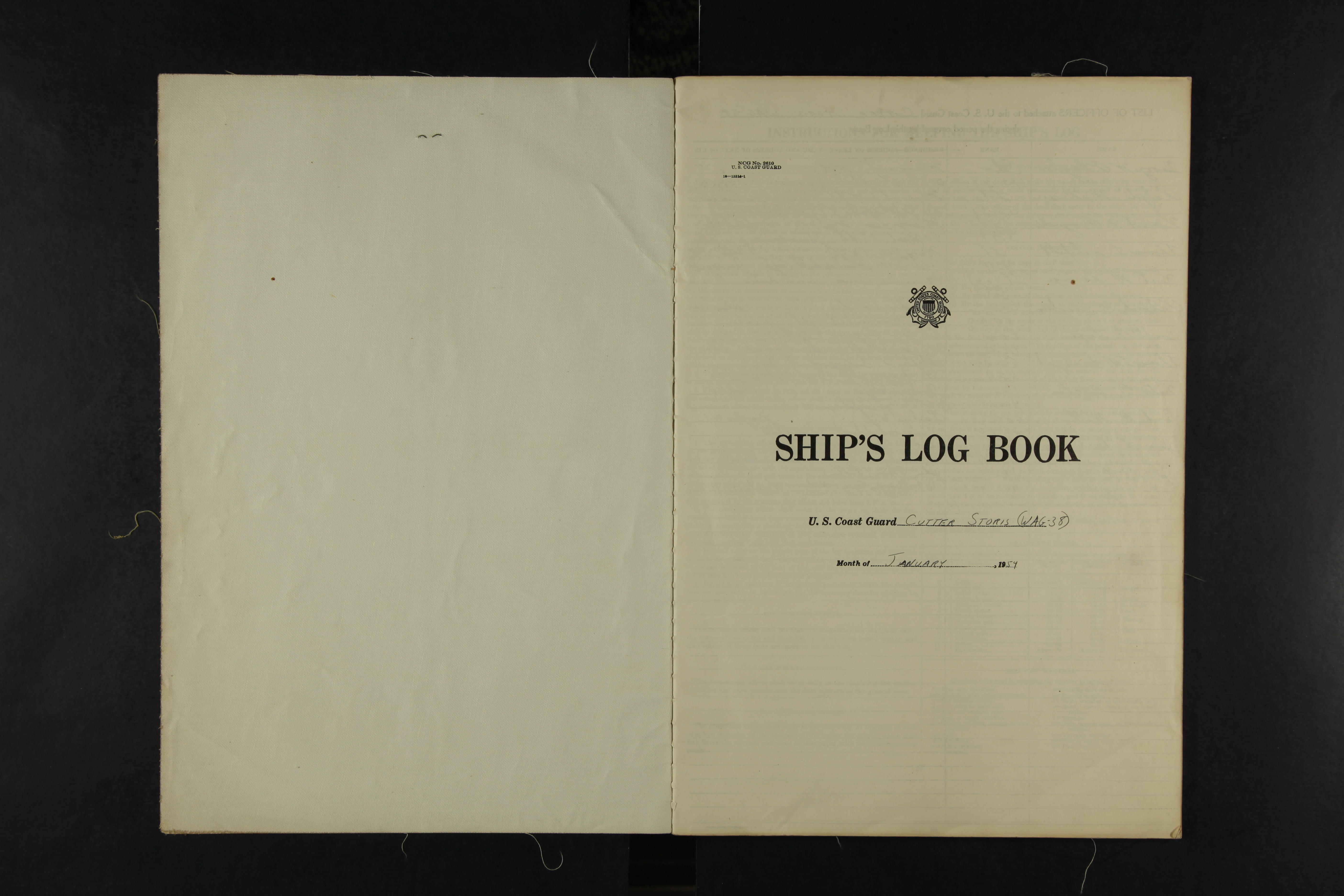
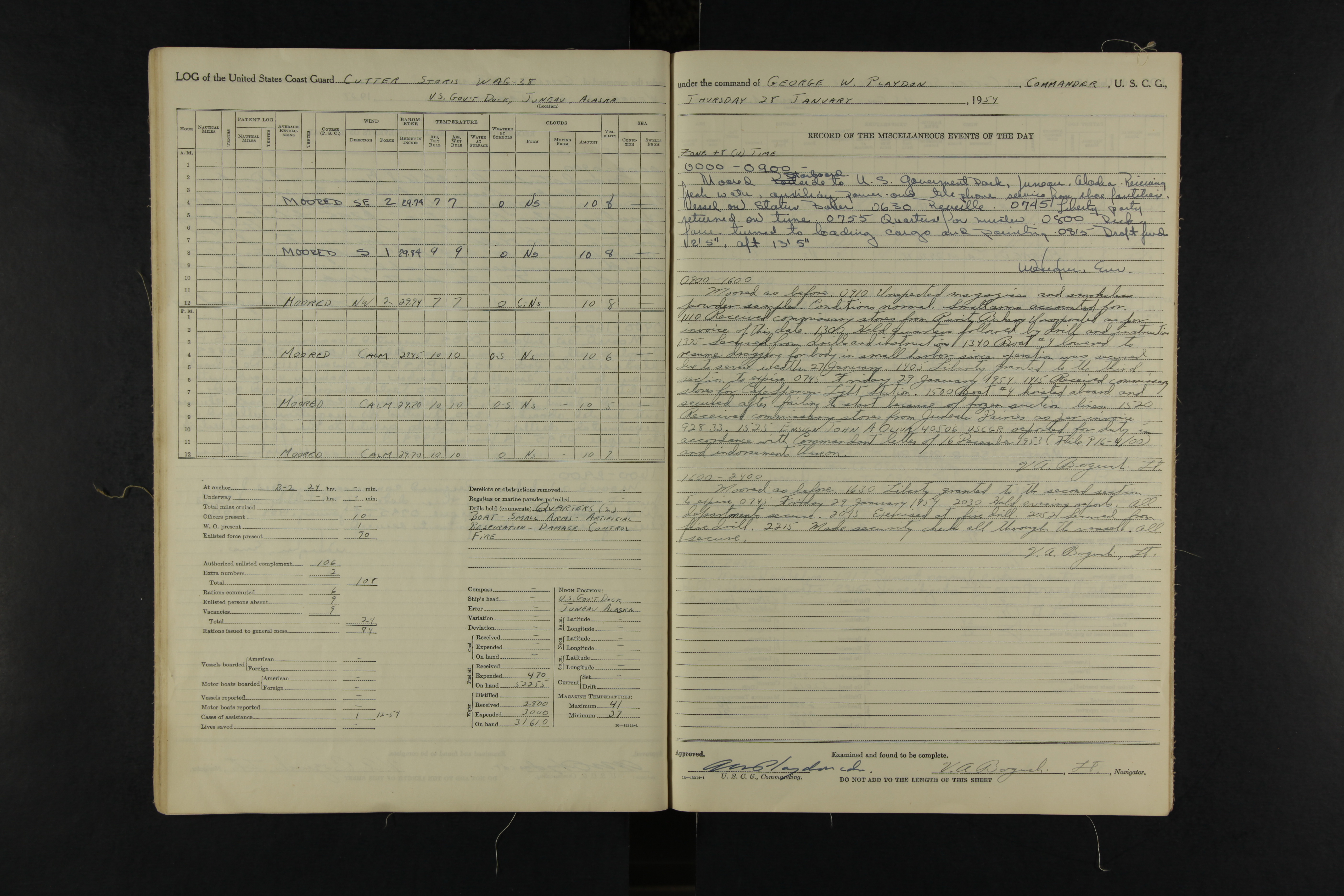
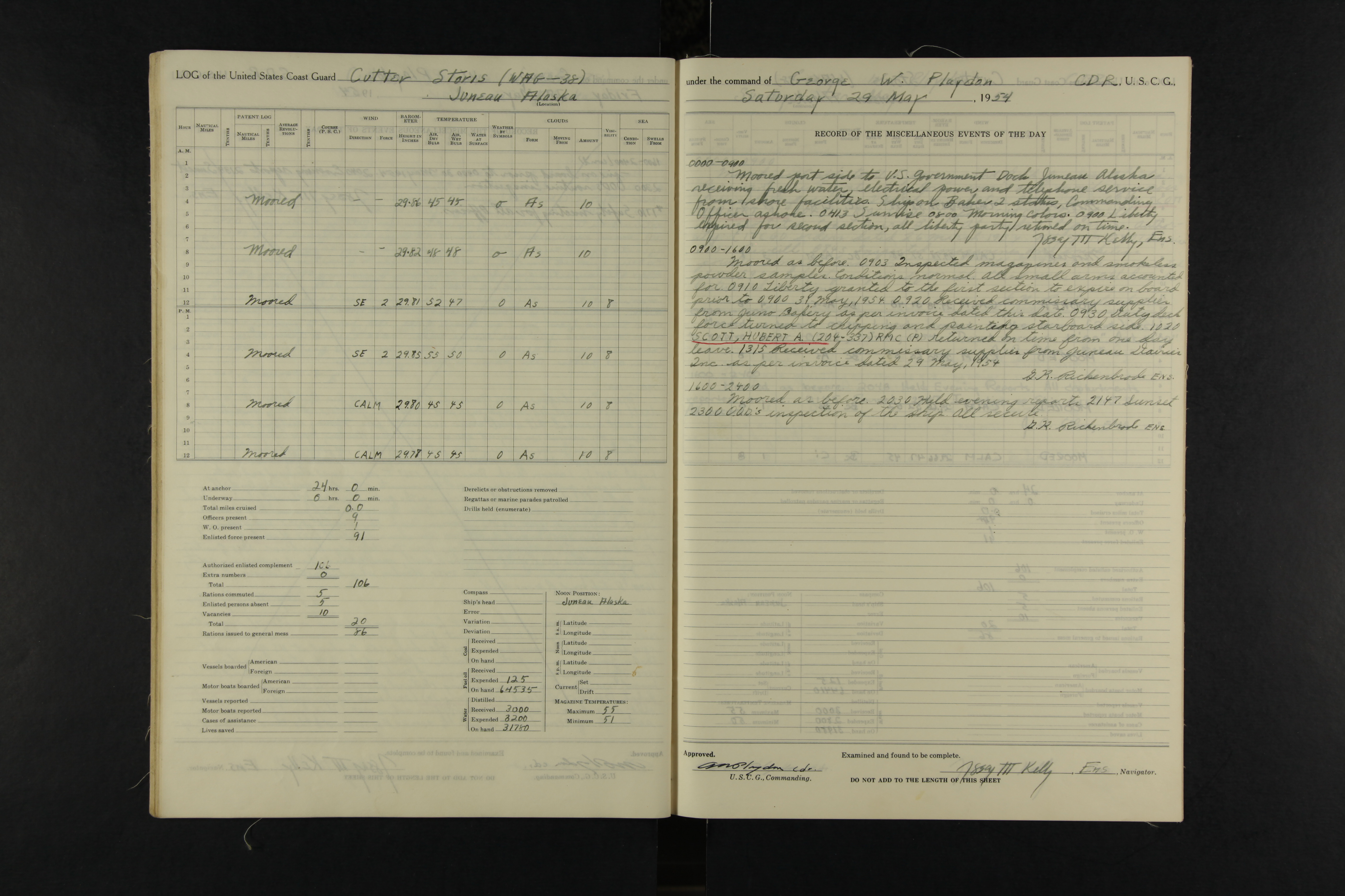
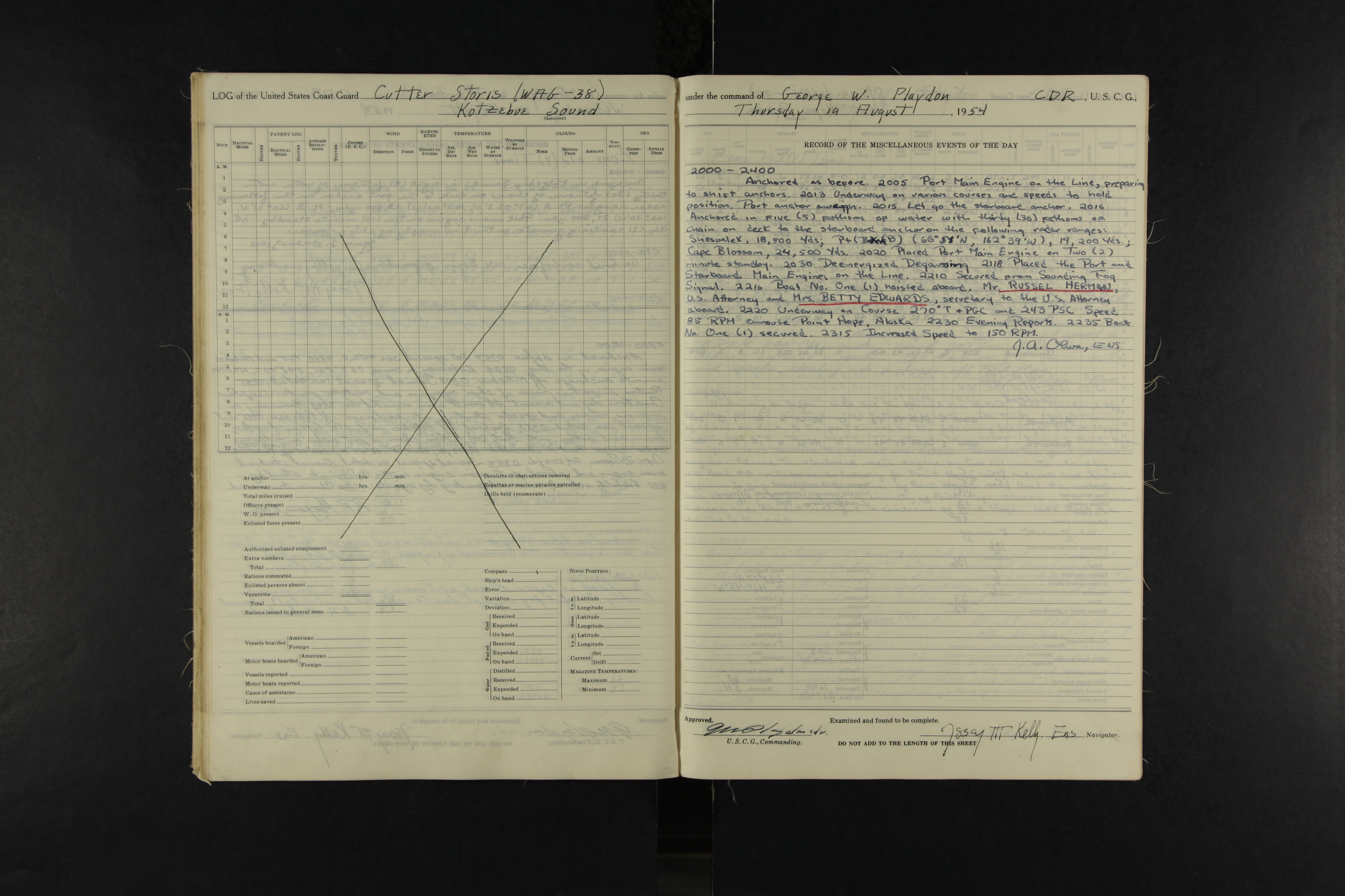
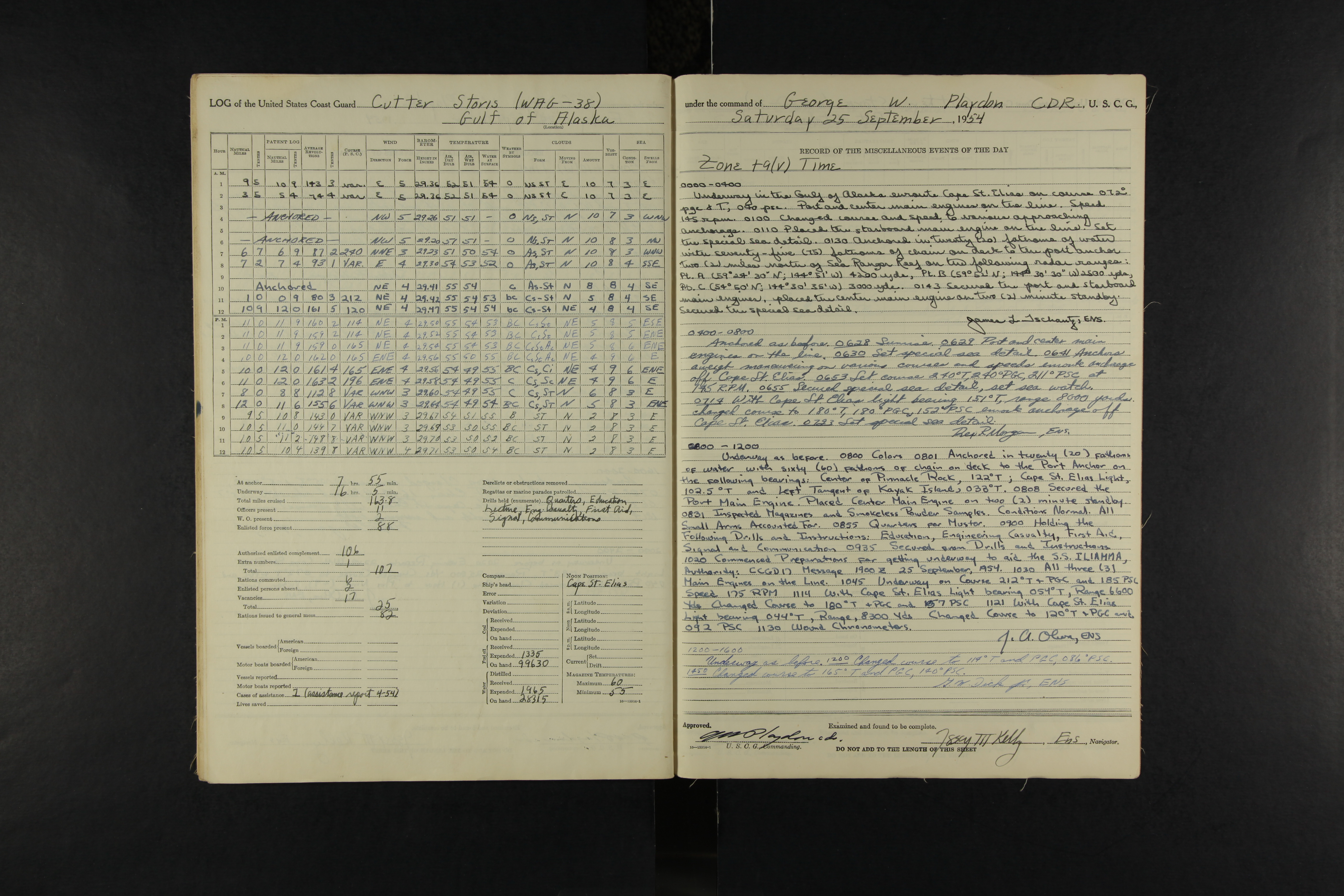
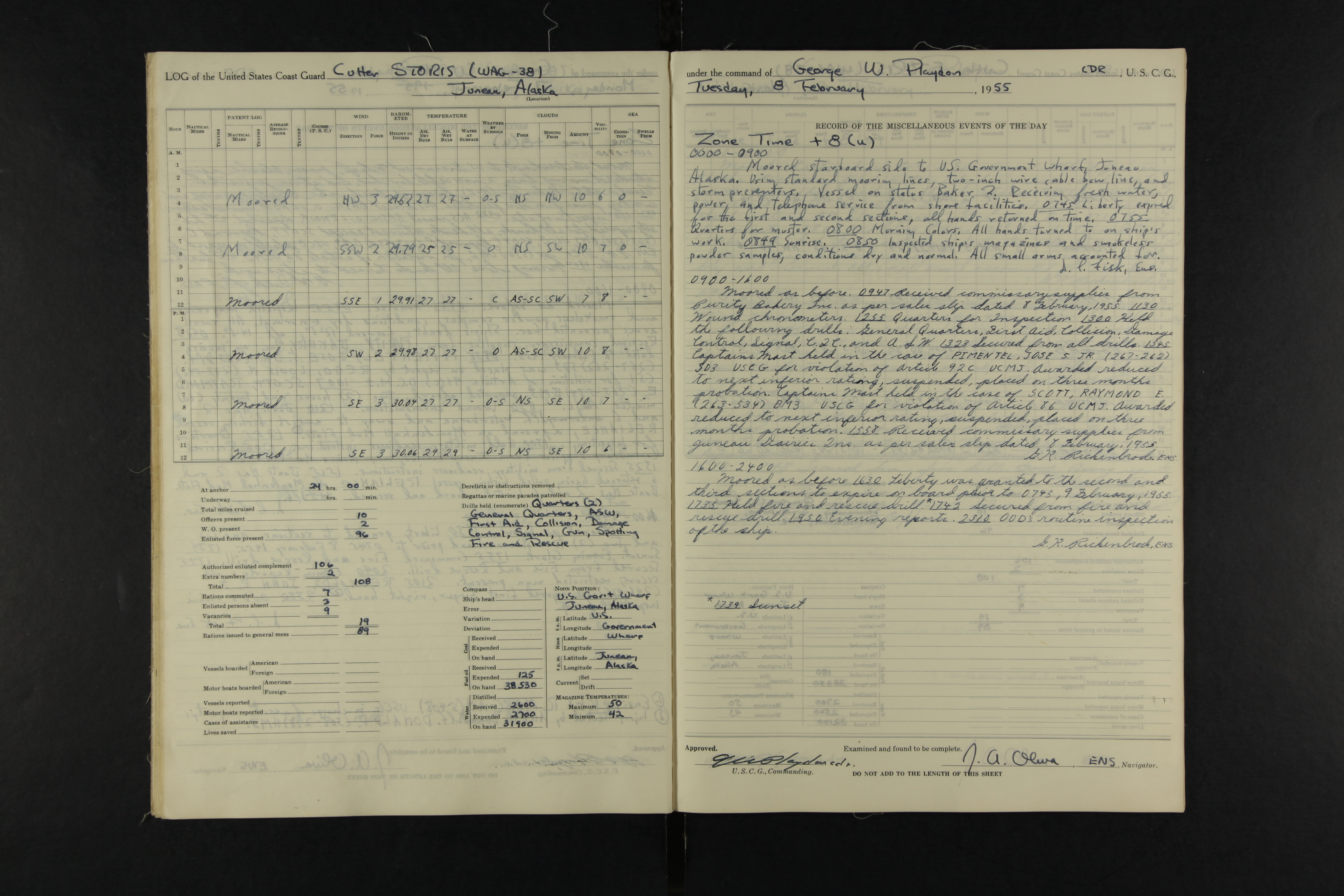
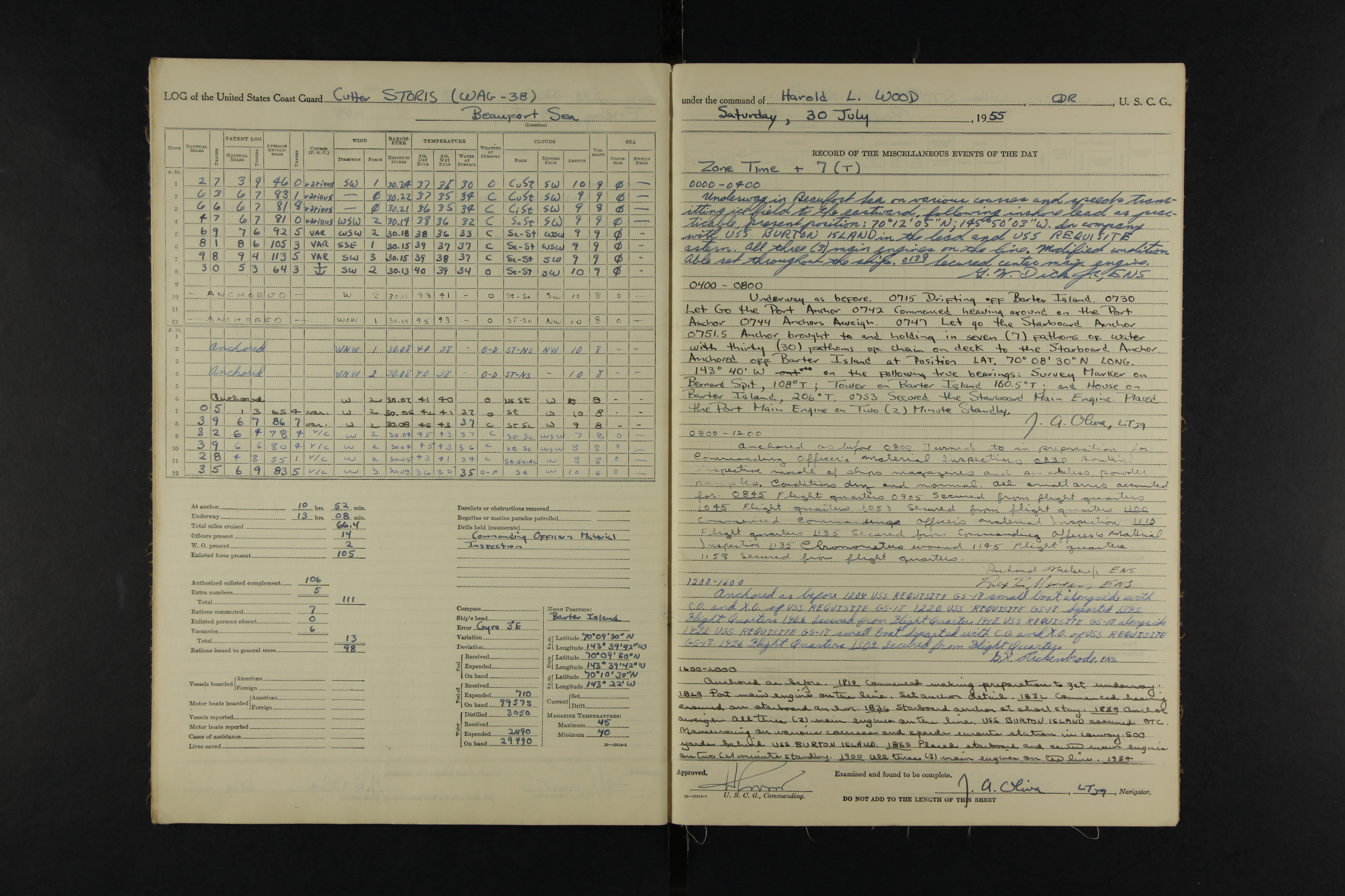
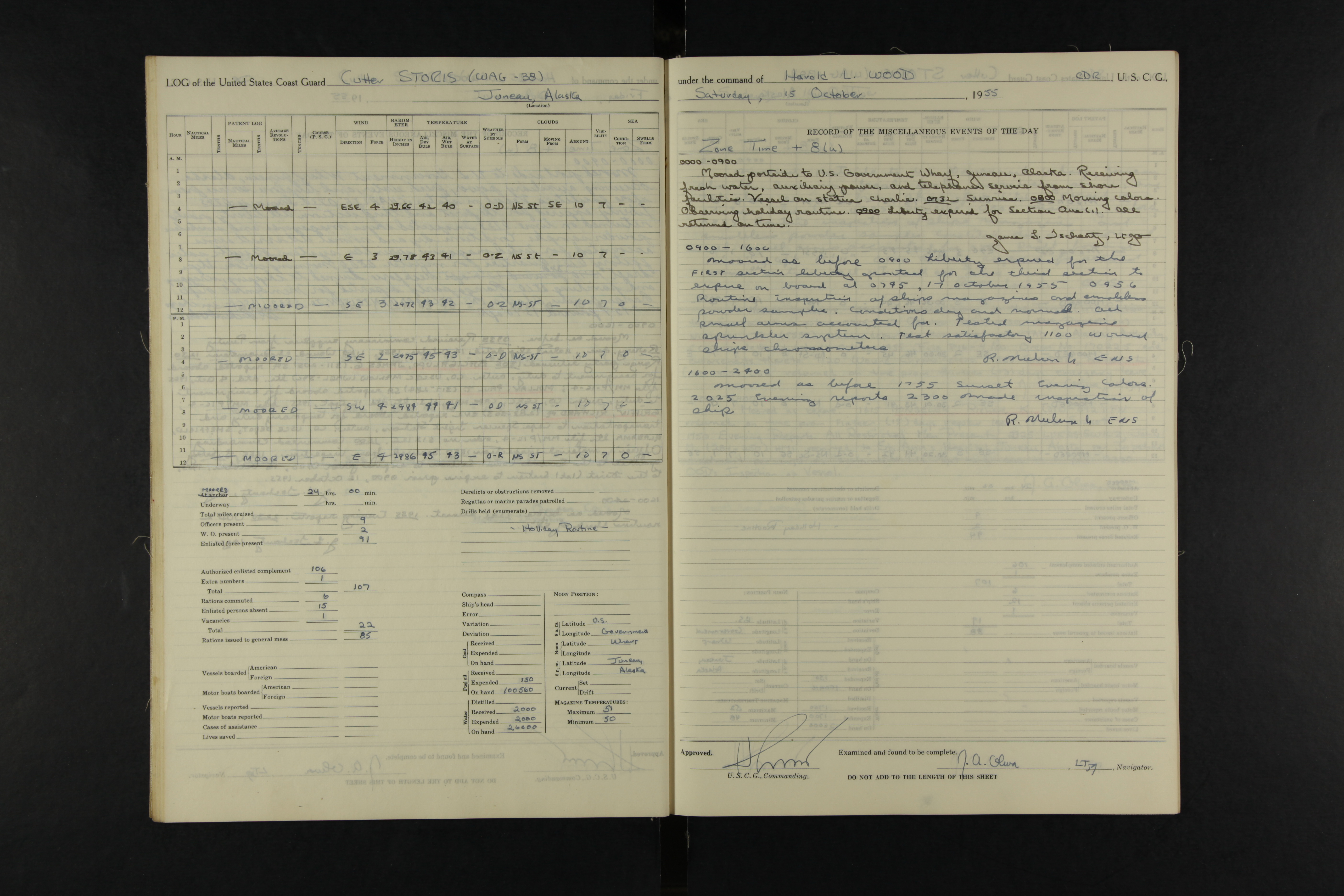